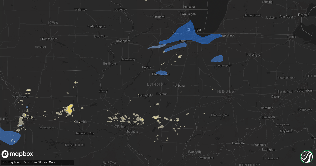
Hail Map in Illinois on July 16, 2025
Get this storm
July 16 map
$229
one time, instant access
Download today. No call, no setup
Keep the $229
Bought the map and want the full workflow? Apply the entire $229 to a subscription within 7 days. None of it is wasted.
Every map, not just this one
This buys you this map. Subscription and you get every map we run, in the markets you choose from a few cities to whole states to nationwide. Plus real-time alerts the moment a storm fires.
Contact data
Name, contact info, occupancy, even credit band for addresses in the footprint. You go from where it hit to who to call.
Become the source they trust
Unlimited branding weather history reports on demand. You already have the documented answer ready for the property owner, and you are the one who showed up with it.
Property data and RoofTrace estimates
Pull up any address you have got, its value and the exact code rules for that jurisdiction, straight from One Click Code. Then RoofTrace estimates the squares, pitch, and roof value, priced the way you price.
Storm reports in Illinois
Illinois
| Date | Description |
|---|---|
| 07/16/20256:30 PM CDT | Tree down in this general location. Time estimated from radar. |
| 07/16/20255:45 PM CDT | Limbs up to 4 inches in diameter snapped in st. Elmo. Time estimated from radar. |
| 07/16/20255:28 PM CDT | Tree down at the ramsey substation. Time estimated from radar. |
| 07/16/20254:43 PM CDT | Several 3 to 6 inch diameter tree limbs down on northwest side of town. Time estimated. |
| 07/16/20254:41 PM CDT | Delayed report: tree down in the godfrey area. Time estimated from radar. |
| 07/16/20254:21 PM CDT | Photo shared of a large... Rotted tree snapped a few feet up from its base... Partially landing on the roof of a house and an adjacent garage building in ashkum. Time e |
| 07/16/20254:08 PM CDT | Corrects previous tstm wnd dmg report from 1 sse jerseyville. Ham radio relayed a report of 60 mph wind gusts and 8 inch tree limbs down near bluebird lane and il route |
| 07/16/20254:06 PM CDT | 6 inch limb snapped one half mile south of us 24 on il 115. |
| 07/16/20254:05 PM CDT | Received picture of a large 8 to 10 inch diameter tree limb down. Time estimated from radar. |
| 07/16/20254:03 PM CDT | Ham radio relayed a report of 60 mph wind gusts and 8 inch tree limbs down near bluebird lane and il route 109. Time estimated by radar. |
| 07/16/20253:58 PM CDT | Photo showing approximately 1 foot diameter tree limb downed onto a mobile home/trailer in blue island... Causing damage to its roof. Time estimated from radar. |
| 07/16/20253:58 PM CDT | A local report indicates 70 MPH wind near 2 SW Orland Park |
| 07/16/20253:52 PM CDT | A piece of a roof blew into the gangway between two buildings. |
| 07/16/20253:51 PM CDT | Numerous reports of downed trees and tree limbs across the marionette manor neighborhood of chicago. Data collected from 311 requests. Time estimated by radar. |
| 07/16/20253:48 PM CDT | Multiple reports of downed trees and tree limbs across the bricktown and buena park neighborhoods of chicago. Data collected from 311 requests. Time estimated by radar. |
| 07/16/20253:46 PM CDT | Tree and powerlines down. |
| 07/16/20253:43 PM CDT | Multiple reports of downed trees and tree limbs across the jefferson park neighborhood of chicago. Data collected from 311 requests. Time estimated by radar. |
| 07/16/20253:43 PM CDT | Report of a 6 inch diameter tree branch down on a street sign. Time estimated from radar. |
| 07/16/20253:43 PM CDT | Received picture of a large tree limb approximately 10 to 12 inches in diameter downed onto a bus bench awning. Time estimated from radar. |
| 07/16/20253:41 PM CDT | Photo relayed via social media of a 4 to 6 inch diameter tree branch downed. Time estimated by radar. |
| 07/16/20253:40 PM CDT | Multiple reports of downed trees and tree limbs across the brighton park... Gage park... Mckinley park... And bridgeport neighborhoods of chicago. Data collected from 3 |
| 07/16/20253:38 PM CDT | Photo relayed on social media of a 1 foot in diameter tree uprooted near linden and prospect in des plaines. A portion of sidewalk was damaged by the uprooted tree... A |
| 07/16/20253:36 PM CDT | Photo shared on social media showing a roughly 8 inch in diameter tree branch snapped in proska park. Time estimated by radar. |
| 07/16/20253:33 PM CDT | Photo shared on social media depicting several 6 inch diameter tree limbs downed in garfield ridge. Time estimated by radar. |
| 07/16/20253:28 PM CDT | Multiple downed tree branches up to 6 inch in diameter. Relayed through social media and the time estimated through radar. |
| 07/16/20253:27 PM CDT | Estimated 60 mph winds. |
| 07/16/20253:25 PM CDT | Multiple public reports of downed trees and large tree limbs from a downburst on the west side of addison. Time estimated from radar. |
| 07/16/20253:24 PM CDT | Corrects previous tstm wnd gst report from 2 sw orland park. |
| 07/16/20253:24 PM CDT | Two areas of concentrated tree damage occurred surrounding north avenue in glendale heights and glen ellyn. Photos depicted numerous hardwood and softwood trees snapped |
| 07/16/20253:22 PM CDT | Picture shows a large tree limb snapped from trunk. Limb appears to be about 7 to 8 inches in diameter. Time estimated from radar. |
| 07/16/20253:21 PM CDT | Received pictures of a roughly 4 to 5 inch diameter tree limb down. Time estimated from radar. |
| 07/16/20253:19 PM CDT | Tree branches down with the largest at 6 inches in diameter. |
| 07/16/20253:18 PM CDT | A local report indicates 60 MPH wind near Bloomington |
| 07/16/20253:15 PM CDT | *** 1 inj *** based on local media reports... A tree branch fell on a vehicle while in motion... Leading to an injury. Time estimated by radar. |
| 07/16/20253:13 PM CDT | A tree fell across a road on the north side of wheaton and one of its limbs went through the windshield of a car driving by. The occupant was transported to the hospita |
| 07/16/20253:12 PM CDT | Powerlines down. |
| 07/16/20253:12 PM CDT | Trees and powerlines down. |
| 07/16/20253:09 PM CDT | 6 inch tree limb down. |
| 07/16/20253:08 PM CDT | Powerlines down. |
| 07/16/20253:07 PM CDT | A local report indicates 62 MPH wind near 2 SSE Naperville |
| 07/16/20253:05 PM CDT | Received picture of part of a 6 to 8 inch diameter tree snapped. Time estimated from radar. |
| 07/16/20253:05 PM CDT | Corrects previous tstm wnd dmg report from 1 s naperville. Received picture of a large 8 to 10 inch diameter tree limb down. Time estimated from radar. |
| 07/16/20253:05 PM CDT | Nws employee reports large 6 to 12 inch diameter tree limb down. Time estimated from radar. |
| 07/16/20253:04 PM CDT | Powerlines down. |
| 07/16/20253:04 PM CDT | Personal weather station. |
| 07/16/20253:02 PM CDT | Large tree branch down blocking roadway. |
| 07/16/20253:00 PM CDT | Tree branches blown down on north mason st in bloomington. |
| 07/16/20253:00 PM CDT | Large tree branch blown down on townley drive in stevenson subdivision and blocking road. Photo on facebook. |
| 07/16/20253:00 PM CDT | Some large trees blown down on roadways in towanda. |
| 07/16/20253:00 PM CDT | Some tree branches blown down at il wesleyan university. |
| 07/16/20252:59 PM CDT | Large tree blown over on emerson street in bloomington. Photo on facebook. |
| 07/16/20252:58 PM CDT | Large spruce tree snapped off on center street in normal. |
| 07/16/20252:56 PM CDT | Large branch broken off along fox creek road. Time estimated. |
| 07/16/20252:56 PM CDT | Tree blown down over north western ave near west seminary ave. Blocking cul-de-sac to nicole court. Photo on facebook. |
| 07/16/20252:55 PM CDT | Corrects previous tstm wnd dmg report from bloomington location. Large tree limbs blown down at corner of west mulberry st and north catherine st. Two photos showing tr |
| 07/16/20252:55 PM CDT | Large tree branch broken at the corner of fedor circle and six points road. Time estimated. |
| 07/16/20252:55 PM CDT | Large tree limbs blown down at corner of west mulberry st and north catherine st. Two photos showing tree branches down with one branch blocking a street. |
| 07/16/20252:54 PM CDT | Photos shared of large tree limbs snapped on at least two trees in island lake. Time estimated from radar. |
| 07/16/20252:54 PM CDT | Tree branches down on cars. |
| 07/16/20252:52 PM CDT | Corrects previous tstm wnd dmg report from oswego. Trees down blocking portions of the roadway. |
| 07/16/20252:52 PM CDT | Trees down and blocking long beach drive. |
| 07/16/20252:49 PM CDT | Photo of a large branch... 15 inches in diameter... Snapped. |
| 07/16/20252:47 PM CDT | Photo showed on social media showed a 6 to 8 inch diameter hardwood tree snapped in half. Time estimated by radar. |
| 07/16/20252:43 PM CDT | Trees fell on powerlines along meadowview lane. |
| 07/16/20252:43 PM CDT | Received picture showing portion of a 4 to 5 inch diameter tree snapped along with a large limb down. Time estimated via radar. |
| 07/16/20252:20 PM CDT | Power poles snapped around leland. Relayed via la salle county so. Time estimated based on radar. |
| 07/16/20252:19 PM CDT | Trees and powerlines down. |
| 07/16/20252:15 PM CDT | Pk58 kt wind gust - awos station kpnt pontiac airport. |
| 07/16/20251:54 PM CDT | Estimated 60-70 mph winds. |
| 07/16/20251:52 PM CDT | Trees down blocking portions of the roadway. |
| 07/16/20251:28 PM CDT | Report of a down power line by the road. |
| 07/16/20251:17 PM CDT | 3 foot diameter tree branches broken off. Time estimated by radar. |
| 07/16/20251:07 PM CDT | Corrects time of previous tstm wnd dmg report from tiskilwa. 3 foot diameter tree branches broken off. Time estimated by radar. |
| 07/16/20253:00 AM CDT | Delayed report: tree down along rt 66. Time estimated from radar. |
| 07/16/20252:26 AM CDT | Delayed report: tree down off of valley rd. Time estimated from radar. |
All States Impacted by Hail Map on July 16, 2025
Cities Impacted by Hail Map on July 16, 2025
- Valentine, NE
- Thedford, NE
- Halsey, NE
- Tryon, NE
- Stapleton, NE
- Purdum, NE
- Dunning, NE
- Arnold, NE
- Dodgeville, WI
- Spring Green, WI
- Ridgeway, WI
- Arena, WI
- Barneveld, WI
- Mazomanie, WI
- Sauk City, WI
- Belleville, WI
- Tiskilwa, IL
- Princeton, IL
- Hennepin, IL
- Granville, IL
- Peru, IL
- Depue, IL
- Spring Valley, IL
- La Salle, IL
- Utica, IL
- Oglesby, IL
- Ottawa, IL
- Dalzell, IL
- Mendota, IL
- Earlville, IL
- Leland, IL
- Serena, IL
- Sheridan, IL
- Wedron, IL
- Marseilles, IL
- Seneca, IL
- Newark, IL
- Millington, IL
- Yorkville, IL
- Sandwich, IL
- Streator, IL
- Grand Ridge, IL
- Ransom, IL
- Verona, IL
- Morris, IL
- Minooka, IL
- Lost City, WV
- Wardensville, WV
- Jacksonville, IL
- Blue Mounds, WI
- Pleasant Plains, IL
- Joliet, IL
- Shorewood, IL
- Plainfield, IL
- Lockport, IL
- Oswego, IL
- Crest Hill, IL
- Mazon, IL
- Coal City, IL
- El Paso, IL
- Success, AR
- Annada, MO
- Elsberry, MO
- Doniphan, MO
- Oxly, MO
- Maynard, AR
- Greenville, MO
- Naylor, MO
- Manitou Springs, CO
- Colorado Springs, CO
- Montgomery, IL
- Naperville, IL
- Aurora, IL
- Homer Glen, IL
- Romeoville, IL
- Bolingbrook, IL
- Palos Heights, IL
- Darien, IL
- Palos Park, IL
- Lemont, IL
- Downers Grove, IL
- Woodridge, IL
- Lisle, IL
- Orland Park, IL
- Westmont, IL
- Warrenville, IL
- Lombard, IL
- Willow Springs, IL
- Wheaton, IL
- Glen Ellyn, IL
- Willowbrook, IL
- Palos Hills, IL
- Oak Brook, IL
- Hickory Hills, IL
- Worth, IL
- Clarendon Hills, IL
- La Grange, IL
- Villa Park, IL
- Bridgeview, IL
- Western Springs, IL
- Summit Argo, IL
- Hinsdale, IL
- Justice, IL
- La Grange Park, IL
- Brookfield, IL
- Channahon, IL
- Wilmington, IL
- Elwood, IL
- New Lenox, IL
- Manhattan, IL
- Gridley, IL
- Flanagan, IL
- Yellow Spring, WV
- Midlothian, IL
- Hometown, IL
- Chicago Ridge, IL
- Riverdale, IL
- Crestwood, IL
- Robbins, IL
- Evergreen Park, IL
- Alsip, IL
- Chicago, IL
- Lyons, IL
- Burbank, IL
- Blue Island, IL
- Oak Lawn, IL
- Riverside, IL
- Westchester, IL
- Hillside, IL
- Berwyn, IL
- Broadview, IL
- Addison, IL
- Glendale Heights, IL
- Elmhurst, IL
- Berkeley, IL
- Cicero, IL
- River Grove, IL
- Oak Park, IL
- Bellwood, IL
- Wood Dale, IL
- Stone Park, IL
- Bensenville, IL
- Franklin Park, IL
- Maywood, IL
- Schiller Park, IL
- Hines, IL
- River Forest, IL
- Forest Park, IL
- Melrose Park, IL
- Plano, IL
- Millbrook, IL
- Sugar Grove, IL
- Bristol, IL
- Geneva, IL
- Mooseheart, IL
- Batavia, IL
- North Aurora, IL
- Wayne, IL
- Bartlett, IL
- West Chicago, IL
- Saint Charles, IL
- Elk Grove Village, IL
- Schaumburg, IL
- Itasca, IL
- Hoffman Estates, IL
- Arlington Heights, IL
- Medinah, IL
- Streamwood, IL
- Winfield, IL
- Hanover Park, IL
- Roselle, IL
- Rolling Meadows, IL
- Bloomingdale, IL
- Mount Prospect, IL
- Carol Stream, IL
- Des Plaines, IL
- Palatine, IL
- Elmwood Park, IL
- Niles, IL
- Harwood Heights, IL
- Park Ridge, IL
- Glenview, IL
- Wheeling, IL
- Northbrook, IL
- Prospect Heights, IL
- Fox Lake, WI
- Raton, NM
- Rollinsville, CO
- Black Hawk, CO
- Brooklyn, WI
- Silex, MO
- Livermore, CO
- Pontiac, IL
- Hustisford, WI
- Morton Grove, IL
- Lincolnwood, IL
- Skokie, IL
- Golf, IL
- Evanston, IL
- Wilmette, IL
- Winnetka, IL
- Glencoe, IL
- Highland Park, IL
- Kenilworth, IL
- Bloomington, IL
- Carlock, IL
- Normal, IL
- Hudson, IL
- Towanda, IL
- Danvers, IL
- Downs, IL
- Ellsworth, IL
- Cooksville, IL
- Fairbury, IL
- Saunemin, IL
- Forrest, IL
- Golden, CO
- Cross Junction, VA
- Sedalia, CO
- Fieldon, IL
- Emington, IL
- Eolia, MO
- Troy, MO
- Cameron, NC
- Buckingham, IL
- Cabery, IL
- Castle Rock, CO
- Jerseyville, IL
- Medora, IL
- Reddick, IL
- Dwight, IL
- Yellville, AR
- Foley, MO
- Hardin, IL
- Brussels, IL
- Batchtown, IL
- Sanford, NC
- Campbell, MO
- Chesterfield, IL
- Morrisonville, IL
- Kaibeto, AZ
- Grafton, IL
- Berkeley Springs, WV
- Winchester, VA
- Herron, MI
- Lachine, MI
- Carpenter, WY
- Taylorville, IL
- Assumption, IL
- Wellington, CO
- Fort Collins, CO
- Grover, CO
- Palmer, IL
- Hardin, MO
- Clay City, IL
- Louisville, IL
- Big Pool, MD
- Clear Spring, MD
- Owaneco, IL
- Nunn, CO
- Flora, IL
- Franktown, CO
- Dow, IL
- Elsah, IL
- Elbert, CO
- Larkspur, CO
- Hedgesville, WV
- Pierce, CO
- Mokena, IL
- Oak Forest, IL
- Flossmoor, IL
- South Holland, IL
- Posen, IL
- Harvey, IL
- Hazel Crest, IL
- Calumet City, IL
- Tinley Park, IL
- Lansing, IL
- Dolton, IL
- Homewood, IL
- Chicago Heights, IL
- Country Club Hills, IL
- Glenwood, IL
- Thornton, IL
- Markham, IL
- East Chicago, IN
- Hammond, IN
- Whiting, IN
- Munster, IN
- Gary, IN
- Highland, IN
- Dyer, IN
- Merrillville, IN
- Schererville, IN
- Griffith, IN
- Crown Point, IN
- Wanatah, IN
- Hobart, IN
- Lake Station, IN
- Hebron, IN
- Chesterton, IN
- Valparaiso, IN
- Portage, IN
- Westville, IN
- Ingraham, IL
- Noble, IL
- Nekoma, KS
- Rush Center, KS
- Staunton, IL
- Warrenton, MO
- Truxton, MO
- Hawk Point, MO
- Philo, IL
- Villa Grove, IL
- Westcliffe, CO
- Olney, IL
- Fountain, CO
- La Porte, IN
- Michigan City, IN
- Union Mills, IN
- Beverly Shores, IN
- Dundas, IL
- Fillmore, IL
- Glasgow, MO
- Orrick, MO
- Briggsdale, CO
- Coffeen, IL
- Bingham, IL
- Mars, PA
- Warrendale, PA
- Wexford, PA
- Baden, PA
- Bradfordwoods, PA
- Cranberry Township, PA
- Des Moines, NM
- Capulin, NM
- Springer, NM
- Rozel, KS
- Ramsey, IL
- Wetmore, CO
- Upper Tract, WV
- Buford, WY
- Monticello, WI
- New Glarus, WI
- Allison Park, PA
- Gibsonia, PA
- Ranson, WV
- Kearneysville, WV
- Charles Town, WV
- Summit Point, WV
- Pittsburgh, PA
- Glenshaw, PA
- New Carlisle, IN
- Mill Creek, IN
- Rolling Prairie, IN
- Monon, IN
- Winamac, IN
- Francesville, IN
- Monticello, IN
- Star City, IN
- Beulah, CO
- Pueblo, CO
- Buffalo, IN
- Royal Center, IN
- Burnettsville, IN
- Kewanna, IN
- Burdett, KS
- Bentonville, VA
- Armstrong, MO
- Salisbury, MO
- Mulberry Grove, IL
- Vandalia, IL
- Harpers Ferry, WV
- Cheswick, PA
- Bairdford, PA
- Purgitsville, WV
- Romney, WV
- Russellton, PA
- Tarentum, PA
- Bakerstown, PA
- Cheyenne, WY
- Stoneham, CO
- Shobonier, IL
- Brownstown, IL
- Huntly, VA
- Berryville, VA
- Saint Elmo, IL
- Purcellville, VA
- Sewickley, PA
- Zelienople, PA
- Evans City, PA
- Hanston, KS
- Watson, IL
- Effingham, IL
- Snyder, CO
- Chester Gap, VA
- Flint Hill, VA
- Franklin, WV
- Altamont, IL
- Beecher City, IL
- Mason, IL
- Vernon, IL
- Alma, IL
- Alexander, KS
- High View, WV
- Patoka, IL
- New Raymer, CO
- Waterford, VA
- Lovettsville, VA
- Rye, CO
- Delray, WV
- Augusta, WV
- Larned, KS
- Kinsley, KS
- Millville, WV
- Merino, CO
- Bluemont, VA
- Martinsville, IL
- Higbee, MO
- Gardner, CO
- Annapolis, IL
- Casey, IL
- Wheeler, IL
- New Ross, IN
- Crawfordsville, IN
- Kinmundy, IL
- Moberly, MO
- Madison, MO
- Colorado City, CO
- Keytesville, MO
- Leesburg, VA
- Paeonian Springs, VA
- Hamilton, VA
- Akron, CO
- Hillrose, CO
- Clifton Hill, MO
- Marshall, VA
- Dieterich, IL
- Newton, IL
- Addison, NY
- Folsom, NM
- Huntsville, MO
- Millstone Township, NJ
- Walsenburg, CO
- Spearville, KS
- Jetmore, KS
- The Plains, VA
- Warrenton, VA
- Bluford, IL
- Valencia, PA
- Timberville, VA
- New Market, VA
- Broadway, VA
- Wright, KS
- Grenville, NM
- Ashley, IL
- Du Bois, IL
- Richview, IL
- Woodlawn, IL
- Keenes, IL
- Centralia, IL
- Broad Run, VA
- Lucerne, IN
- Dodge City, KS
- Brunswick, MO
- Avondale, CO
- Jasonville, IN
- Fulks Run, VA
- Riverside, MO
- Kansas City, MO
- Kansas City, KS
- Luray, VA
- Stanley, VA
- Cisne, IL
- Milliken, CO
- Fowler, CO
- Model, CO
- Slater, MO
- Dalton, MO
- Minneola, KS
- Johnstown, CO
- Bowling Green, MO
- Middletown, MO
- Ensign, KS
- Fowler, KS
- Montezuma, KS
- Meade, KS
- Plains, KS
- Philippi, WV
- Moatsville, WV
- Flemington, WV
- Parsons, WV
- Rowlesburg, WV
- Tunnelton, WV
- Terra Alta, WV
- Aurora, WV
- Thornton, WV
- Oakland, MD
- Nanty Glo, PA
- Ebensburg, PA
- Loretto, PA
- Gallitzin, PA
- Ashville, PA
- Dysart, PA
- Chest Springs, PA
- Fallentimber, PA
- Patton, PA
- Fe Warren Afb, WY
- Olathe, KS
- Gardner, KS
- New Century, KS
- Smithville, MO
- Johnson, KS
- Ulysses, KS
- Harveyville, KS
- Auburn, KS
- Paxico, KS
- Maple Hill, KS
- Eskridge, KS
- Topeka, KS
- Alma, KS
- Allen, KS
- Reading, KS
- Admire, KS
- Burlingame, KS
- Wakarusa, KS
- Carbondale, KS
- Osage City, KS
- Scranton, KS
- Silver Lake, KS
- Emmett, KS
- Belvue, KS
- Onaga, KS
- Delia, KS
- Saint Marys, KS
- McFarland, KS
- Wamego, KS
- Rossville, KS
- Saint George, KS
- Westmoreland, KS
- Lebo, KS
- Lyndon, KS
- Melvern, KS
- Waverly, KS
- Wellsville, KS
- Rantoul, KS
- Ottawa, KS
- Princeton, KS
- Williamsburg, KS
- Vassar, KS
- Pomona, KS
- Quenemo, KS
- Overbrook, KS
- Garnett, KS
- Westphalia, KS
- Richmond, KS
- Welda, KS
- Paola, KS
- Greeley, KS
- Osawatomie, KS
- Lane, KS
- Parker, KS
- Centerville, KS
- Fontana, KS
- Amity, MO
- Sweet Springs, MO
- Faucett, MO
- Agency, MO
- Hebron, NE
- Gilead, NE
- Independence, MO
- Fayette, MO
- Malta Bend, MO
- Blackburn, MO
- Selden, KS
- Nelson, MO
- Marshall, MO
- King City, MO
- Union Star, MO
- Fairbury, NE
- Alexandria, NE
- Nettie, WV
- Rocky Ford, CO
- Dearborn, MO
- Hoxie, KS
- Clarksdale, MO
- Cosby, MO
- Helena, MO
- Maysville, MO
- Gilliam, MO
- Cameron, MO
- Miami, MO
- Tecumseh, NE
- Brock, NE
- Johnson, NE
- Cook, NE
- Columbia, MO
- Lebanon, KS
- Holly, CO
- Boonville, MO
- Hunter, KS
- Shipman, IL
- Bonner Springs, KS
- Shawnee, KS
- Lenexa, KS
- Syracuse, KS
- Wakeeney, KS
- Gillespie, IL
- Bucklin, MO
- Beloit, KS
- Agra, KS
- Phillipsburg, KS
- Lakin, KS
- Kensington, KS
- De Kalb, MO
- Saint Joseph, MO
- Winfield, MO
- Brashear, MO
- Kirksville, MO
- Hugoton, KS
- Goodwell, OK
- Golden Eagle, IL
- Piasa, IL
- Stewartsville, MO
- Talmage, NE
- La Plata, MO
- Godfrey, IL
- Mosquero, NM
- Bunker Hill, IL
- Auburn, NE
- Mount Olive, IL
- Brighton, IL
- O'Fallon, MO
- Dorsey, IL
- Wood River, IL
- Bethalto, IL
- Moro, IL
- Alton, IL
- East Alton, IL
- Cottage Hills, IL
- Benld, IL
- New Douglas, IL
- Carlinville, IL
- Livingston, IL
- Edwardsville, IL
- Wilsonville, IL
- Alhambra, IL
- Sawyerville, IL
- Worden, IL
- West Alton, MO
- Portage Des Sioux, MO
- Mayview, MO
- Lexington, MO
- Bucyrus, KS
- Spring Hill, KS
- Louisburg, KS
- Saint Charles, MO
- Edgerton, KS
- Walnut Hill, IL
- Henrietta, MO
- Higginsville, MO
- Moscow Mills, MO
- Jonesburg, MO
- Overland Park, KS
- Sandoval, IL
- Hoyleton, IL
- Hamburg, IL


