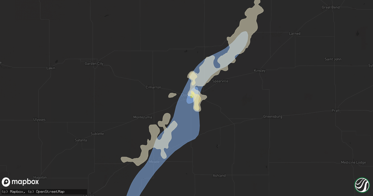
Hail Map in Dodge City, KS on July 16, 2025
Get this storm
July 16 map
$229
one time, instant access
Download today. No call, no setup
Keep the $229
Bought the map and want the full workflow? Apply the entire $229 to a subscription within 7 days. None of it is wasted.
Every map, not just this one
This buys you this map. Subscription and you get every map we run, in the markets you choose from a few cities to whole states to nationwide. Plus real-time alerts the moment a storm fires.
Contact data
Name, contact info, occupancy, even credit band for addresses in the footprint. You go from where it hit to who to call.
Become the source they trust
Unlimited branding weather history reports on demand. You already have the documented answer ready for the property owner, and you are the one who showed up with it.
Property data and RoofTrace estimates
Pull up any address you have got, its value and the exact code rules for that jurisdiction, straight from One Click Code. Then RoofTrace estimates the squares, pitch, and roof value, priced the way you price.
Storm reports in Dodge City, KS
Dodge City, KS
| Date | Description |
|---|---|
| 07/15/20258:30 PM CDT | Several 14-to-16-inch tree limbs blown down. |
| 07/15/20258:25 PM CDT | Two telephone poles blown down on highway 283 near the expo center south of dodge city. |
| 07/15/20258:15 PM CDT | Roof blown off a trailer house located on the 2700 block of east trail street. |
| 07/15/20258:10 PM CDT | A local report indicates 1.00 inch wind near 1 ENE Dodge City |
| 07/15/20258:10 PM CDT | Tree blown down across the road. |
| 07/15/20258:04 PM CDT | Report received from the asos station kddc dodge city regional airport. |
| 07/15/20258:02 PM CDT | Report received from the dodge city american implement awn weather station. |
| 07/15/20257:56 PM CDT | 3 inch diameter tree was blown down in chilton park. |
| 07/15/20257:55 PM CDT | Dodge city asos reported 77 mph winds. |
| 07/15/20257:51 PM CDT | Mesonet site on north side of dodge city. |
| 07/15/20257:21 PM CDT | Report received from wxrfs weather station. |
All States Impacted by Hail Map on July 16, 2025
All Cities Impacted by Hail Map on July 16, 2025
- Valentine, NE
- Thedford, NE
- Halsey, NE
- Tryon, NE
- Stapleton, NE
- Purdum, NE
- Dunning, NE
- Arnold, NE
- Dodgeville, WI
- Spring Green, WI
- Ridgeway, WI
- Arena, WI
- Barneveld, WI
- Mazomanie, WI
- Sauk City, WI
- Belleville, WI
- Tiskilwa, IL
- Princeton, IL
- Hennepin, IL
- Granville, IL
- Peru, IL
- Depue, IL
- Spring Valley, IL
- La Salle, IL
- Utica, IL
- Oglesby, IL
- Ottawa, IL
- Dalzell, IL
- Mendota, IL
- Earlville, IL
- Leland, IL
- Serena, IL
- Sheridan, IL
- Wedron, IL
- Marseilles, IL
- Seneca, IL
- Newark, IL
- Millington, IL
- Yorkville, IL
- Sandwich, IL
- Streator, IL
- Grand Ridge, IL
- Ransom, IL
- Verona, IL
- Morris, IL
- Minooka, IL
- Lost City, WV
- Wardensville, WV
- Jacksonville, IL
- Blue Mounds, WI
- Pleasant Plains, IL
- Joliet, IL
- Shorewood, IL
- Plainfield, IL
- Lockport, IL
- Oswego, IL
- Crest Hill, IL
- Mazon, IL
- Coal City, IL
- El Paso, IL
- Success, AR
- Annada, MO
- Elsberry, MO
- Doniphan, MO
- Oxly, MO
- Maynard, AR
- Greenville, MO
- Naylor, MO
- Manitou Springs, CO
- Colorado Springs, CO
- Montgomery, IL
- Naperville, IL
- Aurora, IL
- Homer Glen, IL
- Romeoville, IL
- Bolingbrook, IL
- Palos Heights, IL
- Darien, IL
- Palos Park, IL
- Lemont, IL
- Downers Grove, IL
- Woodridge, IL
- Lisle, IL
- Orland Park, IL
- Westmont, IL
- Warrenville, IL
- Lombard, IL
- Willow Springs, IL
- Wheaton, IL
- Glen Ellyn, IL
- Willowbrook, IL
- Palos Hills, IL
- Oak Brook, IL
- Hickory Hills, IL
- Worth, IL
- Clarendon Hills, IL
- La Grange, IL
- Villa Park, IL
- Bridgeview, IL
- Western Springs, IL
- Summit Argo, IL
- Hinsdale, IL
- Justice, IL
- La Grange Park, IL
- Brookfield, IL
- Channahon, IL
- Wilmington, IL
- Elwood, IL
- New Lenox, IL
- Manhattan, IL
- Gridley, IL
- Flanagan, IL
- Yellow Spring, WV
- Midlothian, IL
- Hometown, IL
- Chicago Ridge, IL
- Riverdale, IL
- Crestwood, IL
- Robbins, IL
- Evergreen Park, IL
- Alsip, IL
- Chicago, IL
- Lyons, IL
- Burbank, IL
- Blue Island, IL
- Oak Lawn, IL
- Riverside, IL
- Westchester, IL
- Hillside, IL
- Berwyn, IL
- Broadview, IL
- Addison, IL
- Glendale Heights, IL
- Elmhurst, IL
- Berkeley, IL
- Cicero, IL
- River Grove, IL
- Oak Park, IL
- Bellwood, IL
- Wood Dale, IL
- Stone Park, IL
- Bensenville, IL
- Franklin Park, IL
- Maywood, IL
- Schiller Park, IL
- Hines, IL
- River Forest, IL
- Forest Park, IL
- Melrose Park, IL
- Plano, IL
- Millbrook, IL
- Sugar Grove, IL
- Bristol, IL
- Geneva, IL
- Mooseheart, IL
- Batavia, IL
- North Aurora, IL
- Wayne, IL
- Bartlett, IL
- West Chicago, IL
- Saint Charles, IL
- Elk Grove Village, IL
- Schaumburg, IL
- Itasca, IL
- Hoffman Estates, IL
- Arlington Heights, IL
- Medinah, IL
- Streamwood, IL
- Winfield, IL
- Hanover Park, IL
- Roselle, IL
- Rolling Meadows, IL
- Bloomingdale, IL
- Mount Prospect, IL
- Carol Stream, IL
- Des Plaines, IL
- Palatine, IL
- Elmwood Park, IL
- Niles, IL
- Harwood Heights, IL
- Park Ridge, IL
- Glenview, IL
- Wheeling, IL
- Northbrook, IL
- Prospect Heights, IL
- Fox Lake, WI
- Raton, NM
- Rollinsville, CO
- Black Hawk, CO
- Brooklyn, WI
- Silex, MO
- Livermore, CO
- Pontiac, IL
- Hustisford, WI
- Morton Grove, IL
- Lincolnwood, IL
- Skokie, IL
- Golf, IL
- Evanston, IL
- Wilmette, IL
- Winnetka, IL
- Glencoe, IL
- Highland Park, IL
- Kenilworth, IL
- Bloomington, IL
- Carlock, IL
- Normal, IL
- Hudson, IL
- Towanda, IL
- Danvers, IL
- Downs, IL
- Ellsworth, IL
- Cooksville, IL
- Fairbury, IL
- Saunemin, IL
- Forrest, IL
- Golden, CO
- Cross Junction, VA
- Sedalia, CO
- Fieldon, IL
- Emington, IL
- Eolia, MO
- Troy, MO
- Cameron, NC
- Buckingham, IL
- Cabery, IL
- Castle Rock, CO
- Jerseyville, IL
- Medora, IL
- Reddick, IL
- Dwight, IL
- Yellville, AR
- Foley, MO
- Hardin, IL
- Brussels, IL
- Batchtown, IL
- Sanford, NC
- Campbell, MO
- Chesterfield, IL
- Morrisonville, IL
- Kaibeto, AZ
- Grafton, IL
- Berkeley Springs, WV
- Winchester, VA
- Herron, MI
- Lachine, MI
- Carpenter, WY
- Taylorville, IL
- Assumption, IL
- Wellington, CO
- Fort Collins, CO
- Grover, CO
- Palmer, IL
- Hardin, MO
- Clay City, IL
- Louisville, IL
- Big Pool, MD
- Clear Spring, MD
- Owaneco, IL
- Nunn, CO
- Flora, IL
- Franktown, CO
- Dow, IL
- Elsah, IL
- Elbert, CO
- Larkspur, CO
- Hedgesville, WV
- Pierce, CO
- Mokena, IL
- Oak Forest, IL
- Flossmoor, IL
- South Holland, IL
- Posen, IL
- Harvey, IL
- Hazel Crest, IL
- Calumet City, IL
- Tinley Park, IL
- Lansing, IL
- Dolton, IL
- Homewood, IL
- Chicago Heights, IL
- Country Club Hills, IL
- Glenwood, IL
- Thornton, IL
- Markham, IL
- East Chicago, IN
- Hammond, IN
- Whiting, IN
- Munster, IN
- Gary, IN
- Highland, IN
- Dyer, IN
- Merrillville, IN
- Schererville, IN
- Griffith, IN
- Crown Point, IN
- Wanatah, IN
- Hobart, IN
- Lake Station, IN
- Hebron, IN
- Chesterton, IN
- Valparaiso, IN
- Portage, IN
- Westville, IN
- Ingraham, IL
- Noble, IL
- Nekoma, KS
- Rush Center, KS
- Staunton, IL
- Warrenton, MO
- Truxton, MO
- Hawk Point, MO
- Philo, IL
- Villa Grove, IL
- Westcliffe, CO
- Olney, IL
- Fountain, CO
- La Porte, IN
- Michigan City, IN
- Union Mills, IN
- Beverly Shores, IN
- Dundas, IL
- Fillmore, IL
- Glasgow, MO
- Orrick, MO
- Briggsdale, CO
- Coffeen, IL
- Bingham, IL
- Mars, PA
- Warrendale, PA
- Wexford, PA
- Baden, PA
- Bradfordwoods, PA
- Cranberry Township, PA
- Des Moines, NM
- Capulin, NM
- Springer, NM
- Rozel, KS
- Ramsey, IL
- Wetmore, CO
- Upper Tract, WV
- Buford, WY
- Monticello, WI
- New Glarus, WI
- Allison Park, PA
- Gibsonia, PA
- Ranson, WV
- Kearneysville, WV
- Charles Town, WV
- Summit Point, WV
- Pittsburgh, PA
- Glenshaw, PA
- New Carlisle, IN
- Mill Creek, IN
- Rolling Prairie, IN
- Monon, IN
- Winamac, IN
- Francesville, IN
- Monticello, IN
- Star City, IN
- Beulah, CO
- Pueblo, CO
- Buffalo, IN
- Royal Center, IN
- Burnettsville, IN
- Kewanna, IN
- Burdett, KS
- Bentonville, VA
- Armstrong, MO
- Salisbury, MO
- Mulberry Grove, IL
- Vandalia, IL
- Harpers Ferry, WV
- Cheswick, PA
- Bairdford, PA
- Purgitsville, WV
- Romney, WV
- Russellton, PA
- Tarentum, PA
- Bakerstown, PA
- Cheyenne, WY
- Stoneham, CO
- Shobonier, IL
- Brownstown, IL
- Huntly, VA
- Berryville, VA
- Saint Elmo, IL
- Purcellville, VA
- Sewickley, PA
- Zelienople, PA
- Evans City, PA
- Hanston, KS
- Watson, IL
- Effingham, IL
- Snyder, CO
- Chester Gap, VA
- Flint Hill, VA
- Franklin, WV
- Altamont, IL
- Beecher City, IL
- Mason, IL
- Vernon, IL
- Alma, IL
- Alexander, KS
- High View, WV
- Patoka, IL
- New Raymer, CO
- Waterford, VA
- Lovettsville, VA
- Rye, CO
- Delray, WV
- Augusta, WV
- Larned, KS
- Kinsley, KS
- Millville, WV
- Merino, CO
- Bluemont, VA
- Martinsville, IL
- Higbee, MO
- Gardner, CO
- Annapolis, IL
- Casey, IL
- Wheeler, IL
- New Ross, IN
- Crawfordsville, IN
- Kinmundy, IL
- Moberly, MO
- Madison, MO
- Colorado City, CO
- Keytesville, MO
- Leesburg, VA
- Paeonian Springs, VA
- Hamilton, VA
- Akron, CO
- Hillrose, CO
- Clifton Hill, MO
- Marshall, VA
- Dieterich, IL
- Newton, IL
- Addison, NY
- Folsom, NM
- Huntsville, MO
- Millstone Township, NJ
- Walsenburg, CO
- Spearville, KS
- Jetmore, KS
- The Plains, VA
- Warrenton, VA
- Bluford, IL
- Valencia, PA
- Timberville, VA
- New Market, VA
- Broadway, VA
- Wright, KS
- Grenville, NM
- Ashley, IL
- Du Bois, IL
- Richview, IL
- Woodlawn, IL
- Keenes, IL
- Centralia, IL
- Broad Run, VA
- Lucerne, IN
- Dodge City, KS
- Brunswick, MO
- Avondale, CO
- Jasonville, IN
- Fulks Run, VA
- Riverside, MO
- Kansas City, MO
- Kansas City, KS
- Luray, VA
- Stanley, VA
- Cisne, IL
- Milliken, CO
- Fowler, CO
- Model, CO
- Slater, MO
- Dalton, MO
- Minneola, KS
- Johnstown, CO
- Bowling Green, MO
- Middletown, MO
- Ensign, KS
- Fowler, KS
- Montezuma, KS
- Meade, KS
- Plains, KS
- Philippi, WV
- Moatsville, WV
- Flemington, WV
- Parsons, WV
- Rowlesburg, WV
- Tunnelton, WV
- Terra Alta, WV
- Aurora, WV
- Thornton, WV
- Oakland, MD
- Nanty Glo, PA
- Ebensburg, PA
- Loretto, PA
- Gallitzin, PA
- Ashville, PA
- Dysart, PA
- Chest Springs, PA
- Fallentimber, PA
- Patton, PA
- Fe Warren Afb, WY
- Olathe, KS
- Gardner, KS
- New Century, KS
- Smithville, MO
- Johnson, KS
- Ulysses, KS
- Harveyville, KS
- Auburn, KS
- Paxico, KS
- Maple Hill, KS
- Eskridge, KS
- Topeka, KS
- Alma, KS
- Allen, KS
- Reading, KS
- Admire, KS
- Burlingame, KS
- Wakarusa, KS
- Carbondale, KS
- Osage City, KS
- Scranton, KS
- Silver Lake, KS
- Emmett, KS
- Belvue, KS
- Onaga, KS
- Delia, KS
- Saint Marys, KS
- McFarland, KS
- Wamego, KS
- Rossville, KS
- Saint George, KS
- Westmoreland, KS
- Lebo, KS
- Lyndon, KS
- Melvern, KS
- Waverly, KS
- Wellsville, KS
- Rantoul, KS
- Ottawa, KS
- Princeton, KS
- Williamsburg, KS
- Vassar, KS
- Pomona, KS
- Quenemo, KS
- Overbrook, KS
- Garnett, KS
- Westphalia, KS
- Richmond, KS
- Welda, KS
- Paola, KS
- Greeley, KS
- Osawatomie, KS
- Lane, KS
- Parker, KS
- Centerville, KS
- Fontana, KS
- Amity, MO
- Sweet Springs, MO
- Faucett, MO
- Agency, MO
- Hebron, NE
- Gilead, NE
- Independence, MO
- Fayette, MO
- Malta Bend, MO
- Blackburn, MO
- Selden, KS
- Nelson, MO
- Marshall, MO
- King City, MO
- Union Star, MO
- Fairbury, NE
- Alexandria, NE
- Nettie, WV
- Rocky Ford, CO
- Dearborn, MO
- Hoxie, KS
- Clarksdale, MO
- Cosby, MO
- Helena, MO
- Maysville, MO
- Gilliam, MO
- Cameron, MO
- Miami, MO
- Tecumseh, NE
- Brock, NE
- Johnson, NE
- Cook, NE
- Columbia, MO
- Lebanon, KS
- Holly, CO
- Boonville, MO
- Hunter, KS
- Shipman, IL
- Bonner Springs, KS
- Shawnee, KS
- Lenexa, KS
- Syracuse, KS
- Wakeeney, KS
- Gillespie, IL
- Bucklin, MO
- Beloit, KS
- Agra, KS
- Phillipsburg, KS
- Lakin, KS
- Kensington, KS
- De Kalb, MO
- Saint Joseph, MO
- Winfield, MO
- Brashear, MO
- Kirksville, MO
- Hugoton, KS
- Goodwell, OK
- Golden Eagle, IL
- Piasa, IL
- Stewartsville, MO
- Talmage, NE
- La Plata, MO
- Godfrey, IL
- Mosquero, NM
- Bunker Hill, IL
- Auburn, NE
- Mount Olive, IL
- Brighton, IL
- O'Fallon, MO
- Dorsey, IL
- Wood River, IL
- Bethalto, IL
- Moro, IL
- Alton, IL
- East Alton, IL
- Cottage Hills, IL
- Benld, IL
- New Douglas, IL
- Carlinville, IL
- Livingston, IL
- Edwardsville, IL
- Wilsonville, IL
- Alhambra, IL
- Sawyerville, IL
- Worden, IL
- West Alton, MO
- Portage Des Sioux, MO
- Mayview, MO
- Lexington, MO
- Bucyrus, KS
- Spring Hill, KS
- Louisburg, KS
- Saint Charles, MO
- Edgerton, KS
- Walnut Hill, IL
- Henrietta, MO
- Higginsville, MO
- Moscow Mills, MO
- Jonesburg, MO
- Overland Park, KS
- Sandoval, IL
- Hoyleton, IL
- Hamburg, IL


