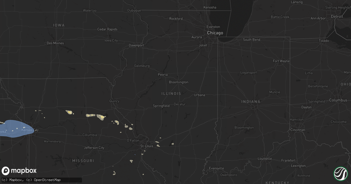
Hail Map in Illinois on July 16, 2024
Get this storm
July 16 map
$229
one time, instant access
Download today. No call, no setup
Keep the $229
Bought the map and want the full workflow? Apply the entire $229 to a subscription within 7 days. None of it is wasted.
Every map, not just this one
This buys you this map. Subscription and you get every map we run, in the markets you choose from a few cities to whole states to nationwide. Plus real-time alerts the moment a storm fires.
Contact data
Name, contact info, occupancy, even credit band for addresses in the footprint. You go from where it hit to who to call.
Become the source they trust
Unlimited branding weather history reports on demand. You already have the documented answer ready for the property owner, and you are the one who showed up with it.
Property data and RoofTrace estimates
Pull up any address you have got, its value and the exact code rules for that jurisdiction, straight from One Click Code. Then RoofTrace estimates the squares, pitch, and roof value, priced the way you price.
Storm reports in Illinois
Illinois
| Date | Description |
|---|---|
| 07/15/20249:02 PM CDT | A farm building suffered a partial collapse of walls and lost a large section of roofing materials. Time estimated by radar. |
| 07/15/20249:00 PM CDT | Snapped softwood trees and downed branches of hardwood trees in a relatively confined area. Time estimated by radar. |
| 07/15/20248:52 PM CDT | An nws storm survey in minonk determined the storm damage to be caused by straight-line winds of 85 to 95 mph. |
All States Impacted by Hail Map on July 16, 2024
Cities Impacted by Hail Map on July 16, 2024
- Ozawkie, KS
- Winchester, KS
- Hoyt, KS
- Holton, KS
- Oskaloosa, KS
- Denison, KS
- Meriden, KS
- Valley Falls, KS
- Nortonville, KS
- Topeka, KS
- Saint Marys, KS
- Rossville, KS
- Silver Lake, KS
- Maple Hill, KS
- Havensville, KS
- Onaga, KS
- Soldier, KS
- Belvue, KS
- Delia, KS
- Paxico, KS
- Emmett, KS
- Mayetta, KS
- Wamego, KS
- Lonedell, MO
- Dittmer, MO
- Richwoods, MO
- Edwardsville, IL
- Troy, IL
- Carlyle, IL
- Turney, MO
- Plattsburg, MO
- Tecumseh, KS
- Berryton, KS
- Grantville, KS
- Highland, IL
- Saint Jacob, IL
- Marine, IL
- Cameron, MO
- Cuba, MO
- De Soto, MO
- Alhambra, IL
- Lecompton, KS
- Perry, KS
- Lawrence, KS
- Trenton, IL
- Lebanon, IL
- Polo, MO
- Steelville, MO
- Wakarusa, KS
- Pocahontas, IL
- Rayville, MO
- Auburn, KS
- McLouth, KS
- Cook Sta, MO
- Salem, MO
- Imperial, MO
- Saint Louis, MO
- Tonganoxie, KS
- Easton, KS
- Atchison, KS
- Bonner Springs, KS
- Linwood, KS
- Leavenworth, KS
- Eudora, KS
- De Soto, KS
- Baldwin City, KS
- Basehor, KS
- Lenexa, KS
- Olathe, KS
- Kansas City, KS
- Sumner, MO
- Fletcher, MO
- Chillicothe, MO
- Arnold, MO
- Shawnee, KS
- Mendon, MO
- Rothville, MO
- Lansing, KS
- Riverside, MO
- Waldron, MO
- Farley, MO
- Platte City, MO
- Kansas City, MO
- Fort Leavenworth, KS
- Leawood, KS
- Prairie Village, KS
- Overland Park, KS
- Mission, KS
- Annada, MO
- Independence, MO
- Hamburg, IL
- Cairo, MO
- Moberly, MO
- Keytesville, MO
- Madison, MO
- Silex, MO
- Hawk Point, MO
- Jacksonville, MO
- Farmington, MO
- Curryville, MO
- Paris, MO
- Holliday, MO
- Osborn, MO
- Bowling Green, MO
- Santa Fe, MO
- Gasport, NY
- Stoutsville, MO
- Barker, NY
- Lyndonville, NY
- Middleport, NY
- Columbia, IL
- Perry, MO
- Eolia, MO
- Elsberry, MO
- Middletown, MO
- Vandalia, MO
- Foley, MO
- Cedar Hill, MO
- Millers Creek, NC
- Purlear, NC
- Theodore, AL
- Youngstown, FL
- Medina, NY
- Henderson, NY
- Henderson Harbor, NY
- Jordan, NY
- Weedsport, NY
- Cato, NY
- Watertown, NY
- Adams, NY
- Dexter, NY
- Adams Center, NY
- Sackets Harbor, NY
- The Villages, FL
- Fruitland Park, FL
- Memphis, NY
- Baldwinsville, NY
- Sumterville, FL
- Jamesville, NY
- Syracuse, NY
- Fayetteville, NY
- Jacksonville, FL
- Liverpool, NY
- Pennellville, NY
- Brewerton, NY
- Clay, NY
- Cicero, NY
- Kirkville, NY
- Chittenango, NY
- East Syracuse, NY
- Manlius, NY
- Minoa, NY
- Mallory, NY
- Central Square, NY
- West Monroe, NY
- Kannapolis, NC
- Rockwell, NC
- Constantia, NY
- Concord, NC
- Lisle, NY
- Berkshire, NY
- Richford, NY
- Covington, LA
- Folsom, LA
- Salisbury, NC
- Franklinton, LA
- Pavo, GA
- Lafayette, LA
- Rome, NY
- Three Mile Bay, NY
- Cape Vincent, NY
- Chaumont, NY
- La Fargeville, NY
- Evans Mills, NY
- Philadelphia, NY
- Fort Drum, NY
- Rodman, NY
- Belleville, NY
- Calcium, NY
- Ellisburg, NY
- Carthage, NY
- Sandy Creek, NY
- Brownville, NY
- Felts Mills, NY
- Mannsville, NY
- Black River, NY
- Natural Bridge, NY
- Harrisville, NY
- Wanakena, NY
- Croghan, NY
- Copenhagen, NY
- Lowville, NY
- Castorland, NY
- Lorraine, NY
- Waterloo, NY
- Montezuma, NY
- Lyons, NY
- Seneca Falls, NY
- Cayuga, NY
- North Rose, NY
- Sodus, NY
- Savannah, NY
- Auburn, NY
- Clyde, NY
- Port Byron, NY
- Wolcott, NY
- Sodus Point, NY
- Red Creek, NY
- Martville, NY
- Sterling, NY
- Skaneateles, NY
- Skaneateles Falls, NY
- Elbridge, NY
- Marcellus, NY
- Hannibal, NY
- Warners, NY
- Camillus, NY
- Nedrow, NY
- Fulton, NY
- Cazenovia, NY
- Phoenix, NY
- Canastota, NY
- Oneida, NY
- Bridgeport, NY
- Wampsville, NY
- Sherrill, NY
- Vernon, NY
- Vernon Center, NY
- Clinton, NY
- Whitesboro, NY
- Westmoreland, NY
- New York Mills, NY
- Utica, NY
- Durhamville, NY
- Verona, NY
- New Hartford, NY
- Verona Beach, NY
- Cleveland, NY
- Frankfort, NY
- Clark Mills, NY
- Quitman, GA
- Tylertown, MS
- Hickory, NC
- Luverne, AL
- Oswego, NY
- Bernhards Bay, NY
- Blossvale, NY
- Sylvan Beach, NY
- Oriskany, NY
- Yorkville, NY
- Camden, NY
- Hastings, NY
- North Bay, NY
- Taberg, NY
- Marcy, NY
- Stittville, NY
- Holland Patent, NY
- Lee Center, NY
- Westernville, NY
- Poland, NY
- Newport, NY
- Barneveld, NY
- Cold Brook, NY
- Remsen, NY
- Munnsville, NY
- Deansboro, NY
- Chadwicks, NY
- Sauquoit, NY
- Ilion, NY
- Prospect, NY
- Herkimer, NY
- Dolgeville, NY
- Salisbury Center, NY
- Mohawk, NY
- Little Falls, NY
- Middleville, NY
- Osteen, FL
- Warrior, AL
- Geneva, FL
- Bertrand, NE
- Bainbridge, NY
- Mount Upton, NY
- Unadilla, NY
- Oviedo, FL
- Eustis, NE
- Huntsville, AL
- Wallace, WV
- Hoffmeister, NY
- Saint Johnsville, NY
- Stratford, NY
- Johnstown, NY
- Caroga Lake, NY
- Gloversville, NY
- Mayfield, NY
- Piseco, NY
- Wells, NY
- Northville, NY
- Lake Pleasant, NY
- Cambridge, NE
- Oxford, NE
- Pueblo, CO
- Valentine, NE
- Stony Creek, NY
- Corinth, NY
- Hadley, NY
- Johnsburg, NY
- Broadalbin, NY
- Galway, NY
- Middle Grove, NY
- Greenfield Center, NY
- Lake Luzerne, NY
- Porter Corners, NY
- Warnerville, NY
- Johnstown, NE
- Mims, FL
- Pamplico, SC
- Effingham, SC
- Evans, GA
- Saint Cloud, FL
- Wilcox, NE
- Holdrege, NE
- Ainsworth, NE
- Oberon, ND
- Sheyenne, ND
- Hendley, NE
- Oley, PA
- Republican City, NE
- Naponee, NE
- Schoharie, NY
- Hazel Green, KY
- Middleburgh, NY
- Holbrook, NE
- Hildreth, NE
- Alma, NE
- Fort Plain, NY
- Fonda, NY
- Tribes Hill, NY
- Amsterdam, NY
- Fort Johnson, NY
- Hagaman, NY
- Fultonville, NY
- Fort Hunter, NY
- Ballston Spa, NY
- Rock City Falls, NY
- Rotterdam Junction, NY
- Schenectady, NY
- Pattersonville, NY
- Ballston Lake, NY
- Clifton Park, NY
- Saratoga Springs, NY
- Alplaus, NY
- Rexford, NY
- Burnt Hills, NY
- Chestertown, NY
- Athol, NY
- Warrensburg, NY
- Bolton Landing, NY
- Lake George, NY
- Diamond Point, NY
- Queensbury, NY
- Troy, NY
- Stillwater, NY
- Schuylerville, NY
- Cohoes, NY
- South Glens Falls, NY
- Schaghticoke, NY
- Round Lake, NY
- Fort Edward, NY
- Glens Falls, NY
- Mechanicville, NY
- Waterford, NY
- Melrose, NY
- Gansevoort, NY
- Boone, CO
- Avondale, CO
- Greensboro, AL
- Gallion, AL
- Camden, AL
- New Brockton, AL
- Enterprise, AL
- Mize, KY
- New Rockford, ND
- Altamont, NY
- Berne, NY
- Delanson, NY
- East Berne, NY
- Clanton, AL
- Elba, AL
- Show Low, AZ
- Norton, KS
- Kensington, KS
- Agra, KS
- Bloomington, NE
- Thedford, NE
- Fordland, MO
- Hellertown, PA
- Wilsonville, NE
- Beaver City, NE
- Quakertown, PA
- Kintnersville, PA
- Wood Lake, NE
- Beatrice, AL
- West Stockbridge, MA
- Austerlitz, NY
- Guilderland, NY
- Voorheesville, NY
- Johnsonville, SC
- Hemingway, SC
- Hudson Falls, NY
- Fort Ann, NY
- Cropseyville, NY
- Petersburg, NY
- Latham, NY
- Hampton, NY
- Comstock, NY
- Eagle Bridge, NY
- Valley Falls, NY
- Victory Mills, NY
- Granville, NY
- Greenwich, NY
- Argyle, NY
- Huletts Landing, NY
- Buskirk, NY
- Cossayuna, NY
- Cambridge, NY
- Kattskill Bay, NY
- Middle Granville, NY
- Hartford, NY
- North Pownal, VT
- North Bennington, VT
- North Granville, NY
- Shushan, NY
- Johnsonville, NY
- Whitehall, NY
- Fair Haven, VT
- Salem, NY
- Hague, NY
- Clemons, NY
- Hoosick Falls, NY
- Albany, NY
- Pine Apple, AL
- Newton, NJ
- Augusta, NJ
- Branchville, NJ
- Lafayette, NJ
- Sussex, NJ
- Weogufka, AL
- Lenox, MA
- Richmond, MA
- Slingerlands, NY
- Ottsville, PA
- Sugar City, CO
- Pittsfield, MA
- Birdsboro, PA
- Douglassville, PA
- Lake City, SC
- Stamford, NE
- Duanesburg, NY
- East Schodack, NY
- Wynantskill, NY
- Delmar, NY
- Coeymans, NY
- Malden Bridge, NY
- Sand Lake, NY
- Averill Park, NY
- Brainard, NY
- Selkirk, NY
- Niverville, NY
- Feura Bush, NY
- Schodack Landing, NY
- Watervliet, NY
- East Chatham, NY
- Ravena, NY
- Stephentown, NY
- West Sand Lake, NY
- South Bethlehem, NY
- East Greenbush, NY
- East Nassau, NY
- Nassau, NY
- Old Chatham, NY
- Kinderhook, NY
- Valatie, NY
- Castleton On Hudson, NY
- Stuyvesant, NY
- Poestenkill, NY
- Rensselaer, NY
- West Coxsackie, NY
- Glenmont, NY
- New Lebanon, NY
- Williamstown, MA
- Berlin, NY
- Pownal, VT
- Center Rutland, VT
- Poultney, VT
- Shaftsbury, VT
- West Pawlet, VT
- Manchester, VT
- Proctor, VT
- Danby, VT
- Bondville, VT
- Cuttingsville, VT
- Wells, VT
- Arlington, VT
- East Arlington, VT
- East Wallingford, VT
- Peru, VT
- Manchester Center, VT
- Dorset, VT
- Middletown Springs, VT
- Wallingford, VT
- Castleton, VT
- East Dorset, VT
- Bennington, VT
- West Rupert, VT
- West Rutland, VT
- Londonderry, VT
- Rutland, VT
- Pawlet, VT
- Belmont, VT
- North Clarendon, VT
- Bomoseen, VT
- Mount Holly, VT
- Stapleton, NE
- Jack, AL
- Vredenburgh, AL
- Hamburg, NJ
- Lenora, KS
- Logan, KS
- Almena, KS
- Frenchtown, NJ
- Pittstown, NJ
- Ringoes, NJ
- Stockton, NJ
- Flemington, NJ
- Three Bridges, NJ
- Neshanic Station, NJ
- Hillsborough, NJ
- Vernon, NJ
- Hewitt, NJ
- Glenwood, NJ
- Greenwood Lake, NY
- Highland Lakes, NJ
- Warwick, NY
- Monroe, NY
- Tuxedo Park, NY
- Chester, NY
- Harriman, NY
- Long Pine, NE
- Kenton, OK
- Tryon, NE
- Hinsdale, MA
- Windsor, MA
- Dalton, MA
- Rockford, AL
- Yellville, AR
- Boise City, OK
- Bassett, NE
- Maxwell, NE
- Higgins, TX
- Brewster, NE
- Cummington, MA
- Lanesborough, MA
- La Junta, CO
- Brady, NE
- Arnold, NE
- Purdum, NE
- Cavendish, VT
- Wardsboro, VT
- Jamaica, VT
- Stamford, VT
- Brownsville, VT
- Florence, VT
- Weston, VT
- Plainfield, NH
- South Woodstock, VT
- Bridgewater, VT
- West Dover, VT
- Wilmington, VT
- West Wardsboro, VT
- South Londonderry, VT
- Ludlow, VT
- Woodstock, VT
- Perkinsville, VT
- Proctorsville, VT
- Bridgewater Corners, VT
- Reading, VT
- Windsor, VT
- Hartland, VT
- Killington, VT
- Plymouth, VT
- Cornish, NH
- Springfield, VT
- West Townshend, VT
- Chester, VT
- North Springfield, VT
- North Hartland, VT
- Saxtons River, VT
- Williamsville, VT
- Monroe Bridge, MA
- Shelburne Falls, MA
- North Walpole, NH
- Chesterfield, NH
- East Dover, VT
- Savoy, MA
- Bellows Falls, VT
- Ascutney, VT
- Jacksonville, VT
- Putney, VT
- Charlemont, MA
- Readsboro, VT
- Whitingham, VT
- Adams, MA
- Bernardston, MA
- South Newfane, VT
- Buckland, MA
- Cambridgeport, VT
- Drury, MA
- Colrain, MA
- Alstead, NH
- Westminster, VT
- Walpole, NH
- Turners Falls, MA
- Claremont, NH
- Newfane, VT
- North Adams, MA
- Heath, MA
- West Chesterfield, NH
- Brattleboro, VT
- Rowe, MA
- Westmoreland, NH
- Grafton, VT
- Greenfield, MA
- Hinsdale, NH
- Meriden, NH
- Charlestown, NH
- Vernon, VT
- Townshend, VT
- West Halifax, VT
- Canaan, NY
- Cheshire, MA
- Easthampton, MA
- Williamsburg, MA
- Ashfield, MA
- Deerfield, MA
- Goshen, MA
- Becket, MA
- Huntington, MA
- Haydenville, MA
- Chesterfield, MA
- West Chesterfield, MA
- South Deerfield, MA
- Chester, MA
- Middlefield, MA
- Worthington, MA
- Plainfield, MA
- Berkshire, MA
- Conway, MA
- Bogue, KS
- Canadian, TX
- Kim, CO
- Independence, LA
- Elsmere, NE
- Horseshoe Bend, AR
- Oxford, AR
- Violet Hill, AR
- Wiseman, AR
- Ravenden, AR
- Williford, AR
- Las Animas, CO
- Brockwell, AR
- Asheville, NC
- Bethlehem, PA
- Center Valley, PA
- Summit, AR
- York, PA
- Taylor, NE
- Macungie, PA
- Emmaus, PA
- Allentown, PA
- Harriet, AR
- Morganton, NC
- Sidney, NY
- Peterman, AL
- Holden, LA
- Durham, OK
- Arnett, OK
- Mount Joy, PA
- Manheim, PA
- Anselmo, NE
- Dunning, NE
- Saint Joe, AR
- Lititz, PA
- Flippin, AR
- Manchester, PA
- Mount Wolf, PA
- Dover, PA
- Emigsville, PA
- Salem, AR
- Franklin, AR
- Bull Shoals, AR
- Coopersburg, PA
- Saint George, SC
- Lakeview, AR
- Northampton, MA
- Fitzwilliam, NH
- Leverett, MA
- Sullivan, NH
- Gill, MA
- Spofford, NH
- Keene, NH
- Marlborough, NH
- South Acworth, NH
- Templeton, MA
- Dublin, NH
- Hatfield, MA
- Montague, MA
- Gardner, MA
- Troy, NH
- Nelson, NH
- West Hatfield, MA
- Millers Falls, MA
- Royalston, MA
- Orange, MA
- New Salem, MA
- Athol, MA
- Rindge, NH
- Winchester, NH
- Amherst, MA
- Stoddard, NH
- Newport, NH
- Florence, MA
- Northfield, MA
- Wendell, MA
- Petersham, MA
- Swanzey, NH
- Wendell Depot, MA
- North Hatfield, MA
- Leeds, MA
- Shutesbury, MA
- Jaffrey, NH
- Erving, MA
- Lake Pleasant, MA
- Harrisville, NH
- Washington, NH
- Baldwinville, MA
- Sunderland, MA
- Winchendon, MA
- Marlow, NH
- Lempster, NH
- Ashuelot, NH
- Acworth, NH
- Warwick, MA
- Hadley, MA
- Gilsum, NH
- Bennington, NH
- Franklin, NH
- Bradford, NH
- New London, NH
- Grafton, NH
- Enfield, NH
- Greenfield, NH
- Hillsborough, NH
- Francestown, NH
- Canterbury, NH
- New Ipswich, NH
- North Sutton, NH
- Concord, NH
- Contoocook, NH
- Wilmot, NH
- Peterborough, NH
- Sanbornton, NH
- Newbury, NH
- Hill, NH
- Andover, NH
- Georges Mills, NH
- Sunapee, NH
- Tilton, NH
- Springfield, NH
- Antrim, NH
- Danbury, NH
- Salisbury, NH
- South Sutton, NH
- Grantham, NH
- Goshen, NH
- Elkins, NH
- Hancock, NH
- Ashburnham, MA
- Weare, NH
- Temple, NH
- Henniker, NH
- Warner, NH
- Belmont, NH
- Lyndeborough, NH
- Bow, NH
- Dunbarton, NH
- Wilton, NH
- New Boston, NH
- Sandisfield, MA
- Lenox Dale, MA
- Stockbridge, MA
- Otis, MA
- Lee, MA
- Monterey, MA
- Blandford, MA
- South Lee, MA
- Tyringham, MA
- Chatham, NY
- Housatonic, MA
- Great Barrington, MA
- Spencertown, NY
- Marion, AL
- Monroeville, AL
- Springfield, CO
- Bowman, SC
- Marshall, AR
- Branchville, SC
- Broken Bow, NE
- Calico Rock, AR
- Maytown, PA
- Marietta, PA
- Hanover, PA
- McSherrystown, PA
- Mountain Home, AR
- Midway, AR
- Poughkeepsie, AR
- Evening Shade, AR
- Amarillo, TX
- Merna, NE
- Ephrata, PA
- Big Flat, AR
- Ovett, MS
- Taloga, OK
- Moorefield, NE
- Ansley, NE
- Pittsfield, NH
- Center Barnstead, NH
- Gilmanton, NH
- Gilmanton Iron Works, NH
- Loudon, NH
- Chichester, NH
- Barnstead, NH
- Candia, NH
- Epsom, NH
- Raymond, NH
- Hooksett, NH
- Deerfield, NH
- Northwood, NH
- Suncook, NH
- Strafford, NH
- West Townsend, MA
- Brookline, NH
- Mont Vernon, NH
- Merrimack, NH
- Derry, NH
- Londonderry, NH
- Chester, NH
- Greenville, NH
- Manchester, NH
- Goffstown, NH
- Bedford, NH
- Milford, NH
- Auburn, NH
- Amherst, NH
- Hollis, NH
- Ashby, MA
- Litchfield, NH
- Fitchburg, MA
- Westminster, MA
- Dunstable, MA
- Groton, MA
- Nashua, NH
- Tyngsboro, MA
- Windham, NH
- Lunenburg, MA
- Pepperell, MA
- Hudson, NH
- Pelham, NH
- Townsend, MA
- Belchertown, MA
- Granby, MA
- Hubbardston, MA
- Ware, MA
- South Hadley, MA
- Barre, MA
- Hardwick, MA
- Southampton, MA
- East Otis, MA
- Russell, MA
- Westfield, MA
- Holyoke, MA
- Crawford, OK
- Smithville, AR
- Hydro, OK
- Keyes, OK
- Goodwell, OK
- Pampa, TX
- Stockton, KS
- Colony, OK
- Cordell, OK
- Gamaliel, AR
- Clarkridge, AR
- Fifty Six, AR
- Weatherford, OK
- Corn, OK
- Onia, AR
- Damar, KS
- Gilbert, AR
- Littlestown, PA
- Black Rock, AR
- Ash Flat, AR
- Red Lion, PA
- Narvon, PA
- Honey Brook, PA
- Elkhart, KS
- Spring Grove, PA
- Custer City, OK
- Sage, AR
- Oconto, NE
- Eddyville, NE
- Sumner, NE
- Overton, NE
- Mountain View, AR
- Coatesville, PA
- Parkesburg, PA
- Gap, PA
- Elkins Park, PA
- Philadelphia, PA
- Cheltenham, PA
- Huntingdon Valley, PA
- Willow Grove, PA
- Paradise, PA
- Kinzers, PA
- Christiana, PA
- Quarryville, PA
- Atglen, PA
- Meridian, MS
- Perryton, TX
- Burlington, CO
- Callaway, NE
- Mason City, NE
- Newmarket, NH
- Rochester, NH
- Epping, NH
- Lee, NH
- Barrington, NH
- West Nottingham, NH
- Nottingham, NH
- Newton, NH
- Dracut, MA
- Kingston, NH
- Merrimac, MA
- Methuen, MA
- Danville, NH
- Atkinson, NH
- Lowell, MA
- Salem, NH
- Newfields, NH
- North Chelmsford, MA
- Hampstead, NH
- Haverhill, MA
- Exeter, NH
- Fremont, NH
- Sandown, NH
- East Kingston, NH
- Plaistow, NH
- East Hampstead, NH
- Lancaster, MA
- Oakham, MA
- Sterling, MA
- Berlin, MA
- Hudson, MA
- Jefferson, MA
- Stow, MA
- Devens, MA
- Bolton, MA
- Westford, MA
- Holden, MA
- Rutland, MA
- Littleton, MA
- South Barre, MA
- Acton, MA
- Clinton, MA
- New Braintree, MA
- Gilbertville, MA
- Leominster, MA
- Shirley, MA
- Boylston, MA
- Ayer, MA
- West Boylston, MA
- Princeton, MA
- Boxborough, MA
- Harvard, MA
- Kendall, KS
- Syracuse, KS
- Jenkintown, PA
- Arapahoe, CO
- Timbo, AR
- Elm Creek, NE
- Vici, OK
- Lincoln University, PA
- Cochranville, PA
- West Grove, PA
- Avondale, PA
- Toughkenamon, PA
- Landenberg, PA
- Kennett Square, PA
- Grinnell, KS
- Spearville, KS
- Hanston, KS
- Jetmore, KS
- Dalhart, TX
- Booker, TX
- Bridgeport, NJ
- Chester, PA
- Swedesboro, NJ
- Elkton, MD
- Camden, NJ
- Oaklyn, NJ
- Texhoma, OK
- Funk, NE
- Tribune, KS
- Glencoe, AR
- Ford, KS
- Clarksboro, NJ
- Mount Royal, NJ
- Newark, DE
- Elk Mills, MD
- Pineville, AR
- Shamrock, TX
- Oxford, PA
- Audubon, NJ
- Gloucester City, NJ
- Mount Ephraim, NJ
- Sharon, OK
- Gibbstown, NJ
- Mickleton, NJ
- Pine, AZ
- Sidney, AR
- Edgemont, AR
- North East, MD
- Briscoe, TX
- Panhandle, TX
- Mantua, NJ
- Paulsboro, NJ
- Thorofare, NJ
- Drasco, AR
- Prim, AR
- Mullica Hill, NJ
- Higden, AR
- Cave City, AR
- Melbourne, AR
- Camargo, OK
- Stratford, TX
- Texhoma, TX
- Batesville, AR
- Mutual, OK
- Mountain View, OK
- Curtis, NE
- Bucklin, KS
- Woodward, OK
- Wright, KS
- Scott City, KS
- Healy, KS
- Davisboro, GA
- Bartow, GA
- Mooreland, OK
- Chester, OK
- Gruver, TX
- Borger, TX
- Stinnett, TX
- Lexington, NE
- Lamar, CO
- Campo, CO
- Pritchett, CO
- Holly, CO
- Two Buttes, CO
- Johnson, KS
- Manter, KS
- Walsh, CO
- Vilas, CO
- Lakin, KS
- Granada, CO
- Rolla, KS
- Guymon, OK
- Richfield, KS
- Copeland, KS
- Satanta, KS
- Sublette, KS
- Holcomb, KS
- Montezuma, KS
- Kismet, KS
- Hooker, OK
- Pierceville, KS
- Ingalls, KS
- Garden City, KS
- Moscow, KS
- Ulysses, KS
- Liberal, KS
- Cimarron, KS
- Hugoton, KS
- Deerfield, KS
- Beaver, OK
- Plains, KS
- Forgan, OK
- Turpin, OK
- Balko, OK
- Hardesty, OK
- Tyrone, OK
- Minneola, KS
- Wadley, GA
- Western Grove, AR
- Warwick, MD
- Earleville, MD
- Morse, TX
- Magness, AR
- Loomis, NE
- Kinsley, KS
- Cecilton, MD
- Kennedyville, MD
- Mount Judea, AR
- Fowler, KS
- Centreville, MD
- Rock Hall, MD
- Axtell, NE
- Fairview, OK
- Ensign, KS
- Spearman, TX
- Ingleside, MD
- Sudlersville, MD
- Barclay, MD
- Church Hill, MD
- Heber Springs, AR
- Chestertown, MD
- Meade, KS
- Cotter, AR
- Gassville, AR
- Lebanon Junction, KY
- Dover, DE
- Smyrna, DE
- Clayton, DE
- Queen Anne, MD
- Gage, OK
- Fargo, OK
- Shirley, AR
- Amesbury, MA
- Maynard, MA
- Canton, OK
- Longdale, OK
- Goldsboro, MD
- Henderson, MD
- Perryville, MO
- Englewood, KS
- Camden Wyoming, DE
- Wolf Lake, IL
- Laverne, OK
- Ashland, KS
- Follett, TX
- North Platte, NE
- Leslie, AR
- Dennard, AR
- Rosston, OK
- Norfork, AR
- Watonga, OK
- Shattuck, OK
- Waynoka, OK
- Hitchcock, OK
- Witts Springs, AR
- Hunter, OK
- Dodge City, KS
- Buffalo, OK
- Viola, DE
- Magnolia, DE
- Felton, DE
- Frederica, DE
- Okeene, OK
- Ridgely, MD
- Dover Afb, DE
- Landisville, PA
- Jonesboro, IL
- Quitman, AR
- Willcox, AZ
- Milford, DE
- Omega, OK
- Fort Supply, OK
- Stillwater, OK
- Perry, OK
- Kingfisher, OK
- Springfield, GA
- Monroe, NC
- San Simon, AZ
- Bowie, AZ
- Stroud, OK
- Greenbrier, AR
- Animas, NM
- Sunray, TX
- Cushing, OK
- Protection, KS
- Alva, OK
- Henderson, NC
- Offerle, KS
- Ripley, OK
- Burlington, OK
- Amorita, OK
- Guyton, GA
- Gate, OK
- May, OK
- Atkins, AR
- Wakita, OK
- Cherokee, OK
- Freedom, OK
- Perkins, OK
- Greensburg, KS
- Coldwater, KS
- Haviland, KS
- Seiling, OK
- Anthony, KS
- Freeport, KS
- Lake City, KS
- Nash, OK
- Sturkie, AR
- Medford, OK
- Bluff City, KS
- Caldwell, KS
- Nardin, OK
- Sun City, KS
- Kiowa, KS
- Coats, KS
- Medicine Lodge, KS
- Milan, KS
- Waldron, KS
- Blackwell, OK
- Hardtner, KS
- Harper, KS
- Attica, KS
- Sharon, KS
- Newkirk, OK
- Mayfield, KS
- Ponca City, OK
- Wellington, KS
- Isabel, KS
- Pawhuska, OK
- Wynona, OK
- Nashville, KS
- Oxford, KS
- Winfield, KS
- Bartlesville, OK
- Shidler, OK
- Arkansas City, KS
- Maple City, KS
- Burden, KS
- Peel, AR
- Cedarcreek, MO
- Protem, MO
- Lead Hill, AR
- Dewey, OK
- Dexter, KS
- Cedar Vale, KS
- Cambridge, KS
- Peru, KS
- Sedan, KS
- Omaha, AR
- Copan, OK
- Wann, OK
- Lenapah, OK
- Moline, KS
- Miami, OK
- Caney, KS
- Vinita, OK
- Rogersville, MO
- Welch, OK
- Edna, KS
- Coffeyville, KS
- S Coffeyville, OK
- Chetopa, KS
- Neosho, MO
- Granby, MO
- Baxter Springs, KS
- Quapaw, OK
- Mound Valley, KS
- Sarcoxie, MO
- Diamond, MO
- Altamont, KS
- Oswego, KS
- Pierce City, MO
- Galena, KS
- Red Oak, OK
- Joplin, MO
- Duenweg, MO
- La Russell, MO
- Stotts City, MO
- Shady Point, OK
- Wister, OK
- Webb City, MO
- Oronogo, MO
- Mount Vernon, MO
- Verona, MO
- Bruner, MO
- Republic, MO
- Billings, MO
- Nixa, MO
- Sparta, MO
- Ozark, MO
- Springfield, MO
- Brookline, MO
- Clever, MO
- Cartersville, GA
- Walling, TN
- White, GA
- Strafford, MO
- El Reno, OK
- Kearney, NE
- Riverdale, NE
- Amherst, NE
- Stennis Space Center, MS
- Lyme, NH
- Ava, NY
- Plymouth, NY
- Georgetown, NY
- North Pitcher, NY
- South Otselic, NY
- Cortland, NY
- Dryden, NY


