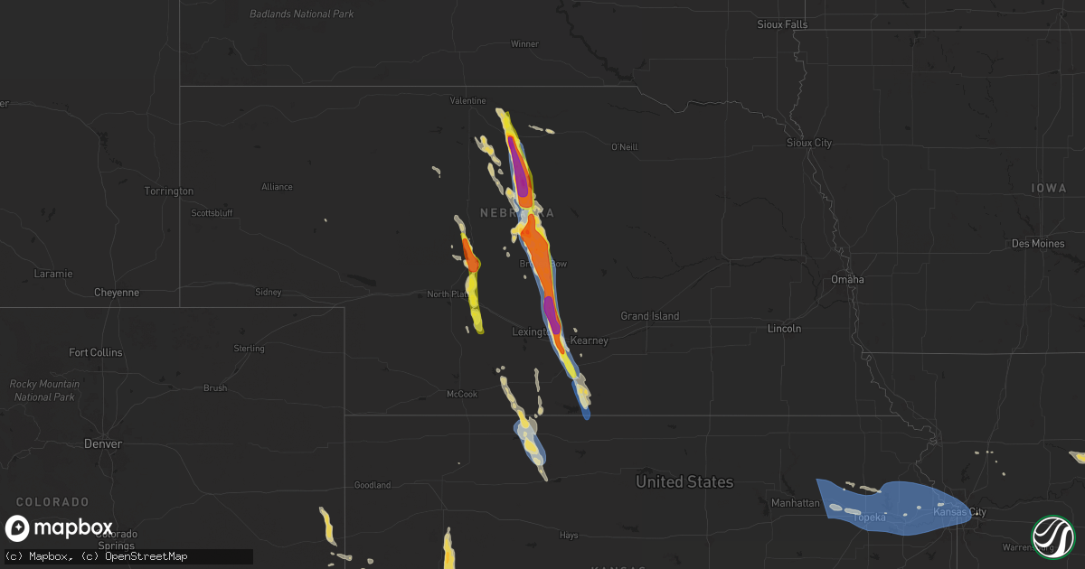
Hail Map on July 16, 2024
Get this storm
July 16 map
$229
one time, instant access
Download today. No call, no setup
Keep the $229
Bought the map and want the full workflow? Apply the entire $229 to a subscription within 7 days. None of it is wasted.
Every map, not just this one
This buys you this map. Subscription and you get every map we run, in the markets you choose from a few cities to whole states to nationwide. Plus real-time alerts the moment a storm fires.
Contact data
Name, contact info, occupancy, even credit band for addresses in the footprint. You go from where it hit to who to call.
Become the source they trust
Unlimited branding weather history reports on demand. You already have the documented answer ready for the property owner, and you are the one who showed up with it.
Property data and RoofTrace estimates
Pull up any address you have got, its value and the exact code rules for that jurisdiction, straight from One Click Code. Then RoofTrace estimates the squares, pitch, and roof value, priced the way you price.
States Impacted by Hail Map on July 16, 2024
Storm reports
Illinois
| Date | Description |
|---|---|
| 07/15/20249:02 PM CDT | A farm building suffered a partial collapse of walls and lost a large section of roofing materials. Time estimated by radar. |
| 07/15/20249:00 PM CDT | Snapped softwood trees and downed branches of hardwood trees in a relatively confined area. Time estimated by radar. |
| 07/15/20248:52 PM CDT | An nws storm survey in minonk determined the storm damage to be caused by straight-line winds of 85 to 95 mph. |
Mississippi
| Date | Description |
|---|---|
| 07/16/20244:20 PM CDT | Tree down blocking road at stennis. Time estimated from radar. |
| 07/16/20244:18 PM CDT | Delayed. Picture of hail estimated to be about quarter size north of gainesville... Ms near stennis space center. |
West Virginia
| Date | Description |
|---|---|
| 07/16/20244:31 PM CDT | Trees fell on a house in harts... Destroying it. |
| 07/16/20243:30 PM CDT | Spotter and county 911 report a tree down on state route 20 east of diana. |
| 07/16/20243:25 PM CDT | Power outage caused by downed tree reported along blue creek road. |
| 07/16/20243:10 PM CDT | County 911 reports a tree down on ashford nellis road. |
| 07/16/20242:50 PM CDT | County 911 reports a tree down on turkey creek road near good hope church. |
| 07/16/20242:30 PM CDT | Power outage caused by downed tree reported by utility company. |
| 07/16/20242:15 PM CDT | County 911 reports tree down near scott depot... North of the interstate. |
| 07/16/20242:15 PM CDT | County 911 reports tree down near scott depot... North of the interstate. |
Louisiana
| Date | Description |
|---|---|
| 07/16/20242:36 PM CDT | Downed power line reported by sheriffs office in franklinton. |
Vermont
| Date | Description |
|---|---|
| 07/16/20246:10 PM CDT | Numerous large branches at least 6 inches in diameter on some roads and took down power lines. |
| 07/16/20245:47 PM CDT | Estimated more than two dozen trees down. Many were uprooted or snapped. Time estimated from radar. |
| 07/16/20245:45 PM CDT | Trees down throughout townshend. Time estimated. |
| 07/16/20245:30 PM CDT | Photos of tree damage in springfield. Time estimated based on radar. |
| 07/16/20245:27 PM CDT | Reported trees and utility lines down in the town of stamford between clayton ave and clough rd along vt-8 and 100. Time estimated by radar. |
| 07/16/20245:18 PM CDT | Vt rt 11w by andover rd closed due to powerlines down across roadway. Time estimated based on radar. |
| 07/16/20244:54 PM CDT | Tree reported down by broadcast media. Time estimated based on radar. |
| 07/16/20244:47 PM CDT | Estimated more than two dozen trees down. Many were uprooted or snapped. Time estimated from radar. |
| 07/16/20244:45 PM CDT | A tree was downed on vermont route 30 in the town of dorset. |
Connecticut
| Date | Description |
|---|---|
| 07/15/20249:00 PM CDT | In dayville... Trees were down on putnam pike. Relayed by amateur radio. |
| 07/15/20248:50 PM CDT | In pomfret... A very large tree limb 20 inches in diameter was down on kearney rd bringing down wires. Several other large limbs 5 inches in diameter were down on amber |
| 07/15/20248:30 PM CDT | In ashford... A tree and wires were down on slade rd. Relayed by amateur radio. |
| 07/15/20248:20 PM CDT | In west hartford... There were multiple reports of trees and wires down including on timber ln. |
Maine
| Date | Description |
|---|---|
| 07/15/20248:29 PM CDT | Trees down near junction of payne road and rt 1. |
| 07/15/20248:00 PM CDT | Trees and wires down. |
| 07/15/20247:46 PM CDT | A local report indicates 58 MPH wind near Sanford Seacoast Region |
Nebraska
| Date | Description |
|---|---|
| 07/16/20246:55 PM CDT | Delayed report via ambient weather network. |
| 07/16/20246:54 PM CDT | A local report indicates a tornado near 3 SE Merna |
| 07/16/20246:40 PM CDT | A local report indicates 1.75 inch wind near 3 N Anselmo |
| 07/16/20246:25 PM CDT | A local report indicates 1.00 inch wind near 6 ENE Anselmo |
| 07/16/20246:18 PM CDT | Quarter size hail covering the ground. |
| 07/16/20246:18 PM CDT | A local report indicates 1.25 inch wind near 1 E Maxwell |
| 07/16/20245:50 PM CDT | Tansformer pole broke off and cattle truck blown over on highway 91. Time estimated by radar. |
| 07/16/20245:25 PM CDT | A local report indicates 60 MPH wind near 15 N Brewster |
| 07/16/20245:25 PM CDT | A local report indicates 1.75 inch wind near 15 N Brewster |
| 07/16/20245:15 PM CDT | Powerlines down... Broken windows... And trees down. |
| 07/16/20245:08 PM CDT | Delayed report via ambient weather network. |
| 07/16/20244:55 PM CDT | Accompanied by 60 mph winds. |
| 07/16/20244:55 PM CDT | A local report indicates 60 MPH wind near 14 NNW Stapleton |
| 07/16/20244:32 PM CDT | Hail lasted for 10 minutes. |
| 07/16/20244:25 PM CDT | A local report indicates 1.25 inch wind near 2 ESE Johnstown |
| 07/16/20244:23 PM CDT | Estimated winds to at least 60 mph caused at least minor tree damage. Also reports of power outages in the area. |
| 07/16/20244:17 PM CDT | Social media r pa 4054 7517 em reports numerous trees and wires down in nockamixon township. Some utility poles were snapped at ground level. Time estimated from radar. |
| 07/16/20244:17 PM CDT | Social media report of 3 snapped power poles. |
| 07/16/20243:55 PM CDT | A local report indicates 66 MPH wind near 7 ENE Huntley |
| 07/15/20249:05 PM CDT | Photo relayed via social media. Power pole snapped about halfway up and lots of tree damage. Heavy rain and very strong winds were also reported. Time estimated from ra |
| 07/15/20248:55 PM CDT | A local report indicates 64 MPH wind near Holdrege Airport |
| 07/15/20248:52 PM CDT | Wl-holdrege4.88nnw. |
| 07/15/20248:51 PM CDT | A local report indicates 59 MPH wind near 4 N Holdrege |
| 07/15/20248:49 PM CDT | Wl-holdrege5.87n. |
| 07/15/20248:41 PM CDT | In addition to the flipped irrigation pivot near hwy 183 and 744 road... Severe crop damage from wind driven quarter to half dollar size hail. |
| 07/15/20248:41 PM CDT | Flipped irrigation pivot near hwy 183 and 744 road. Severe crop damage. |
| 07/15/20248:38 PM CDT | A local report indicates 62 MPH wind near 8 S Elm Creek |
| 07/15/20248:31 PM CDT | A local report indicates 58 MPH wind near 5 SSW Elm Creek |
| 07/15/20248:23 PM CDT | A local report indicates 70 MPH wind near 3 W Elm Creek |
| 07/15/20248:18 PM CDT | A local report indicates 60 MPH wind near 2 ESE Overton |
| 07/15/20248:13 PM CDT | A local report indicates 60 MPH wind near 3 N Overton |
| 07/15/20248:05 PM CDT | Public report of golf ball size hail. Location estimated to be near the dawson and buffalo county line between sumner and elm creek. |
| 07/15/20248:00 PM CDT | A local report indicates 65 MPH wind near 4 SE Eddyville |
| 07/15/20248:00 PM CDT | A local report indicates 65 MPH wind near 4 SE Eddyville |
| 07/15/20247:56 PM CDT | A local report indicates 1.00 inch wind near 3 WNW Sumner |
| 07/15/20247:52 PM CDT | A local report indicates 59 MPH wind near 4 NNW Sumner |
| 07/15/20247:45 PM CDT | Few gusts estimated to be at least 60 mph. |
| 07/15/20247:30 PM CDT | A local report indicates 1.00 inch wind near 10 SSW Berwyn |
Oregon
| Date | Description |
|---|---|
| 07/16/20246:25 PM CDT | 15 large pine trees of 1 to 2 ft diamter snapped. |
| 07/16/20246:05 PM CDT | Tree down...estimated to be 3.5-4 ft in diameter. |
| 07/15/202410:05 PM CDT | Spotter reported 4 large trees down... With gusts estimated up to 55mph. Power was also reported to have gone out around 1950 pdt. |
| 07/15/20249:34 PM CDT | Report from mping: 1-inch tree limbs broken; shingles blown off. |
New Jersey
| Date | Description |
|---|---|
| 07/16/20246:18 PM CDT | Sandy hook... Nj |
| 07/16/20245:48 PM CDT | Downed tree on nj 27 both directions north of cr 614/pearl st |
| 07/16/20245:47 PM CDT | Large tree uprooted leaning on a house along harmon rd near edison. Time estimated. |
| 07/16/20245:46 PM CDT | Numerous trees and branches down in fords... Nj. Time estimated by radar. |
| 07/16/20245:46 PM CDT | Nj dot - stmc: downed tree on us 1 southbound north of grandview av |
| 07/16/20245:45 PM CDT | Trees down in woodgridge. |
| 07/16/20245:45 PM CDT | Numerous trees either uprooted or snapped in roosevelt park in edison. Time estimated. |
| 07/16/20245:27 PM CDT | Downed tree on us 22 westbound glenside av |
| 07/16/20245:05 PM CDT | Multiple trees down on a house with people trapped inside on clover hill rd. No injuries at time of report. Time estimated from radar. |
| 07/16/20245:05 PM CDT | Trained spotter relays measured wind gust on pws of 61.2mph. |
| 07/16/20245:05 PM CDT | Large branches down. |
| 07/16/20245:05 PM CDT | Large branches cheshire nh 4294 7228 trees and wires down on pine street. |
| 07/16/20245:01 PM CDT | Numerous trees down on voorhees corner rd passed along by em. Time estimated. |
| 07/16/20245:00 PM CDT | Njwxnet: pittstown gusted to 61 mph. |
| 07/16/20245:00 PM CDT | Trees down in whitehouse station. |
| 07/16/20244:59 PM CDT | Em relays report of tree on top of a car with a person trapped inside. No injuries at time of report. Time estimated from radar. |
| 07/16/20244:57 PM CDT | Tree down on house in vernon twp... Nj. Time estimated by radar. |
| 07/16/20244:52 PM CDT | Numerous tree limbs and branches down in sussex... Nj. Time estimated by radar. |
| 07/16/20244:48 PM CDT | Nj dot - stmc: downed tree on nj 173 eastbound nj 173 |
| 07/16/20244:48 PM CDT | Nj dot - stmc: ma 4256 7316 several trees down in the town of cheshire. Time estimated from radar. |
| 07/16/20244:45 PM CDT | Nj dot - stmc: downed pole and downed tree on nj 29 both directions south of washington st |
| 07/16/20244:45 PM CDT | Em relays report of extensive tree damage in frenchtown. Will pass along more information when known. Time estimated from radar. |
| 07/16/20244:44 PM CDT | Numerous trees a wires down across the county from frankford twp... To sussex... To vernon twp. |
| 07/15/202410:41 PM CDT | Report of a tree down in commercial township. Time estimated. |
| 07/15/202410:04 PM CDT | Report of trees down on wires in upper elsinboro township. Time estimated. |
| 07/15/20249:14 PM CDT | Tree limbs fell onto a vehicle on berkley avenue in ocean township. Time estimated. |
| 07/15/20249:08 PM CDT | Trees down. Time estimated from radar. |
| 07/15/20248:50 PM CDT | Trees down. Time estimated from radar. |
| 07/15/20248:45 PM CDT | Trees down. Time estimated from radar. |
| 07/15/20248:35 PM CDT | Trained spotter estimated winds up to 60 mph. |
| 07/15/20248:30 PM CDT | Large tree down. Time estimated from radar. |
| 07/15/20248:25 PM CDT | Large tree limbs down. Time estimated from radar. |
| 07/15/20248:05 PM CDT | Trained spotter estimates 60 mph wind gust near burlington-bristol bridge. At least 3 transformers blown near location. |
| 07/15/20248:05 PM CDT | Report of a tree and wires down in burlington. Time estimated. |
| 07/15/20247:55 PM CDT | Nws employee relays report of wires down in palmyra. Time estimated. |
| 07/15/20247:53 PM CDT | Reports of numerous trees down on rte 206 near rocky hill. Time estimated. |
| 07/15/20247:48 PM CDT | Multiple sn reports of extensive tree damage with 4-8 inch diameter branches down. Time estimated. |
Oklahoma
| Date | Description |
|---|---|
| 07/16/20246:35 PM CDT | Several large branches were broken off of hardwood tree and at least one tree was uprooted and another large hardwood tree was snapped near the base of the trunk along |
| 07/16/20245:25 PM CDT | A local report indicates 68 MPH wind near 1 S Black Mesa Park |
| 07/15/202411:20 PM CDT | Delayed report from mesonet station. |
| 07/15/202411:10 PM CDT | A local report indicates 65 MPH wind near 1 WSW Buffalo |
| 07/15/202411:02 PM CDT | A local report indicates 58 MPH wind near 2 SW Gage |
| 07/15/202411:00 PM CDT | A local report indicates 58 MPH wind near 1 WSW Buffalo |
| 07/15/202410:55 PM CDT | A local report indicates 61 MPH wind near 1 WSW Buffalo |
| 07/15/20249:35 PM CDT | Delayed report of broken power poles along highway 9. Time estimated from radar. |
| 07/15/20249:00 PM CDT | A local report indicates 58 MPH wind near 4 ESE Erick |
| 07/15/20248:50 PM CDT | A local report indicates 63 MPH wind near 2 ENE Goodwell |
| 07/15/20248:40 PM CDT | A local report indicates 60 MPH wind near 2 ENE Goodwell |
| 07/15/20247:45 PM CDT | A local report indicates 63 MPH wind near 3 SSE Boise City |
Missouri
| Date | Description |
|---|---|
| 07/16/202412:04 PM CDT | Trees and very large tree branches 9 inch in diameter broken at this location - twitter report. |
| 07/16/202412:04 PM CDT | Concentrated tree damage along a path that ran long silver lane and approached highway 30. Ef-0 damage. |
| 07/16/202412:01 PM CDT | Corrects previous tornado report from 1 nne cedar hill. Concentrated tree damage along a path that ran from just west of byrnesville into cedar hill. Rated ef-0. |
| 07/16/202411:55 AM CDT | Numerous trees and tree limbs blown down around pacific. Via facebook with pictures. |
| 07/16/202411:54 AM CDT | Several large tree limbs blown down around town. One large tree limb landed on a roof causing moderate roof damage to the home. Via facebook with pictures. |
| 07/16/202411:50 AM CDT | Corrects previous tstm wnd dmg report from pacific. Numerous trees and tree limbs blown down around pacific. Via facebook with pictures. |
| 07/16/202411:34 AM CDT | Brief tornadic debris signature evident. |
| 07/16/202411:34 AM CDT | Corrects previous tornado report from 1 wnw treloar. Brief tornadic debris signature evident. Emergency manager reports vegetation damage. Rated ef-0. |
| 07/16/202410:04 AM CDT | Several trees down. |
| 07/16/202410:00 AM CDT | Corrects previous tstm wnd dmg report from 4 w perry. Several trees down. |
| 07/16/20249:12 AM CDT | Downed tree at a residence in moberly. Time estimated from radar. |
| 07/16/20249:12 AM CDT | Multiple social media reports of tree limbs and wires down in moberly. Time estimated from radar. |
| 07/16/20249:12 AM CDT | Report from mping: 3-inch tree limbs broken; power poles broken. Time adjusted from radar. |
| 07/16/20249:10 AM CDT | Several reports of downed tree limbs and wires in huntsville. Time estimated from radar. |
| 07/16/20249:10 AM CDT | Downed trees on houses in huntsville. Power out in much of town. Time estimated from radar. |
| 07/16/20249:08 AM CDT | Downed poles and wires on route c... Forcing its closure. Time estimated from radar. |
| 07/16/20249:02 AM CDT | Downed poles and wires on route 3 north of clifton hill. Time estimated from radar. |
| 07/16/20249:00 AM CDT | Delayed report with pictures of large tree branches down and some minor dock damage near sunrise beach. Time estimated via radar. |
| 07/16/20248:56 AM CDT | Damage along hwy 24... Trees and powerlines down... Big tree limbs on houses. Reported by law enforcement. |
| 07/16/20248:56 AM CDT | Downed trees and power lines on highway 3 in clifton hill. The road is closed at the railroad tracks. Power is out through town. Time estimated from radar. |
| 07/16/20248:54 AM CDT | Trees snapped near u.s. Highway 24 at the chariton and randolph county lines. Time estimated from radar. |
| 07/16/20248:52 AM CDT | Widespread power outages with tree limbs and wires down between salisbury and keytesville. Time estimated from radar. |
| 07/16/20248:52 AM CDT | Several reports of downed tree limbs and wires north of glasgow. Time estimated from radar. |
| 07/16/20248:46 AM CDT | Multiple reports of tree limbs and wires down near and north of glasgow. Power is out through town. Time estimated from radar. |
| 07/16/20248:44 AM CDT | 60mph wind gust reported at nw prairie view road in kansas city... Mo. Time estimated from radar. |
| 07/16/20248:36 AM CDT | Downed three-to-four inch tree limb onto a fence at a residence in lake waukomis. Time estimated from radar. |
| 07/16/20248:33 AM CDT | Downed tree limbs and wires near pennsylvania avenue. Time estimated from radar. |
| 07/16/20248:32 AM CDT | Downed wires near downing lane. Time estimated from radar. |
| 07/16/20248:32 AM CDT | Multiple trees down on vehicles in brunswick. Significant tree and wire damage along route 24 between brunswick and keytesville. Time estimated from radar. |
| 07/16/20248:32 AM CDT | Social media reports of trees down in slater. Power outages in town. Time estimated from radar. |
| 07/16/20248:32 AM CDT | Social media photo of a home severely damaged by a snapped tree. Another building sustained major roof damage. Time estimated from radar. |
| 07/16/20248:32 AM CDT | Downed wires near wyandotte street. Time estimated from radar. |
| 07/16/20248:32 AM CDT | Several reports of tree limbs and wires down near brunswick. Time estimated from radar. |
| 07/16/20248:29 AM CDT | Multiple reports of wires down east of miami. Time estimated from radar. |
| 07/16/20248:29 AM CDT | Social media report of trees uprooted and a semi blown over in the brunswick area. Time estimated from radar. |
| 07/16/20248:27 AM CDT | Downed tree and wires near main street. Time estimated from radar. |
| 07/16/20248:15 AM CDT | Several reports of tree limbs and wires down on the north side of carrollton. Time estimated from radar. |
| 07/16/20248:13 AM CDT | Downed trees and power poles in bosworth. Time estimated from radar. |
| 07/16/20248:08 AM CDT | Several social media reports of numerous trees down in carrollton. Most of town without power. Time estimated from radar. |
| 07/16/20248:05 AM CDT | Downed wires near county road 234. Time estimated from radar. |
| 07/16/20248:05 AM CDT | Downed trees in much of carroll county. Most of the county without power. Time estimated from radar. |
| 07/16/20247:57 AM CDT | Downed trees in norborne. Most of town without power. Time estimated from radar. |
| 07/16/20247:54 AM CDT | Downed tree limbs and wires west of norborne. Time estimated from radar. |
| 07/16/20247:46 AM CDT | Downed wires near walnut street. Time estimated from radar. |
| 07/16/20247:38 AM CDT | Downed tree limbs and wires near richmond. Time estimated from radar. |
| 07/16/20247:18 AM CDT | Downed tree limbs and wires east of lathrop. Time estimated from radar. |
| 07/16/20247:16 AM CDT | Downed tree limbs and wires southwest of cameron. Time estimated from radar. |
| 07/16/20247:01 AM CDT | Downed tree limbs and wires near owens avenue. Time estimated from radar. |
Pennsylvania
| Date | Description |
|---|---|
| 07/16/20246:58 PM CDT | Delayed storm damage report. Large pine tree snapped at the trunk... Fell onto house collapsing a portion of the roof on bridge street in perkiomen township. About a ha |
| 07/16/20246:55 PM CDT | Large tree snapped and fell onto a house on french road in perkiomen township. Time estimated from radar. |
| 07/16/20246:52 PM CDT | Tree down on a house. |
| 07/16/20246:45 PM CDT | Trees down in west brandywine twp. |
| 07/16/20246:45 PM CDT | Several trees down. Pictures shared on social media. Time estimated from radar. |
| 07/16/20246:35 PM CDT | Trees down in honey brook. |
| 07/16/20246:32 PM CDT | Tree down on residence at pleasant avenue. Electrical lines down due to the tree. |
| 07/16/20246:30 PM CDT | Trees and wires down in brecknock twp. |
| 07/16/20246:27 PM CDT | Tree came down on a house. Pole and wires are involved. |
| 07/16/20246:18 PM CDT | Large trees reported down in mountville. |
| 07/16/20246:17 PM CDT | Tree down along hedgewick ln in east prospect. |
| 07/16/20246:13 PM CDT | A few reports of trees down on power lines across upper saucon township. Time estimated. |
| 07/16/20246:11 PM CDT | Dozens of trees down and snapped in springettsbury twp... Including a tree on a home. |
| 07/16/20246:00 PM CDT | Numerous trees and wires down in conewago twp and mcsherrystown boro. |
| 07/16/20246:00 PM CDT | Trees on wires. |
| 07/16/20245:58 PM CDT | Damage in hellam twp including to sheds... Roofs... Barns... Trees... And power poles. |
| 07/16/20245:55 PM CDT | Roof torn off a chicken barn on 400 block of lititz rd. |
| 07/16/20245:53 PM CDT | A local report indicates 1.00 inch wind near 2 NW East Petersburg |
| 07/16/20245:51 PM CDT | Tree on a house on 800 block of lititz rd. |
| 07/16/20245:51 PM CDT | Trees down on becker rd including one on a house. |
| 07/16/20245:50 PM CDT | Trees and powerlines down on 1800 block of junction rd. Railroad blocked by trees. |
| 07/16/20245:46 PM CDT | Powerlines downed and trees down blocking roads. |
| 07/16/20244:52 PM CDT | Tree and several power poles down on 300 block of doubling gap rd. |
| 07/16/20244:52 PM CDT | Trees down at conodoguinet mobile estates. Tree and several power poles down on 300 block of doubling gap rd. |
| 07/16/20244:44 PM CDT | Photos sent showing several snapped trees and other significant tree damage in upper black eddy township near marienstein road and lonely cottage road. Time estimated. |
| 07/16/20244:38 PM CDT | Em reports numerous trees and wires down in nockamixon township. Some utility poles were snapped at ground level. Time estimated from radar. |
| 07/16/20244:37 PM CDT | *** 1 inj *** em reported numerous trees down along route 611 from bedminster township to riegelsville borough. A tree fell onto a fire chiefs vehicle while responding |
| 07/16/20244:35 PM CDT | Downed tree in wires on slifer valley rd / lehnenberg rd both directions at gallows hill rd. Time estimated from radar. |
| 07/16/20244:34 PM CDT | Downed tree in wires on slifer valley rd / lehnenberg rd both directions at durham rd. Time estimated from radar. |
| 07/16/20244:21 PM CDT | Trees down. Time estimated from radar. |
| 07/16/20244:07 PM CDT | Damage to nursing home and wires down nearby. Time estimated by radar. No injuries reported at this time. |
| 07/16/20244:04 PM CDT | Tree down lying across parkway blvd by cedar creek in allentown. Time estimated. |
| 07/16/20244:03 PM CDT | Reports of a few trees down on power lines in southern whitehall township. Time estimated. |
| 07/16/20243:47 PM CDT | Tree on wires near race and linden streets. |
| 07/16/20243:45 PM CDT | Tree down lying across lobachsville rd in new jerusalem. Time estimated. |
| 07/16/20243:40 PM CDT | Power pole snapped on exeter street in reading with wires down. Time estimated from radar. |
| 07/16/20243:37 PM CDT | Report from mping. Time updated based on radar. |
| 07/16/20243:36 PM CDT | S heidelberg twp: e penn ave - wires down on a vehicle. Time estimated. |
| 07/16/20243:36 PM CDT | Large tree limb down in driveway in lower heidelberg twp. Time estimated by radar. |
| 07/16/20243:35 PM CDT | Spotter network: several large tree branches... Roughly 6 inches in diameter.. Down. |
| 07/16/20243:35 PM CDT | Spotter network: several large tree branches... Roughly 6 inches in diameter... Blown down in lower heidelberg twp. Portions of the area remain without power. Time esti |
| 07/16/20243:31 PM CDT | Wernersville boro: w penn ave - tree on wires. Time estimated. |
| 07/16/20243:27 PM CDT | Reports of multiple trees down all along centerport rd in centre twp. Time estimated. |
| 07/16/20243:25 PM CDT | Tree blocking route 897. Concourse and walkins roads. |
| 07/16/20243:25 PM CDT | Tree blocking route 897. |
| 07/16/20243:20 PM CDT | Tree down blocking maple st. |
| 07/16/20243:15 PM CDT | Trees and wires down. |
| 07/16/20243:10 PM CDT | Bethel twp: club rd and faust rd - wires down. Time estimated. |
| 07/15/20247:59 PM CDT | Several trees down along woodhaven road in northeast philadelphia. Time estimated by radar. |
| 07/15/20247:55 PM CDT | Tree split on 1500 block of creswood rd. |
| 07/15/20247:55 PM CDT | Multiple trees and branches down along the 9200 block of old bustleton avenue. |
| 07/15/20247:53 PM CDT | Wires down at spruce grove rd and blue gill rd. |
| 07/15/20247:50 PM CDT | Tree and wires down at intersection of clendenin rd and fulton view rd. |
| 07/15/20247:50 PM CDT | Tree split on ridge road near tally ho drive. |
| 07/15/20247:43 PM CDT | Video of large branches and limbs snapped off trees in glenside pa. Time estimated. |
| 07/15/20247:40 PM CDT | Several large tree limbs down and also a tree down blocking a roadway. Time estimated from radar. |
| 07/15/20247:35 PM CDT | Trees down. Time estimated from radar. |
| 07/15/20247:22 PM CDT | Trees down in king of prussia. |
| 07/15/20247:20 PM CDT | Nws employee relays report of a large tree down on a vehicle in coatesville. |
| 07/15/20247:20 PM CDT | Trees down with estimated 60 mph wind gusts. |
| 07/15/20247:16 PM CDT | Numerous reports of trees and wires down in western chester county relayed by em. |
| 07/15/20247:08 PM CDT | Large tree limb in excess of 6 inches in diameter down. Also video of what looks to be estimated 60 mph winds. Time estimated. |
| 07/15/20247:08 PM CDT | Large blue spruce tree down. |
Arkansas
| Date | Description |
|---|---|
| 07/15/20248:56 PM CDT | Trees down north of tuckerman on jackson county road 66. |
| 07/15/20248:56 PM CDT | Trees down in the strawberry area. |
| 07/15/20247:55 PM CDT | Trees down near the intersection of ar hwy 14 and 87. |
Texas
| Date | Description |
|---|---|
| 07/15/20248:37 PM CDT | A local report indicates 59 MPH wind near 9 NNE Sunray |
Kentucky
| Date | Description |
|---|---|
| 07/16/20244:15 PM CDT | Trees were blown down and a barn roof was damaged at a residence on ky 844. Event time is estimated form radar. |
| 07/16/20243:38 PM CDT | Power outage caused by downed tree reported along us route 23. |
| 07/16/202410:32 AM CDT | Tree down on balltown road. |
| 07/16/202412:07 AM CDT | A large limb split off a tree... Damaging the railing on a pedestrian bridge. |
| 07/15/202410:32 PM CDT | Corrects time on earlier lsr. Tree down on balltown road. |
| 07/15/202410:14 PM CDT | Tree down on the bluegrass parkway near hardin county. |
| 07/15/202410:08 PM CDT | A tree is down s sanders lane. |
| 07/15/202410:07 PM CDT | Tree down on pine tavern road. Power outages around lebanon junction. |
Virginia
| Date | Description |
|---|---|
| 07/16/20246:36 PM CDT | Tree down near taylors gap rd amd red hill rd. |
| 07/16/20246:23 PM CDT | Tree down near dick woods rd and dry bridge rd |
| 07/16/20246:13 PM CDT | Tree down near the 1800 block of castle rock rd. |
| 07/16/20246:00 PM CDT | Several reports of trees down in waynesboro area. |
| 07/16/20246:00 PM CDT | Tempest weather station at elk mountain road measured a peak gust of 51kt/59mph. |
| 07/16/20245:47 PM CDT | Report of several trees down in the stuarts draft area near sherando... Va... Including some snapped and uprooted. |
| 07/16/20245:13 PM CDT | Numerous trees reported down in the area south of staunton. |
| 07/16/20243:45 PM CDT | Thunderstorm wind damage blew a tree down on teport of 3 snapped power poles. |
| 07/16/20243:45 PM CDT | Thunderstorm wind damage blew a tree down on the intersection between falcon ridge road and ivanhoe road. |
| 07/16/20243:43 PM CDT | Thunderstorm wind damage blew down a tree on mt. Hope road. |
| 07/15/20248:05 PM CDT | Tree down near buck island rd and caribbean ln. |
| 07/15/20247:16 PM CDT | Multiple trees down across the roadway south of philomont va. |
Tennessee
| Date | Description |
|---|---|
| 07/16/20244:05 PM CDT | Several large branches down. |
| 07/16/20244:48 AM CDT | Delayed report. A few trees and a 40 foot tv tower were blown down. |
Nevada
| Date | Description |
|---|---|
| 07/16/20244:31 PM CDT | Cedar pass raws |
South Carolina
| Date | Description |
|---|---|
| 07/16/20244:37 PM CDT | Numerous power outages reported along lake city highway by both duke energy and santee electric cooperative. Large limbs appear to be the cause based on calls and socia |
| 07/16/20244:33 PM CDT | Highway partol reported a tree across the roadway along vox highway in southern florence county. |
| 07/16/20243:02 PM CDT | Reported trees down near the town of st. Matthews. |
| 07/16/20242:50 PM CDT | 911 call center reports a powerline down along craig rd in sumter. Time estimated by radar. |
| 07/16/20242:45 PM CDT | Broadcast met passed along public report of uprooted tree in oakland. |
| 07/16/20242:23 PM CDT | County dispatch reported that old state road had to be closed due to power lines down in the roadway. |
| 07/16/20242:10 PM CDT | Scdps website reported tree in roadway at the intersection of bluff road and lower richland boulevard. Time estimated by radar. |
| 07/16/20241:50 PM CDT | Scdps website reported tree in roadway at the intersection of mccords ferry road |
| 07/16/20241:49 PM CDT | Scdps website reported tree in roadway at the intersection of horrell hill road and saddlemount drive. |
| 07/16/20241:46 PM CDT | Scdps website reported tree in roadway at the intersection of air base road and crosshill road. |
| 07/16/20241:42 PM CDT | Corrects previous tstm wnd dmg report from 1 s horrell hill. Scdps website reported tree in roadway at the intersection of horrell hill road and saddlemount drive. Time |
| 07/16/20241:41 PM CDT | Corrects previous tstm wnd dmg report from 2 ne hopkins. Scdps website reported tree in roadway at the intersection of air base road and crosshill road. Time estimated |
| 07/16/20241:37 PM CDT | Reported a tree down near the intersection of bull swamp road and fringetree road. The tree was across the road and was struck by a vehicle. Injuries unknown at this ti |
| 07/15/20247:10 PM CDT | Two trees blown down across highway sc-292... Blocking both lanes of traffic. |
| 07/15/20247:05 PM CDT | Power lines down across roadway... Stopping traffic in both lanes. |
North Carolina
| Date | Description |
|---|---|
| 07/16/20245:40 PM CDT | Tree down in the sherrills ford area. |
| 07/16/20245:30 PM CDT | Tree down near bandys area. |
| 07/16/20245:15 PM CDT | Trees down around the chesterfield area. |
| 07/16/20245:13 PM CDT | Power pole and trees down along pine tunnel dr. |
| 07/16/20244:24 PM CDT | Reports of several trees and power lines down on oak grove rd. |
| 07/16/20244:10 PM CDT | Several trees and power lines down across shelby. |
| 07/16/20243:20 PM CDT | 3 trees down near us 441 and highway 19. |
| 07/16/20242:20 PM CDT | 3 trees down on irish potato rd near the rowan/cabarrus county line. |
| 07/16/20242:20 PM CDT | Tree down on roy cline rd. |
| 07/16/20242:10 PM CDT | A few rural homes in the area have roof damage from a combination of wind damage and hail. A few trees were also blown down. |
| 07/16/20242:10 PM CDT | Hail from marble to quarter sized. |
| 07/16/20242:10 PM CDT | Trained spotter confirmed downed powerlines on geneva road. |
| 07/16/20242:05 PM CDT | Tree down off sheffield lane. |
| 07/16/20241:50 PM CDT | Tree down off ramp of i-74 and u.s. 89. |
| 07/16/20241:10 PM CDT | Tree down on kilby branch road. |
| 07/16/202412:39 PM CDT | Tree down on buckwheat branch road. |
| 07/16/202412:39 PM CDT | Corrects previous tstm wnd dmg report from 4 e glendale springs. Tree down on buckwheat branch road. |
New Hampshire
| Date | Description |
|---|---|
| 07/16/20246:58 PM CDT | Delayed report. Microburst wind damage occurred in milford neighborhood with and estimated 50+ trees snapped and uprooted. 7 homes several damaged with 5 others with pa |
| 07/16/20246:58 PM CDT | Spotter reported large tree down on nh101 near route 13 exit... Fell into breakdown lane. |
| 07/16/20246:58 PM CDT | Tree down on propane tank. |
| 07/16/20246:57 PM CDT | Tree on wires... Road closed. Time estimated by radar. |
| 07/16/20246:54 PM CDT | Delayed report: a swath of trees off of timbertop rd. Was blown down. Estimated number of trees down around 70 with most trees uprooted and some snapped. Trees were lyi |
| 07/16/20246:52 PM CDT | Corrects previous tstm wnd dmg report from milford. Several trees down... Dispatchers reported structural damage. Time estimated by radar. |
| 07/16/20246:52 PM CDT | Dispatch reports a tree on house. Time estimated by radar. |
| 07/16/20246:52 PM CDT | Tree down. Time estimated by radar. |
| 07/16/20246:52 PM CDT | Tree down... Road closed. |
| 07/16/20246:50 PM CDT | Trees down on road... Road closed. |
| 07/16/20246:48 PM CDT | Tree blocking road. Time estimated by radar. |
| 07/16/20246:48 PM CDT | Tree down. |
| 07/16/20246:45 PM CDT | Delayed report...numerous trees down on turnpike rd between swamp rd and witt hill rd. Time estimated via radar. |
| 07/16/20246:37 PM CDT | Spotter reported a 60mph wind gust from his kestrel. Time estimated by radar. |
| 07/16/20246:36 PM CDT | Trees and wires down. |
| 07/16/20246:35 PM CDT | Delayed report...trees blocking traffic on chesham rd near chesham pond. Time estimated via radar. |
| 07/16/20246:35 PM CDT | Delayed report...15 large trees blown down |
| 07/16/20246:30 PM CDT | Delayed report...two trees blocking the westbound lane of nh 123 about 1.5 miles west of downtown stoddard. Time estimated via radar. |
| 07/16/20246:29 PM CDT | Dispatcher reports trees and wires down on frost lane. Time estimated by radar. |
| 07/16/20246:29 PM CDT | Trees and wires down on sesame street. |
| 07/16/20246:29 PM CDT | Ef1 tornado with max winds of 110 mph. |
| 07/16/20246:28 PM CDT | Trees and wires down on pine street. |
| 07/16/20246:27 PM CDT | Trees and wires down on forge street. |
| 07/16/20246:26 PM CDT | Numerous trees down on structures in the tanglewood estates neighborhood in keene with photos posted on social media. |
| 07/16/20246:26 PM CDT | Numerous trees down on structures in the tanglewood estates neighborhood in keene with photos posted on social media. |
| 07/16/20246:25 PM CDT | Delayed report: social media video of penny-sized with some quarter-sized hail on grass. |
| 07/16/20246:20 PM CDT | 50+ trees down near intersection of nh10 and whipple hill rd. |
| 07/16/20246:20 PM CDT | Two trees down blocking swanzey factory road. |
| 07/16/20246:18 PM CDT | Dozens of trees down in area. |
| 07/16/20246:18 PM CDT | Tree and wires down. |
| 07/16/20246:10 PM CDT | Delayed report...structural damage observed to a large aluminum building on river rd in westmoreland. Time estimated via radar. |
| 07/16/20246:06 PM CDT | Tree down. |
| 07/16/20245:59 PM CDT | Pole and wires down. Time estimated by radar. |
| 07/16/20245:50 PM CDT | Delayed report...social media photos of several down trees as well as roofing material stripped off of a commercial building on syd clarke drive. |
| 07/16/20245:44 PM CDT | Numerous reports of trees and wires down in claremont. |
| 07/15/20247:58 PM CDT | Wires down on vehicles. |
| 07/15/20247:32 PM CDT | Tree down... Road closed. |
| 07/15/20247:22 PM CDT | Reported by weather spotter... Large tree down on nutes rd. |
| 07/15/20247:20 PM CDT | Several trees down... Dispatchers reported structural damage. Time estimated by radar. |
| 07/15/20247:17 PM CDT | Tree down... One lane open on nh121. Time estimated by radar. |
| 07/15/20247:17 PM CDT | Wires down in roadway. Time estimated by radar. |
| 07/15/20247:12 PM CDT | Tree down. |
| 07/15/20247:10 PM CDT | Delayed report...report of a large tree down on dublin ave near freedom st. Partially blocking the road. Time estimated via radar. |
| 07/15/20247:10 PM CDT | Delayed report...observed trees down on bowers landing dr and townsend place. Time estimated via radar. |
| 07/15/20247:06 PM CDT | Tree down on nh101 near joppa hill road. Time estimated by radar. |
Alabama
| Date | Description |
|---|---|
| 07/16/20246:04 PM CDT | A tree was down across highway 49 south of cr 34. Time estimated. |
| 07/16/20242:36 PM CDT | Social media report of a fallen tree crushing part of a building at the rickwood caverns swimming pool. |
Kansas
| Date | Description |
|---|---|
| 07/16/20244:55 PM CDT | Social media report of winds around 60 mph or greater in the town of almena. Time estimated from radar. |
| 07/16/20244:50 PM CDT | Social media report with videos of estimated 60 to 65 mph winds at the norton landfill. |
| 07/16/20244:47 PM CDT | Awos station knrn norton. |
| 07/16/20248:29 AM CDT | Social media photo of a downed tree limb on wires in prairie village. Time estimated from radar. |
| 07/16/20248:29 AM CDT | Downed tree limbs and wires near francis street. Time estimated from radar. |
| 07/16/20248:27 AM CDT | Downed wires near 86th terrace. Time estimated from radar. |
| 07/16/20248:27 AM CDT | Downed tree limbs and wires near craig street. Time estimated from radar. |
| 07/16/20248:27 AM CDT | Downed tree limbs and wires near eby street. Time estimated from radar. |
| 07/16/20248:27 AM CDT | Downed trees and wires near 32nd street. Time estimated from radar. |
| 07/16/20248:27 AM CDT | Large tree limbs downed at a residence in olathe. Time estimated from radar. |
| 07/16/20248:24 AM CDT | Downed tree and wires near 45th terrace. Time estimated from radar. |
| 07/16/20248:24 AM CDT | Downed trees and wires near hayes street. Time estimated from radar. |
| 07/16/20248:24 AM CDT | Downed wires in the highland acres area. Time estimated from radar. |
| 07/16/20248:21 AM CDT | Multiple large tree limbs down on quivira drive between 51st and 55th street. Time estimated from radar. |
| 07/16/20248:21 AM CDT | Downed tree limbs and wires near 71st street. Time estimated from radar. |
| 07/16/20248:13 AM CDT | Downed power lines in the xavier area. Time estimated from radar. |
| 07/16/20248:05 AM CDT | Fire chief reporting 60 mph wind gusts around town. |
| 07/16/20248:02 AM CDT | Social media report of downed tree southwest of linwood. Time estimated from radar. |
| 07/16/20248:01 AM CDT | Tree down on house reported by emergency manager. |
| 07/16/20248:00 AM CDT | Downed wires near 100th street. Time estimated from radar. |
| 07/16/20247:57 AM CDT | Powerlines are reported to be down on 620 south 4th street in tonganoxie. Time estimated from radar. |
| 07/16/20247:51 AM CDT | Downed wires near hollingsworth road. Time estimated from radar. |
| 07/16/20247:50 AM CDT | 5-foot diameter tree blown down onto three buildings. Small shed flipped. Time estimated from radar data. |
| 07/16/20247:47 AM CDT | Fire chief estimated 70 mph winds near valley falls. |
| 07/16/20247:45 AM CDT | Home weather station. |
| 07/16/20247:43 AM CDT | Off duty nws meteorologist estimates 70 mph winds. |
| 07/16/20247:43 AM CDT | Tree uprooted and laying on house. Time estimated from radar. |
| 07/16/20247:40 AM CDT | Delayed report. 6.5 inch diameter tree down and a 1 foot diameter tree down. |
| 07/16/20247:38 AM CDT | Large tree uprooted. Time based on radar data. |
| 07/16/20247:29 AM CDT | Report from mping: 1-inch tree limbs broken; shingles blown off. Time estimated from radar data. |
| 07/16/20247:28 AM CDT | Report from mping: 3-inch tree limbs broken; power poles broken. Time estimated from radar data. |
| 07/16/20247:25 AM CDT | Report from mping: shingles blown off. Time estimated from radar data. |
| 07/16/20247:25 AM CDT | Topeka billard airport asos measurement. |
| 07/16/20247:24 AM CDT | Report from mping: 1-inch tree limbs broken; shingles blown off. Time estimated from radar data. |
| 07/16/20247:23 AM CDT | Kfoe topeka regional airport. |
| 07/16/20247:22 AM CDT | Kdot weather station. |
| 07/16/20247:22 AM CDT | Tree limbs down. |
| 07/16/20247:20 AM CDT | Report from mping: 1-inch tree limbs broken; shingles blown off. Time estimated from radar data. |
| 07/16/20247:20 AM CDT | Report from mping: 1-inch tree limbs broken; shingles blown off. Time estimated from radar data. |
| 07/16/20247:19 AM CDT | Report from mping: shingles blown off. Time estimated from radar data. |
| 07/16/20247:11 AM CDT | Estimated 60 to 70 mph winds and near zero visibility from heavy rain. |
| 07/16/20247:10 AM CDT | Home weather station. |
| 07/16/20247:05 AM CDT | A local report indicates 65 MPH wind near 2 NNE Rossville |
| 07/15/202410:34 PM CDT | A local report indicates 59 MPH wind near 8 ESE Acres |
| 07/15/20249:58 PM CDT | A local report indicates 63 MPH wind near 6 WNW Friend |
| 07/15/20249:56 PM CDT | A local report indicates 58 MPH wind near 4 SW Friend |
| 07/15/20249:40 PM CDT | A local report indicates 1.75 inch wind near 4 S Ford |
| 07/15/20249:40 PM CDT | A local report indicates 1.00 inch wind near 2 E Ford |
| 07/15/20249:26 PM CDT | A local report indicates 59 MPH wind near 9 S Montezuma |
| 07/15/20249:22 PM CDT | Utility poles down and wires down between rodeo and taos rads near highway 4. |
| 07/15/20249:12 PM CDT | A local report indicates 65 MPH wind near Sublette |
| 07/15/20249:05 PM CDT | Mesonet station ur350 kismws. |
| 07/15/20248:56 PM CDT | A local report indicates 1.75 inch wind near Spearville |
| 07/15/20248:35 PM CDT | Awos station kuls ulysses. |
| 07/15/20248:31 PM CDT | A local report indicates 60 MPH wind near 2 ESE Ulysses |
| 07/15/20248:30 PM CDT | Delayed report. Report with picture of a tree broken/bent about half way down the trunk. |
| 07/15/20248:24 PM CDT | A local report indicates 63 MPH wind near 10 WNW Moscow |
| 07/15/20248:21 PM CDT | A local report indicates 62 MPH wind near 9 SSW Kendall |
| 07/15/20248:15 PM CDT | Awos station kuls ulysses. |
| 07/15/20248:15 PM CDT | A local report indicates 70 MPH wind near 1 S Coolidge |
| 07/15/20248:10 PM CDT | Awos station kjhn johnson city. |
| 07/15/20247:58 PM CDT | A local report indicates 60 MPH wind near Richfield |
Utah
| Date | Description |
|---|---|
| 07/16/20244:10 PM CDT | Mesonet station kcwu1 king canyon. |
Arizona
| Date | Description |
|---|---|
| 07/15/20248:30 PM CDT | Corrects previous non-tstm wnd gst report from 28 e willcox. Mesonet station azt19 i-10 @ mp-372.3 - olga. |
Delaware
| Date | Description |
|---|---|
| 07/15/20248:19 PM CDT | *** 2 inj *** live local news coverage report of 2 people rushed to hospital after tree fell onto a home in wilmington. Time estimated. Exact location not known. |
Colorado
| Date | Description |
|---|---|
| 07/16/20244:40 PM CDT | Large limbs and trees blown down in ditches along co ln 22 and 22.5 between cr k and hwy 96. Relayed by crowley county sheriff. |
| 07/16/20244:35 PM CDT | Pole barn blown down... Trees blown down. Relayed by county sheriff. |
| 07/16/20244:00 PM CDT | Asos station kpub pueblo airport. |
| 07/16/20243:54 PM CDT | Asos station kcos colorado springs airport. |
| 07/16/20243:36 PM CDT | Estimated 50 to 60 mph wind gust. |
| 07/15/20248:45 PM CDT | Downed power poles along of 287 north of mm 46. |
| 07/15/20247:10 PM CDT | A local report indicates 80 MPH wind near Two Buttes |
| 07/15/20247:10 PM CDT | Corrects previous tstm wnd gst report from two buttes. |
| 07/15/20247:10 PM CDT | Corrects previous tstm wnd dmg report from 11 n springfield. Downed power poles along of 287 north of mm 46. |
Maryland
| Date | Description |
|---|---|
| 07/15/202410:15 PM CDT | Large tree down. Time estimated from radar. |
| 07/15/20249:50 PM CDT | Some trees down in church hill. Time estimated from radar. |
| 07/15/20248:40 PM CDT | Tree down near the intersection of old riverside road and west riverview road. |
| 07/15/20248:31 PM CDT | Large tree down across the roadway near the intersection of linwood drive and rogers avenue. |
| 07/15/20248:23 PM CDT | Multiple trees down on the 5900 block of turnabout lane. |
| 07/15/20248:23 PM CDT | Several trees down along hesperus drive... Including some that were snapped. |
| 07/15/20248:09 PM CDT | Numerous reports of trees down across the northern part of the county... From the susquehanna river to fair hill. |
| 07/15/20247:47 PM CDT | Numerous reports of trees down across the northern part of the county... From the susquehanna river to fair hill. |
| 07/15/20247:05 PM CDT | Multiple large trees down along stringtown road. |
Massachusetts
| Date | Description |
|---|---|
| 07/16/20246:56 PM CDT | In greenfield... There were multiple reports of trees down... Branches on houses... And serious damage to property mainly in the ne section of greenfield. |
| 07/16/20246:56 PM CDT | Multiple trees and powerlines downed in lunenburg. Time estimated from radar. |
| 07/16/20246:56 PM CDT | Multiple trees and powerlines downed in lunenburg. Time estimated from radar. |
| 07/16/20246:54 PM CDT | Trees and wires downed on pantry road. Time estimated from radar. |
| 07/16/20246:52 PM CDT | Trees downed on weber and haydenville road. Time estimated from radar. |
| 07/16/20246:37 PM CDT | Tree downed on clark st. Time estimated from radar. |
| 07/16/20246:35 PM CDT | In templeton... Multiple trees and power lines were down including main st near cardinal ln and in the area of royalston rd. |
| 07/16/20246:30 PM CDT | Tree downed on wires on royalston road. Time estimated from radar. |
| 07/16/20246:25 PM CDT | Multiple trees downed in the town of royalston. Time estimated from radar. |
| 07/16/20246:25 PM CDT | Multiple trees downed in the town of athol. On chester st... Old keene rd and silver lake road. Tree through roof of home on hillside terrace. Time estimated from radar |
| 07/16/20246:25 PM CDT | Asos station kore orange ap. |
| 07/16/20246:20 PM CDT | Tree downed on wires on north main st. Time estimated from radar. |
| 07/16/20246:07 PM CDT | Multiple trees downed in town of gill. Time estimated from radar. |
| 07/16/20246:06 PM CDT | Tree and wires downed on poplar st. Time estimated from radar. |
| 07/16/20246:02 PM CDT | Trees downed blocking portions of i-91 northbound. Time estimated from radar. |
| 07/16/20245:59 PM CDT | Tree down blocking a lane of travel on rte 2 westbound. Time estimated from radar. |
| 07/16/20245:55 PM CDT | Trees downed on shaw road. Time estimated from radar. |
| 07/16/20245:53 PM CDT | Pole snapped and wires on avery road. Time estimated from radar. |
| 07/16/20245:35 PM CDT | Several trees down in the town of cheshire. Time estimated from radar. |
| 07/16/20245:31 PM CDT | Several trees down around lanesborough. Time estimated from radar. |
| 07/16/20245:29 PM CDT | Trees down in pittsfield. |
| 07/16/20245:22 PM CDT | Multiple trees down in north adams. |
| 07/16/20245:20 PM CDT | A local report indicates 66 MPH wind near Harriman-and-west-Ai |
| 07/16/20245:20 PM CDT | A local report indicates 66 MPH wind near Harriman-and-west-Ai |
| 07/16/20244:41 PM CDT | A local report indicates 1.00 inch wind near Lenox |
| 07/15/20247:55 PM CDT | In merrimac... A large tree was down on lane ten acres rd at bear hill rd. |
| 07/15/20247:40 PM CDT | In andover... There were tree limbs down on wires on rt 28. |
New York
| Date | Description |
|---|---|
| 07/16/20246:50 PM CDT | Trees down... Snapped and uprooted around chamberlain hill dr. |
| 07/16/20246:35 PM CDT | Downed tree on west olive st. |
| 07/16/20245:25 PM CDT | Numerous trees and wires down on throughout the town of canaan including on barden road... Route 295... And route 9. |
| 07/16/20245:24 PM CDT | Subject trapped in a tent due to a fallen tree with minor injuries. |
| 07/16/20245:21 PM CDT | Several trees and wires down throughout new lebanon on route 20... Route 22... And mill road. |
| 07/16/20245:12 PM CDT | Numerous trees and wires down niverville near concourse and walkins roads. |
| 07/16/20245:10 PM CDT | Mesonet station warw warwick. |
| 07/16/20245:09 PM CDT | Wires down across newport bridge rd in warwick. |
| 07/16/20245:08 PM CDT | Tree down on house on chatham street. |
| 07/16/20245:00 PM CDT | Trees and wires down. Time estimated from radar. |
| 07/16/20244:56 PM CDT | Tree down on wires on millers corners road before burden lake road. |
| 07/16/20244:55 PM CDT | Report of downed tree... Pole and power lines between james drive and town center in coeymans. Time estimated from radar. |
| 07/16/20244:55 PM CDT | Albany county 911 center reported numerous incidents of downed trees and wires in the town of ravena that caused obstruction to traffic in residential neighborhoods... |
| 07/16/20244:54 PM CDT | A tree was downed hanging on wires along route 150 between sagendorf road and palmer road. |
| 07/16/20244:51 PM CDT | At least one dozen trees down on wires throughout a neighborhood between brookview road and sunset road in the town of schodack. All trees were down in the same directi |
| 07/16/20244:51 PM CDT | At least a dozen trees down on wires at a residence in schodack center. |
| 07/16/20244:49 PM CDT | A tree was downed on mcdougal lake road near east greenwich. |
| 07/16/20244:47 PM CDT | A tree and wires were downed on english road in the town of cambridge. |
| 07/16/20244:45 PM CDT | Trees reported down in selkirk. |
| 07/16/20244:45 PM CDT | Albany county 911 center reported multiple reports of downed trees and wires that caused obstruction to traffic in coeymans specifically on westerlo street and new stre |
| 07/16/20244:45 PM CDT | Albany county 911 center reported a downed power pole with wires down along the intersection of north pearl street and wolfert avenue. |
| 07/16/20244:43 PM CDT | Multiple tress down across vly road between waterveliet-shaker road and chris drive. Time estimated by radar. |
| 07/16/20244:42 PM CDT | Trees and wires were downed near county route 48 and mye way. |
| 07/16/20244:40 PM CDT | Corrects previous tstm wnd dmg report from watervliet. Albany county 911 center reported multiple reports of trees and wires down in the town of watervliet that impacte |
| 07/16/20244:40 PM CDT | Albany county 911 center reported trees down along upper font grove road that caused obstruction to traffic. |
| 07/16/20244:38 PM CDT | A tree and wires were downed on nealy lane in the town of jackson. |
| 07/16/20244:37 PM CDT | Albany county 911 center reported trees down across lawson lake road and zabel hill road as well as at a residence in indian fields road in the town of feura bush. |
| 07/16/20244:37 PM CDT | A tree was down on wires on fox knoll way in the town of granville. |
| 07/16/20244:35 PM CDT | Multiple large trees down across vly road between watervilet-shaker road and chris drive. |
| 07/16/20244:35 PM CDT | Tree down on vly road. |
| 07/16/20244:33 PM CDT | Corrects previous tstm wnd dmg report from 2 ssw westerlo. Trees down at a residence off county route 402 in westerlo. |
| 07/16/20244:33 PM CDT | Several trees down on western ave in guilderland. |
| 07/16/20244:33 PM CDT | Albany county 911 center provided numerous reports of downed trees and wires in the town of westerlo that caused blockages to roadways... Ultimately leading to traffic |
| 07/16/20244:33 PM CDT | Several medium-sized trees downn on western ave at the intersection of route 28 and route 158. |
| 07/16/20244:33 PM CDT | Trees and wires were downed along lands end road near huletts landing. |
| 07/16/20244:33 PM CDT | Several trees down near 4129 western ave in guilderland. |
| 07/16/20244:30 PM CDT | Large tree limb down on crescent road. Time estimated. |
| 07/16/20244:30 PM CDT | Tree down on melony lane. Time estimated. |
| 07/16/20244:30 PM CDT | A local report indicates 87 MPH wind near Glens Falls |
| 07/16/20244:29 PM CDT | A tree was downed on chamberlin mills road in the town of hebron. |
| 07/16/20244:28 PM CDT | A tree was downed on county route 113 in the town of easton. |
| 07/16/20244:27 PM CDT | Wires were downed on county route 30 in the town of hebron. |
| 07/16/20244:27 PM CDT | Damage to trees around peter and day roads. Time estimated from radar. |
| 07/16/20244:26 PM CDT | A tree was down on wires along pope hill road. |
| 07/16/20244:25 PM CDT | Numerous trees and wires down on throughout the town of canaan including on barden road... Route 295... And route 9. |
| 07/16/20244:25 PM CDT | Multiple trees down across bolton. |
| 07/16/20244:25 PM CDT | Multiple trees down around the glens falls airport. |
| 07/16/20244:25 PM CDT | A local report indicates 69 MPH wind near Floyd Bennett Memorial |
| 07/16/20244:22 PM CDT | Multiple reports of trees and wires down in the town of kingsbury. |
| 07/16/20244:22 PM CDT | An ef-0 tornado occurred along route 28 just south of the glen. Numerous trees were snapped and uprooted... And several utility poles were also snapped or downed. The t |
| 07/16/20244:21 PM CDT | Several trees and wires down throughout new lebanon on route 20... Route 22... And mill road. |
| 07/16/20244:20 PM CDT | Road closed at red oak trail and heather lane in geyser crest from a downed tree. Time estimated from radar. |
| 07/16/20244:20 PM CDT | Road closed at red oak trail and heather lane pa 4012 7639 trees and powerlines down on 1800 block of junction rd. Railroad blocked by trees. |
| 07/16/20244:20 PM CDT | Multiple reports of trees and wires down in the town of argyle. |
| 07/16/20244:18 PM CDT | Trained spotter estimates 70 mph winds and downed trees on notre dame road. |
| 07/16/20244:18 PM CDT | Tree down on melony lane. Time estimated. |
| 07/16/20244:16 PM CDT | Multiple reports of trees and wires down in the village of hudson falls. |
| 07/16/20244:15 PM CDT | Multiple large... Healthy trees were downed near western turnpike in altamont. |
| 07/16/20244:15 PM CDT | At least twenty trees down near the lake luzerne coop station near east river drive. |
| 07/16/20244:15 PM CDT | Social media report of several trees downed in the town of northumberland ny... Including san luis rd and brampton woods neighborhood. Time estimated by radar. |
| 07/16/20244:15 PM CDT | Seventy two trees down near the lake luzerne coop station near east river drive. |
| 07/16/20244:15 PM CDT | Multiple reports of trees and wires down in the town of fort edward. |
| 07/16/20244:15 PM CDT | Tree down on boulevard. Time estimated. |
| 07/16/20244:13 PM CDT | Several trees fallen or uprooted. Also damage to vehicle and to a barn/shed. Time estimated from radar. |
| 07/16/20244:13 PM CDT | Tree damage near the intersection of mohican and murray st in glens falls. Time estimated from radar. |
| 07/16/20244:13 PM CDT | Three trees were downed on arlington street in glens falls. |
| 07/16/20244:12 PM CDT | Numerous trees and wires down niverville near concourse and walkins roads. |
| 07/16/20244:12 PM CDT | Trees down at the hannaford supermarket as well as near quaker road. |
| 07/16/20244:12 PM CDT | Numerous trees and wires down niverville near downed tree on nj 173 eastbound nj 173 2 right lanes of 3 lanes closed. Time estimated. |
| 07/16/20244:10 PM CDT | Large tree down. Time estimated. |
| 07/16/20244:10 PM CDT | Trees down along state route 9 and art tennyson road in the town of warrensburg. |
| 07/16/20244:08 PM CDT | Several trees down in west glenville. Time estimated by radar. |
| 07/16/20244:05 PM CDT | Multiple trees down along east river drive in lake luzerne. |
| 07/16/20244:00 PM CDT | Trained spotter reported estimated winds of 60 mph. |
| 07/16/20244:00 PM CDT | Trees down along route 5. |
| 07/16/20243:55 PM CDT | Social media report of tree down on roadway on mcdonald drive. |
| 07/16/20243:54 PM CDT | Large tree down at the intersection of northampton road and the mall road in amsterdam. |
| 07/16/20243:52 PM CDT | Social media report of a tree through a structural building. Time estimated on radar. |
| 07/16/20243:50 PM CDT | Numerous trees down near oxbow inn. Time estimated from radar. |
| 07/16/20243:50 PM CDT | Several trees and limbs down on south shore road just south of king arthurs court. Time estimated from radar. |
| 07/16/20243:50 PM CDT | Several trees and limbs down on south shore road just south of king arthurs court. Time estimated from radar |
| 07/16/20243:48 PM CDT | A large tree was downed along charlotte valley road near charlotteville. |
| 07/16/20243:48 PM CDT | With assistance from the new york state polices unmanned aerial systems program the albany ny weather forecast office was able to determine an ef1 tornado occurred alon |
| 07/16/20243:45 PM CDT | Mesonet station edin edinburg. |
| 07/16/20243:45 PM CDT | Mesonet station edin edinburg. |
| 07/16/20243:45 PM CDT | Several reports of large trees down along south shore road. Time estimated from radar. |
| 07/16/20243:45 PM CDT | Social media report of trees down. Time estimated by radar. |
| 07/16/20243:42 PM CDT | Large tree down on county route 9. |
| 07/16/20243:42 PM CDT | Passed along information from an email... A social media post from facebook shows numerous trees down on wires and farm equipment blown over in the town of ames. |
| 07/16/20243:40 PM CDT | Downed wires on ny 5 both directions between |
| 07/16/20243:38 PM CDT | Social media report of trees down on wires and vehicles. Time estimated by radar. |
| 07/16/20243:30 PM CDT | An ef-1 tornado touched down along the west branch of the sacandaga river and moved to the northeast where it dissipated along the southwest side of dugway mountain. |
| 07/16/20243:29 PM CDT | An ef-1 tornado occurred along route 8 south of oxbow lake... Ny. The tornado traveled along route 8 where numerous trees and utility poles were uprooted and snapped. I |
| 07/16/20243:25 PM CDT | Social media report of tree down and blocking roadways between sanders road and state highway 5s. Time estimated by radar. |
| 07/16/20243:22 PM CDT | Trees down on state highway 7 near unatego high school. |
| 07/16/20243:21 PM CDT | Numerous trees down in the village of frankfort. |
| 07/16/20243:19 PM CDT | A building collapse on spruce street in ilion. |
| 07/16/20243:14 PM CDT | *** 1 inj *** a tree fell down on a person at 3790 route 168 in mohawk. Time estimated from radar. |
| 07/16/20243:14 PM CDT | *** 1 inj *** corrects previous tstm wnd dmg report from 2 ssw salisbury. *** 1 inj *** a tree fell down on a person on route 168 in mohawk. Time estimated from radar. |
| 07/16/20243:07 PM CDT | Tree down on mcclure road. Time estimated from radar. |
| 07/16/20243:05 PM CDT | Report of a tree down near the entrance of little falls hospital. Time estimated from radar. |
| 07/16/20243:05 PM CDT | Several small tree limbs down in dolgeville. Time estimated from radar. |
| 07/16/20243:03 PM CDT | Tree down on burrell road. Time estimated from radar. He intersection between falcon ridge road and ivanhoe road. |
| 07/16/20243:03 PM CDT | Tree down on burrell road. Time estimated from radar. |
| 07/16/20243:00 PM CDT | Report of a tree down blocking the road near the intersection of castle road and hard scrabble road. Time estimated from radar. |
| 07/16/20242:58 PM CDT | Tree down blocking road near intersection of nys rte. 51 and elizabethtown road. Time estimated from radar. |
| 07/16/20242:57 PM CDT | Large tree down on home. Unknown damage to home. |
| 07/16/20242:57 PM CDT | Ef1 tornado confirmed by nws storm survey. |
| 07/16/20242:56 PM CDT | Corrects previous tstm wnd dmg report from 2 ssw ilion. A building collapse on spruce street in ilion. |
| 07/16/20242:56 PM CDT | Multiple trees down along grey-wilmurt road. Time estimated from radar. |
| 07/16/20242:53 PM CDT | Corrects previous tstm wnd dmg report from 2 ssw frankfort. Numerous trees down in the village of frankfort. |
| 07/16/20242:53 PM CDT | Report of multiple trees down along newport-grey road and nys rte 28... Time estimated from radar. |
| 07/16/20242:53 PM CDT | Tree down blocking one lane of nys rte 28 near the town of russia highway garage. Time estimated from radar. |
| 07/16/20242:49 PM CDT | Tree down on buck hill road in cold brook. Time estimated from radar. |
| 07/16/20242:47 PM CDT | Corrects previous tstm wnd dmg report from 1 n poland. Several trees and limbs down on south shore road just south of king arthurs court. Time estimated from radar. |
| 07/16/20242:40 PM CDT | Numerous trees were knocked down and a barn structure collapsed. |
| 07/16/20242:37 PM CDT | Between 12 and 24 trees snapped... Twisted... Or uprooted. Small covered trailer tipped over. |
| 07/16/20242:35 PM CDT | Awos station krme griffiss airfield. |
| 07/16/20242:33 PM CDT | Tree down in oxford blocking chenango st. Time estimated from radar. In geyser crest from a downed tree. Time estimated from radar. |
| 07/16/20242:33 PM CDT | Picture of fence... Property... And tree damage on social media at the corner of thomas street and marie avenue. Time estimated based off radar. |
| 07/16/20242:33 PM CDT | Tree down in oxford blocking chenango st. Time estimated from radar. |
| 07/16/20242:33 PM CDT | Tree down in oxford blocking chenango st. Time estimated from radar. |
| 07/16/20242:31 PM CDT | Trees down in port leyden. |
| 07/16/20242:30 PM CDT | Plane shifted onto grass from strong winds. Time estimated based off radar. |
| 07/16/20242:26 PM CDT | Multiple trees down in the town. |
| 07/16/20242:25 PM CDT | A high-end ef2 tornado touched down near muck road of rome ny... And lifted just past griffiss international airport. Estimated max wind speeds of 135 mph. Two churches |
| 07/16/20242:24 PM CDT | Tree down on stein st. Time estimated from radar. |
| 07/16/20242:24 PM CDT | Video of multiple large uprooted trees... Trees fallen on properties... Large trees snapped. |
| 07/16/20242:22 PM CDT | Destruction of church steeple... And ripped of church roof. Roof ripped off of grocery store. Time estimated based off radar. |
| 07/16/20242:15 PM CDT | Trees and wires down blocking road. |
| 07/16/20242:14 PM CDT | Multiple trees down in yard. |
| 07/16/20242:14 PM CDT | Multiple large trees down; one fell on a house with roof damage. |
| 07/16/20242:12 PM CDT | Large tree down in corn field. |
| 07/16/20242:08 PM CDT | Tree down across main st in marathon... Time estimated from radar. |
| 07/16/20242:07 PM CDT | Tree down in the town. |
| 07/16/20242:04 PM CDT | Trees down on highway 13... Time estimated from radar. |
| 07/16/20242:00 PM CDT | Caller reported significant tree damage in their yard with trees that were snapped in half. Time estimated from radar. |
| 07/16/20242:00 PM CDT | *** 1 fatal *** a tornado touched down between the conrail railroad tracks and barlow street. The tornado was witnessed by town officials... Residents and a video secur |
| 07/16/20241:55 PM CDT | Corrects previous non-tstm wnd gst report from 3 nw deferiet. Awos station kgtb fort drum airfield. |
| 07/16/20241:54 PM CDT | Tree down. |
| 07/16/20241:54 PM CDT | Large tree down in yard. |
| 07/16/20241:44 PM CDT | Multiple reports of trees down. |
| 07/16/20241:41 PM CDT | Tree down in west monroe. |
| 07/16/20241:38 PM CDT | Multiple reports of trees down. |
| 07/16/20241:29 PM CDT | Tree down over bear road near harris circle. Time estimated on radar. |
| 07/16/20241:29 PM CDT | Tree down on car on riley road. Time estimated on radar. |
| 07/16/20241:28 PM CDT | Several trees down on wires along route 3 going out of watertown. Time estimated by radar. |
| 07/16/20241:28 PM CDT | Several trees down on wires along route 3 going out of watertown. Time estimated by radar. |
| 07/16/20241:28 PM CDT | Several trees down on wires along route 3 going out of watertown. Time estimated by radar. . Blown down in lower heidelberg |
| 07/16/20241:25 PM CDT | Multiple trees and wires down along morgan road... Verplank road... And sate route 31 between moyers corners and clay. |
| 07/16/20241:25 PM CDT | Tree down over morgan road near route 31. |
| 07/16/20241:25 PM CDT | Tree down at corner of buckley road and bear road. Time estimated on radar. |
| 07/16/20241:23 PM CDT | Several trees down on wires along route 3 in watertown. Time estimated by radar. |
| 07/16/20241:22 PM CDT | Video of damage to shopping center... Large road sign bent... As well as a flipped car. Time estimated based off radar. |
| 07/16/20241:21 PM CDT | Multiple reports of trees down. |
| 07/16/20241:21 PM CDT | Trees and wires down on henry clay blvd. Time estimated on radar. |
| 07/16/20241:20 PM CDT | Pole and wires down. |
| 07/16/20241:20 PM CDT | Wires down and traffic light damaged. |
| 07/16/20241:18 PM CDT | Trees and wires down in the town of brownville. Time estimated by radar. |
| 07/16/20241:18 PM CDT | Several trees down on wires along route 3 going toward watertown. Time estimated by radar. |
| 07/16/20241:18 PM CDT | Tree down. Time estimated on radar. |
| 07/16/20241:17 PM CDT | Wires down on oswego road. Time estimated on radar. |
| 07/16/20241:17 PM CDT | Tree down on powerline on gaskin road... North side of oswego road. Time estimated on radar. |
| 07/16/20241:13 PM CDT | Tree down on glacier ridge road near river road. Time estimated on radar. |
| 07/16/20241:13 PM CDT | Pole and wires down... Fell on car. Time estimated on radar. |
| 07/16/20241:11 PM CDT | Tree down... Blocking entire road on dinglehole road at church road. Time estimated on radar. |
| 07/16/20241:11 PM CDT | Tree down on kelly road. Time estimated on radar. |
| 07/16/20241:09 PM CDT | Trees and wires down along west genesee road. Time estimated on radar. |
| 07/16/20241:07 PM CDT | Tree down over church road. Time estimated on radar. |
| 07/16/20241:05 PM CDT | Numerous reports of trees and wires down across the town of hounsfield. Time estimated by radar. |
| 07/16/20241:03 PM CDT | Tree on wires on plainville road. Time estimated on radar. |
| 07/16/20241:01 PM CDT | Reports of numerous trees and wires down from both social media and law enforcement in sackets harbor. Time estimated by radar. |
| 07/16/20241:00 PM CDT | Tree down on pre emption st. Time from radar. |
| 07/16/202412:55 PM CDT | *** 1 inj *** tree damage in sackets harbor. At least 1 tree fell on a house with injuries. Time estimated from radar. |
| 07/16/202412:55 PM CDT | Multiple trees and power lines down across fair haven. Time estimated based on radar. |
| 07/16/202412:48 PM CDT | Trees down in henderson. Time estimated from radar. |
| 07/16/202412:48 PM CDT | Tree down. |
| 07/16/202412:36 PM CDT | Trees down in wolcott. Social medial report. Time estimated from radar. |
| 07/16/202412:31 PM CDT | Tree down on route 14 near the border between lyons and sodus. Time estimated based on radar. |
| 07/16/202412:27 PM CDT | Tree down on jackson street in lyons. Time estimated based on radar. |
| 07/16/202412:02 PM CDT | Tree down blocking road. Time estimated from radar. |
| 07/16/202412:01 PM CDT | Tree on top of power lines at the intersection of baird and wheelock roads. |
| 07/16/20249:51 AM CDT | Delayed report: several trees down or uprooted on/near residence property. Wires also down in the area. |
Wisconsin
| Date | Description |
|---|---|
| 07/15/20247:42 PM CDT | Tree damage observed along weary rd south of hwy 14 and west of tuttle rd. One horse fence had some boards blown off of it. |
| 07/15/20247:26 PM CDT | Ef-0 tornado... Estimated peak wind of 70mph. Video of the tornado was shared from the southwest side of evansville with tree and field damage confirmed via two storm c |
Georgia
| Date | Description |
|---|---|
| 07/16/20243:12 PM CDT | County em reported a tree down near the intersection of ansley place and s. Louisville street in harlem. |
| 07/16/20243:12 PM CDT | County em reported a tree down near the intersection of peachtree street and s. Louisville street on the south side of harlem. |
| 07/16/20242:39 PM CDT | Tree down across road. Time estimated using radar. |
| 07/16/20242:39 PM CDT | Tree down across road. Location estimated on radar. |
| 07/15/20248:09 PM CDT | Emergency manager reports one tree down blocking one lane. |
Cities Impacted by Hail Map on July 16, 2024
- Ozawkie, KS
- Winchester, KS
- Hoyt, KS
- Holton, KS
- Oskaloosa, KS
- Denison, KS
- Meriden, KS
- Valley Falls, KS
- Nortonville, KS
- Topeka, KS
- Saint Marys, KS
- Rossville, KS
- Silver Lake, KS
- Maple Hill, KS
- Havensville, KS
- Onaga, KS
- Soldier, KS
- Belvue, KS
- Delia, KS
- Paxico, KS
- Emmett, KS
- Mayetta, KS
- Wamego, KS
- Lonedell, MO
- Dittmer, MO
- Richwoods, MO
- Edwardsville, IL
- Troy, IL
- Carlyle, IL
- Turney, MO
- Plattsburg, MO
- Tecumseh, KS
- Berryton, KS
- Grantville, KS
- Highland, IL
- Saint Jacob, IL
- Marine, IL
- Cameron, MO
- Cuba, MO
- De Soto, MO
- Alhambra, IL
- Lecompton, KS
- Perry, KS
- Lawrence, KS
- Trenton, IL
- Lebanon, IL
- Polo, MO
- Steelville, MO
- Wakarusa, KS
- Pocahontas, IL
- Rayville, MO
- Auburn, KS
- McLouth, KS
- Cook Sta, MO
- Salem, MO
- Imperial, MO
- Saint Louis, MO
- Tonganoxie, KS
- Easton, KS
- Atchison, KS
- Bonner Springs, KS
- Linwood, KS
- Leavenworth, KS
- Eudora, KS
- De Soto, KS
- Baldwin City, KS
- Basehor, KS
- Lenexa, KS
- Olathe, KS
- Kansas City, KS
- Sumner, MO
- Fletcher, MO
- Chillicothe, MO
- Arnold, MO
- Shawnee, KS
- Mendon, MO
- Rothville, MO
- Lansing, KS
- Riverside, MO
- Waldron, MO
- Farley, MO
- Platte City, MO
- Kansas City, MO
- Fort Leavenworth, KS
- Leawood, KS
- Prairie Village, KS
- Overland Park, KS
- Mission, KS
- Annada, MO
- Independence, MO
- Hamburg, IL
- Cairo, MO
- Moberly, MO
- Keytesville, MO
- Madison, MO
- Silex, MO
- Hawk Point, MO
- Jacksonville, MO
- Farmington, MO
- Curryville, MO
- Paris, MO
- Holliday, MO
- Osborn, MO
- Bowling Green, MO
- Santa Fe, MO
- Gasport, NY
- Stoutsville, MO
- Barker, NY
- Lyndonville, NY
- Middleport, NY
- Columbia, IL
- Perry, MO
- Eolia, MO
- Elsberry, MO
- Middletown, MO
- Vandalia, MO
- Foley, MO
- Cedar Hill, MO
- Millers Creek, NC
- Purlear, NC
- Theodore, AL
- Youngstown, FL
- Medina, NY
- Henderson, NY
- Henderson Harbor, NY
- Jordan, NY
- Weedsport, NY
- Cato, NY
- Watertown, NY
- Adams, NY
- Dexter, NY
- Adams Center, NY
- Sackets Harbor, NY
- The Villages, FL
- Fruitland Park, FL
- Memphis, NY
- Baldwinsville, NY
- Sumterville, FL
- Jamesville, NY
- Syracuse, NY
- Fayetteville, NY
- Jacksonville, FL
- Liverpool, NY
- Pennellville, NY
- Brewerton, NY
- Clay, NY
- Cicero, NY
- Kirkville, NY
- Chittenango, NY
- East Syracuse, NY
- Manlius, NY
- Minoa, NY
- Mallory, NY
- Central Square, NY
- West Monroe, NY
- Kannapolis, NC
- Rockwell, NC
- Constantia, NY
- Concord, NC
- Lisle, NY
- Berkshire, NY
- Richford, NY
- Covington, LA
- Folsom, LA
- Salisbury, NC
- Franklinton, LA
- Pavo, GA
- Lafayette, LA
- Rome, NY
- Three Mile Bay, NY
- Cape Vincent, NY
- Chaumont, NY
- La Fargeville, NY
- Evans Mills, NY
- Philadelphia, NY
- Fort Drum, NY
- Rodman, NY
- Belleville, NY
- Calcium, NY
- Ellisburg, NY
- Carthage, NY
- Sandy Creek, NY
- Brownville, NY
- Felts Mills, NY
- Mannsville, NY
- Black River, NY
- Natural Bridge, NY
- Harrisville, NY
- Wanakena, NY
- Croghan, NY
- Copenhagen, NY
- Lowville, NY
- Castorland, NY
- Lorraine, NY
- Waterloo, NY
- Montezuma, NY
- Lyons, NY
- Seneca Falls, NY
- Cayuga, NY
- North Rose, NY
- Sodus, NY
- Savannah, NY
- Auburn, NY
- Clyde, NY
- Port Byron, NY
- Wolcott, NY
- Sodus Point, NY
- Red Creek, NY
- Martville, NY
- Sterling, NY
- Skaneateles, NY
- Skaneateles Falls, NY
- Elbridge, NY
- Marcellus, NY
- Hannibal, NY
- Warners, NY
- Camillus, NY
- Nedrow, NY
- Fulton, NY
- Cazenovia, NY
- Phoenix, NY
- Canastota, NY
- Oneida, NY
- Bridgeport, NY
- Wampsville, NY
- Sherrill, NY
- Vernon, NY
- Vernon Center, NY
- Clinton, NY
- Whitesboro, NY
- Westmoreland, NY
- New York Mills, NY
- Utica, NY
- Durhamville, NY
- Verona, NY
- New Hartford, NY
- Verona Beach, NY
- Cleveland, NY
- Frankfort, NY
- Clark Mills, NY
- Quitman, GA
- Tylertown, MS
- Hickory, NC
- Luverne, AL
- Oswego, NY
- Bernhards Bay, NY
- Blossvale, NY
- Sylvan Beach, NY
- Oriskany, NY
- Yorkville, NY
- Camden, NY
- Hastings, NY
- North Bay, NY
- Taberg, NY
- Marcy, NY
- Stittville, NY
- Holland Patent, NY
- Lee Center, NY
- Westernville, NY
- Poland, NY
- Newport, NY
- Barneveld, NY
- Cold Brook, NY
- Remsen, NY
- Munnsville, NY
- Deansboro, NY
- Chadwicks, NY
- Sauquoit, NY
- Ilion, NY
- Prospect, NY
- Herkimer, NY
- Dolgeville, NY
- Salisbury Center, NY
- Mohawk, NY
- Little Falls, NY
- Middleville, NY
- Osteen, FL
- Warrior, AL
- Geneva, FL
- Bertrand, NE
- Bainbridge, NY
- Mount Upton, NY
- Unadilla, NY
- Oviedo, FL
- Eustis, NE
- Huntsville, AL
- Wallace, WV
- Hoffmeister, NY
- Saint Johnsville, NY
- Stratford, NY
- Johnstown, NY
- Caroga Lake, NY
- Gloversville, NY
- Mayfield, NY
- Piseco, NY
- Wells, NY
- Northville, NY
- Lake Pleasant, NY
- Cambridge, NE
- Oxford, NE
- Pueblo, CO
- Valentine, NE
- Stony Creek, NY
- Corinth, NY
- Hadley, NY
- Johnsburg, NY
- Broadalbin, NY
- Galway, NY
- Middle Grove, NY
- Greenfield Center, NY
- Lake Luzerne, NY
- Porter Corners, NY
- Warnerville, NY
- Johnstown, NE
- Mims, FL
- Pamplico, SC
- Effingham, SC
- Evans, GA
- Saint Cloud, FL
- Wilcox, NE
- Holdrege, NE
- Ainsworth, NE
- Oberon, ND
- Sheyenne, ND
- Hendley, NE
- Oley, PA
- Republican City, NE
- Naponee, NE
- Schoharie, NY
- Hazel Green, KY
- Middleburgh, NY
- Holbrook, NE
- Hildreth, NE
- Alma, NE
- Fort Plain, NY
- Fonda, NY
- Tribes Hill, NY
- Amsterdam, NY
- Fort Johnson, NY
- Hagaman, NY
- Fultonville, NY
- Fort Hunter, NY
- Ballston Spa, NY
- Rock City Falls, NY
- Rotterdam Junction, NY
- Schenectady, NY
- Pattersonville, NY
- Ballston Lake, NY
- Clifton Park, NY
- Saratoga Springs, NY
- Alplaus, NY
- Rexford, NY
- Burnt Hills, NY
- Chestertown, NY
- Athol, NY
- Warrensburg, NY
- Bolton Landing, NY
- Lake George, NY
- Diamond Point, NY
- Queensbury, NY
- Troy, NY
- Stillwater, NY
- Schuylerville, NY
- Cohoes, NY
- South Glens Falls, NY
- Schaghticoke, NY
- Round Lake, NY
- Fort Edward, NY
- Glens Falls, NY
- Mechanicville, NY
- Waterford, NY
- Melrose, NY
- Gansevoort, NY
- Boone, CO
- Avondale, CO
- Greensboro, AL
- Gallion, AL
- Camden, AL
- New Brockton, AL
- Enterprise, AL
- Mize, KY
- New Rockford, ND
- Altamont, NY
- Berne, NY
- Delanson, NY
- East Berne, NY
- Clanton, AL
- Elba, AL
- Show Low, AZ
- Norton, KS
- Kensington, KS
- Agra, KS
- Bloomington, NE
- Thedford, NE
- Fordland, MO
- Hellertown, PA
- Wilsonville, NE
- Beaver City, NE
- Quakertown, PA
- Kintnersville, PA
- Wood Lake, NE
- Beatrice, AL
- West Stockbridge, MA
- Austerlitz, NY
- Guilderland, NY
- Voorheesville, NY
- Johnsonville, SC
- Hemingway, SC
- Hudson Falls, NY
- Fort Ann, NY
- Cropseyville, NY
- Petersburg, NY
- Latham, NY
- Hampton, NY
- Comstock, NY
- Eagle Bridge, NY
- Valley Falls, NY
- Victory Mills, NY
- Granville, NY
- Greenwich, NY
- Argyle, NY
- Huletts Landing, NY
- Buskirk, NY
- Cossayuna, NY
- Cambridge, NY
- Kattskill Bay, NY
- Middle Granville, NY
- Hartford, NY
- North Pownal, VT
- North Bennington, VT
- North Granville, NY
- Shushan, NY
- Johnsonville, NY
- Whitehall, NY
- Fair Haven, VT
- Salem, NY
- Hague, NY
- Clemons, NY
- Hoosick Falls, NY
- Albany, NY
- Pine Apple, AL
- Newton, NJ
- Augusta, NJ
- Branchville, NJ
- Lafayette, NJ
- Sussex, NJ
- Weogufka, AL
- Lenox, MA
- Richmond, MA
- Slingerlands, NY
- Ottsville, PA
- Sugar City, CO
- Pittsfield, MA
- Birdsboro, PA
- Douglassville, PA
- Lake City, SC
- Stamford, NE
- Duanesburg, NY
- East Schodack, NY
- Wynantskill, NY
- Delmar, NY
- Coeymans, NY
- Malden Bridge, NY
- Sand Lake, NY
- Averill Park, NY
- Brainard, NY
- Selkirk, NY
- Niverville, NY
- Feura Bush, NY
- Schodack Landing, NY
- Watervliet, NY
- East Chatham, NY
- Ravena, NY
- Stephentown, NY
- West Sand Lake, NY
- South Bethlehem, NY
- East Greenbush, NY
- East Nassau, NY
- Nassau, NY
- Old Chatham, NY
- Kinderhook, NY
- Valatie, NY
- Castleton On Hudson, NY
- Stuyvesant, NY
- Poestenkill, NY
- Rensselaer, NY
- West Coxsackie, NY
- Glenmont, NY
- New Lebanon, NY
- Williamstown, MA
- Berlin, NY
- Pownal, VT
- Center Rutland, VT
- Poultney, VT
- Shaftsbury, VT
- West Pawlet, VT
- Manchester, VT
- Proctor, VT
- Danby, VT
- Bondville, VT
- Cuttingsville, VT
- Wells, VT
- Arlington, VT
- East Arlington, VT
- East Wallingford, VT
- Peru, VT
- Manchester Center, VT
- Dorset, VT
- Middletown Springs, VT
- Wallingford, VT
- Castleton, VT
- East Dorset, VT
- Bennington, VT
- West Rupert, VT
- West Rutland, VT
- Londonderry, VT
- Rutland, VT
- Pawlet, VT
- Belmont, VT
- North Clarendon, VT
- Bomoseen, VT
- Mount Holly, VT
- Stapleton, NE
- Jack, AL
- Vredenburgh, AL
- Hamburg, NJ
- Lenora, KS
- Logan, KS
- Almena, KS
- Frenchtown, NJ
- Pittstown, NJ
- Ringoes, NJ
- Stockton, NJ
- Flemington, NJ
- Three Bridges, NJ
- Neshanic Station, NJ
- Hillsborough, NJ
- Vernon, NJ
- Hewitt, NJ
- Glenwood, NJ
- Greenwood Lake, NY
- Highland Lakes, NJ
- Warwick, NY
- Monroe, NY
- Tuxedo Park, NY
- Chester, NY
- Harriman, NY
- Long Pine, NE
- Kenton, OK
- Tryon, NE
- Hinsdale, MA
- Windsor, MA
- Dalton, MA
- Rockford, AL
- Yellville, AR
- Boise City, OK
- Bassett, NE
- Maxwell, NE
- Higgins, TX
- Brewster, NE
- Cummington, MA
- Lanesborough, MA
- La Junta, CO
- Brady, NE
- Arnold, NE
- Purdum, NE
- Cavendish, VT
- Wardsboro, VT
- Jamaica, VT
- Stamford, VT
- Brownsville, VT
- Florence, VT
- Weston, VT
- Plainfield, NH
- South Woodstock, VT
- Bridgewater, VT
- West Dover, VT
- Wilmington, VT
- West Wardsboro, VT
- South Londonderry, VT
- Ludlow, VT
- Woodstock, VT
- Perkinsville, VT
- Proctorsville, VT
- Bridgewater Corners, VT
- Reading, VT
- Windsor, VT
- Hartland, VT
- Killington, VT
- Plymouth, VT
- Cornish, NH
- Springfield, VT
- West Townshend, VT
- Chester, VT
- North Springfield, VT
- North Hartland, VT
- Saxtons River, VT
- Williamsville, VT
- Monroe Bridge, MA
- Shelburne Falls, MA
- North Walpole, NH
- Chesterfield, NH
- East Dover, VT
- Savoy, MA
- Bellows Falls, VT
- Ascutney, VT
- Jacksonville, VT
- Putney, VT
- Charlemont, MA
- Readsboro, VT
- Whitingham, VT
- Adams, MA
- Bernardston, MA
- South Newfane, VT
- Buckland, MA
- Cambridgeport, VT
- Drury, MA
- Colrain, MA
- Alstead, NH
- Westminster, VT
- Walpole, NH
- Turners Falls, MA
- Claremont, NH
- Newfane, VT
- North Adams, MA
- Heath, MA
- West Chesterfield, NH
- Brattleboro, VT
- Rowe, MA
- Westmoreland, NH
- Grafton, VT
- Greenfield, MA
- Hinsdale, NH
- Meriden, NH
- Charlestown, NH
- Vernon, VT
- Townshend, VT
- West Halifax, VT
- Canaan, NY
- Cheshire, MA
- Easthampton, MA
- Williamsburg, MA
- Ashfield, MA
- Deerfield, MA
- Goshen, MA
- Becket, MA
- Huntington, MA
- Haydenville, MA
- Chesterfield, MA
- West Chesterfield, MA
- South Deerfield, MA
- Chester, MA
- Middlefield, MA
- Worthington, MA
- Plainfield, MA
- Berkshire, MA
- Conway, MA
- Bogue, KS
- Canadian, TX
- Kim, CO
- Independence, LA
- Elsmere, NE
- Horseshoe Bend, AR
- Oxford, AR
- Violet Hill, AR
- Wiseman, AR
- Ravenden, AR
- Williford, AR
- Las Animas, CO
- Brockwell, AR
- Asheville, NC
- Bethlehem, PA
- Center Valley, PA
- Summit, AR
- York, PA
- Taylor, NE
- Macungie, PA
- Emmaus, PA
- Allentown, PA
- Harriet, AR
- Morganton, NC
- Sidney, NY
- Peterman, AL
- Holden, LA
- Durham, OK
- Arnett, OK
- Mount Joy, PA
- Manheim, PA
- Anselmo, NE
- Dunning, NE
- Saint Joe, AR
- Lititz, PA
- Flippin, AR
- Manchester, PA
- Mount Wolf, PA
- Dover, PA
- Emigsville, PA
- Salem, AR
- Franklin, AR
- Bull Shoals, AR
- Coopersburg, PA
- Saint George, SC
- Lakeview, AR
- Northampton, MA
- Fitzwilliam, NH
- Leverett, MA
- Sullivan, NH
- Gill, MA
- Spofford, NH
- Keene, NH
- Marlborough, NH
- South Acworth, NH
- Templeton, MA
- Dublin, NH
- Hatfield, MA
- Montague, MA
- Gardner, MA
- Troy, NH
- Nelson, NH
- West Hatfield, MA
- Millers Falls, MA
- Royalston, MA
- Orange, MA
- New Salem, MA
- Athol, MA
- Rindge, NH
- Winchester, NH
- Amherst, MA
- Stoddard, NH
- Newport, NH
- Florence, MA
- Northfield, MA
- Wendell, MA
- Petersham, MA
- Swanzey, NH
- Wendell Depot, MA
- North Hatfield, MA
- Leeds, MA
- Shutesbury, MA
- Jaffrey, NH
- Erving, MA
- Lake Pleasant, MA
- Harrisville, NH
- Washington, NH
- Baldwinville, MA
- Sunderland, MA
- Winchendon, MA
- Marlow, NH
- Lempster, NH
- Ashuelot, NH
- Acworth, NH
- Warwick, MA
- Hadley, MA
- Gilsum, NH
- Bennington, NH
- Franklin, NH
- Bradford, NH
- New London, NH
- Grafton, NH
- Enfield, NH
- Greenfield, NH
- Hillsborough, NH
- Francestown, NH
- Canterbury, NH
- New Ipswich, NH
- North Sutton, NH
- Concord, NH
- Contoocook, NH
- Wilmot, NH
- Peterborough, NH
- Sanbornton, NH
- Newbury, NH
- Hill, NH
- Andover, NH
- Georges Mills, NH
- Sunapee, NH
- Tilton, NH
- Springfield, NH
- Antrim, NH
- Danbury, NH
- Salisbury, NH
- South Sutton, NH
- Grantham, NH
- Goshen, NH
- Elkins, NH
- Hancock, NH
- Ashburnham, MA
- Weare, NH
- Temple, NH
- Henniker, NH
- Warner, NH
- Belmont, NH
- Lyndeborough, NH
- Bow, NH
- Dunbarton, NH
- Wilton, NH
- New Boston, NH
- Sandisfield, MA
- Lenox Dale, MA
- Stockbridge, MA
- Otis, MA
- Lee, MA
- Monterey, MA
- Blandford, MA
- South Lee, MA
- Tyringham, MA
- Chatham, NY
- Housatonic, MA
- Great Barrington, MA
- Spencertown, NY
- Marion, AL
- Monroeville, AL
- Springfield, CO
- Bowman, SC
- Marshall, AR
- Branchville, SC
- Broken Bow, NE
- Calico Rock, AR
- Maytown, PA
- Marietta, PA
- Hanover, PA
- McSherrystown, PA
- Mountain Home, AR
- Midway, AR
- Poughkeepsie, AR
- Evening Shade, AR
- Amarillo, TX
- Merna, NE
- Ephrata, PA
- Big Flat, AR
- Ovett, MS
- Taloga, OK
- Moorefield, NE
- Ansley, NE
- Pittsfield, NH
- Center Barnstead, NH
- Gilmanton, NH
- Gilmanton Iron Works, NH
- Loudon, NH
- Chichester, NH
- Barnstead, NH
- Candia, NH
- Epsom, NH
- Raymond, NH
- Hooksett, NH
- Deerfield, NH
- Northwood, NH
- Suncook, NH
- Strafford, NH
- West Townsend, MA
- Brookline, NH
- Mont Vernon, NH
- Merrimack, NH
- Derry, NH
- Londonderry, NH
- Chester, NH
- Greenville, NH
- Manchester, NH
- Goffstown, NH
- Bedford, NH
- Milford, NH
- Auburn, NH
- Amherst, NH
- Hollis, NH
- Ashby, MA
- Litchfield, NH
- Fitchburg, MA
- Westminster, MA
- Dunstable, MA
- Groton, MA
- Nashua, NH
- Tyngsboro, MA
- Windham, NH
- Lunenburg, MA
- Pepperell, MA
- Hudson, NH
- Pelham, NH
- Townsend, MA
- Belchertown, MA
- Granby, MA
- Hubbardston, MA
- Ware, MA
- South Hadley, MA
- Barre, MA
- Hardwick, MA
- Southampton, MA
- East Otis, MA
- Russell, MA
- Westfield, MA
- Holyoke, MA
- Crawford, OK
- Smithville, AR
- Hydro, OK
- Keyes, OK
- Goodwell, OK
- Pampa, TX
- Stockton, KS
- Colony, OK
- Cordell, OK
- Gamaliel, AR
- Clarkridge, AR
- Fifty Six, AR
- Weatherford, OK
- Corn, OK
- Onia, AR
- Damar, KS
- Gilbert, AR
- Littlestown, PA
- Black Rock, AR
- Ash Flat, AR
- Red Lion, PA
- Narvon, PA
- Honey Brook, PA
- Elkhart, KS
- Spring Grove, PA
- Custer City, OK
- Sage, AR
- Oconto, NE
- Eddyville, NE
- Sumner, NE
- Overton, NE
- Mountain View, AR
- Coatesville, PA
- Parkesburg, PA
- Gap, PA
- Elkins Park, PA
- Philadelphia, PA
- Cheltenham, PA
- Huntingdon Valley, PA
- Willow Grove, PA
- Paradise, PA
- Kinzers, PA
- Christiana, PA
- Quarryville, PA
- Atglen, PA
- Meridian, MS
- Perryton, TX
- Burlington, CO
- Callaway, NE
- Mason City, NE
- Newmarket, NH
- Rochester, NH
- Epping, NH
- Lee, NH
- Barrington, NH
- West Nottingham, NH
- Nottingham, NH
- Newton, NH
- Dracut, MA
- Kingston, NH
- Merrimac, MA
- Methuen, MA
- Danville, NH
- Atkinson, NH
- Lowell, MA
- Salem, NH
- Newfields, NH
- North Chelmsford, MA
- Hampstead, NH
- Haverhill, MA
- Exeter, NH
- Fremont, NH
- Sandown, NH
- East Kingston, NH
- Plaistow, NH
- East Hampstead, NH
- Lancaster, MA
- Oakham, MA
- Sterling, MA
- Berlin, MA
- Hudson, MA
- Jefferson, MA
- Stow, MA
- Devens, MA
- Bolton, MA
- Westford, MA
- Holden, MA
- Rutland, MA
- Littleton, MA
- South Barre, MA
- Acton, MA
- Clinton, MA
- New Braintree, MA
- Gilbertville, MA
- Leominster, MA
- Shirley, MA
- Boylston, MA
- Ayer, MA
- West Boylston, MA
- Princeton, MA
- Boxborough, MA
- Harvard, MA
- Kendall, KS
- Syracuse, KS
- Jenkintown, PA
- Arapahoe, CO
- Timbo, AR
- Elm Creek, NE
- Vici, OK
- Lincoln University, PA
- Cochranville, PA
- West Grove, PA
- Avondale, PA
- Toughkenamon, PA
- Landenberg, PA
- Kennett Square, PA
- Grinnell, KS
- Spearville, KS
- Hanston, KS
- Jetmore, KS
- Dalhart, TX
- Booker, TX
- Bridgeport, NJ
- Chester, PA
- Swedesboro, NJ
- Elkton, MD
- Camden, NJ
- Oaklyn, NJ
- Texhoma, OK
- Funk, NE
- Tribune, KS
- Glencoe, AR
- Ford, KS
- Clarksboro, NJ
- Mount Royal, NJ
- Newark, DE
- Elk Mills, MD
- Pineville, AR
- Shamrock, TX
- Oxford, PA
- Audubon, NJ
- Gloucester City, NJ
- Mount Ephraim, NJ
- Sharon, OK
- Gibbstown, NJ
- Mickleton, NJ
- Pine, AZ
- Sidney, AR
- Edgemont, AR
- North East, MD
- Briscoe, TX
- Panhandle, TX
- Mantua, NJ
- Paulsboro, NJ
- Thorofare, NJ
- Drasco, AR
- Prim, AR
- Mullica Hill, NJ
- Higden, AR
- Cave City, AR
- Melbourne, AR
- Camargo, OK
- Stratford, TX
- Texhoma, TX
- Batesville, AR
- Mutual, OK
- Mountain View, OK
- Curtis, NE
- Bucklin, KS
- Woodward, OK
- Wright, KS
- Scott City, KS
- Healy, KS
- Davisboro, GA
- Bartow, GA
- Mooreland, OK
- Chester, OK
- Gruver, TX
- Borger, TX
- Stinnett, TX
- Lexington, NE
- Lamar, CO
- Campo, CO
- Pritchett, CO
- Holly, CO
- Two Buttes, CO
- Johnson, KS
- Manter, KS
- Walsh, CO
- Vilas, CO
- Lakin, KS
- Granada, CO
- Rolla, KS
- Guymon, OK
- Richfield, KS
- Copeland, KS
- Satanta, KS
- Sublette, KS
- Holcomb, KS
- Montezuma, KS
- Kismet, KS
- Hooker, OK
- Pierceville, KS
- Ingalls, KS
- Garden City, KS
- Moscow, KS
- Ulysses, KS
- Liberal, KS
- Cimarron, KS
- Hugoton, KS
- Deerfield, KS
- Beaver, OK
- Plains, KS
- Forgan, OK
- Turpin, OK
- Balko, OK
- Hardesty, OK
- Tyrone, OK
- Minneola, KS
- Wadley, GA
- Western Grove, AR
- Warwick, MD
- Earleville, MD
- Morse, TX
- Magness, AR
- Loomis, NE
- Kinsley, KS
- Cecilton, MD
- Kennedyville, MD
- Mount Judea, AR
- Fowler, KS
- Centreville, MD
- Rock Hall, MD
- Axtell, NE
- Fairview, OK
- Ensign, KS
- Spearman, TX
- Ingleside, MD
- Sudlersville, MD
- Barclay, MD
- Church Hill, MD
- Heber Springs, AR
- Chestertown, MD
- Meade, KS
- Cotter, AR
- Gassville, AR
- Lebanon Junction, KY
- Dover, DE
- Smyrna, DE
- Clayton, DE
- Queen Anne, MD
- Gage, OK
- Fargo, OK
- Shirley, AR
- Amesbury, MA
- Maynard, MA
- Canton, OK
- Longdale, OK
- Goldsboro, MD
- Henderson, MD
- Perryville, MO
- Englewood, KS
- Camden Wyoming, DE
- Wolf Lake, IL
- Laverne, OK
- Ashland, KS
- Follett, TX
- North Platte, NE
- Leslie, AR
- Dennard, AR
- Rosston, OK
- Norfork, AR
- Watonga, OK
- Shattuck, OK
- Waynoka, OK
- Hitchcock, OK
- Witts Springs, AR
- Hunter, OK
- Dodge City, KS
- Buffalo, OK
- Viola, DE
- Magnolia, DE
- Felton, DE
- Frederica, DE
- Okeene, OK
- Ridgely, MD
- Dover Afb, DE
- Landisville, PA
- Jonesboro, IL
- Quitman, AR
- Willcox, AZ
- Milford, DE
- Omega, OK
- Fort Supply, OK
- Stillwater, OK
- Perry, OK
- Kingfisher, OK
- Springfield, GA
- Monroe, NC
- San Simon, AZ
- Bowie, AZ
- Stroud, OK
- Greenbrier, AR
- Animas, NM
- Sunray, TX
- Cushing, OK
- Protection, KS
- Alva, OK
- Henderson, NC
- Offerle, KS
- Ripley, OK
- Burlington, OK
- Amorita, OK
- Guyton, GA
- Gate, OK
- May, OK
- Atkins, AR
- Wakita, OK
- Cherokee, OK
- Freedom, OK
- Perkins, OK
- Greensburg, KS
- Coldwater, KS
- Haviland, KS
- Seiling, OK
- Anthony, KS
- Freeport, KS
- Lake City, KS
- Nash, OK
- Sturkie, AR
- Medford, OK
- Bluff City, KS
- Caldwell, KS
- Nardin, OK
- Sun City, KS
- Kiowa, KS
- Coats, KS
- Medicine Lodge, KS
- Milan, KS
- Waldron, KS
- Blackwell, OK
- Hardtner, KS
- Harper, KS
- Attica, KS
- Sharon, KS
- Newkirk, OK
- Mayfield, KS
- Ponca City, OK
- Wellington, KS
- Isabel, KS
- Pawhuska, OK
- Wynona, OK
- Nashville, KS
- Oxford, KS
- Winfield, KS
- Bartlesville, OK
- Shidler, OK
- Arkansas City, KS
- Maple City, KS
- Burden, KS
- Peel, AR
- Cedarcreek, MO
- Protem, MO
- Lead Hill, AR
- Dewey, OK
- Dexter, KS
- Cedar Vale, KS
- Cambridge, KS
- Peru, KS
- Sedan, KS
- Omaha, AR
- Copan, OK
- Wann, OK
- Lenapah, OK
- Moline, KS
- Miami, OK
- Caney, KS
- Vinita, OK
- Rogersville, MO
- Welch, OK
- Edna, KS
- Coffeyville, KS
- S Coffeyville, OK
- Chetopa, KS
- Neosho, MO
- Granby, MO
- Baxter Springs, KS
- Quapaw, OK
- Mound Valley, KS
- Sarcoxie, MO
- Diamond, MO
- Altamont, KS
- Oswego, KS
- Pierce City, MO
- Galena, KS
- Red Oak, OK
- Joplin, MO
- Duenweg, MO
- La Russell, MO
- Stotts City, MO
- Shady Point, OK
- Wister, OK
- Webb City, MO
- Oronogo, MO
- Mount Vernon, MO
- Verona, MO
- Bruner, MO
- Republic, MO
- Billings, MO
- Nixa, MO
- Sparta, MO
- Ozark, MO
- Springfield, MO
- Brookline, MO
- Clever, MO
- Cartersville, GA
- Walling, TN
- White, GA
- Strafford, MO
- El Reno, OK
- Kearney, NE
- Riverdale, NE
- Amherst, NE
- Stennis Space Center, MS
- Lyme, NH
- Ava, NY
- Plymouth, NY
- Georgetown, NY
- North Pitcher, NY
- South Otselic, NY
- Cortland, NY
- Dryden, NY