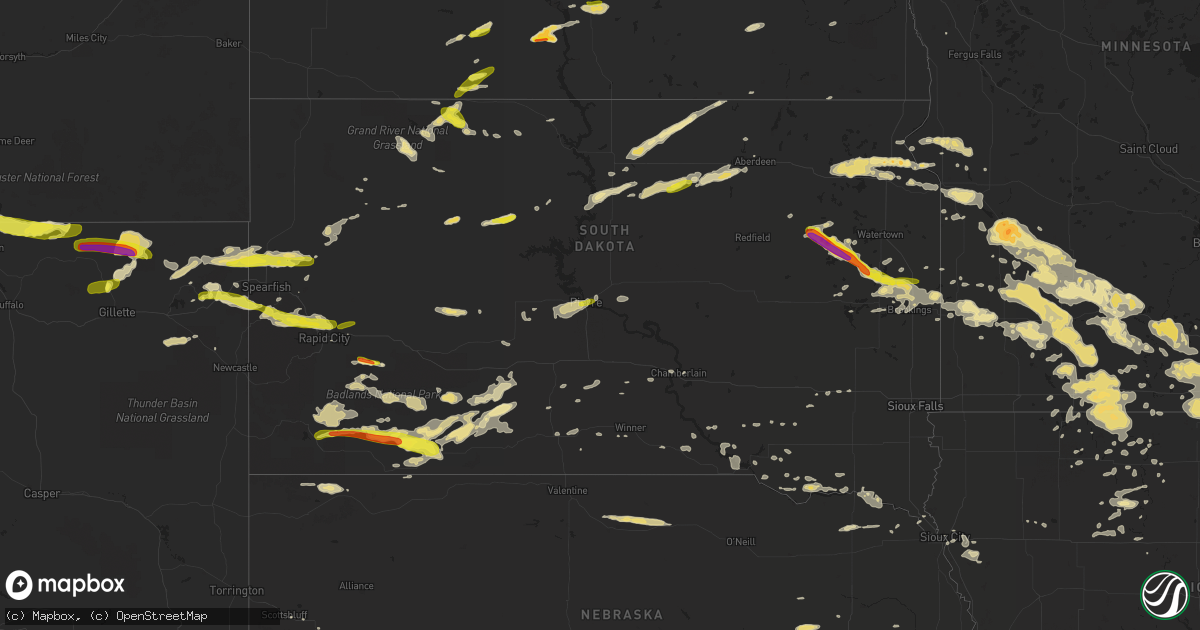
Hail Map in South Dakota on July 16, 2016
Get this storm
July 16 map
$229
one time, instant access
Download today. No call, no setup
Keep the $229
Bought the map and want the full workflow? Apply the entire $229 to a subscription within 7 days. None of it is wasted.
Every map, not just this one
This buys you this map. Subscription and you get every map we run, in the markets you choose from a few cities to whole states to nationwide. Plus real-time alerts the moment a storm fires.
Contact data
Name, contact info, occupancy, even credit band for addresses in the footprint. You go from where it hit to who to call.
Become the source they trust
Unlimited branding weather history reports on demand. You already have the documented answer ready for the property owner, and you are the one who showed up with it.
Property data and RoofTrace estimates
Pull up any address you have got, its value and the exact code rules for that jurisdiction, straight from One Click Code. Then RoofTrace estimates the squares, pitch, and roof value, priced the way you price.
Storm reports in South Dakota
South Dakota
| Date | Description |
|---|---|
| 07/16/20166:55 PM CDT | Tree fell on car. |
| 07/16/20166:52 PM CDT | A local report indicates 60 MPH wind near 4 N DOWNTOWN RAPID CITY |
| 07/16/20166:45 PM CDT | A local report indicates 69 MPH wind near NISLAND |
| 07/16/20166:39 PM CDT | Pea to quarter size hail covering the ground. |
| 07/16/20166:30 PM CDT | A local report indicates 1.00 inch wind near 7 NE SMITHWICK |
| 07/16/20166:30 PM CDT | A local report indicates 79 MPH wind near 13 NW DOWNTOWN BELLE FO |
| 07/16/20166:20 PM CDT | 1/2 hail covered the ground |
| 07/16/20166:18 PM CDT | Very strong winds as the storm began and then had hail from pea to quarter size. |
| 07/16/20166:18 PM CDT | Very strong winds as the storm began and then had hail from pea to quarter size. |
| 07/16/20166:00 PM CDT | A local report indicates 63 MPH wind near 8 W JEWEL CAVE |
| 07/16/20165:25 PM CDT | . |
| 07/16/20165:17 PM CDT | . |
| 07/16/20165:00 PM CDT | Winds of 50 to 60 mph. |
| 07/16/20165:00 PM CDT | . |
| 07/16/20164:55 PM CDT | A local report indicates 62 MPH wind near 9 W JEWEL CAVE |
| 07/16/20164:25 PM CDT | Road sign bent sideways and zero visibility. |
| 07/16/20164:20 PM CDT | Most of the hail was quarter size... But some was up to golfball size. Hail lasted 20 minutes. Not much rain. |
| 07/16/20164:20 PM CDT | Nickel to quarter size hail with heavy rain. |
| 07/16/20164:00 PM CDT | Some of the corn crop is twisted... Torn and bent over. |
| 07/16/20164:00 PM CDT | A local report indicates 1.00 inch wind near 6 NE ELLSWORTH AFB |
| 07/16/20163:40 PM CDT | Large machine shed received major damage to a wall and the roof. . |
| 07/16/20163:35 PM CDT | . |
| 07/16/20163:30 PM CDT | Several trees downed along with power lines mainly in southwest aberdeen. A hanger wall at the airport also damaged. . |
| 07/16/20162:25 PM CDT | No damage apparent at time of call. |
| 07/16/20161:47 PM CDT | . |
| 07/16/201611:50 AM CDT | A few stones like quarters. |
| 07/16/201612:30 AM CDT | Report and photos of large tree damage in portions of canton. Minor shingle damage. |
| 07/16/201612:20 AM CDT | Metal stop sign pole snapped...social media report...time estimated from radar. |
| 07/16/201612:14 AM CDT | 4 to 6 inch diameter tree branches down...time estimated from radar. |
| 07/16/201612:08 AM CDT | 3 inch diameter tree branch down...time estimated from radar. |
| 07/16/201612:04 AM CDT | Roof blown off building...time estimated from radar. |
| 07/15/201611:39 PM CDT | . |
| 07/15/201611:21 PM CDT | Sdsu site. |
| 07/15/201611:20 PM CDT | . |
| 07/15/201611:10 PM CDT | . |
| 07/15/201611:01 PM CDT | Measured with hand-held device. |
| 07/15/201610:55 PM CDT | Tree down in volga...time estimated from radar. |
| 07/15/201610:50 PM CDT | Social media report. |
| 07/15/201610:38 PM CDT | . |
| 07/15/201610:36 PM CDT | Few shingles blown off roof... Large tree limb down blocking road. Radar estimated time. |
| 07/15/201610:28 PM CDT | . |
| 07/15/201610:20 PM CDT | . |
| 07/15/201610:05 PM CDT | Winds in excess of 60mph began at approx 955pm cdt and continued through 1010pm cdt. Peak wind of 79mph at 1005pm cdt. |
| 07/15/201610:05 PM CDT | . |
| 07/15/201610:03 PM CDT | Mobridge asos. |
| 07/15/201610:00 PM CDT | . |
| 07/15/20169:58 PM CDT | . |
| 07/15/20169:54 PM CDT | . |
| 07/15/20169:51 PM CDT | . |
| 07/15/20169:51 PM CDT | . |
| 07/15/20169:50 PM CDT | Social media report. |
| 07/15/20169:45 PM CDT | . |
| 07/15/20169:38 PM CDT | . |
| 07/15/20169:38 PM CDT | Hail accompanied by 45-50 mph wind gusts. |
| 07/15/20169:28 PM CDT | . |
| 07/15/20169:26 PM CDT | . |
| 07/15/20169:08 PM CDT | . |
| 07/15/20169:08 PM CDT | . |
| 07/15/20168:45 PM CDT | . |
| 07/15/20168:40 PM CDT | A local report indicates 85 MPH wind near 1 WSW RED ELM |
| 07/15/20168:30 PM CDT | A local report indicates 62 MPH wind near 8 S PLAINVIEW |
| 07/15/20168:23 PM CDT | . |
| 07/15/20168:22 PM CDT | A local report indicates 64 MPH wind near 1 NNE FAITH |
| 07/15/20168:20 PM CDT | A local report indicates 79 MPH wind near 7 E WANBLEE |
| 07/15/20168:20 PM CDT | . |
| 07/15/20168:19 PM CDT | . |
| 07/15/20168:10 PM CDT | Wind gusts of 40 to 60 mph |
| 07/15/20167:50 PM CDT | Wall cloud still visible. |
| 07/15/20167:45 PM CDT | . |
| 07/15/20167:40 PM CDT | . |
| 07/15/20167:30 PM CDT | Hail covered the ground |
| 07/15/20167:27 PM CDT | Spotter 4 miles northwest of swett saw a tornado about 6 miles southeast of porcupine for about 2 minutes then it became rain wrapped. |
| 07/15/20167:20 PM CDT | Relayed via social media. Radar estimated time. |
| 07/15/20167:00 PM CDT | A local report indicates 72 MPH wind near NEWELL |
| 07/15/20167:00 PM CDT | Shed destroyed... Trailer tipped over... And large cottonwood trees were knocked down. |
| 07/15/20167:00 PM CDT | Horse trailer and pickup blown off highway. At least 1 injured. Farm/ranch just east of the highway sustained damage. Roof peeled off a barn... Travel trailer tipped ov |
All States Impacted by Hail Map on July 16, 2016
Cities Impacted by Hail Map on July 16, 2016
- Janesville, MN
- Sparrows Point, MD
- Dundalk, MD
- Baltimore, MD
- Essex, MD
- Middle River, MD
- Lake Mills, IA
- Joice, IA
- Kensett, IA
- Northwood, IA
- Braddock, ND
- Moffit, ND
- Baldwin, ND
- Kyle, SD
- Wanblee, SD
- Hermosa, SD
- Scenic, SD
- Albion, NE
- Austin, MN
- Hanlontown, IA
- Sargeant, MN
- Twin Lakes, MN
- Rose Creek, MN
- Thompson, IA
- Conger, MN
- New Richland, MN
- Adams, MN
- Hollandale, MN
- Brownsdale, MN
- Blooming Prairie, MN
- Emmons, MN
- Scarville, IA
- Freeborn, MN
- Lansing, MN
- Easton, MN
- Alden, MN
- Glenville, MN
- Clarks Grove, MN
- Grand Meadow, MN
- Wells, MN
- Minnesota Lake, MN
- Kiester, MN
- Mapleton, MN
- Albert Lea, MN
- Ellendale, MN
- Taopi, MN
- Waltham, MN
- Delavan, MN
- Geneva, MN
- Waldorf, MN
- Lyle, MN
- Bricelyn, MN
- Dexter, MN
- Hartland, MN
- Elkton, MN
- Hayward, MN
- Corsica, SD
- Newell, SD
- Wounded Knee, SD
- Manderson, SD
- Allen, SD
- Porcupine, SD
- Pine Ridge, SD
- Batesland, SD
- Martin, SD
- Wake Forest, NC
- Youngsville, NC
- Chadron, NE
- Owatonna, MN
- Sterling, ND
- Salem, SD
- Latta, SC
- Dillon, SC
- Center, ND
- Currie, MN
- Storden, MN
- Lamberton, MN
- Walnut Grove, MN
- Westbrook, MN
- Revere, MN
- Tracy, MN
- Dupree, SD
- Lantry, SD
- Eagle Butte, SD
- White, SD
- Gordon, NE
- Cannon Ball, ND
- Solen, ND
- Mandan, ND
- Stevenson, AL
- Wausa, NE
- Livingston, MT
- Pray, MT
- Bismarck, ND
- Wilton, ND
- Deadwood, SD
- Black Hawk, SD
- Nemo, SD
- Piedmont, SD
- Rapid City, SD
- Lead, SD
- Ipswich, SD
- Lebanon, NE
- Dawsonville, GA
- Cumming, GA
- Sundance, WY
- Arlington, SD
- Lake Norden, SD
- Upton, WY
- Lisbon, ND
- Enderlin, ND
- Zebulon, NC
- Selma, NC
- Clayton, NC
- Cleveland, ND
- Buchanan, ND
- Jamestown, ND
- Sioux City, IA
- Lewisburg, TN
- Vienna, SD
- Hazel, SD
- Clark, SD
- Keldron, SD
- Lemmon, SD
- Meadow, SD
- Watauga, SD
- Morristown, SD
- Belle Fourche, SD
- Franklin, NE
- Riverton, NE
- Summit, SD
- Grenville, SD
- Wilmot, SD
- Webster, SD
- Waubay, SD
- Peever, SD
- Carson, ND
- Lake Butler, FL
- Russell, MN
- Ruthton, MN
- Balaton, MN
- Clearmont, WY
- Agra, KS
- Kensington, KS
- Chester, SC
- Lafayette, MN
- Forman, ND
- Pineville, SC
- Cross, SC
- Silver City, IA
- Carrington, ND
- Sleepy Eye, MN
- Sandy Hook, KY
- Blaine, KY
- Martha, KY
- Philip, SD
- Milesville, SD
- Weston, WY
- Jefferson, SC
- Tyndall, SD
- Springfield, SD
- Long Valley, SD
- Norris, SD
- Tuttle, ND
- Wing, ND
- Grover, CO
- Dumont, MN
- Graceville, MN
- Chokio, MN
- Fort Peck, MT
- Whigham, GA
- Anderson, AL
- Athens, AL
- Rogersville, AL
- Ainsworth, NE
- Chicora, PA
- Cowansville, PA
- East Brady, PA
- Worthington, PA
- Flasher, ND
- Parkman, WY
- Lakefield, MN
- Spirit Lake, IA
- Regan, ND
- Batavia, IA
- Packwood, IA
- Parkston, SD
- Huntsville, AL
- Brownsboro, AL
- Savage, MT
- Clinton, MN
- Norton, KS
- Hazen, ND
- Dawson, ND
- Tappen, ND
- Sisseton, SD
- Ivanhoe, MN
- Renville, MN
- Sacred Heart, MN
- Bowdle, SD
- Eureka, SD
- Saint Helena, NE
- Ranchester, WY
- Wyola, MT
- Decker, MT
- Sheridan, WY
- Fairfax, MN
- Zap, ND
- Golden Valley, ND
- Selfridge, ND
- Ryegate, MT
- Lavina, MT
- Midland, SD
- Norcatur, KS
- Wilsonville, NE
- Armstrong, IA
- Naponee, NE
- Otter, MT
- Ball Ground, GA
- Labelle, FL
- Raymond, SD
- Brookings, SD
- Estelline, SD
- Hayti, SD
- Willow Lake, SD
- Bryant, SD
- Aurora, SD
- Bruce, SD
- Franklin, MN
- Gibbon, MN
- Clements, MN
- Redwood Falls, MN
- Morgan, MN
- Morton, MN
- Belview, MN
- Echo, MN
- Lucan, MN
- De Smet, SD
- Erwin, SD
- New Ulm, MN
- Lake Crystal, MN
- Nicollet, MN
- Courtland, MN
- Madelia, MN
- Saint James, MN
- Hanska, MN
- Big Timber, MT
- Naples, FL
- Toney, AL
- Maynard, MN
- Clara City, MN
- Granite Falls, MN
- Seaforth, MN
- Watson, MN
- Wood Lake, MN
- Olivia, MN
- Clarkfield, MN
- Wabasso, MN
- Dawson, MN
- Danube, MN
- Boyd, MN
- Montevideo, MN
- Fort Pierre, SD
- Pierre, SD
- Winner, SD
- Lottie, LA
- Fairfield, IA
- Lockridge, IA
- Wesley, IA
- Hixson, TN
- New Leipzig, ND
- Beulah, WY
- Alva, WY
- Aladdin, WY
- Minatare, NE
- Logan, KS
- Phillipsburg, KS
- Madison Lake, MN
- Eagle Lake, MN
- Dolliver, IA
- Fairmont, MN
- Estherville, IA
- Dunnell, MN
- Ceylon, MN
- Garden City, MN
- Vernon Center, MN
- Bancroft, IA
- Burt, IA
- Gainesville, FL
- Alachua, FL
- Devils Tower, WY
- Wall, SD
- Birney, MT
- Richey, MT
- Lambert, MT
- Almena, KS
- Indianola, NE
- Danbury, NE
- Hendley, NE
- Beaver City, NE
- Oberlin, KS
- Steele, ND
- Washburn, ND
- Menoken, ND
- Underwood, ND
- New Salem, ND
- Stanton, ND
- Driscoll, ND
- Pettibone, ND
- Robinson, ND
- Fort Dodge, IA
- Dixon, NE
- Salem, IA
- Oral, SD
- Buffalo Gap, SD
- Windom, MN
- Ringsted, IA
- Fenton, IA
- Alpha, MN
- Trimont, MN
- Jackson, MN
- Bingham Lake, MN
- Swea City, IA
- Heron Lake, MN
- Granada, MN
- Welcome, MN
- Sherburn, MN
- Truman, MN
- Ormsby, MN
- Odin, MN
- Oacoma, SD
- Whittemore, IA
- Chattanooga, TN
- Harrison, TN
- Ooltewah, TN
- Detroit Lakes, MN
- McLaughlin, SD
- Hopewell, PA
- Nisland, SD
- Hedrick, IA
- Caputa, SD
- Manchester Center, VT
- Manchester, VT
- Hulett, WY
- Moorcroft, WY
- Bloomington, NE
- Dayton, WY
- Gilmore City, IA
- Palmer, IA
- Holloway, MN
- Appleton, MN
- Hollywood, AL
- Cresco, IA
- Ellenboro, NC
- Whitney, NE
- Concord, NC
- Mission, SD
- Minneota, MN
- Cherokee, IA
- Aurelia, IA
- Garvin, MN
- Shelby, NC
- Moville, IA
- Medina, ND
- Brandt, SD
- Hartington, NE
- Register, GA
- Portal, GA
- Metter, GA
- Pulaski, GA
- Statesboro, GA
- Graettinger, IA
- Cylinder, IA
- Prairie City, SD
- Punta Gorda, FL
- Springfield, MN
- Wanda, MN
- Sanborn, MN
- Lawndale, NC
- Rockford, AL
- Carson, IA
- Macedonia, IA
- Gillette, WY
- Whitewood, SD
- Spearfish, SD
- Sturgis, SD
- Roscoe, SD
- Arcadia, FL
- Kennebec, SD
- Scottsbluff, NE
- Elgin, NE
- Oakdale, NE
- Bradgate, IA
- Onaka, SD
- Hoven, SD
- Tolstoy, SD
- Winfield, IA
- Mount Union, IA
- Madison, MN
- Vandemere, NC
- Bayboro, NC
- Winchester, TN
- Reliance, TN
- Newman Grove, NE
- Laurel, MD
- Beltsville, MD
- Long Island, KS
- Waseca, MN
- Marietta, MN
- Fordyce, NE
- Melville, MT
- Ridgeway, IA
- Decorah, IA
- Grantsboro, NC
- New Bern, NC
- Chester, IA
- Elgin, ND
- Pemberton, MN
- Corona, SD
- Milbank, SD
- Big Stone City, SD
- Twin Brooks, SD
- Republican City, NE
- Avon, SD
- Wagner, SD
- Agenda, KS
- Lake Benton, MN
- Arco, MN
- Tyler, MN
- Osage, WY
- Fenelton, PA
- Hobucken, NC
- Columbia, TN
- Santa Fe, TN
- Comfrey, MN
- Jeffers, MN
- Butterfield, MN
- Darfur, MN
- Vesta, MN
- Mountain Lake, MN
- Marshall, MN
- Milroy, MN
- Jasper, GA
- Tuscumbia, AL
- Boston, GA
- Folkston, GA
- Hilliard, FL
- Beardsley, MN
- Pikeville, TN
- Evensville, TN
- Glade, KS
- Faith, SD
- Tabor, SD
- Beulah, ND
- Milford, IA
- Okoboji, IA
- Henderson, IA
- Anthon, IA
- Climbing Hill, IA
- Bronson, IA
- Hornick, IA
- Titonka, IA
- Ellendale, ND
- Hickory, NC
- Allendale, SC
- Fairfax, SC
- Mallard, IA
- Emmetsburg, IA
- West Bend, IA
- Correll, MN
- Dickey, ND
- Batesburg, SC
- Grace City, ND
- Reliance, SD
- Riceville, IA
- Alva, FL
- Salix, IA
- Griswold, IA
- Volga, SD
- Audubon, MN
- Gayville, SD
- Wynot, NE
- Vermillion, SD
- Odessa, MN
- Bellingham, MN
- Elkton, SD
- Fairburn, SD
- Blunt, SD
- Cypress Inn, TN
- Iron City, TN
- Leola, SD
- Alexandria, SD
- Hosmer, SD
- Java, SD
- Long Lake, SD
- Ethan, SD
- Dickens, IA
- Chester, VA
- Charles City, VA
- Hendricks, MN
- Henry, SD
- Garden City, SD
- Raleigh, NC
- Brooker, FL
- Gettysburg, SD
- Ortley, SD
- Cope, SC
- Smith Center, KS
- Humboldt, IA
- Livermore, IA
- Elk Point, SD
- Mud Butte, SD
- Westport, SD
- Lu Verne, IA
- Rowesville, SC
- Branchville, SC
- Wood, SD
- Silver Springs, FL
- McIntosh, SD
- Lawrenceburg, TN
- Leoma, TN
- Ridgeway, SC
- Franklinton, NC
- Schuyler, NE
- Marion, ND
- Edgeley, ND
- Pomeroy, IA
- White River, SD
- Slayton, MN
- Cottonwood, MN
- Good Thunder, MN
- Bird Island, MN
- Hanley Falls, MN
- Mankato, MN
- Kasota, MN
- Saint Clair, MN
- Kannapolis, NC
- Selby, SD
- Shawmut, MT
- Dallas, SD
- Lawton, IA
- Claremont, MN
- Mcdonough, GA
- Harvest, AL
- Turton, SD
- Algona, IA
- Yankton, SD
- Groveland, FL
- Bowman, SC
- Johnstown, NE
- Bassett, NE
- Long Pine, NE
- Ortonville, MN
- Hazelton, ND
- Amboy, MN
- Atalissa, IA
- West Liberty, IA
- Lake Preston, SD
- Belvidere, TN
- Lynchburg, TN
- Tullahoma, TN
- Mooresboro, NC
- Lake Park, MN
- Pelican Rapids, MN
- Bowie, MD
- Maysville, NC
- Blue Earth, MN
- Geddes, SD
- West Liberty, KY
- Elmore, MN
- Conover, NC
- Newton, NC
- Columbus, NE
- Leigh, NE
- Cherryville, NC
- Prairie View, KS
- Chamberlain, SD
- Cleveland, TN
- Arvada, WY
- Hemingway, SC
- Fulda, MN
- Lewis, IA
- Rolfe, IA
- Rutland, IA
- Platte, SD
- Benton, TN
- Rocky Mount, NC
- Elm City, NC
- Woodstock, MN
- Bridgewater, SD
- Vance, SC
- Aberdeen, SD
- Leesville, SC
- Lake Andes, SD
- Fairfax, SD
- Burke, SD
- Mount Pleasant, IA
- La Fayette, GA
- Wilson, NC
- Pinetops, NC
- Tarboro, NC
- Winnebago, MN
- Pacolet, SC
- Spartanburg, SC
- Glendale, SC
- Gaffney, SC
- Henrico, VA
- Ruthven, IA
- Dayton, TN
- Hot Springs, SD
- Pocahontas, IA
- Fackler, AL
- Corbin, KY
- Williamsburg, KY
- Ledyard, IA
- Frazee, MN
- Apex, NC
- Humphrey, NE
- Lame Deer, MT
- Smithwick, SD
- Poplar, MT
- Crawfordsville, IA
- Lime Springs, IA
- Lehigh Acres, FL
- Bode, IA
- Ottosen, IA
- Coleridge, NE
- Newcastle, NE
- Dodge, NE
- Howells, NE
- Meridianville, AL
- Morning Sun, IA
- Ocklawaha, FL
- Castlewood, SD
- Moorland, IA
- Blenheim, SC
- Alma, NE
- Manson, IA
- Clare, IA
- Lone Rock, IA
- Morriston, FL
- Williston, FL
- Winnsboro, SC
- Waldron, AR
- Elliott, IA
- Treynor, IA
- Red Oak, IA
- Emerson, IA
- Alta, IA
- Isonville, KY
- Jolley, IA
- Blythewood, SC
- Ghent, MN
- Edgemont, SD
- Buffalo Center, IA
- Rogers, NE
- Linwood, NE
- Olivebridge, NY
- Corwith, IA
- Louisa, VA
- Old Fort, NC
- Conway, SC
- Oskaloosa, IA
- Saco, MT
- Venus, FL
- Georgetown, SC
- Lesterville, SD
- Utica, SD
- Rocky Ford, GA
- Millen, GA
- Garfield, GA
- Delmont, SD
- Ideal, SD
- Vale, SD
- Carlisle, SC
- Madison, NE
- Equality, AL
- McDonald, TN
- Clermont, FL
- Rock Island, TN
- Broadus, MT
- Killen, AL
- Le Roy, MN
- Columbia, NC
- Garner, NC
- Walsh, CO
- Williamsport, TN
- Primm Springs, TN
- Box Elder, SD
- Bayard, NE
- Ocoee, TN
- Crane, MT
- Atlanta, GA
- Warner, OK
- Muskogee, OK
- Rothsay, MN
- Terril, IA
- Presho, SD
- Twin City, GA
- Morganton, NC
- Emery, SD
- Glenn Dale, MD
- Fort George G Meade, MD
- Armour, SD
- Hopewell, VA
- Marion, NC
- Bison, SD
- Sunbright, TN
- Dante, SD
- Johnsonville, SC
- Cassatt, SC
- Stamford, TX
- Throckmorton, TX
- Weinert, TX
- Haskell, TX
- Aspermont, TX
- Rule, TX
- Old Glory, TX
- Diana, TX
- Ore City, TX
- Gilmer, TX
- Hallsville, TX
- Longview, TX
- Woodworth, ND
- Raleigh, ND
- Recluse, WY
- Ellsworth Afb, SD
- Toronto, SD


