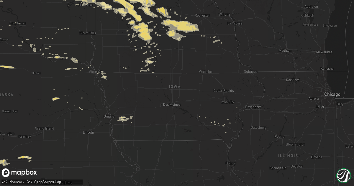
Hail Map in Iowa on July 16, 2016
Get this storm
July 16 map
$229
one time, instant access
Download today. No call, no setup
Keep the $229
Bought the map and want the full workflow? Apply the entire $229 to a subscription within 7 days. None of it is wasted.
Every map, not just this one
This buys you this map. Subscription and you get every map we run, in the markets you choose from a few cities to whole states to nationwide. Plus real-time alerts the moment a storm fires.
Contact data
Name, contact info, occupancy, even credit band for addresses in the footprint. You go from where it hit to who to call.
Become the source they trust
Unlimited branding weather history reports on demand. You already have the documented answer ready for the property owner, and you are the one who showed up with it.
Property data and RoofTrace estimates
Pull up any address you have got, its value and the exact code rules for that jurisdiction, straight from One Click Code. Then RoofTrace estimates the squares, pitch, and roof value, priced the way you price.
Storm reports in Iowa
Iowa
| Date | Description |
|---|---|
| 07/16/20166:35 AM CDT | Tree uprooted and crown snapped along with a 6 inch diameter branches down. Time estimated using radar. |
| 07/16/20166:30 AM CDT | 4 to 6 inch diameter branches broken off an blown 100 to 200 yards. Tree was along u.s. 61 north of le claire road east of eldridge. Time estimated from radar. |
| 07/16/20166:25 AM CDT | Tree bracnches down along the 2200 block of north washington street in davenport. Branches snapped off trees and partially in the street. No damage to structures. Time |
| 07/16/20166:25 AM CDT | 3 inch limb down in a driveway |
| 07/16/20166:25 AM CDT | Near farm along old 61 between parkview and elderige....tops of trees twisted off and corn laying down in neighboring field with some of the corn ripped out. |
| 07/16/20166:25 AM CDT | Brief ef-0 tornado did damage to trees and corn crops. |
| 07/16/20166:25 AM CDT | Numerous trees down on se side of town. Some trees fell on roofs of houses. |
| 07/16/20166:23 AM CDT | Law enforcement reported significant damage to a building with nearby trees twisted and some farm equipment knocked over. |
| 07/16/20166:23 AM CDT | Law enforcement reported several trees down in dewitt. |
| 07/16/20166:22 AM CDT | Mulberry tree blown over... Numerous other limbs down |
| 07/16/20166:22 AM CDT | Tree branches down...some 2 to 6 inches in diameter. Time estimated from radar. |
| 07/16/20166:22 AM CDT | A local report indicates 60 MPH wind near PARK VIEW |
| 07/16/20166:03 AM CDT | Ef-1 tornado crossed the southern parts of the town of andrew. A building at the ag coop was destroyed and numerous trees were snapped. |
| 07/16/20166:02 AM CDT | A couple of trees were uprooted in town. Time of the event estimated using radar. |
| 07/16/20165:46 AM CDT | Multiple homes damage in walford with one collapsed. |
| 07/16/20165:15 AM CDT | Kcrg equipment measurement at xavier high school on the west side of cedar rapids. Time of the event is estimated since exact time is unknown. |
| 07/16/20165:10 AM CDT | Report was delayed....spotter observed power flahes around 510 and this morning there were power lines down in the area with the power out. |
| 07/16/20164:55 AM CDT | Roof blown off a large apartment building and a house damaged. Time estimated from radar. |
| 07/16/20164:55 AM CDT | Estimated winds of 70 to 75 mph based on the movement of the trees. No damage was visible at the time of the report. |
| 07/16/20164:54 AM CDT | Grain bin destroyed with another with the side pushed in by the wind. |
| 07/16/20164:49 AM CDT | Grain bin destroyed and blown into another structure. The grain bin was empty |
| 07/16/20164:35 AM CDT | Numerous 2 to 6 inch diameter tree limbs down in raymar. Relayed by kwwl. Time estimated from radar. |
| 07/16/20164:35 AM CDT | A shed and a morton building partially destroyed. Numerous trees at least 12 to 18 inches in diameter snapped near the base. |
| 07/16/20164:13 AM CDT | Trees and large branches downed in town. Time estimated via radar. Report received from social media. |
| 07/16/20164:04 AM CDT | Steamboat rock rwis measured wind of 55mph sustained and 88mph gust. |
| 07/16/20163:59 AM CDT | Several large trees and power lines down in steamboat rock. At least 2 power poles snapped in half just west of steamboat rock on d35. |
| 07/16/20163:56 AM CDT | Several power lines and large trees down throughout the town of ackley as well as other portions of hardin county. |
| 07/16/20163:41 AM CDT | Trees and large branches down at jewell golf and country club. Report via social media. . |
| 07/16/20163:37 AM CDT | Trained spotter reported several 24 to 36 inch trees in diameter completely gone. 40 foot tall tree downed. Additional tree downed onto nearby house. Time and location |
| 07/16/20163:08 AM CDT | Trees down around town. |
| 07/16/20163:07 AM CDT | Several trees down around town. Time estimated. |
| 07/16/20163:07 AM CDT | Several large trees down... Either split in half or completely toppled over... Throughout the town of eagle grove. One large tree fell on a house along west broadway. S |
| 07/16/20163:07 AM CDT | Peak winds estimated 60 to 70 mph. |
| 07/16/20163:07 AM CDT | Law enforcement reported downed trees and debris blocking roadway ia 17. Time estimated from radar. |
| 07/16/20163:03 AM CDT | Multiple power lines and large trees down from goldfield to eagle grove. |
| 07/16/20163:01 AM CDT | 4 machine sheds damage/destroyed. Time estimated from radar. . |
| 07/16/20162:59 AM CDT | Large tree fell on top of a vehicle. |
| 07/16/20162:59 AM CDT | One-third of a roof off an implement and farm supply store. Camper on its side. Multiple power lines and large trees down throughout the town blocking many streets. Gra |
| 07/16/20162:56 AM CDT | Machine shed destroyed. |
| 07/16/20162:49 AM CDT | Law enforcement reported a large tree downed onto hwy 169. |
| 07/16/20162:37 AM CDT | Law enforcement reported a tree down onto a house. Time and location estimated. |
| 07/16/20162:32 AM CDT | Law enforcement reported a tree at least 1 foot in diameter downed onto roadway. Time and location estimated. |
| 07/16/20162:08 AM CDT | Tree uprooted. Time estimated. |
| 07/16/20162:02 AM CDT | 3 empty grain silos moved off their footings and numerous trees uprooted . |
| 07/16/20161:08 AM CDT | Reports of tree and crop damage. Also damage to machine shed structure. Report from social media. . |
All States Impacted by Hail Map on July 16, 2016
Cities Impacted by Hail Map on July 16, 2016
- Janesville, MN
- Sparrows Point, MD
- Dundalk, MD
- Baltimore, MD
- Essex, MD
- Middle River, MD
- Lake Mills, IA
- Joice, IA
- Kensett, IA
- Northwood, IA
- Braddock, ND
- Moffit, ND
- Baldwin, ND
- Kyle, SD
- Wanblee, SD
- Hermosa, SD
- Scenic, SD
- Albion, NE
- Austin, MN
- Hanlontown, IA
- Sargeant, MN
- Twin Lakes, MN
- Rose Creek, MN
- Thompson, IA
- Conger, MN
- New Richland, MN
- Adams, MN
- Hollandale, MN
- Brownsdale, MN
- Blooming Prairie, MN
- Emmons, MN
- Scarville, IA
- Freeborn, MN
- Lansing, MN
- Easton, MN
- Alden, MN
- Glenville, MN
- Clarks Grove, MN
- Grand Meadow, MN
- Wells, MN
- Minnesota Lake, MN
- Kiester, MN
- Mapleton, MN
- Albert Lea, MN
- Ellendale, MN
- Taopi, MN
- Waltham, MN
- Delavan, MN
- Geneva, MN
- Waldorf, MN
- Lyle, MN
- Bricelyn, MN
- Dexter, MN
- Hartland, MN
- Elkton, MN
- Hayward, MN
- Corsica, SD
- Newell, SD
- Wounded Knee, SD
- Manderson, SD
- Allen, SD
- Porcupine, SD
- Pine Ridge, SD
- Batesland, SD
- Martin, SD
- Wake Forest, NC
- Youngsville, NC
- Chadron, NE
- Owatonna, MN
- Sterling, ND
- Salem, SD
- Latta, SC
- Dillon, SC
- Center, ND
- Currie, MN
- Storden, MN
- Lamberton, MN
- Walnut Grove, MN
- Westbrook, MN
- Revere, MN
- Tracy, MN
- Dupree, SD
- Lantry, SD
- Eagle Butte, SD
- White, SD
- Gordon, NE
- Cannon Ball, ND
- Solen, ND
- Mandan, ND
- Stevenson, AL
- Wausa, NE
- Livingston, MT
- Pray, MT
- Bismarck, ND
- Wilton, ND
- Deadwood, SD
- Black Hawk, SD
- Nemo, SD
- Piedmont, SD
- Rapid City, SD
- Lead, SD
- Ipswich, SD
- Lebanon, NE
- Dawsonville, GA
- Cumming, GA
- Sundance, WY
- Arlington, SD
- Lake Norden, SD
- Upton, WY
- Lisbon, ND
- Enderlin, ND
- Zebulon, NC
- Selma, NC
- Clayton, NC
- Cleveland, ND
- Buchanan, ND
- Jamestown, ND
- Sioux City, IA
- Lewisburg, TN
- Vienna, SD
- Hazel, SD
- Clark, SD
- Keldron, SD
- Lemmon, SD
- Meadow, SD
- Watauga, SD
- Morristown, SD
- Belle Fourche, SD
- Franklin, NE
- Riverton, NE
- Summit, SD
- Grenville, SD
- Wilmot, SD
- Webster, SD
- Waubay, SD
- Peever, SD
- Carson, ND
- Lake Butler, FL
- Russell, MN
- Ruthton, MN
- Balaton, MN
- Clearmont, WY
- Agra, KS
- Kensington, KS
- Chester, SC
- Lafayette, MN
- Forman, ND
- Pineville, SC
- Cross, SC
- Silver City, IA
- Carrington, ND
- Sleepy Eye, MN
- Sandy Hook, KY
- Blaine, KY
- Martha, KY
- Philip, SD
- Milesville, SD
- Weston, WY
- Jefferson, SC
- Tyndall, SD
- Springfield, SD
- Long Valley, SD
- Norris, SD
- Tuttle, ND
- Wing, ND
- Grover, CO
- Dumont, MN
- Graceville, MN
- Chokio, MN
- Fort Peck, MT
- Whigham, GA
- Anderson, AL
- Athens, AL
- Rogersville, AL
- Ainsworth, NE
- Chicora, PA
- Cowansville, PA
- East Brady, PA
- Worthington, PA
- Flasher, ND
- Parkman, WY
- Lakefield, MN
- Spirit Lake, IA
- Regan, ND
- Batavia, IA
- Packwood, IA
- Parkston, SD
- Huntsville, AL
- Brownsboro, AL
- Savage, MT
- Clinton, MN
- Norton, KS
- Hazen, ND
- Dawson, ND
- Tappen, ND
- Sisseton, SD
- Ivanhoe, MN
- Renville, MN
- Sacred Heart, MN
- Bowdle, SD
- Eureka, SD
- Saint Helena, NE
- Ranchester, WY
- Wyola, MT
- Decker, MT
- Sheridan, WY
- Fairfax, MN
- Zap, ND
- Golden Valley, ND
- Selfridge, ND
- Ryegate, MT
- Lavina, MT
- Midland, SD
- Norcatur, KS
- Wilsonville, NE
- Armstrong, IA
- Naponee, NE
- Otter, MT
- Ball Ground, GA
- Labelle, FL
- Raymond, SD
- Brookings, SD
- Estelline, SD
- Hayti, SD
- Willow Lake, SD
- Bryant, SD
- Aurora, SD
- Bruce, SD
- Franklin, MN
- Gibbon, MN
- Clements, MN
- Redwood Falls, MN
- Morgan, MN
- Morton, MN
- Belview, MN
- Echo, MN
- Lucan, MN
- De Smet, SD
- Erwin, SD
- New Ulm, MN
- Lake Crystal, MN
- Nicollet, MN
- Courtland, MN
- Madelia, MN
- Saint James, MN
- Hanska, MN
- Big Timber, MT
- Naples, FL
- Toney, AL
- Maynard, MN
- Clara City, MN
- Granite Falls, MN
- Seaforth, MN
- Watson, MN
- Wood Lake, MN
- Olivia, MN
- Clarkfield, MN
- Wabasso, MN
- Dawson, MN
- Danube, MN
- Boyd, MN
- Montevideo, MN
- Fort Pierre, SD
- Pierre, SD
- Winner, SD
- Lottie, LA
- Fairfield, IA
- Lockridge, IA
- Wesley, IA
- Hixson, TN
- New Leipzig, ND
- Beulah, WY
- Alva, WY
- Aladdin, WY
- Minatare, NE
- Logan, KS
- Phillipsburg, KS
- Madison Lake, MN
- Eagle Lake, MN
- Dolliver, IA
- Fairmont, MN
- Estherville, IA
- Dunnell, MN
- Ceylon, MN
- Garden City, MN
- Vernon Center, MN
- Bancroft, IA
- Burt, IA
- Gainesville, FL
- Alachua, FL
- Devils Tower, WY
- Wall, SD
- Birney, MT
- Richey, MT
- Lambert, MT
- Almena, KS
- Indianola, NE
- Danbury, NE
- Hendley, NE
- Beaver City, NE
- Oberlin, KS
- Steele, ND
- Washburn, ND
- Menoken, ND
- Underwood, ND
- New Salem, ND
- Stanton, ND
- Driscoll, ND
- Pettibone, ND
- Robinson, ND
- Fort Dodge, IA
- Dixon, NE
- Salem, IA
- Oral, SD
- Buffalo Gap, SD
- Windom, MN
- Ringsted, IA
- Fenton, IA
- Alpha, MN
- Trimont, MN
- Jackson, MN
- Bingham Lake, MN
- Swea City, IA
- Heron Lake, MN
- Granada, MN
- Welcome, MN
- Sherburn, MN
- Truman, MN
- Ormsby, MN
- Odin, MN
- Oacoma, SD
- Whittemore, IA
- Chattanooga, TN
- Harrison, TN
- Ooltewah, TN
- Detroit Lakes, MN
- McLaughlin, SD
- Hopewell, PA
- Nisland, SD
- Hedrick, IA
- Caputa, SD
- Manchester Center, VT
- Manchester, VT
- Hulett, WY
- Moorcroft, WY
- Bloomington, NE
- Dayton, WY
- Gilmore City, IA
- Palmer, IA
- Holloway, MN
- Appleton, MN
- Hollywood, AL
- Cresco, IA
- Ellenboro, NC
- Whitney, NE
- Concord, NC
- Mission, SD
- Minneota, MN
- Cherokee, IA
- Aurelia, IA
- Garvin, MN
- Shelby, NC
- Moville, IA
- Medina, ND
- Brandt, SD
- Hartington, NE
- Register, GA
- Portal, GA
- Metter, GA
- Pulaski, GA
- Statesboro, GA
- Graettinger, IA
- Cylinder, IA
- Prairie City, SD
- Punta Gorda, FL
- Springfield, MN
- Wanda, MN
- Sanborn, MN
- Lawndale, NC
- Rockford, AL
- Carson, IA
- Macedonia, IA
- Gillette, WY
- Whitewood, SD
- Spearfish, SD
- Sturgis, SD
- Roscoe, SD
- Arcadia, FL
- Kennebec, SD
- Scottsbluff, NE
- Elgin, NE
- Oakdale, NE
- Bradgate, IA
- Onaka, SD
- Hoven, SD
- Tolstoy, SD
- Winfield, IA
- Mount Union, IA
- Madison, MN
- Vandemere, NC
- Bayboro, NC
- Winchester, TN
- Reliance, TN
- Newman Grove, NE
- Laurel, MD
- Beltsville, MD
- Long Island, KS
- Waseca, MN
- Marietta, MN
- Fordyce, NE
- Melville, MT
- Ridgeway, IA
- Decorah, IA
- Grantsboro, NC
- New Bern, NC
- Chester, IA
- Elgin, ND
- Pemberton, MN
- Corona, SD
- Milbank, SD
- Big Stone City, SD
- Twin Brooks, SD
- Republican City, NE
- Avon, SD
- Wagner, SD
- Agenda, KS
- Lake Benton, MN
- Arco, MN
- Tyler, MN
- Osage, WY
- Fenelton, PA
- Hobucken, NC
- Columbia, TN
- Santa Fe, TN
- Comfrey, MN
- Jeffers, MN
- Butterfield, MN
- Darfur, MN
- Vesta, MN
- Mountain Lake, MN
- Marshall, MN
- Milroy, MN
- Jasper, GA
- Tuscumbia, AL
- Boston, GA
- Folkston, GA
- Hilliard, FL
- Beardsley, MN
- Pikeville, TN
- Evensville, TN
- Glade, KS
- Faith, SD
- Tabor, SD
- Beulah, ND
- Milford, IA
- Okoboji, IA
- Henderson, IA
- Anthon, IA
- Climbing Hill, IA
- Bronson, IA
- Hornick, IA
- Titonka, IA
- Ellendale, ND
- Hickory, NC
- Allendale, SC
- Fairfax, SC
- Mallard, IA
- Emmetsburg, IA
- West Bend, IA
- Correll, MN
- Dickey, ND
- Batesburg, SC
- Grace City, ND
- Reliance, SD
- Riceville, IA
- Alva, FL
- Salix, IA
- Griswold, IA
- Volga, SD
- Audubon, MN
- Gayville, SD
- Wynot, NE
- Vermillion, SD
- Odessa, MN
- Bellingham, MN
- Elkton, SD
- Fairburn, SD
- Blunt, SD
- Cypress Inn, TN
- Iron City, TN
- Leola, SD
- Alexandria, SD
- Hosmer, SD
- Java, SD
- Long Lake, SD
- Ethan, SD
- Dickens, IA
- Chester, VA
- Charles City, VA
- Hendricks, MN
- Henry, SD
- Garden City, SD
- Raleigh, NC
- Brooker, FL
- Gettysburg, SD
- Ortley, SD
- Cope, SC
- Smith Center, KS
- Humboldt, IA
- Livermore, IA
- Elk Point, SD
- Mud Butte, SD
- Westport, SD
- Lu Verne, IA
- Rowesville, SC
- Branchville, SC
- Wood, SD
- Silver Springs, FL
- McIntosh, SD
- Lawrenceburg, TN
- Leoma, TN
- Ridgeway, SC
- Franklinton, NC
- Schuyler, NE
- Marion, ND
- Edgeley, ND
- Pomeroy, IA
- White River, SD
- Slayton, MN
- Cottonwood, MN
- Good Thunder, MN
- Bird Island, MN
- Hanley Falls, MN
- Mankato, MN
- Kasota, MN
- Saint Clair, MN
- Kannapolis, NC
- Selby, SD
- Shawmut, MT
- Dallas, SD
- Lawton, IA
- Claremont, MN
- Mcdonough, GA
- Harvest, AL
- Turton, SD
- Algona, IA
- Yankton, SD
- Groveland, FL
- Bowman, SC
- Johnstown, NE
- Bassett, NE
- Long Pine, NE
- Ortonville, MN
- Hazelton, ND
- Amboy, MN
- Atalissa, IA
- West Liberty, IA
- Lake Preston, SD
- Belvidere, TN
- Lynchburg, TN
- Tullahoma, TN
- Mooresboro, NC
- Lake Park, MN
- Pelican Rapids, MN
- Bowie, MD
- Maysville, NC
- Blue Earth, MN
- Geddes, SD
- West Liberty, KY
- Elmore, MN
- Conover, NC
- Newton, NC
- Columbus, NE
- Leigh, NE
- Cherryville, NC
- Prairie View, KS
- Chamberlain, SD
- Cleveland, TN
- Arvada, WY
- Hemingway, SC
- Fulda, MN
- Lewis, IA
- Rolfe, IA
- Rutland, IA
- Platte, SD
- Benton, TN
- Rocky Mount, NC
- Elm City, NC
- Woodstock, MN
- Bridgewater, SD
- Vance, SC
- Aberdeen, SD
- Leesville, SC
- Lake Andes, SD
- Fairfax, SD
- Burke, SD
- Mount Pleasant, IA
- La Fayette, GA
- Wilson, NC
- Pinetops, NC
- Tarboro, NC
- Winnebago, MN
- Pacolet, SC
- Spartanburg, SC
- Glendale, SC
- Gaffney, SC
- Henrico, VA
- Ruthven, IA
- Dayton, TN
- Hot Springs, SD
- Pocahontas, IA
- Fackler, AL
- Corbin, KY
- Williamsburg, KY
- Ledyard, IA
- Frazee, MN
- Apex, NC
- Humphrey, NE
- Lame Deer, MT
- Smithwick, SD
- Poplar, MT
- Crawfordsville, IA
- Lime Springs, IA
- Lehigh Acres, FL
- Bode, IA
- Ottosen, IA
- Coleridge, NE
- Newcastle, NE
- Dodge, NE
- Howells, NE
- Meridianville, AL
- Morning Sun, IA
- Ocklawaha, FL
- Castlewood, SD
- Moorland, IA
- Blenheim, SC
- Alma, NE
- Manson, IA
- Clare, IA
- Lone Rock, IA
- Morriston, FL
- Williston, FL
- Winnsboro, SC
- Waldron, AR
- Elliott, IA
- Treynor, IA
- Red Oak, IA
- Emerson, IA
- Alta, IA
- Isonville, KY
- Jolley, IA
- Blythewood, SC
- Ghent, MN
- Edgemont, SD
- Buffalo Center, IA
- Rogers, NE
- Linwood, NE
- Olivebridge, NY
- Corwith, IA
- Louisa, VA
- Old Fort, NC
- Conway, SC
- Oskaloosa, IA
- Saco, MT
- Venus, FL
- Georgetown, SC
- Lesterville, SD
- Utica, SD
- Rocky Ford, GA
- Millen, GA
- Garfield, GA
- Delmont, SD
- Ideal, SD
- Vale, SD
- Carlisle, SC
- Madison, NE
- Equality, AL
- McDonald, TN
- Clermont, FL
- Rock Island, TN
- Broadus, MT
- Killen, AL
- Le Roy, MN
- Columbia, NC
- Garner, NC
- Walsh, CO
- Williamsport, TN
- Primm Springs, TN
- Box Elder, SD
- Bayard, NE
- Ocoee, TN
- Crane, MT
- Atlanta, GA
- Warner, OK
- Muskogee, OK
- Rothsay, MN
- Terril, IA
- Presho, SD
- Twin City, GA
- Morganton, NC
- Emery, SD
- Glenn Dale, MD
- Fort George G Meade, MD
- Armour, SD
- Hopewell, VA
- Marion, NC
- Bison, SD
- Sunbright, TN
- Dante, SD
- Johnsonville, SC
- Cassatt, SC
- Stamford, TX
- Throckmorton, TX
- Weinert, TX
- Haskell, TX
- Aspermont, TX
- Rule, TX
- Old Glory, TX
- Diana, TX
- Ore City, TX
- Gilmer, TX
- Hallsville, TX
- Longview, TX
- Woodworth, ND
- Raleigh, ND
- Recluse, WY
- Ellsworth Afb, SD
- Toronto, SD


