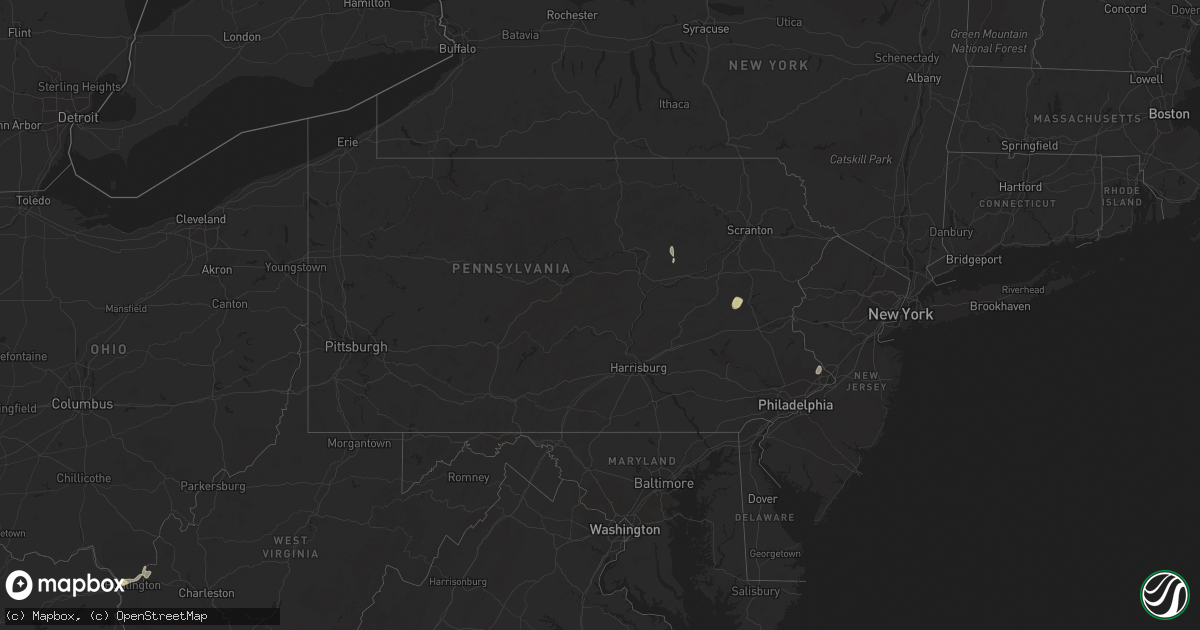
Hail Map in Pennsylvania on July 15, 2023
Get this storm
July 15 map
$229
one time, instant access
Download today. No call, no setup
Keep the $229
Bought the map and want the full workflow? Apply the entire $229 to a subscription within 7 days. None of it is wasted.
Every map, not just this one
This buys you this map. Subscription and you get every map we run, in the markets you choose from a few cities to whole states to nationwide. Plus real-time alerts the moment a storm fires.
Contact data
Name, contact info, occupancy, even credit band for addresses in the footprint. You go from where it hit to who to call.
Become the source they trust
Unlimited branding weather history reports on demand. You already have the documented answer ready for the property owner, and you are the one who showed up with it.
Property data and RoofTrace estimates
Pull up any address you have got, its value and the exact code rules for that jurisdiction, straight from One Click Code. Then RoofTrace estimates the squares, pitch, and roof value, priced the way you price.
Storm reports in Pennsylvania
Pennsylvania
| Date | Description |
|---|---|
| 07/15/20232:09 PM CDT | Delayed report... Received pictures of several trees down on island road in kintnersville. Time estimated. |
| 07/15/20232:09 PM CDT | Delayed report... Powerlines down on river road in holland twp. Time estimated from radar. |
| 07/15/20232:08 PM CDT | Delayed report... Powerlines were down in the area of sunday road and route 611. Time estimated. |
| 07/14/20238:03 PM CDT | Tree down partially blocking us-522. Time estimated by radar. |
| 07/14/20237:20 PM CDT | Multiple trees down in the biggertown area. Time estimated by radar. |
| 07/14/20237:18 PM CDT | Tree down partially blocking lanes of rt 42. Time estimated by radar. |
| 07/14/20237:16 PM CDT | Reports of multiple trees down in the vicinity of talmar rd. Time estimated by radar. |
| 07/14/20237:15 PM CDT | Several trees down near redners on route 209 in nesquehoning. Time estimated from radar. |
| 07/14/20237:15 PM CDT | Photo received of trees lying across e white bear drive blocking the road. Time estimated from radar. |
| 07/14/20237:15 PM CDT | Received photo of trees and wires down at mauch chunk lake. Time estimated from radar. |
| 07/14/20237:12 PM CDT | Reports of several trees down on laurel drive. Time estimated from radar. |
| 07/14/20237:04 PM CDT | Reports of trees and wires down near the intersection of mahoning drive and laurel road. Time estimated from radar. |
All States Impacted by Hail Map on July 15, 2023
Cities Impacted by Hail Map on July 15, 2023
- Fairfield, OH
- Cincinnati, OH
- New Raymer, CO
- South Point, OH
- Chesapeake, OH
- Masterson, TX
- Proctorville, OH
- Crown City, OH
- Scottown, OH
- Lesage, WV
- Aguilar, CO
- Trinidad, CO
- Cheyenne, WY
- Fe Warren Afb, WY
- Carr, CO
- Nunn, CO
- Miami, NM
- Colorado Springs, CO
- Boncarbo, CO
- Mescalero, NM
- Wagon Mound, NM
- Livermore, CO
- Bellvue, CO
- Drake, CO
- San Jose, NM
- Pecos, NM
- Ribera, NM
- Wellington, CO
- Fort Collins, CO
- Loveland, CO
- Lyons, CO
- Penrose, CO
- Raton, NM
- Model, CO
- Pierce, CO
- Trinchera, CO
- Longmont, CO
- Ocate, NM
- Pueblo, CO
- Weston, CO
- Moriarty, NM
- Kim, CO
- Branson, CO
- Carrizozo, NM
- Lincoln, NE
- Corona, NM
- Encino, NM
- Trementina, NM
- Valmora, NM
- Waterloo, IA
- Evansdale, IA
- Raymond, IA
- Jesup, IA
- Prescott, AR
- Greenwich, NJ
- Bent, NM
- La Luz, NM
- Greenville, MS
- Fife Lake, MI
- Franklin Park, NJ
- Kendall Park, NJ
- Chesterton, IN
- Florissant, CO
- Murfreesboro, AR
- Delight, AR
- Leroy, MI
- Milford, NE
- Seward, NE
- Warren, AR
- Banks, AR
- Hermitage, AR
- McBain, MI
- Marion, MI
- Fordyce, AR
- Little Rock, AR
- Hensley, AR
- Valparaiso, IN
- Portage, IN
- Hurley, NM
- Washington Crossing, PA
- Newtown, PA
- Morrisville, PA
- Langhorne, PA
- Chidester, AR
- Camden, AR
- Rosston, AR
- Bluff City, AR
- Glenwood, WV
- Ona, WV
- Mount Ulla, NC
- Kalkaska, MI
- Grayling, MI
- New Edinburg, AR
- Amity, AR
- Hanover, NM
- Mimbres, NM
- Red Feather Lakes, CO
- Bauxite, AR
- De Kalb, MS
- Little Rock, MS
- Sevierville, TN
- Datil, NM
- Rose City, MI
- Leola, AR
- Malvern, AR
- Victor, CO
- Lupton, MI
- Wiggins, CO
- Byers, CO
- Fort Morgan, CO
- Garita, NM
- Las Vegas, NM
- Folsom, NM
- Cuervo, NM
- Springer, NM
- Newkirk, NM
- Fort Laramie, WY
- Yoder, WY
- Lingle, WY
- Jay Em, WY
- Torrington, WY
- Grenville, NM
- Vaughn, NM
- Santa Rosa, NM
- Mills, NM
- Roy, NM
- Vernon, CO
- Wray, CO
- Saint Francis, KS
- Solano, NM
- Conchas Dam, NM
- Mosquero, NM
- Fort Sumner, NM
- Dalhart, TX
- Vega, TX
- Adrian, TX
- Mohawk, TN
- Greeneville, TN
- Midway, TN
- Mosheim, TN
- Afton, TN
- Happy, TX
- Sumner, IA
- Cleveland, NC
- Salisbury, NC
- Spring Grove, MN
- Parker, CO
- Waverly, IA
- Laporte, CO
- Deer Trail, CO
- Tularosa, NM
- Summit Hill, PA
- Andreas, PA
- Tamaqua, PA
- Lehighton, PA
- Jim Thorpe, PA
- Benton, PA
- Millville, PA
- Unityville, PA
- Mio, MI
- Des Moines, NM
- Leland, MS
- Cochran, GA
- Columbia, AL
- Ashford, AL
- Blue River, WI
- Hamburg, AR
- Crossett, AR
- Iva, SC
- Abbeville, SC
- Lowndesville, SC
- Calhoun Falls, SC
- Taylor, AR
- Warrenton, GA
- Norwood, GA
- Camak, GA
- Blakely, GA
- Chesnee, SC
- Inman, SC
- Leary, GA
- Newton, GA
- Albany, GA
- Lake Village, AR
- Lenoir, NC
- Hudson, NC
- Dermott, AR
- Hatch, NM
- McMillan, MI
- Dothan, AL
- Socorro, NM
- Kite, GA
- Keysville, GA
- Hephzibah, GA
- Salem, NM
- Silver City, MS
- Yazoo City, MS
- Louise, MS
- Belzoni, MS
- Eglin Afb, FL
- Fredericksburg, IA
- Wilson, TX
- Slaton, TX
- Post, TX
- Ralls, TX
- Lorenzo, TX
- Justiceburg, TX
- Snyder, TX
- Spur, TX
- Dickens, TX
- Jayton, TX
- Paducah, TX
- Girard, TX
- Old Glory, TX
- Aspermont, TX
- Afton, TX
- Roaring Springs, TX
- Matador, TX
- Mcadoo, TX
- Crosbyton, TX
- Brewster, NE
- Dunning, NE
- Purdum, NE
- Anselmo, NE
- Arnold, NE
- Halsey, NE
- Seneca, NE
- Thedford, NE
- Merna, NE
- Marquette, NE
- Cedar Rapids, NE
- Belgrade, NE
- Primrose, NE
- Rushville, NE
- Gordon, NE
- Cozad, NE
- Harrison, NE
- Angora, NE
- Palmer, NE
- Lexington, NE
- Clarks, NE
- Hordville, NE
- Fullerton, NE
- Central City, NE
- Genoa, NE
- Exeter, NE
- McCool Junction, NE
- Merriman, NE
- Aurora, NE
- Bayard, NE
- Spalding, NE
- Friona, TX
- Swainsboro, GA
- Minatare, NE
- Broken Bow, NE
- Oconto, NE
- Callaway, NE
- Mason City, NE
- Earth, TX
- Hereford, TX
- Polk, NE
- Chapman, NE
- Phillips, NE
- Taiban, NM
- Bradshaw, NE
- York, NE
- Saint Paul, NE
- Yeso, NM
- Amarillo, TX
- Ravenna, NE
- Rockville, NE
- Hazard, NE
- Diller, NE
- Odell, NE
- Burwell, NE
- Blue Springs, NE
- Beatrice, NE
- Albion, NE
- Saint Edward, NE
- Valentine, NE
- Johnstown, NE
- Elsmere, NE
- Hampton, NE
- Friend, NE
- Litchfield, NE
- Stromsburg, NE
- Benedict, NE
- Osceola, NE
- Archer, NE
- Jansen, NE
- Crawford, NE
- Elba, NE
- Wichita Falls, TX
- Iowa Park, TX
- Electra, TX


