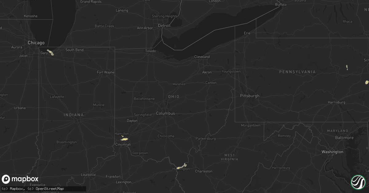
Hail Map in Ohio on July 15, 2023
Get this storm
July 15 map
$229
one time, instant access
Download today. No call, no setup
Keep the $229
Bought the map and want the full workflow? Apply the entire $229 to a subscription within 7 days. None of it is wasted.
Every map, not just this one
This buys you this map. Subscription and you get every map we run, in the markets you choose from a few cities to whole states to nationwide. Plus real-time alerts the moment a storm fires.
Contact data
Name, contact info, occupancy, even credit band for addresses in the footprint. You go from where it hit to who to call.
Become the source they trust
Unlimited branding weather history reports on demand. You already have the documented answer ready for the property owner, and you are the one who showed up with it.
Property data and RoofTrace estimates
Pull up any address you have got, its value and the exact code rules for that jurisdiction, straight from One Click Code. Then RoofTrace estimates the squares, pitch, and roof value, priced the way you price.
Storm reports in Ohio
Ohio
| Date | Description |
|---|---|
| 07/15/20233:50 PM CDT | Large tree branch 8 inch in diameter snapped on oh-45 on the south side of orwell. Several other smaller branches also down in the area. |
| 07/15/20232:13 PM CDT | A tree uprooted and minor damage to siding of a gas station on cleveland massillon rd just north of yellow creek rd. |
| 07/15/202312:50 PM CDT | Two trees down on gateway big branch road cr 35. Time estimated from radar. |
| 07/15/202312:48 PM CDT | Tree down along state route 243 near frys tack shop. Time estimated from radar. |
| 07/15/202312:33 PM CDT | Tree down across road near fourth street east. Time estimated from radar. |
| 07/15/20238:40 AM CDT | Tree downed on price road. Time estimated from radar. |
| 07/15/20238:07 AM CDT | One tree downed near franklin trenton road. |
| 07/15/20238:00 AM CDT | Tree limbs downed on springfield pike in woodlawn and wyoming. Time estimated from radar. |
All States Impacted by Hail Map on July 15, 2023
Cities Impacted by Hail Map on July 15, 2023
- Fairfield, OH
- Cincinnati, OH
- New Raymer, CO
- South Point, OH
- Chesapeake, OH
- Masterson, TX
- Proctorville, OH
- Crown City, OH
- Scottown, OH
- Lesage, WV
- Aguilar, CO
- Trinidad, CO
- Cheyenne, WY
- Fe Warren Afb, WY
- Carr, CO
- Nunn, CO
- Miami, NM
- Colorado Springs, CO
- Boncarbo, CO
- Mescalero, NM
- Wagon Mound, NM
- Livermore, CO
- Bellvue, CO
- Drake, CO
- San Jose, NM
- Pecos, NM
- Ribera, NM
- Wellington, CO
- Fort Collins, CO
- Loveland, CO
- Lyons, CO
- Penrose, CO
- Raton, NM
- Model, CO
- Pierce, CO
- Trinchera, CO
- Longmont, CO
- Ocate, NM
- Pueblo, CO
- Weston, CO
- Moriarty, NM
- Kim, CO
- Branson, CO
- Carrizozo, NM
- Lincoln, NE
- Corona, NM
- Encino, NM
- Trementina, NM
- Valmora, NM
- Waterloo, IA
- Evansdale, IA
- Raymond, IA
- Jesup, IA
- Prescott, AR
- Greenwich, NJ
- Bent, NM
- La Luz, NM
- Greenville, MS
- Fife Lake, MI
- Franklin Park, NJ
- Kendall Park, NJ
- Chesterton, IN
- Florissant, CO
- Murfreesboro, AR
- Delight, AR
- Leroy, MI
- Milford, NE
- Seward, NE
- Warren, AR
- Banks, AR
- Hermitage, AR
- McBain, MI
- Marion, MI
- Fordyce, AR
- Little Rock, AR
- Hensley, AR
- Valparaiso, IN
- Portage, IN
- Hurley, NM
- Washington Crossing, PA
- Newtown, PA
- Morrisville, PA
- Langhorne, PA
- Chidester, AR
- Camden, AR
- Rosston, AR
- Bluff City, AR
- Glenwood, WV
- Ona, WV
- Mount Ulla, NC
- Kalkaska, MI
- Grayling, MI
- New Edinburg, AR
- Amity, AR
- Hanover, NM
- Mimbres, NM
- Red Feather Lakes, CO
- Bauxite, AR
- De Kalb, MS
- Little Rock, MS
- Sevierville, TN
- Datil, NM
- Rose City, MI
- Leola, AR
- Malvern, AR
- Victor, CO
- Lupton, MI
- Wiggins, CO
- Byers, CO
- Fort Morgan, CO
- Garita, NM
- Las Vegas, NM
- Folsom, NM
- Cuervo, NM
- Springer, NM
- Newkirk, NM
- Fort Laramie, WY
- Yoder, WY
- Lingle, WY
- Jay Em, WY
- Torrington, WY
- Grenville, NM
- Vaughn, NM
- Santa Rosa, NM
- Mills, NM
- Roy, NM
- Vernon, CO
- Wray, CO
- Saint Francis, KS
- Solano, NM
- Conchas Dam, NM
- Mosquero, NM
- Fort Sumner, NM
- Dalhart, TX
- Vega, TX
- Adrian, TX
- Mohawk, TN
- Greeneville, TN
- Midway, TN
- Mosheim, TN
- Afton, TN
- Happy, TX
- Sumner, IA
- Cleveland, NC
- Salisbury, NC
- Spring Grove, MN
- Parker, CO
- Waverly, IA
- Laporte, CO
- Deer Trail, CO
- Tularosa, NM
- Summit Hill, PA
- Andreas, PA
- Tamaqua, PA
- Lehighton, PA
- Jim Thorpe, PA
- Benton, PA
- Millville, PA
- Unityville, PA
- Mio, MI
- Des Moines, NM
- Leland, MS
- Cochran, GA
- Columbia, AL
- Ashford, AL
- Blue River, WI
- Hamburg, AR
- Crossett, AR
- Iva, SC
- Abbeville, SC
- Lowndesville, SC
- Calhoun Falls, SC
- Taylor, AR
- Warrenton, GA
- Norwood, GA
- Camak, GA
- Blakely, GA
- Chesnee, SC
- Inman, SC
- Leary, GA
- Newton, GA
- Albany, GA
- Lake Village, AR
- Lenoir, NC
- Hudson, NC
- Dermott, AR
- Hatch, NM
- McMillan, MI
- Dothan, AL
- Socorro, NM
- Kite, GA
- Keysville, GA
- Hephzibah, GA
- Salem, NM
- Silver City, MS
- Yazoo City, MS
- Louise, MS
- Belzoni, MS
- Eglin Afb, FL
- Fredericksburg, IA
- Wilson, TX
- Slaton, TX
- Post, TX
- Ralls, TX
- Lorenzo, TX
- Justiceburg, TX
- Snyder, TX
- Spur, TX
- Dickens, TX
- Jayton, TX
- Paducah, TX
- Girard, TX
- Old Glory, TX
- Aspermont, TX
- Afton, TX
- Roaring Springs, TX
- Matador, TX
- Mcadoo, TX
- Crosbyton, TX
- Brewster, NE
- Dunning, NE
- Purdum, NE
- Anselmo, NE
- Arnold, NE
- Halsey, NE
- Seneca, NE
- Thedford, NE
- Merna, NE
- Marquette, NE
- Cedar Rapids, NE
- Belgrade, NE
- Primrose, NE
- Rushville, NE
- Gordon, NE
- Cozad, NE
- Harrison, NE
- Angora, NE
- Palmer, NE
- Lexington, NE
- Clarks, NE
- Hordville, NE
- Fullerton, NE
- Central City, NE
- Genoa, NE
- Exeter, NE
- McCool Junction, NE
- Merriman, NE
- Aurora, NE
- Bayard, NE
- Spalding, NE
- Friona, TX
- Swainsboro, GA
- Minatare, NE
- Broken Bow, NE
- Oconto, NE
- Callaway, NE
- Mason City, NE
- Earth, TX
- Hereford, TX
- Polk, NE
- Chapman, NE
- Phillips, NE
- Taiban, NM
- Bradshaw, NE
- York, NE
- Saint Paul, NE
- Yeso, NM
- Amarillo, TX
- Ravenna, NE
- Rockville, NE
- Hazard, NE
- Diller, NE
- Odell, NE
- Burwell, NE
- Blue Springs, NE
- Beatrice, NE
- Albion, NE
- Saint Edward, NE
- Valentine, NE
- Johnstown, NE
- Elsmere, NE
- Hampton, NE
- Friend, NE
- Litchfield, NE
- Stromsburg, NE
- Benedict, NE
- Osceola, NE
- Archer, NE
- Jansen, NE
- Crawford, NE
- Elba, NE
- Wichita Falls, TX
- Iowa Park, TX
- Electra, TX


