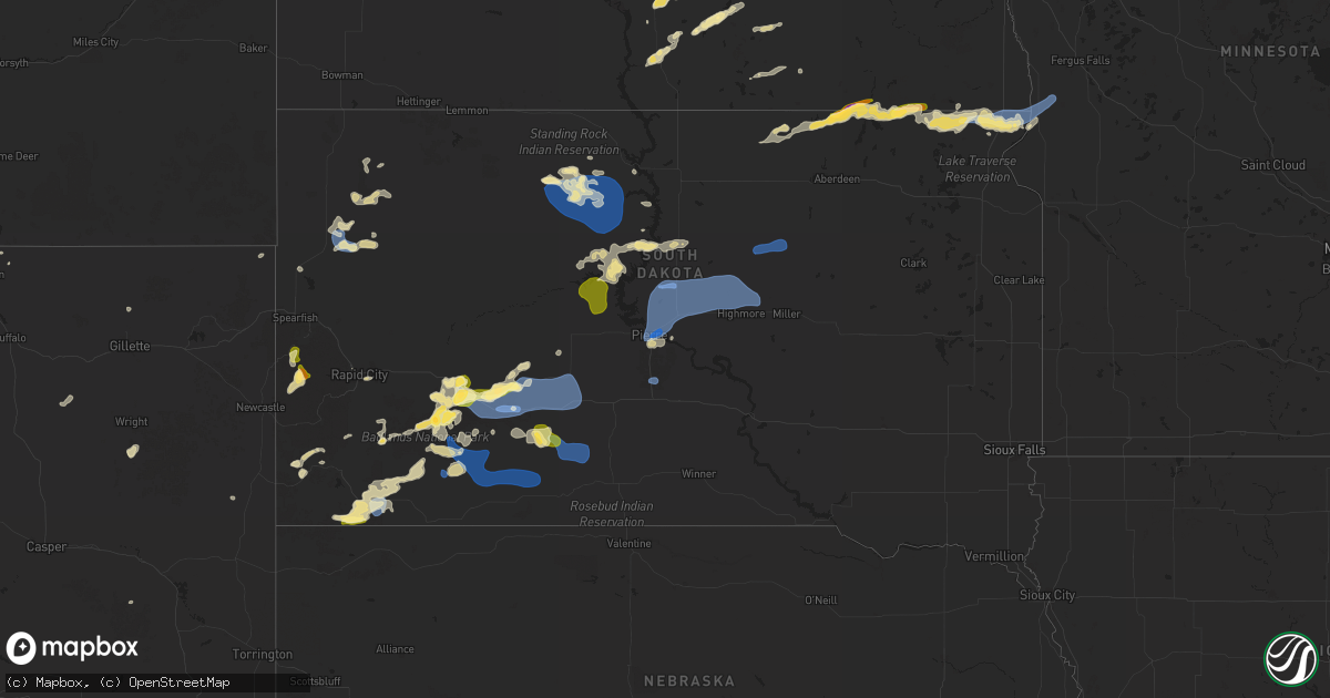
Hail Map in South Dakota on July 14, 2025
Get this storm
July 14 map
$229
one time, instant access
Download today. No call, no setup
Keep the $229
Bought the map and want the full workflow? Apply the entire $229 to a subscription within 7 days. None of it is wasted.
Every map, not just this one
This buys you this map. Subscription and you get every map we run, in the markets you choose from a few cities to whole states to nationwide. Plus real-time alerts the moment a storm fires.
Contact data
Name, contact info, occupancy, even credit band for addresses in the footprint. You go from where it hit to who to call.
Become the source they trust
Unlimited branding weather history reports on demand. You already have the documented answer ready for the property owner, and you are the one who showed up with it.
Property data and RoofTrace estimates
Pull up any address you have got, its value and the exact code rules for that jurisdiction, straight from One Click Code. Then RoofTrace estimates the squares, pitch, and roof value, priced the way you price.
Storm reports in South Dakota
South Dakota
| Date | Description |
|---|---|
| 07/14/20256:55 PM CDT | A local report indicates 60 MPH wind near Sharps Corner |
| 07/14/20256:40 PM CDT | A local report indicates 60 MPH wind near 2 NE Kadoka |
| 07/14/20256:31 PM CDT | A local report indicates 62 MPH wind near 12 E Oelrichs |
| 07/14/20256:20 PM CDT | A local report indicates 58 MPH wind near 10 ESE Oelrichs |
| 07/14/20255:55 PM CDT | A local report indicates 68 MPH wind near 3 E Philip |
| 07/14/20255:51 PM CDT | A local report indicates 93 MPH wind near 4 E Cactus Flat |
| 07/14/20255:46 PM CDT | A local report indicates 88 MPH wind near 4 E Cactus Flat |
| 07/14/20255:46 PM CDT | Semi blown over on i-90 near mm146. |
| 07/14/20255:40 PM CDT | A local report indicates 71 MPH wind near 8 S Wall |
| 07/14/20255:20 PM CDT | A local report indicates 60 MPH wind near Wall |
| 07/14/20255:10 PM CDT | A local report indicates 60 MPH wind near Wall |
| 07/14/20252:00 AM CDT | Scattered crop damage. |
| 07/14/20251:36 AM CDT | Mesonet station 58 victor |
| 07/14/20251:14 AM CDT | Report that calf shelters were thrown by the wind into fence. |
| 07/14/20251:14 AM CDT | Report that calf shelters were thrown |
| 07/13/202511:50 PM CDT | Fertilizer bin tipped over by wind... Crop damage from wind and hail. |
| 07/13/20259:50 PM CDT | A local report indicates 61 MPH wind near 1 NE Midland |
| 07/13/20259:45 PM CDT | A local report indicates 67 MPH wind near 3 ENE Midland |
| 07/13/20259:35 PM CDT | A local report indicates 59 MPH wind near 7 WSW Hoover |
| 07/13/20259:35 PM CDT | A local report indicates 69 MPH wind near 1 NE Midland |
| 07/13/20259:25 PM CDT | Mesonet station 13 vivian |
| 07/13/20259:25 PM CDT | A local report indicates 73 MPH wind near 1 NE Midland |
| 07/13/20259:25 PM CDT | A local report indicates 59 MPH wind near 7 WSW Hoover |
| 07/13/20259:20 PM CDT | A local report indicates 58 MPH wind near 7 WSW Hoover |
| 07/13/20259:20 PM CDT | A local report indicates 62 MPH wind near 1 NE Midland |
| 07/13/20259:02 PM CDT | A local report indicates 63 MPH wind near 3 ENE Midland |
| 07/13/20259:00 PM CDT | Estimates 50-60 mph wind on 180th street 5 miles west of hwy 47. |
| 07/13/20258:51 PM CDT | Mesonet station 293 timber lake |
| 07/13/20258:51 PM CDT | Flom weatherlink station. |
| 07/13/20258:51 PM CDT | Mesonet station 293 timbe |
| 07/13/20258:45 PM CDT | A local report indicates 71 MPH wind near 1 NE Midland |
| 07/13/20258:45 PM CDT | Mesonet station tims2 timber lake |
| 07/13/20258:45 PM CDT | A local report indicates 63 MPH wind near 4 E Cactus Flat |
| 07/13/20258:40 PM CDT | Mesonet station 178 trail city |
| 07/13/20258:30 PM CDT | Power lines down blocking the road. Estimated wind near 100 mph. |
| 07/13/20258:11 PM CDT | Asos station kpir pierre muni ap. Trained spotter also reports trees down in pierre. |
| 07/13/20258:07 PM CDT | Asos station kpir pierre muni ap. Initial gust of 82 mph at asos... Which is asos time of peak wind. Another gust of 82 mph occurred at 811 pm cdt. |
| 07/13/20257:50 PM CDT | Penny to quarter sized hail fell. Estimated time from radar. |
| 07/13/20257:50 PM CDT | Mesonet station onms2 onida 13wsw |
| 07/13/20257:26 PM CDT | A local report indicates 66 MPH wind near 9 ENE Belvidere |
| 07/13/20257:00 PM CDT | A local report indicates 1.00 inch wind near 5 WNW Mission Ridge |
All States Impacted by Hail Map on July 14, 2025
Cities Impacted by Hail Map on July 14, 2025
- Okeechobee, FL
- North Augusta, SC
- Mescalero, NM
- Douglas, WY
- Wyalusing, PA
- Florahome, FL
- Happy, TX
- Tulia, TX
- Green Cove Springs, FL
- Saint Johns, FL
- Saint Augustine, FL
- Alamogordo, NM
- Metter, GA
- Lockney, TX
- Columbia, PA
- Mayhill, NM
- Fort McCoy, FL
- Kissimmee, FL
- Davenport, FL
- Cloudcroft, NM
- Florissant, CO
- Ralls, TX
- Clinton, LA
- Floydada, TX
- Saint George, GA
- Ocala, FL
- Claude, TX
- Bethune, SC
- Ashland, ME
- Fort Meade, FL
- White Oak, GA
- Waynesville, GA
- Sopchoppy, FL
- Crosbyton, TX
- Cotopaxi, CO
- Kress, TX
- Rapid City, SD
- Lance Creek, WY
- Brooklet, GA
- Gonzales, TX
- Lorenzo, TX
- Guyton, GA
- Box Elder, SD
- Garnett, SC
- Kiowa, CO
- Pembroke, GA
- Fort Stewart, GA
- Ludowici, GA
- Webster, FL
- Slaton, TX
- Brooksville, FL
- Wilson, TX
- Wall, SD
- Quinn, SD
- Floral City, FL
- Inverness, FL
- Hinesville, GA
- Edgemont, SD
- Westcliffe, CO
- Plainview, TX
- Black Hawk, SD
- Ramah, CO
- Corona, NM
- Brownfield, TX
- Dade City, FL
- Lubbock, TX
- Agate, CO
- Bennett, CO
- Elbert, CO
- Harrisburg, NE
- Inglis, FL
- Scenic, SD
- Calhan, CO
- Byers, CO
- Custer, SD
- Fairburn, SD
- Pine Ridge, SD
- Kadoka, SD
- Interior, SD
- Blackville, SC
- Hot Springs, SD
- Cedar Key, FL
- Oelrichs, SD
- Chiefland, FL
- Wolfforth, TX
- Burton, TX
- Beulah, CO
- Pueblo, CO
- Carpenter, WY
- Cheyenne, WY
- Grover, CO
- Levelland, TX
- Ropesville, TX
- Bryans Road, MD
- Hale Center, TX
- Dimmitt, TX
- Yeso, NM
- Denmark, SC
- Philip, SD
- Ault, CO
- San Antonio, FL
- Wesley Chapel, FL
- Land O'Lakes, FL
- Spring Hill, FL
- Smithville, TX
- Ledbetter, TX
- Wasta, SD
- Burns, WY
- Oral, SD
- Smithwick, SD
- Simla, CO
- Old Town, FL
- Lutz, FL
- Kyle, SD
- Wanblee, SD
- Yoder, CO
- New Underwood, SD
- Owanka, SD
- Olar, SC
- Clovis, NM
- Houston, TX
- Earth, TX
- Bamberg, SC
- Terreton, ID
- Monroe, NC
- Elizabeth, CO
- Colorado Springs, CO
- Pine Bluffs, WY
- Hermosa, SD
- Allen, SD
- Porcupine, SD
- Hill City, SD
- Lead, SD
- Albin, WY
- Cross City, FL
- Briggsdale, CO
- Tampa, FL
- Fort Pierre, SD
- Gillette, WY
- Harrison, NE
- Hayes, SD
- Eagle Butte, SD
- Odonnell, TX
- Mitchell, NE
- La Plata, MD
- Ribera, NM
- Spring, TX
- Lamesa, TX
- Crawford, NE
- Faulkner, MD
- Bel Alton, MD
- Newburg, MD
- Midland, SD
- Tahoka, TX
- Muleshoe, TX
- Martin, SD
- Long Valley, SD
- White River, SD
- Norris, SD
- Belvidere, SD
- Lyman, NE
- Gering, NE
- Mayo, FL
- Spencer, ID
- Cannon Afb, NM
- Chaptico, MD
- Avenue, MD
- Bushwood, MD
- Marshville, NC
- Charlotte Hall, MD
- Mechanicsville, MD
- Pierre, SD
- Las Vegas, NM
- Marsland, NE
- Oakboro, NC
- Onida, SD
- Isabel, SD
- Timber Lake, SD
- Saint Anthony, ID
- Glencross, SD
- Fowler, CO
- Wakpala, SD
- Indian Head, MD
- Marbury, MD
- Blunt, SD
- Harrold, SD
- Trail City, SD
- McLaughlin, SD
- Whitehorse, SD
- Okaton, SD
- Cadwell, GA
- Gettysburg, SD
- Bushnell, NE
- Eaton, CO
- Troy, NC
- Saint Johns, AZ
- New Raymer, CO
- Padroni, CO
- Kimball, NE
- Dix, NE
- Peetz, CO
- Sidney, NE
- Termo, CA
- Ridgeview, SD
- Seneca, SD
- Faulkton, SD
- Belle Fourche, SD
- Newell, SD
- Highmore, SD
- Holabird, SD
- Ree Heights, SD
- Miller, SD
- Kaycee, WY
- Vivian, SD
- Thonotosassa, FL
- Galeton, CO
- Big Sandy, MT
- Box Elder, MT
- Buffalo, SD
- Frederick, SD
- Hurdsfield, ND
- Chaseley, ND
- Harvey, ND
- Ellendale, ND
- Oakes, ND
- Leola, SD
- Estill, SC
- Clements, MD
- Story, WY
- Fort Benton, MT
- Sheridan, WY
- Linton, ND
- Lehr, ND
- Amelia Court House, VA
- Bowdon, ND
- Fessenden, ND
- New Rockford, ND
- Warwick, ND
- Tolna, ND
- Mchenry, ND
- Sykeston, ND
- Reva, SD
- Loma, MT
- Kintyre, ND
- Moffit, ND
- Havre, MT
- Fredonia, ND
- Braddock, ND
- Hazelton, ND
- Buffalo, WY
- Pekin, ND
- Britton, SD
- Napoleon, ND
- Prairie City, SD
- Hecla, SD
- Sheyenne, ND
- Petersburg, ND
- Cogswell, ND
- Niagara, ND
- Gackle, ND
- Goodrich, ND
- Cathay, ND
- Stanton, ND
- New Salem, ND
- Center, ND
- Forman, ND
- Inkster, ND
- Lisco, NE
- Roundup, MT
- Mercer, ND
- Washburn, ND
- Carrington, ND
- Kulm, ND
- Streeter, ND
- Tappen, ND
- Mcclusky, ND
- Forest River, ND
- Gilby, ND
- Havana, ND
- Edgeley, ND
- Mcville, ND
- Lakota, ND
- Michigan, ND
- Underwood, ND
- Jud, ND
- Chinook, MT
- Minto, ND
- Aneta, ND
- Fordville, ND
- Hazen, ND
- Beulah, ND
- Larimore, ND
- Grace City, ND
- Wilton, ND
- Buchanan, ND
- Courtenay, ND
- Edinburg, ND
- Hoople, ND
- Crystal, ND
- Argyle, MN
- Veblen, SD
- Wimbledon, ND
- Park River, ND
- Claire City, SD
- New Effington, SD
- Saint Thomas, ND
- Forest Grove, MT
- Lidgerwood, ND
- Rogers, ND
- Valley City, ND
- Circle, MT
- Pisek, ND
- Stephen, MN
- Strandquist, MN
- Sisseton, SD
- Oslo, MN
- Grygla, MN
- Hankinson, ND
- Manvel, ND
- Mekinock, ND
- Rosholt, SD
- Fairmount, ND
- Wheaton, MN
- Lake City, SD
- Tintah, MN
- Nashua, MN
- Campbell, MN
- Kelliher, MN
- Big Falls, MN
- Bloomfield, MT
- Lindsay, MT
- Hines, MN
- Blackduck, MN
- Northome, MN
- Orr, MN
- Glendive, MT
- Mizpah, MN
- Wibaux, MT
- San Jose, NM
- Pecos, NM
- Cook, MN
- Wirt, MN
- Tower, MN
- Coleharbor, ND
- Michigamme, MI
- Snowville, UT
- Malad City, ID
- Holbrook, ID
- Downey, ID
- Mccammon, ID
- Lava Hot Springs, ID
- Arimo, ID
- Grace, ID
- Ririe, ID
- Swan Valley, ID


