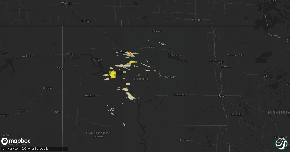
Hail Map in North Dakota on July 14, 2017
Get this storm
July 14 map
$229
one time, instant access
Download today. No call, no setup
Keep the $229
Bought the map and want the full workflow? Apply the entire $229 to a subscription within 7 days. None of it is wasted.
Every map, not just this one
This buys you this map. Subscription and you get every map we run, in the markets you choose from a few cities to whole states to nationwide. Plus real-time alerts the moment a storm fires.
Contact data
Name, contact info, occupancy, even credit band for addresses in the footprint. You go from where it hit to who to call.
Become the source they trust
Unlimited branding weather history reports on demand. You already have the documented answer ready for the property owner, and you are the one who showed up with it.
Property data and RoofTrace estimates
Pull up any address you have got, its value and the exact code rules for that jurisdiction, straight from One Click Code. Then RoofTrace estimates the squares, pitch, and roof value, priced the way you price.
Storm reports in North Dakota
North Dakota
| Date | Description |
|---|---|
| 07/14/20176:58 PM CDT | Measured at mandan airport by automated observing system. |
| 07/14/20176:07 PM CDT | A local report indicates 58 MPH wind near 6 SSE CENTER |
| 07/14/20175:58 PM CDT | Also receiving dime size hail. Wind and hail ongoing at time this report sent. Corrected for duration of report. |
| 07/14/20175:11 PM CDT | Report relayed to nws from media. |
| 07/14/20175:11 PM CDT | Correction to location from voltaire to 11 south voltaire |
| 07/14/20174:55 PM CDT | Lasted 20 minutes with a few as big as ping pong balls. Temperature fell 41 degrees in one half hour... From 104 to 63. |
| 07/14/20174:20 PM CDT | Relayed through broadcast media. |
| 07/13/20177:00 PM CDT | Also accumulated pea size hail. Delayed report. |
All States Impacted by Hail Map on July 14, 2017
Cities Impacted by Hail Map on July 14, 2017
- Granville, ND
- Elgin, ND
- Velva, ND
- Voltaire, ND
- Peach Bottom, PA
- Conowingo, MD
- Nottingham, PA
- Delta, PA
- Whiteford, MD
- Rising Sun, MD
- Scotland Neck, NC
- Norwich, ND
- Drasco, AR
- Chesapeake, VA
- Garber, OK
- Franklin, VA
- Zuni, VA
- Courtland, VA
- Sedley, VA
- Wakefield, VA
- Ivor, VA
- Mountain View, AR
- Shirley, AR
- Pfafftown, NC
- Tobaccoville, NC
- Castleton, VA
- Washington, VA
- Amissville, VA
- Beulah, ND
- Mandan, ND
- Salem, NJ
- Middletown, DE
- Woodstown, NJ
- Delaware City, DE
- New Castle, DE
- Pennsville, NJ
- New Salem, ND
- Fremont, MO
- Van Buren, MO
- Sawyer, ND
- Minot, ND
- Suffolk, VA
- Roseglen, ND
- Golden Valley, ND
- Monette, AR
- Lake City, AR
- Paragould, AR
- Brookland, AR
- Annapolis, MD
- Hazen, ND
- Garrison, ND
- Marland, OK
- Billings, OK
- Red Rock, OK
- Black Canyon City, AZ
- Bishopville, MD
- Selbyville, DE
- Miami, AZ
- Oxford, PA
- Lincoln University, PA
- Elkton, MD
- Landenberg, PA
- Moorcroft, WY
- Clinton, AR
- Lambsburg, VA
- Galax, VA
- Bismarck, ND
- Anamoose, ND
- Martin, ND
- McLaughlin, SD
- McIntosh, SD
- Garrison, TX
- Denhoff, ND
- Goodrich, ND
- Eden, MD
- Ulysses, KS
- Penns Grove, NJ
- Arcadia, LA
- Georgetown, DE
- Seaford, DE
- Bridgeville, DE
- Dagsboro, DE
- Millsboro, DE
- Laurel, DE
- Max, ND
- Douglas, ND
- Center, ND
- Wilton, ND
- Timpson, TX
- Hugoton, KS
- Liberal, KS
- Young, AZ
- Payson, AZ
- Rush, CO
- Greenville, SC
- Hunter, OK
- Summertown, TN
- Ramah, CO
- Center, TX
- Panama City, FL
- Sibley, LA
- Bismarck, AR
- Jonesboro, AR
- Winona, MO
- Panama City Beach, FL
- Lynn Haven, FL
- Plains, KS
- Forgan, OK
- Meade, KS
- Belgrade, MT
- Asheville, NC
- Mays Landing, NJ
- Mooreland, OK
- Tilghman, MD
- Sherwood, MD
- Strawberry, AR
- Easton, MD
- Marion, NC
- Coushatta, LA
- Hammonton, NJ
- Bernice, LA
- Bear, DE
- Fairview, NC
- Dunnellon, FL
- Buena, NJ
- Richland, NJ
- Newtonville, NJ
- Gibsland, LA
- Mount Pleasant, TN
- Hall Summit, LA
- Bunker, MO
- Pencil Bluff, AR
- Vienna, MD
- Coleharbor, ND
- Des Lacs, ND
- Burlington, ND
- Mcdaniel, MD
- Wittman, MD
- Saint Michaels, MD
- Claiborne, MD
- Berlin, MD
- Whaleyville, MD
- Zap, ND
- Claudville, VA
- Ararat, VA
- Windsor, VA
- Upperville, VA
- Zebulon, NC
- Middlesex, NC
- Stevensville, MD
- Neavitt, MD
- Hayden, AL
- Flagstaff, AZ
- Grottoes, VA
- Port Republic, VA
- Benedict, ND
- San Augustine, TX
- Edgewater, MD
- Williford, AR
- Hardy, AR
- Delmont, NJ
- Port Norris, NJ
- Leesburg, NJ
- Dorchester, NJ
- Heislerville, NJ
- Millville, NJ
- Mohawk, WV
- Baisden, WV
- Ruso, ND
- Farmerville, LA
- Spearsville, LA
- Zachary, LA
- King George, VA
- Fessenden, ND
- Alloway, NJ
- Bridgeton, NJ
- Elmer, NJ
- New Leipzig, ND
- Paris, AR
- Roxobel, NC
- Delaplane, VA
- Shreveport, LA
- Morriston, FL
- Bronson, FL
- Inglis, FL
- Turtle Lake, ND
- Capron, VA
- Marshall, TX
- Wilmington, DE
- Sea Isle City, NJ
- Lamont, OK
- Dora, MO
- Mount Crawford, VA
- Weyers Cave, VA
- Drake, ND
- Spotsylvania, VA
- Underwood, ND
- Bono, AR
- Havana, AR
- Bowdon, ND
- Hayden, AZ
- Gold Canyon, AZ
- Frankford, DE
- Harvey, ND
- Hot Springs National Park, AR
- Lost Creek, KY
- Wolford, ND
- Queenstown, MD
- Chester, MD
- Grasonville, MD
- Dodge, ND
- Davidsonville, MD
- Bowie, MD
- Harwood, MD
- Gambrills, MD
- Riva, MD
- Johnson, KS
- Westminster, SC
- Water View, VA
- Jamaica, VA
- Evangeline, LA
- Jennings, LA
- Middle River, MD
- Camden, NY
- Bernhards Bay, NY
- Prescott, AZ
- Glynn, LA
- Erwinville, LA
- Cando, ND
- Willow Street, PA
- Holtwood, PA
- Pequea, PA
- Quarryville, PA
- Kirkwood, PA
- New Providence, PA
- Christiana, PA
- Yellow Spring, WV
- Karlsruhe, ND
- Dubach, LA
- Essex, MD
- Memphis, TN
- Ozone, AR
- Clarksville, AR
- Avalon, NJ
- Cape May Court House, NJ
- Woodbine, NJ
- Ocean View, NJ
- Washington, DC
- Grandview, TN
- Newark, DE
- Saint Georges, DE
- Pedricktown, NJ
- Port Penn, DE
- Clopton, AL
- Newville, AL
- Terlton, OK
- Parkville, MD
- Baltimore, MD
- Nottingham, MD
- Rosedale, MD
- Franklinville, NJ
- Medford, OK
- Deer Creek, OK
- West Monroe, NY
- Parish, NY
- Smithfield, VA
- Belleville, AR
- Danville, AR
- Sherwood, AR
- Fletcher, NC
- Clifton, TN
- Avondale, PA
- Crownsville, MD
- Dennard, AR
- Leslie, AR
- Morganton, NC
- Portsmouth, VA
- Harriman, TN
- Newfield, NJ
- Williamstown, NJ
- Landisville, NJ
- Weaverville, NC
- Beech Grove, AR
- Orlando, OK
- Marshall, OK
- Capon Bridge, WV
- Knotts Island, NC
- Wendell, NC
- Butte, ND
- Ringgold, LA
- Willow City, ND
- Bisbee, ND
- Leeds, ND
- York, ND
- New Iberia, LA
- Egg Harbor City, NJ


