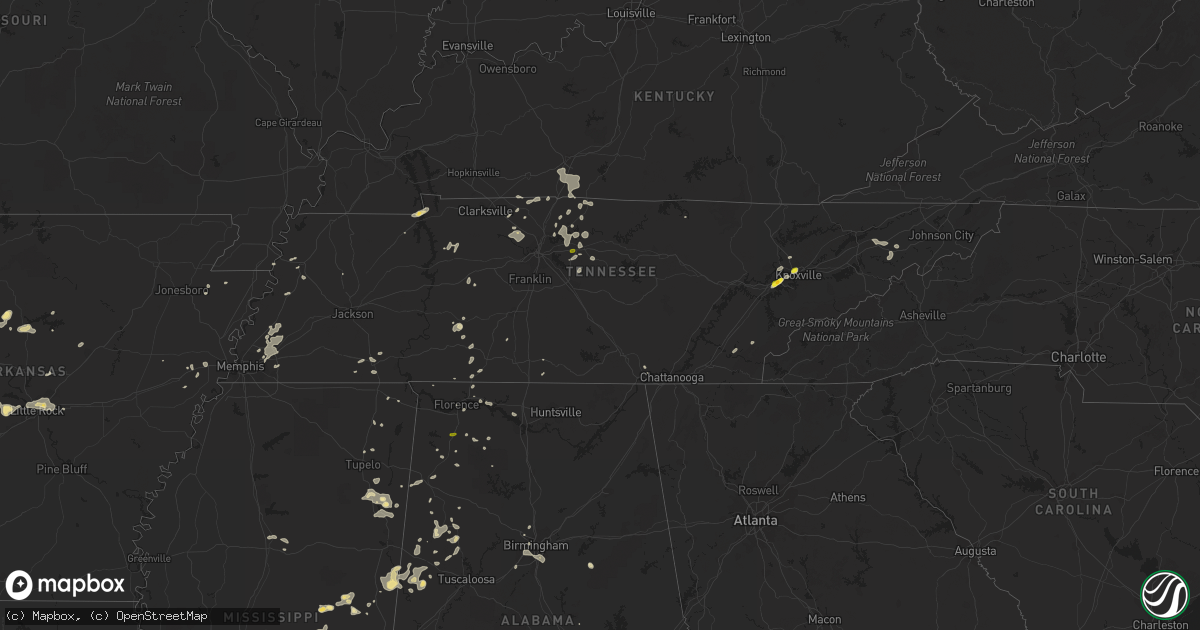
Hail Map in Tennessee on July 14, 2016
Get this storm
July 14 map
$229
one time, instant access
Download today. No call, no setup
Keep the $229
Bought the map and want the full workflow? Apply the entire $229 to a subscription within 7 days. None of it is wasted.
Every map, not just this one
This buys you this map. Subscription and you get every map we run, in the markets you choose from a few cities to whole states to nationwide. Plus real-time alerts the moment a storm fires.
Contact data
Name, contact info, occupancy, even credit band for addresses in the footprint. You go from where it hit to who to call.
Become the source they trust
Unlimited branding weather history reports on demand. You already have the documented answer ready for the property owner, and you are the one who showed up with it.
Property data and RoofTrace estimates
Pull up any address you have got, its value and the exact code rules for that jurisdiction, straight from One Click Code. Then RoofTrace estimates the squares, pitch, and roof value, priced the way you price.
Storm reports in Tennessee
Tennessee
| Date | Description |
|---|---|
| 07/14/20166:05 PM CDT | A tree down near tusculum. |
| 07/14/20165:54 PM CDT | One tree down in greeneville |
| 07/14/20164:04 PM CDT | Multiple trees reported down across the county |
| 07/14/20164:00 PM CDT | Multiple large limbs down along edgewood avenue with estimated winds of 60 mph. |
| 07/14/20163:56 PM CDT | Tree down on a home via social media. |
| 07/14/20163:45 PM CDT | A couple of tree reported down in monroe county |
| 07/14/20163:40 PM CDT | Tree on car |
| 07/14/20163:40 PM CDT | A local report indicates 1.50 inch wind near 4 NE FARRAGUT |
| 07/14/20163:31 PM CDT | A couple of large limbs down. |
| 07/14/20163:30 PM CDT | Multiple trees down across southern portions of the county |
| 07/14/20163:26 PM CDT | A local report indicates 1.00 inch wind near FARRAGUT |
| 07/14/20163:15 PM CDT | A few trees down across the county from 4 to 420pm |
| 07/14/20162:00 PM CDT | One inch hail near 109 just south of i-40 |
| 07/14/20162:00 PM CDT | Part of tree down on doak road in manchester. Time estimated based on radar. |
| 07/14/20161:52 PM CDT | Corrected location and time. Tspotter twitter photo showed tree down on house on hartsville pike. Time estimated based on radar. |
| 07/14/20161:38 PM CDT | Tspotter twitter photo showed tree down on house on hartsville pike. Time estimated based on radar. |
| 07/14/201612:17 PM CDT | A picture of a fallen tree was posted to office facebook page. |
| 07/14/201612:15 PM CDT | A tree down reported in orlinda. |
| 07/14/201611:42 AM CDT | Tree reported down on carter road. |
| 07/14/201611:40 AM CDT | Fire chief reports at least 3 trees down on hwy 224. |
| 07/14/201611:30 AM CDT | A tree was reported down on oak road. |
| 07/14/201611:30 AM CDT | A tree was reported down on hwy 48 north. |
| 07/14/201611:30 AM CDT | A tree down reported in adams. |
| 07/14/201611:30 AM CDT | A tree was reported down on pinewood road. |
| 07/14/201610:45 AM CDT | One tree reported down on weaks cemetary road and freeman fielders road. The tree is blocking the road. |
All States Impacted by Hail Map on July 14, 2016
Cities Impacted by Hail Map on July 14, 2016
- Eldorado, OK
- Gould, OK
- Bowman, ND
- Pueblo, CO
- Kingfisher, OK
- Claude, TX
- Mer Rouge, LA
- Sand Springs, OK
- Cleveland, OK
- Mannford, OK
- Terlton, OK
- Cody, NE
- Pine Ridge, SD
- Manderson, SD
- Lakeside, NE
- Alliance, NE
- Ellsworth, NE
- Hamilton, KS
- Kyle, SD
- Scenic, SD
- Custer City, OK
- Murfreesboro, AR
- Childress, TX
- Quanah, TX
- Mentone, TX
- Floydada, TX
- Petersburg, TX
- Lockney, TX
- Tahlequah, OK
- Preston, MS
- Midland, TX
- Hammon, OK
- Leedey, OK
- Cheyenne, OK
- Kit Carson, CO
- Hastings, FL
- East Palatka, FL
- San Mateo, FL
- Blackwell, OK
- Braman, OK
- Nardin, OK
- Pocasset, OK
- Chickasha, OK
- Gordo, AL
- Carrollton, AL
- Jessieville, AR
- Taloga, OK
- Hendersonville, TN
- Amory, MS
- Aberdeen, MS
- Reva, SD
- Belleville, IL
- Model, CO
- Prairie City, SD
- Madison, KS
- Batesland, SD
- Valentine, NE
- Kilgore, NE
- Wanblee, SD
- Martin, SD
- Merriman, NE
- Tuthill, SD
- Porcupine, SD
- Nenzel, NE
- Thedford, NE
- Allen, SD
- Johnstown, NE
- Hodgen, OK
- Alpine, AL
- Talladega, AL
- Gladstone, NM
- Faith, SD
- Eufaula, OK
- Heavener, OK
- Groom, TX
- Oshkosh, NE
- Bingham, NE
- Hyannis, NE
- Ashby, NE
- Pleasant View, TN
- Ashland City, TN
- Seibert, CO
- Flagler, CO
- Stratton, CO
- Vona, CO
- Erie, KS
- Galesburg, KS
- Parsons, KS
- Patriot, IN
- Rising Sun, IN
- Kermit, TX
- Caneyville, KY
- Weleetka, OK
- Henryetta, OK
- Dickens, TX
- Maize, KS
- Robards, KY
- Circle, MT
- Haven, KS
- Inola, OK
- Bristow, IN
- Saint Meinrad, IN
- Seagraves, TX
- Broken Bow, OK
- Wagoner, OK
- Porter, OK
- Coweta, OK
- Nocona, TX
- Waldron, AR
- Farragut, TN
- Knoxville, TN
- Franklin, LA
- Millington, TN
- Arlington, TN
- Memphis, TN
- Brownfield, TX
- Lemmon, SD
- Meadow, SD
- Mansfield, AR
- Huntington, AR
- Yale, OK
- Hayes Center, NE
- Colorado Springs, CO
- Cedar Hill, TN
- Hamilton, MS
- Brewster, NE
- Anselmo, NE
- Erin, TN
- Waverly, TN
- Osage, OK
- Prue, OK
- Wilburton, OK
- Hartshorne, OK
- Groton, VT
- Sun City, KS
- Wilmore, KS
- Greeneville, TN
- Fountain, CO
- Fairview, KS
- Seneca, KS
- Vermillion, KS
- Oneida, KS
- Corning, KS
- Frankfort, KS
- Goff, KS
- Sabetha, KS
- Centralia, KS
- Arthur, NE
- Castle, OK
- Okemah, OK
- Bixby, OK
- Weston, CO
- Huntington, WV
- South Point, OH
- Okarche, OK
- Caddo Gap, AR
- Glendive, MT
- Diamond, MO
- Carthage, MO
- Sarcoxie, MO
- Hydro, OK
- Paoli, OK
- Pauls Valley, OK
- Scottsville, KY
- Duncan, OK
- Rhame, ND
- Colwich, KS
- Sharon, KS
- Haigler, NE
- Wray, CO
- Snyder, TX
- Oakwood, OK
- Canton, OK
- Watonga, OK
- Peyton, CO
- Elbert, CO
- Hampstead, NC
- Wilmington, NC
- Covington, OK
- Lucien, OK
- Marshall, OK
- Perry, OK
- Orlando, OK
- Levelland, TX
- Ropesville, TX
- Lubbock, TX
- Smyer, TX
- Catoosa, OK
- Scranton, ND
- Gallatin, TN
- Lebanon, TN
- Castalian Springs, TN
- Mount Juliet, TN
- Edmond, OK
- Plains, TX
- Ludowici, GA
- Allenhurst, GA
- Bumpass, VA
- Iowa Park, TX
- Burns, KS
- Peabody, KS
- Newton, KS
- Galena, KS
- Cherokee, KS
- McCune, KS
- Pittsburg, KS
- Scammon, KS
- Columbus, KS
- Carl Junction, MO
- Weir, KS
- Asbury, MO
- Yuma, CO
- Haxtun, CO
- Holyoke, CO
- Bellevue, TX
- Duck Hill, MS
- Winona, MS
- Seymour, TX
- Checotah, OK
- Scott Depot, WV
- Saint Albans, WV
- Winfield, WV
- Covington, TN
- Brighton, TN
- Atoka, TN
- Bokeelia, FL
- Green Mountain, NC
- Chanute, KS
- Walsenburg, CO
- Glencoe, OK
- Pawnee, OK
- Louisville, MS
- Hohenwald, TN
- Quitaque, TX
- Silverton, TX
- Lewellen, NE
- Lemoyne, NE
- Branson, CO
- Bastrop, LA
- Porterville, MS
- Crown City, OH
- Bedford, VA
- Huddleston, VA
- Yoder, CO
- Scott, AR
- Venice, FL
- Englewood, FL
- Calvin, OK
- Harrold, TX
- Electra, TX
- Slaton, TX
- Stillwater, OK
- Ripley, OK
- Cushing, OK
- Van Buren, AR
- Vian, OK
- Muskogee, OK
- Rudy, AR
- Bunch, OK
- Braggs, OK
- Muldrow, OK
- Cookson, OK
- Park Hill, OK
- Sallisaw, OK
- Uniontown, AR
- Adamsville, TN
- Corydon, IN
- Battletown, KY
- Canyon, TX
- Amarillo, TX
- New Florence, MO
- Lake City, FL
- Tulsa, OK
- Barnsdall, OK
- Skiatook, OK
- Sperry, OK
- Ocate, NM
- Sapello, NM
- Rainsville, NM
- Jenks, OK
- Mounds, OK
- Glenpool, OK
- Sapulpa, OK
- Chesapeake, OH
- Proctorville, OH
- Calhoun, KY
- Brule, NE
- Mullen, NE
- Whitman, NE
- Clendenin, WV
- Evington, VA
- Widener, AR
- Heth, AR
- Wolf Point, MT
- Medford, OK
- Millport, AL
- Reform, AL
- Ethelsville, AL
- Trementina, NM
- Clearwater, KS
- Hendley, NE
- Beaver City, NE
- Canton, MS
- Noxapater, MS
- Paden, OK
- Andale, KS
- Branchville, IN
- Leopold, IN
- Saint Croix, IN
- Hutchinson, KS
- Broken Arrow, OK
- Ludlow, SD
- Columbus, MS
- Skellytown, TX
- Trinidad, CO
- Vernon, TX
- Wagon Mound, NM
- Stigler, OK
- Scottown, OH
- Garita, NM
- Fay, OK
- Thomas, OK
- Morris, OK
- Ringgold, TX
- Piedmont, OK
- Joelton, TN
- Bomont, WV
- Larslan, MT
- Yates Center, KS
- Fredonia, KS
- Buffalo, KS
- Eads, CO
- Cedar Point, KS
- Pennington, AL
- Hedley, TX
- Amber, OK
- Verden, OK
- Philadelphia, MS
- Geary, OK
- Hinton, OK
- Manitou Springs, CO
- Meadow, TX
- Tulia, TX
- Burlington, CO
- Bethune, CO
- Chester, AR
- Many, LA
- Callaway, NE
- Broken Bow, NE
- Macon, MS
- Plainview, TX
- Byars, OK
- Stratford, OK
- Blanco, OK
- Tuskahoma, OK
- Pittsburg, OK
- Medicine Lake, MT
- Mud Butte, SD
- Morriston, FL
- Pass Christian, MS
- Kiln, MS
- Diamondhead, MS
- Seminole, TX
- Mcalester, OK
- Haileyville, OK
- Crosbyton, TX
- Mcadoo, TX
- Oconto, NE
- Pampa, TX
- Norman, AR
- Attica, KS
- Little Rock, AR
- Jacksonville, AR
- Sherwood, AR
- North Little Rock, AR
- Irvine, KY
- Winchester, KY
- Clay City, KY
- Okatie, SC
- Savonburg, KS
- Columbia, MS
- Lake, MS
- Forest, MS
- Conehatta, MS
- Bowie, TX
- Throckmorton, TX
- Franklin, KY
- Alvaton, KY
- Bowling Green, KY
- Woodburn, KY
- Chillicothe, TX
- Quitman, AR
- Heber Springs, AR
- Boley, OK
- Butler, OK
- Woodbine, GA
- Wynne, AR
- Pryor, OK
- Aliceville, AL
- Bloomfield, MT
- Bolton, MS
- Raymond, MS
- Jackson, MS
- Clinton, MS
- Milesville, SD
- Cherry Creek, SD
- Springfield, TN
- Arlington, KS
- Partridge, KS
- West Mineral, KS
- Saint Paul, KS
- Russellville, AL
- Reydon, OK
- Sweetwater, OK
- Houston, AL
- Addison, AL
- Monticello, MS
- Moulton, AL
- White Deer, TX
- Amity, AR
- Clay, WV
- Maysel, WV
- Indore, WV
- Greenfield, OK
- Calhan, CO
- Manila, AR
- Manchester, OK
- Altoona, KS
- Mena, AR
- Quail, TX
- Arriba, CO
- Monroe, NH
- East Ryegate, VT
- McIndoe Falls, VT
- Eunice, NM
- Andrews, TX
- Arkadelphia, AR
- Donaldson, AR
- Cove, AR
- Vandervoort, AR
- Alva, OK
- Hugo, CO
- Clinton, OK
- Lelia Lake, TX
- Clarendon, TX
- Culbertson, NE
- Linden, TN
- Okmulgee, OK
- Council Hill, OK
- Keystone, NE
- Lisco, NE
- Chouteau, OK
- Nickerson, KS
- Liberty, MS
- Weatherford, OK
- Toronto, KS
- Conway Springs, KS
- Mayfield, KS
- Argonia, KS
- Lenoir City, TN
- Bear Creek, AL
- Haleyville, AL
- Milton, WV
- Glenwood, WV
- Ona, WV
- Bomoseen, VT
- Florence, VT
- Pittsford, VT
- Brandon, VT
- Castleton, VT
- Georgetown, FL
- Crescent City, FL
- Tuttle, OK
- Newcastle, OK
- Douglas, OK
- Dover, OK
- Hennessey, OK
- Medicine Lodge, KS
- Clinton, AR
- Scotland, AR
- Oklahoma City, OK
- Wayne, OK
- New Concord, KY
- Buchanan, TN
- Celina, TX
- Locust Grove, OK
- Gulfport, MS
- Waynesboro, TN
- Fayette, AL
- Ramer, TN
- Homosassa, FL
- Burden, KS
- Hominy, OK
- Winslow, AR
- Shuqualak, MS
- Falmouth, KY
- Olustee, OK
- Elmer, OK
- Odell, TX
- Fitzpatrick, AL
- La Junta, CO
- West Fork, AR
- Waynesboro, MS
- Sulphur, OK
- Wink, TX
- Allen, OK
- Argillite, KY
- Harper, KS
- Spivey, KS
- Brooksville, MS
- Ardmore, OK
- Du Bois, NE
- Pawnee City, NE
- Baileyville, KS
- Westmoreland, TN
- Bethpage, TN
- Porum, OK
- Wakita, OK
- Lexington, OK
- Purcell, OK
- Beaverton, AL
- Guin, AL
- Elsie, NE
- Washington, OK
- Tanner, AL
- Athens, AL
- Baton Rouge, LA
- Drumright, OK
- Bristow, OK
- Pretty Prairie, KS
- Ramah, CO
- Andrews, SC
- Georgetown, SC
- Sarasota, FL
- Lodgepole, SD
- Sims, AR
- Story, AR
- Saint Marys, GA
- Kingsland, GA
- Yulee, FL
- Callahan, FL
- Ada, OK
- Roff, OK
- Dale, IN
- Benedict, KS
- Wayside, TX
- Happy, TX
- Forrest City, AR
- Redwood, MS
- Lindsay, OK
- Maysville, OK
- Boles, AR
- Denton, TX
- Bankston, AL
- Berry, AL
- Vilonia, AR
- Newkirk, OK
- Haskell, OK
- Proctor, OK
- Rose, OK
- Kiefer, OK
- Peggs, OK
- Claremore, OK
- Owasso, OK
- Greenwood Springs, MS
- Amherst, VA
- Madison Heights, VA
- Bush, LA
- Abita Springs, LA
- Covington, LA
- Mcloud, OK
- Newalla, OK
- Olive Hill, KY
- Davidson, OK
- Biloxi, MS
- Ocean Springs, MS
- Vancleave, MS
- Stonewall, OK
- Waco, KY
- Spur, TX
- Cleo Springs, OK
- Auburn, KY
- Booneville, MS
- Killen, AL
- Prairie Grove, AR
- Canehill, AR
- Bison, SD
- Lascassas, TN
- Cannelton, IN
- Island, KY
- Deridder, LA
- Kirk, CO
- Dyersburg, TN
- Montague, TX
- Buffalo, SD
- Morton, MS
- Lena, MS
- Matador, TX
- Caseyville, IL
- East Saint Louis, IL
- Fairview Heights, IL
- Valley Park, MS
- Hanna, OK
- Kaw City, OK
- Clayton, OK
- Nunnelly, TN
- McEwen, TN
- Decatur, TX
- Forestburg, TX
- Alvord, TX
- Gridley, KS
- Collierville, TN
- Eads, TN
- Rocky Ford, CO
- Union, MS
- Girard, TX
- Crowder, OK
- Davis, OK
- Bertrand, NE
- Ansley, NE
- Bridgeport, NE
- Afton, TX
- Putnam, OK
- Greenup, KY
- Carthage, MS
- Camden, MS
- Brandon, MS
- Adair, IA
- Anita, IA
- Ratliff City, OK
- Stringer, MS
- Lavalette, WV
- Virgil, KS
- Olpe, KS
- Humboldt, KS
- Fall River, KS
- Thayer, KS
- Frankewing, TN
- Fayetteville, TN
- Ararat, VA
- Meadows Of Dan, VA
- Dunning, NE
- Taylor, NE
- Mason, TN
- Cordova, TN
- Clyde, NC
- Glenwood, AR
- Bonnerdale, AR
- Adamsville, AL
- Gordon, AL
- Laurel, IA
- Melbourne, IA
- Newton, IA
- Holliday, TX
- Calumet, OK
- Mount Hope, KS
- Cleveland, AR
- Havana, AR
- Summerville, SC
- Blaine, KY
- Webbville, KY
- Arapaho, OK
- Greenwood, AR
- Alexander, AR
- Saltillo, MS
- Iron City, TN
- De Mossville, KY
- Sunset, TX
- Paducah, TX
- Eckley, CO
- Oden, AR
- Loretto, TN
- Cottontown, TN
- Bradenton, FL
- Moundridge, KS
- Englewood, TN
- Springer, OK
- Crawfordsville, AR
- Bern, KS
- Neodesha, KS
- Bishopville, SC
- Sumter, SC
- Dalzell, SC
- Gilbertown, AL
- Silas, AL
- Union Hall, VA
- Pierce City, MO
- Joplin, MO
- Webb City, MO
- Wentworth, MO
- Duenweg, MO
- Hamilton, AL
- Arcadia, OK
- Matheson, CO
- Dixon, KY
- Slaughters, KY
- Saint Louis, MO
- Sylvester, TX
- Rolling Fork, MS
- Marlow, OK
- Chico, TX
- Henrietta, TX
- Orlinda, TN
- Portland, TN
- Bainbridge, GA
- Montpelier, VT
- Plainfield, VT
- Adamant, VT
- East Montpelier, VT
- Arkansas City, KS
- Shubuta, MS
- Panhandle, TX
- Lancaster, KY
- Danville, KY
- Eustis, FL
- Brookhaven, MS
- Wesson, MS
- Paris, TN
- Center, TX
- Sebree, KY
- Ridgeland, SC
- La Harpe, KS
- Lawrenceburg, TN
- Mount Hope, AL
- Joes, CO
- Memphis, TX
- Bee Branch, AR
- Choctaw, AR
- Fort Gibson, OK
- Hulbert, OK
- Wellington, TX
- Kellyville, OK
- Beulah, CO
- Madill, OK
- Longdale, OK
- Beaver Dam, KY
- Cromwell, KY
- Carbon Hill, AL
- Eldridge, AL
- Red Rock, OK
- Turkey, TX
- Wallace, NE
- Westpoint, TN
- Exira, IA
- Tokio, TX
- Moweaqua, IL
- Bethany, IL
- Glen, MS
- Perryville, KY
- Solano, NM
- Paxton, NE
- Roby, TX
- Rotan, TX
- Bethel Springs, TN
- Selmer, TN
- Royal, AR
- Prague, OK
- Norman, OK
- Vicksburg, MS
- Stennis Space Center, MS
- Bay Saint Louis, MS
- Minco, OK
- Saint Martinville, LA
- Hillsville, VA
- Claudville, VA
- Stamps, AR
- Fort Meade, FL
- Frostproof, FL
- Jennings, LA
- Walnut Grove, MS
- Girard, IL
- Farmersville, IL
- Big Spring, TX
- Kennedy, AL
- Shawnee, OK
- Honobia, OK
- Smithville, OK
- Detroit, AL
- Northport, AL
- Tribune, KS
- Marshalltown, IA
- Culloden, WV
- Hurricane, WV
- Bronston, KY
- Arapahoe, NC
- Black Oak, AR
- Birmingham, AL
- Pelham, AL
- Humboldt, NE
- Castle Hayne, NC
- Rye, CO
- Nettleton, MS
- Gentryville, IN
- Ferdinand, IN
- Huntingburg, IN
- Stendal, IN
- Holland, IN
- Palmerton, PA
- Crab Orchard, KY
- Stanford, KY
- Appomattox, VA
- Gladstone, VA
- Richey, MT
- Booneville, AR
- Reserve, MT
- Toxey, AL
- Needham, AL
- Rogersville, AL
- Powell, TN
- Heiskell, TN
- Collinsville, OK
- Mooreland, OK
- Union, KY
- Russellville, KY
- Nashville, AR
- Aubrey, TX
- Watertown, TN
- Granite City, IL
- Parkin, AR
- Riceboro, GA
- Jennings, OK
- Ripley, TN
- Rembert, SC
- Springer, NM
- Searcy, AR
- Owensboro, KY
- Evansville, AR
- Wynnewood, OK
- Florence, KS
- Rockford, AL
- Florissant, CO
- Henderson, KY
- Pilgrim, KY
- Lovely, KY
- Smithfield, NE
- Ponca City, OK
- Mora, NM
- Waterloo, AL
- Beggs, OK
- Muscle Shoals, AL
- Jasper, TN
- Alma, AR
- Mulberry, AR
- Mountainburg, AR
- Vida, MT
- Apopka, FL
- Guthrie, OK
- Eubank, KY
- Olmstead, KY
- Adairville, KY
- Adams, TN
- Hackleburg, AL
- Morrison, OK
- Lewisburg, KY
- Sharon Grove, KY
- Paron, AR
- Benton, AR
- Spiro, OK
- Sweet Water, AL
- Smithville, MS
- Hodges, AL
- Blanchard, OK
- Alex, OK
- Elrod, AL
- Mount Olive, AL
- Morganfield, KY
- Madison, IN
- Williamson, WV
- Apple Grove, WV
- Fraziers Bottom, WV
- Grayson, KY
- Belleville, AR
- Flatwoods, KY
- Worthington, KY
- Russell, KY
- Lynnville, TN
- Barboursville, WV
- Bessemer, AL
- Fairfield, AL
- Maramec, OK
- Whitesburg, TN
- Bulls Gap, TN
- Mosheim, TN
- Mohawk, TN
- Kilmichael, MS
- Anadarko, OK
- Hillsboro, KS
- Grayson, LA
- Garwin, IA
- Sequatchie, TN
- McCalla, AL
- Pearcy, AR
- Bismarck, AR
- Ripley, WV
- Hesston, KS
- Deer Creek, OK
- Amorita, OK
- Rushville, NE
- Okolona, MS
- Buena Vista, NM
- Isabella, OK
- Okeene, OK
- Riceville, TN
- Etowah, TN
- Athens, TN
- Delano, TN
- Danville, WV
- Duke, OK
- Donaldsonville, LA
- Belle Rose, LA
- State Road, NC
- Higden, AR
- Edgemont, AR
- Pocola, OK
- Fort Smith, AR
- Hackett, AR
- Cameron, OK
- Madrid, NE
- Grant, NE
- Union City, OK
- El Reno, OK
- Anna, TX
- Van Alstyne, TX
- Lynch Station, VA
- Hardeeville, SC
- Quinton, OK
- Breeden, WV
- Dingess, WV
- Florence, AL
- Rocky Mount, VA
- Glade Hill, VA
- Parks, AR
- Sanger, TX
- Roland, OK
- Danville, AR
- Butler, AL
- Millry, AL
- Rustburg, VA
- Phil Campbell, AL
- Marion, KS
- Clinton, TN
- Wilson, OK
- Scooba, MS
- De Kalb, MS
- Hornsby, TN
- Hot Springs National Park, AR
- Saint Joseph, TN
- Owenton, KY
- Huntsville, AR
- Ashland, KY
- Parks, NE
- Talihina, OK
- Wolfforth, TX
- Monroe, TN
- O'Fallon, IL
- Lebanon, IL
- Scott Air Force Base, IL
- Burnsville, MS
- Elsmere, NE
- Saint Johnsbury, VT
- Littleton, NH
- Robeline, LA
- Rockport, IN
- Grandview, IN
- Madisonville, KY
- Independence, KY
- Oktaha, OK
- Taft, OK
- Taft, TN
- Wister, OK
- Poteau, OK
- Pocahontas, TN
- Hollis, OK
- Ralston, OK
- Denver City, TX
- Wounded Knee, SD
- Hodgenville, KY
- Kress, TX
- Waverly, GA
- Perkinston, MS
- Bunnell, FL
- Guntown, MS
- Trenton, TN
- Axtell, KS
- Jackson, OH
- Stuart, VA
- Hazelton, KS
- Fountain Run, KY
- Waynesville, GA
- Lake City, AR
- Briscoe, TX
- Lenox, TN
- Nahunta, GA
- Camden, SC
- Choctaw, OK
- Lexington, AL
- Finley, TN
- Abbyville, KS
- Soso, MS
- Dupree, SD
- Pond Creek, OK
- Nash, OK
- Carrier, OK
- Enid, OK
- Kremlin, OK
- Garber, OK
- Avondale, CO
- Trinchera, CO


