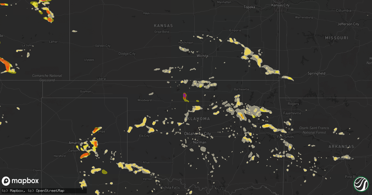
Hail Map on July 14, 2016
Get this storm
July 14 map
$229
one time, instant access
Download today. No call, no setup
Keep the $229
Bought the map and want the full workflow? Apply the entire $229 to a subscription within 7 days. None of it is wasted.
Every map, not just this one
This buys you this map. Subscription and you get every map we run, in the markets you choose from a few cities to whole states to nationwide. Plus real-time alerts the moment a storm fires.
Contact data
Name, contact info, occupancy, even credit band for addresses in the footprint. You go from where it hit to who to call.
Become the source they trust
Unlimited branding weather history reports on demand. You already have the documented answer ready for the property owner, and you are the one who showed up with it.
Property data and RoofTrace estimates
Pull up any address you have got, its value and the exact code rules for that jurisdiction, straight from One Click Code. Then RoofTrace estimates the squares, pitch, and roof value, priced the way you price.
States Impacted by Hail Map on July 14, 2016
Storm reports
Alabama
| Date | Description |
|---|---|
| 07/14/20166:18 PM CDT | Tree down along corinth road and walker road. Also trees down along county road 31 and along apricot road. Updated for additional information. |
| 07/14/20165:59 PM CDT | Tree down along corinth road. |
| 07/14/20165:55 PM CDT | Trees reported down along mountain view road. |
| 07/14/20165:55 PM CDT | Trees reported down along skyview drive. |
| 07/14/20165:51 PM CDT | A few trees reported down along hanging rock road. |
| 07/14/20165:07 PM CDT | Tree down along county road 131 in cedar bluff. Estimated 40 to 50 mph winds. Time estimated by radar. |
| 07/14/20164:58 PM CDT | Tree down along carl jones road in moody. Estimated 40 to 50 mile per hour winds. Location approximate. Time estimated by radar. |
| 07/14/20164:58 PM CDT | Tree reported down near the intersection of brook highland parkway and meadow drive. Time estimated by radar. |
| 07/14/20164:58 PM CDT | Tree and power lines down along markeeta spur road in moody. Location approximate. Estimated 40 to 50 mph winds. Time estimated by radar. |
| 07/14/20164:54 PM CDT | Tree reported down along alabama highway 25 in the dunnavant community. Time estimated by radar. |
| 07/14/20164:49 PM CDT | Tree reported down along cahaba beach drive. Location approximate. Time estimated by radar. |
| 07/14/20164:41 PM CDT | A large tree is down and blocking blue ridge blvd. |
| 07/14/20164:28 PM CDT | A very large oak tree crashed into and destroyed a home. |
| 07/14/20164:28 PM CDT | A few downed trees. |
| 07/14/20164:26 PM CDT | A few trees down in the bessemer area. |
| 07/14/20163:58 PM CDT | Two trees reported down from thunderstorm outflow winds. |
| 07/14/20163:35 PM CDT | Tree down along u.s. Highway 231 1 mile north of alabama highway 67. Estimated 40 to 50 mph winds. Time estimated by radar. |
| 07/14/20163:29 PM CDT | Tree reported down in the city of cordova. Time estimated by radar. |
| 07/14/20163:26 PM CDT | Tree down in the copeland ferry community. Location approximate. Time estimated by radar. |
| 07/14/20163:06 PM CDT | A microburst was reported... With power outages and tree limbs down across the area. |
| 07/14/20161:40 PM CDT | Power lines reported down. |
| 07/13/20169:58 PM CDT | Tree and power lines down along markeeta spur road in moody. Location approximate. Estimated 40 to 50 mph winds. Time estimated by radar. |
| 07/13/20169:58 PM CDT | Tree down along carl jones road in moody. Estimated 40 to 50 mile per hour winds. Location approximate. Time estimated by radar. |
| 07/13/20168:35 PM CDT | Tree down along u.s. Highway 231 1 mile north of alabama highway 67. Estimated 40 to 50 mph winds. Time estimated by radar. |
| 07/13/20168:29 PM CDT | Tree reported down in the city of cordova. Time estimated by radar. |
| 07/13/20168:16 PM CDT | Tree down in the copeland ferry community. Location approximate. Time estimated by radar. |
Kentucky
| Date | Description |
|---|---|
| 07/14/20165:35 PM CDT | Small tree down at us 27 and bitter sweet |
| 07/14/20165:27 PM CDT | Small trees down at decoursey pike and creektrace road |
| 07/14/20165:27 PM CDT | Photo shows one smaller tree down. Time estimated based on radar. |
| 07/14/20165:07 PM CDT | Small trees down at hands pike and crystal lake drive |
| 07/14/20165:07 PM CDT | Tree down blocking richmond road by state road 42 |
| 07/14/20165:00 PM CDT | Wires down at ockerman middle school |
| 07/14/20164:54 PM CDT | Small tree down in radcliff. Time estimated from radar. . |
| 07/14/20164:53 PM CDT | Small tree down at the corner of sparta pike and johnson road |
| 07/14/20163:28 PM CDT | Estimated 60 mph winds at the kyova mall with lamp posts knocked down in the parking lot. |
| 07/14/20163:25 PM CDT | Large tree with power lines down in roadway |
| 07/14/20163:06 PM CDT | Damage to concession stand at local drive in theater. Also several large limb down near by. |
| 07/14/20162:42 PM CDT | A tree was reported to have been blown down on us 25. |
| 07/14/20162:40 PM CDT | Received a few pictures of trees and power lines down in garrard also. Time approximated based on radar. |
| 07/14/20162:35 PM CDT | A tree was reported to have been blown down along ky 192 in the hightop vicinity. |
| 07/14/20162:26 PM CDT | Trees and power lines down in town. |
| 07/14/20162:25 PM CDT | Several trees down on hwy 1956 near colony. |
| 07/14/20162:21 PM CDT | Trees and power lines down in town. |
| 07/14/20162:10 PM CDT | Received several pics of trees and power lines down across the county. Time approximated based on radar. |
| 07/14/20161:52 PM CDT | Trees were reported to have been blown down in the science hill vicinity. |
| 07/14/201612:53 PM CDT | Tree down on durham springs road. |
| 07/14/201612:52 PM CDT | Tree down on dover church road. |
| 07/14/201612:50 PM CDT | Tree down on holland road. |
| 07/14/201612:48 PM CDT | Tree down on pope road. Some of the trees down in the county have also taken down power lines. |
| 07/14/201612:47 PM CDT | Tree down on squire lyles road. |
| 07/14/201612:47 PM CDT | Tree down on old franklin road. |
| 07/14/201612:31 PM CDT | Tree down on truck and house at 421 hendricks street. |
| 07/14/201612:31 PM CDT | Tree down on the 100 block of russell street. |
| 07/14/201612:30 PM CDT | Tree down on sunset circle. |
| 07/14/201612:22 PM CDT | Tree down at stevenson and meador. |
| 07/14/20169:34 AM CDT | Tree down across road at lonesome pine in sight of highway 815. Approximately 600 customers without power in area at height of storm. |
| 07/14/20169:05 AM CDT | A local report indicates 60 MPH wind near BEECH GROVE |
| 07/14/20168:53 AM CDT | Several trees down on hwy 1956 near colony. |
Ohio
| Date | Description |
|---|---|
| 07/14/20166:39 PM CDT | 8 trees 2-3 feet in diameter fell. House sustained roof damage. |
| 07/14/20166:12 PM CDT | Tree fell on wires. Wires down. |
Florida
| Date | Description |
|---|---|
| 07/14/20164:45 PM CDT | Trees down at government complex in ocala. Numerous trees down on the southeast side of city. |
South Carolina
| Date | Description |
|---|---|
| 07/14/20164:45 PM CDT | Town of summerville reports a tree down in the roadway on berlin myers pkwy between e carolina ave and ashely dr |
| 07/14/20162:52 PM CDT | Twitter report shows large tree split and on house on murray ave. Time estiamted from radar |
| 07/14/20162:31 PM CDT | Tree down near the intersection of sc hwy 61 and bees ferry rd |
| 07/14/20162:29 PM CDT | Multiple trees down on sc hwy 61 near magnolia plantation |
| 07/14/20162:20 PM CDT | Quarter size hail reported near the intersection of okatie hwy and snake rd. Time estimated from radar |
| 07/14/20161:27 PM CDT | Facebook report shows tree down in park west subdivision |
| 07/14/201612:54 PM CDT | Lee county dispatch reports a tree down on a car on spring hill road near bishopville sc. There were no injuries. |
| 07/14/201612:54 PM CDT | Lee county dispatch reports multiple trees down and power lines down on several roads near bishopville. Multiple trees down on light wood knot road...dogwood road and s |
| 07/14/201612:46 PM CDT | State highway patrol headquarters had two trees and multiple large limbs down on their property at 10311 wilson blvd in blythewood sc. |
| 07/14/201612:38 PM CDT | Several trees down along spring hill road near rambert church road. |
| 07/14/201611:34 AM CDT | Highway patrol reported trees down near the intersection of leesburg road and hwy. 601. . |
| 07/14/201611:30 AM CDT | Calhoun co. Dispatch reported trees down on thomas rd. At a z road. Time estimated on radar. . |
| 07/14/201611:26 AM CDT | Reported two trees down in the yard between leesburg road and hwy. 378. |
North Carolina
| Date | Description |
|---|---|
| 07/14/20166:35 PM CDT | Storm blew down a few trees on fairway knoll drive located just north of cummings cove golf and country club. |
| 07/14/20165:00 PM CDT | Strong winds blew down a sourwood tree onto a car. Time estimated by radar data. |
| 07/14/20163:10 PM CDT | Several minutes of hail varying from pea to quarter size |
| 07/14/20162:58 PM CDT | Tree and limbs down in plantation landing |
| 07/14/20162:15 PM CDT | 5-6 trees of 2-3 ft. Diameter down in downtown elkin. Several metal light poles broken and a wooden fence blown down. Power outages in town. |
| 07/14/20162:05 PM CDT | Thunderstorm wind damage resulted in a roof blown off a business within the city of elkin. Unknown original structural integrity of the business. |
| 07/14/20162:02 PM CDT | Thunderstorm winds severely damaged a garage... Downed trees... And took a roof off a barn on laurel spring church road. |
Arkansas
| Date | Description |
|---|---|
| 07/14/20166:54 PM CDT | 59 mph gust eld asos |
| 07/14/20166:50 PM CDT | Tree reported down. |
| 07/14/20166:50 PM CDT | Large tree down in smackover on vehicle |
| 07/14/20166:50 PM CDT | Trees and power lines down county wide. Out building in pine bluff destroyed by a falling tree. |
| 07/14/20166:50 PM CDT | Winds gusted to 64 mph at pine bluff grider field airport. |
| 07/14/20166:40 PM CDT | E 70 mph wind. |
| 07/14/20166:40 PM CDT | Numerous chicken houses damaged in the rison area. |
| 07/14/20166:40 PM CDT | Numerous trees were blown down in the county. |
| 07/14/20166:26 PM CDT | A local report indicates 60 MPH wind near LITTLE ROCK AIRPORT |
| 07/14/20166:20 PM CDT | Large tree and power lines down on spruce street... Also trees and powerlines down on 29 south of town |
| 07/14/20166:15 PM CDT | Trees and power lines reported down all over the county |
| 07/14/20166:15 PM CDT | Trees were blown down in sheridan and all over the county. |
| 07/14/20166:15 PM CDT | Trees and power lines reported down in hope and outside the city limits as well |
| 07/14/20166:13 PM CDT | The little rock adams field weather observer reported damage to the canopies in front of little rock airport. |
| 07/14/20166:13 PM CDT | A local report indicates 68 MPH wind near LITTLE ROCK AIRPORT |
| 07/14/20166:05 PM CDT | Three large trees were uprooted at dickey-stephens park in downtown north little rock. |
| 07/14/20166:01 PM CDT | Trees were blown down on colonel glenn road...west of i-430...with the road impassable. |
| 07/14/20166:01 PM CDT | Trees were blown down across highway 53 south...taking power lines with them. |
| 07/14/20166:00 PM CDT | Trees were blown down on markham street. |
| 07/14/20165:55 PM CDT | Some shingles were blown off of the roof of a home on rivercrest drive. |
| 07/14/20165:55 PM CDT | 50 to 60 mph gusts measured in redland community 4 miles east of prescott. Numerous large limbs and some trees snapped off |
| 07/14/20165:50 PM CDT | Trees and power lines were blown down at lawson and sparks road. |
| 07/14/20165:45 PM CDT | Trees were blown down on the campus of ouachita baptist university. |
| 07/14/20165:40 PM CDT | Power lines reported down on jacks isle road and highway 32 near millwood lake |
| 07/14/20165:25 PM CDT | Trees were blown down on brady mountain road. |
| 07/14/20165:25 PM CDT | Trees were blown down. |
| 07/14/20165:20 PM CDT | Widespread damage. At least 3 large oak trees down. Two outbuildings destroyed. |
| 07/14/20165:15 PM CDT | Trees down north and west of nashville... As well as county wide |
| 07/14/20165:10 PM CDT | Trees were blown down...and some were on houses. |
| 07/14/20165:08 PM CDT | E 60 mph winds with numerous tree limbs down. Tree down at amity / harris rd caused power outage. |
| 07/14/20165:05 PM CDT | Trees and power lines down across county but heaviest damage in horatio and locksburg area |
| 07/14/20165:01 PM CDT | Trees were blown down. |
| 07/14/20165:00 PM CDT | Trees were blown down...and some were on houses. |
| 07/14/20165:00 PM CDT | A tree was blown down on a house. |
| 07/14/20164:45 PM CDT | Several trees down in city... Strong winds estimated at 70 mph |
| 07/14/20164:43 PM CDT | A tree was snapped off near its base. |
| 07/14/20164:43 PM CDT | A local report indicates 59 MPH wind near RUSSELLVILLE |
| 07/14/20164:40 PM CDT | Trees were blown down on highway 270. |
| 07/14/20164:40 PM CDT | Significant wind damage in mt ida. Numerous trees down across town with several homes receiving damage by falling trees. Some roofs were peeled back by the wind. |
| 07/14/20164:35 PM CDT | Numerous trees and power lines were blown down between danville and dardanelle. |
| 07/14/20164:20 PM CDT | Widespread large trees down. Damage to homeowner roof. Power outages. |
| 07/14/20164:20 PM CDT | Trees and power lines were blown down over the southern half of the county. |
| 07/14/20164:20 PM CDT | Widespread large trees down. Damage to homeowner roof. Power outages. |
| 07/14/20164:15 PM CDT | Trees were downed across highway 28 near parks. |
| 07/14/20164:10 PM CDT | A portion of a deck was blown over. Numerous large limbs were down. |
| 07/14/20164:05 PM CDT | Power lines were blown down in booneville across highway 109 and grove street. The fire department was responding due to a fire in the trees. |
| 07/14/20164:05 PM CDT | Trees were blown down near waldron and in other areas of northern scott county. |
| 07/14/20164:05 PM CDT | *** 1 inj *** a tree fell on a truck...injuring one person. |
| 07/14/20164:05 PM CDT | Power lines were blown down. |
| 07/14/20163:59 PM CDT | Damage to trees was reported...and some shingles were blown off of roofs. |
| 07/14/20163:50 PM CDT | West creek road completely blocked by downed trees and power lines. Time estimated via radar. |
| 07/14/20163:50 PM CDT | Large trees were blown down. |
| 07/14/20163:42 PM CDT | Tree damage |
| 07/14/20163:40 PM CDT | 8 inch diameter pine laying across pilot grove loop off of highway 309 south. Time estimated via radar. |
| 07/14/20163:40 PM CDT | Trees down. Time estimated via radar. |
| 07/14/20163:40 PM CDT | Large tree fell on a mobile home...severely damaging it. Time estimated via radar. Photo relayed via broadcast media social media account. |
| 07/14/20163:30 PM CDT | Large trees down across wire road. Time estimated. |
| 07/14/20163:30 PM CDT | Large tree downed. Power out. Other widespread tree limb damage. Photo received via social media. Relayed by broadcast media. Time estimated. |
| 07/14/20163:17 PM CDT | Multiple large tree branches downed. Power out in town. Estimated to be at least 60 to 70 mph winds. Report relayed via social media. |
| 07/14/20163:17 PM CDT | Large tree downed. Photo received via social media. |
| 07/14/20163:15 PM CDT | Significant roof damage to a log home business. Time estimated via radar. Photo relayed via broadcast media social media account. |
| 07/14/20163:05 PM CDT | Power poles snapped. Relayed via social media. |
| 07/14/20163:00 PM CDT | Tree down |
| 07/13/20167:55 PM CDT | Trees and powerlines downed all through the city. |
| 07/13/20167:45 PM CDT | Trees were downed due to strong straight line winds. |
| 07/13/20167:35 PM CDT | Large tree snapped on timberlane at the old high... West side of el dorado |
| 07/13/20167:28 PM CDT | The roof was blown off of three businesses in town. |
| 07/13/20167:25 PM CDT | Trees and signs were blown down. |
| 07/13/20167:15 PM CDT | A tree fell on a house. |
| 07/13/20167:10 PM CDT | Several trees down in town. One building on the square lost half the roof. Power lines down. |
| 07/13/20167:05 PM CDT | Trees were blown down. |
| 07/13/20167:00 PM CDT | Trees and power lines reported down county wide |
New Hampshire
| Date | Description |
|---|---|
| 07/14/20165:00 PM CDT | Tree down near the airport |
| 07/14/20164:45 PM CDT | Branches and power lines down causing power outages |
| 07/14/20164:45 PM CDT | Branches and power lines down causing power outages |
| 07/14/20164:20 PM CDT | Numerous trees and wires down |
| 07/14/20164:15 PM CDT | Multiple trees and wires down |
| 07/14/20164:05 PM CDT | Multiple trees and wires down |
Georgia
| Date | Description |
|---|---|
| 07/14/20163:05 PM CDT | Camden county 911/dispatch reports a tree downed by strong thunderstorm winds across north camden street in kingsland. Time of damage based on radar data. |
| 07/14/20162:15 PM CDT | Chatham co em reports a tree down on power line in the 8500 block of lyn ave. Also nearby a tree fell on power lines near the intersection of coffee bluff rd and vernon |
| 07/14/201612:08 PM CDT | Liberty co warning point reports a tree down across mary todd rd near the intersection of ray rd. Time estimated from radar |
Mississippi
| Date | Description |
|---|---|
| 07/13/201610:12 PM CDT | Utility pole broken along dry grove rd |
| 07/13/20169:40 PM CDT | Tree down on house on savanna st. Powerlines down in same area. Radar estimated time. |
| 07/13/20169:35 PM CDT | Utility poles broken along i-55 and elton rd |
| 07/13/20169:35 PM CDT | Trees and powerlines downed throughout the city and county. Numerous trees were downed on i-20 near vicksburg. |
| 07/13/20169:30 PM CDT | Scattered trees and power lines down in the county. |
| 07/13/20169:25 PM CDT | Powerlines snapped on springridge rd in clinton. |
| 07/13/20169:25 PM CDT | Trees downed at the intersection of hwy 16 and hwy 17. Tree fell on a powerline at this location. A tree also fell on the natchez trace nearby. |
| 07/13/20169:23 PM CDT | Utility pole broken off westhaven dr |
| 07/13/20169:10 PM CDT | Trees downed on clinton-raymond road. |
| 07/13/20169:01 PM CDT | Tree downed onto utility equipment off st thomas rd |
| 07/13/20168:59 PM CDT | Utility pole broken off northside dr |
| 07/13/20168:55 PM CDT | Tree downed onto utility equipment |
| 07/13/20168:55 PM CDT | A few trees and power lines downed along valley rd |
| 07/13/20168:45 PM CDT | Trees and power lines around the intersection of luther ray cobb rd and raymond cobb rd |
| 07/13/20168:45 PM CDT | Trees were down across the county. |
| 07/13/20168:40 PM CDT | Tree downed across grant road. |
| 07/13/20168:30 PM CDT | Numerous trees downed across the southern parts of the county...mainly south of highway 438. |
| 07/13/20168:25 PM CDT | Trees were down across the county. |
| 07/13/20168:22 PM CDT | Big tree down near longwood dr. Fence and several large limbs blown down on turnberry cove in the same neighborhood. |
| 07/13/20168:01 PM CDT | Tree downed onto utility equipment off st thomas rd |
| 07/13/20167:59 PM CDT | Utility pole broken off northside dr |
| 07/13/20167:15 PM CDT | Tree down across sandyland rd. |
Indiana
| Date | Description |
|---|---|
| 07/14/20164:53 PM CDT | Large tree blocking atkinson hill road near markland pike |
| 07/14/20163:30 PM CDT | Trees snapped and uprooted. |
| 07/14/20163:30 PM CDT | A local report indicates 60 MPH wind near SANTA CLAUS |
South Dakota
| Date | Description |
|---|---|
| 07/14/20163:25 AM CDT | Time estimated based on radar |
| 07/13/201610:30 PM CDT | A local report indicates 67 MPH wind near 2 SW BRIDGER |
| 07/13/201610:20 PM CDT | Many broken branches |
| 07/13/201610:20 PM CDT | Many broken branches |
| 07/13/201610:15 PM CDT | A local report indicates 60 MPH wind near 6 N HOWES |
| 07/13/201610:00 PM CDT | A local report indicates 1.00 inch wind near 10 NNW HOWES |
| 07/13/20169:54 PM CDT | A local report indicates 1.25 inch wind near 13 SSW FAITH |
| 07/13/20169:44 PM CDT | A local report indicates 1.00 inch wind near 10 WSW FAITH |
| 07/13/20169:22 PM CDT | A local report indicates 1.75 inch wind near 17 SW USTA |
| 07/13/20169:10 PM CDT | A local report indicates 2.00 inch wind near 17 WSW USTA |
| 07/13/20169:00 PM CDT | A local report indicates 58 MPH wind near 7 SSE MEADOW |
| 07/13/20168:55 PM CDT | A local report indicates 1.00 inch wind near 3 SSE DATE |
| 07/13/20168:20 PM CDT | A local report indicates 1.50 inch wind near 7 E REVA |
| 07/13/20168:20 PM CDT | A local report indicates 1.75 inch wind near 3 E REVA |
| 07/13/20168:10 PM CDT | Hail was still falling at 0715 pm |
| 07/13/20167:50 PM CDT | A local report indicates 1.00 inch wind near 1 N LODGEPOLE |
| 07/13/20167:40 PM CDT | A local report indicates 1.75 inch wind near 1 S LUDLOW |
West Virginia
| Date | Description |
|---|---|
| 07/14/20164:38 PM CDT | Branches down along route 85 between madison and danville. |
| 07/14/20164:37 PM CDT | One tree down on creek road in danville. |
| 07/14/20163:03 PM CDT | Trees reported down near log gardens |
| 07/14/20163:00 PM CDT | Trees down on winfield road near the kanawha-putnam county line. |
| 07/14/20162:42 PM CDT | Multiple branches down and a few power outages in the town of clay. |
Pennsylvania
| Date | Description |
|---|---|
| 07/14/20166:40 PM CDT | Trees down |
| 07/14/20166:30 PM CDT | 8 to 10 power poles down. |
| 07/14/20161:44 PM CDT | Numerous trees and wires down. |
| 07/13/20168:40 PM CDT | Trees down |
| 07/13/20168:10 PM CDT | Tree down on albany road. Time estimated by radar. |
| 07/13/20168:10 PM CDT | Trees down |
| 07/13/20168:05 PM CDT | Two utility poles and wires down. |
| 07/13/20167:10 PM CDT | Tree down |
| 07/13/20167:00 PM CDT | Tree down |
Oklahoma
| Date | Description |
|---|---|
| 07/14/20163:55 PM CDT | Numerous trees down on beachton road east side of smithville |
| 07/14/20163:40 PM CDT | Minor wind damage to a barn and chicken house in the haw creek area. Time estimated. |
| 07/14/20163:15 PM CDT | Powerlines down along williams road. |
| 07/14/20163:09 PM CDT | Trees and powerlines down near intersection of highway 271 and cutoff road just north of talihina. Relayed by emergency management. |
| 07/14/20163:03 PM CDT | Tree down |
| 07/14/20162:55 PM CDT | A local report indicates 58 MPH wind near 4 SE TALIHINA |
| 07/14/20162:45 PM CDT | Large tree limbs were snapped |
| 07/14/20162:40 PM CDT | Trees and power lines were blown down |
| 07/14/20162:35 PM CDT | At least 60 mph winds estimated in hartshorne. Relayed by le flore county emergency management. |
| 07/14/20162:30 PM CDT | Trees and power lines were blown down west of town |
| 07/14/20162:30 PM CDT | Mesonet station measured 58 mph thunderstorm wind gusts |
| 07/14/20162:26 PM CDT | Trees were blown down |
| 07/14/20162:23 PM CDT | Roof off business. Relayed via social media. |
| 07/14/20162:20 PM CDT | Estimated by a spotter. Relayed by media. |
| 07/14/20162:15 PM CDT | Large tree downed. Photo received via social media. Time estimated via radar. |
| 07/14/20162:15 PM CDT | Measured at the tahlequah municipal airport. |
| 07/14/20162:05 PM CDT | Estimated 60 mph thunderstorm wind gusts |
| 07/14/20161:59 PM CDT | Tree down on car |
| 07/14/20161:57 PM CDT | Tree down on house |
| 07/14/20161:50 PM CDT | A local report indicates 70 MPH wind near TAHLEQUAH |
| 07/14/20161:46 PM CDT | Power lines down...tree damage...roof damage. Reports received via social media. Time estimated. |
| 07/14/20161:46 PM CDT | A local report indicates 72 MPH wind near EUFAULA |
| 07/14/20161:43 PM CDT | Tree limbs and branches down in henryetta. |
| 07/14/20161:34 PM CDT | Roof blown off building west of maize on us-69. |
| 07/14/20161:30 PM CDT | Roof damage to buildings at glenpool middle school. Time estimated via radar. |
| 07/14/20161:30 PM CDT | Numerous trees were blown down and buildings were damaged at the park. Campgrounds around fort gibson lake had considerable tree damage. |
| 07/14/20161:30 PM CDT | Tractor trailer blown over |
| 07/14/20161:28 PM CDT | Tree damage in glenpool. |
| 07/14/20161:21 PM CDT | Trees blown down south of chouteau |
| 07/14/20161:20 PM CDT | A local report indicates 80 MPH wind near HASKELL |
| 07/14/20161:20 PM CDT | Trees were blown down at muskogee country club |
| 07/14/20161:20 PM CDT | Mesonet station near porter measured 68 mph thunderstorm wind gusts |
| 07/14/20161:15 PM CDT | Storm spotters measured 90 mph thunderstorm wind gusts |
| 07/14/20161:15 PM CDT | One mobile home destroyed and others blown off their foundations. Relayed by rogers county emergency management. Time estimated. |
| 07/14/20161:13 PM CDT | Power poles downed in wagoner. Photos received via social media. Time estimated. |
| 07/14/20161:12 PM CDT | Mobile home rolled |
| 07/14/20161:10 PM CDT | Fox 23 stormtracker report at us-69. |
| 07/14/20161:10 PM CDT | A local report indicates 65 MPH wind near MAZIE |
| 07/14/20161:10 PM CDT | Significant wind damage at a shopping center in muskogee. Numerous photos seen on social media and on television. Time estimated via radar. |
| 07/14/20161:08 PM CDT | Strong thunderstorm wind damaged roofs of buildings...blew down power lines...snapped large tree limbs...and blew down tents that were setup for the porter peach festiv |
| 07/14/20161:00 PM CDT | Strong thunderstorm wind damaged the roof of the coweta school...damaged buildings...blew down power lines...and snapped large tree limbs. |
| 07/14/201612:58 PM CDT | Several roofs off barns. Few barns and out buildings destroyed. Winds estimated around 100 mph. |
| 07/14/201612:50 PM CDT | A local report indicates 58 MPH wind near BIXBY |
| 07/14/201612:45 PM CDT | Oklahoma mesonet station measured 60 mph thunderstorm wind gusts |
| 07/14/201612:45 PM CDT | Significant tree damage on highway 64 |
| 07/14/201612:45 PM CDT | Tree... Shingle... Fence damage. Tranpoline flipped. Near 91st and lynn |
| 07/14/201612:40 PM CDT | Snapped tree and lots of small branches down. |
| 07/14/201612:40 PM CDT | Large tree limbs were snapped |
| 07/14/201612:40 PM CDT | 1.5 inch hail near 151st street and yale. |
| 07/14/201612:40 PM CDT | Tree snapped. Relayed by off duty nws employee. Time estimated by radar. |
| 07/14/201612:40 PM CDT | Tree branches and roofing material blown around near 151st and yale. |
| 07/14/201612:40 PM CDT | A local report indicates 66 MPH wind near 4 W HECTORVILLE |
| 07/14/201612:38 PM CDT | Small trees snapped on the se side of tulsa. |
| 07/14/201612:36 PM CDT | Large tree limb broken at baptist village in owasso. Time estimated from radar. |
| 07/14/201612:35 PM CDT | Power lines and multiple tree limbs down near memorial and 71st street. |
| 07/14/201612:30 PM CDT | Large tree limbs were blown down |
| 07/14/201612:30 PM CDT | Tree down blocking riverside dr. At 91st via social media. Time estimated from radar. |
| 07/14/201612:28 PM CDT | Strong thunderstorm wind blew much of the roof off a home |
| 07/14/201612:22 PM CDT | Roof damage to large barn angus valley in sand springs. Via social media. Time estimated from radar. |
| 07/14/201612:15 PM CDT | Significant wind damage to trees including at least one laying on a house. Photos received via social media and additional reports from broadcast media. Time estimated. |
| 07/14/201612:15 PM CDT | Trees were snapped or uprooted |
| 07/14/201612:04 PM CDT | Numerous trees down. Time estimated from radar. |
| 07/14/201612:00 PM CDT | Trees were blown down |
| 07/14/201611:48 AM CDT | Lots of tree branches and one large tree down in cleveland. |
| 07/14/201611:27 AM CDT | Tree blown down |
| 07/14/201611:00 AM CDT | A local report indicates 58 MPH wind near 2 NW PONCA CITY |
| 07/14/201610:59 AM CDT | Kfor storm chaser |
| 07/14/201610:52 AM CDT | A local report indicates 58 MPH wind near 2 NW PONCA CITY |
| 07/14/201610:42 AM CDT | Estimated 60 to 70 mph gust. |
| 07/14/201610:41 AM CDT | Estimated 60 to 70 mph. |
| 07/14/201610:28 AM CDT | Dime to quarter hail. |
| 07/14/201610:28 AM CDT | A local report indicates 60 MPH wind near 5 W BLACKWELL |
| 07/14/20162:55 AM CDT | A local report indicates 58 MPH wind near 3 NNW SHAWNEE |
| 07/14/20161:23 AM CDT | Near intersection of highway 18 and highway 51. |
| 07/14/20161:15 AM CDT | A local report indicates 59 MPH wind near 2 SSW MINCO |
| 07/14/20161:10 AM CDT | A local report indicates 59 MPH wind near 2 SSW MINCO |
| 07/14/20161:00 AM CDT | A local report indicates 65 MPH wind near 2 SSW MINCO |
| 07/14/201612:55 AM CDT | A local report indicates 62 MPH wind near 2 SSW MINCO |
| 07/14/201612:50 AM CDT | A local report indicates 70 MPH wind near 2 SSW MINCO |
| 07/14/201612:48 AM CDT | A local report indicates 75 MPH wind near UNION CITY |
| 07/14/201612:46 AM CDT | Near intersection of se 45th and highway 7. |
| 07/14/201612:30 AM CDT | A local report indicates 60 MPH wind near 3 W MEDICINE PARK |
| 07/14/201612:25 AM CDT | A local report indicates 60 MPH wind near 4 NNW FORT COBB |
| 07/14/201612:20 AM CDT | A local report indicates 60 MPH wind near 3 W MEDICINE PARK |
| 07/14/201612:10 AM CDT | A local report indicates 58 MPH wind near 5 S ELK CITY |
| 07/14/201612:00 AM CDT | A local report indicates 60 MPH wind near SSE CARNEGIE |
| 07/13/201610:20 PM CDT | A local report indicates 1.25 inch wind near 12 W OKARCHE |
Vermont
| Date | Description |
|---|---|
| 07/14/20163:50 PM CDT | Trees down |
| 07/14/20163:48 PM CDT | Trees down |
| 07/14/20163:18 PM CDT | Trees down...power lines down...sparking fire on power line. |
| 07/14/20163:05 PM CDT | Numerous trees down |
North Dakota
| Date | Description |
|---|---|
| 07/14/20166:50 PM CDT | . |
| 07/14/20166:45 PM CDT | Hail bigger than ping pong balls. |
| 07/14/20166:26 PM CDT | Some quarters... Hail covering the ground. |
| 07/14/20166:18 PM CDT | Nickel to quarter size hail gave way to pea to dime size hail. Ground is covered. Corrected to notate estimated size instead of unknown. . |
Colorado
| Date | Description |
|---|---|
| 07/14/20166:56 PM CDT | . |
| 07/14/20166:55 PM CDT | Golfball size hail report at mile marker 393 on i-70. |
| 07/14/20166:52 PM CDT | Passed to em by law enforcement. Time estimated by radar. |
| 07/14/20166:50 PM CDT | . |
| 07/14/20166:30 PM CDT | . |
| 07/14/20166:15 PM CDT | . |
| 07/14/20166:10 PM CDT | . |
| 07/14/20166:03 PM CDT | . |
| 07/14/20165:56 PM CDT | . |
| 07/14/20165:55 PM CDT | . |
| 07/14/20165:55 PM CDT | . |
| 07/14/20165:07 PM CDT | . |
| 07/14/20164:28 PM CDT | Pea to golfball size hail. Ended at time of event. |
| 07/14/20164:06 PM CDT | Observed by the contract observer at the airport. |
| 07/14/20163:55 PM CDT | . |
| 07/14/20163:50 PM CDT | . |
| 07/14/20163:46 PM CDT | Report taken along interstate 25. |
| 07/13/20168:35 PM CDT | Relayed via twitter from denver7 |
| 07/13/20167:38 PM CDT | Time estimated by radar. Hail covered ground. |
| 07/13/20167:30 PM CDT | A local report indicates 1.75 inch wind near 8 SE ELBERT |
| 07/13/20167:28 PM CDT | . |
| 07/13/20167:26 PM CDT | Observer had a window broken by the hail. |
| 07/13/20167:23 PM CDT | Report given to em by law enforcement. Time estimated by radar. |
| 07/13/20167:20 PM CDT | Quarter to golf ball size hail. |
| 07/13/20167:11 PM CDT | On i70 between mile markers 405 and 410. |
| 07/13/20167:10 PM CDT | Time estimated by radar. |
Missouri
| Date | Description |
|---|---|
| 07/14/20166:12 PM CDT | Hail from one half to three quarter inch along with small tree limbs down. |
| 07/14/201611:29 AM CDT | Severe thunderstorm wind gusts downed a large limb near centergas fuels. |
| 07/14/201610:55 AM CDT | Large tree snapped along highway 171 |
Kansas
| Date | Description |
|---|---|
| 07/14/20163:29 PM CDT | A local report indicates 1.00 inch wind near 4 SSW SABETHA |
| 07/14/201610:45 AM CDT | A local report indicates 1.00 inch wind near CRESTLINE |
| 07/14/20168:56 AM CDT | Estimated between 60 and 70 mph. |
| 07/14/20168:52 AM CDT | At the augusta airport. |
| 07/14/20168:46 AM CDT | Numerous poles down reported by emergency management |
| 07/14/20168:44 AM CDT | Poles down near illinois and zoo blvd. |
| 07/14/20168:41 AM CDT | Estimated between 60 and 70 mph. |
| 07/14/20168:39 AM CDT | A local report indicates 64 MPH wind near JABARA AIRPORT |
| 07/14/20168:36 AM CDT | A local report indicates 70 MPH wind near 2 NNE WICHITA EISENHOWE |
| 07/14/20168:22 AM CDT | Three inch tree limb down. |
| 07/14/20168:17 AM CDT | Tent blown into power lines. |
| 07/14/20168:17 AM CDT | A local report indicates 80 MPH wind near WICHITA EISENHOWER NATL |
| 07/14/20168:15 AM CDT | A local report indicates 60 MPH wind near 3 WNW PARK CITY |
| 07/14/20168:14 AM CDT | A local report indicates 75 MPH wind near 2 WNW WICHITA EISENHOWE |
| 07/14/20167:55 AM CDT | Large tree limb was blown out of a tree. Report is delayed and via social media. |
| 07/14/20167:32 AM CDT | Two power poles were down. |
| 07/14/20167:01 AM CDT | A local report indicates 60 MPH wind near 1 W ARLINGTON |
Illinois
| Date | Description |
|---|---|
| 07/14/20166:58 PM CDT | A local report indicates 58 MPH wind near SCOTT AFB |
| 07/14/20166:25 PM CDT | Wind gusts estimated at 40 to 45 mph blew some highway constructions signs over on i-255. |
Texas
| Date | Description |
|---|---|
| 07/14/20166:50 PM CDT | A local report indicates 1.75 inch wind near SKELLYTOWN |
| 07/14/20166:40 PM CDT | 13 large transmission poles blown down 1 mile north of intersection of fm 179 and us 380 |
| 07/14/20165:24 PM CDT | Straight line wind damage to several buildings. Flipped camper or trailer destroyed. |
| 07/13/20168:36 PM CDT | A local report indicates 1.25 inch wind near 1 NNW LAKE TANGLEWOOD |
| 07/13/20168:26 PM CDT | Reported by west texas mesonet station |
| 07/13/20168:05 PM CDT | A local report indicates 58 MPH wind near 2 E ANDREWS |
| 07/13/20168:00 PM CDT | Wind gust reported by west texas mesonet site 10 wsw guthrie |
| 07/13/20168:00 PM CDT | A local report indicates 1.00 inch wind near GOODNIGHT |
| 07/13/20167:45 PM CDT | Reported by west texas mesonet station |
| 07/13/20167:43 PM CDT | A local report indicates 1.75 inch wind near 3 NNE WAYSIDE |
| 07/13/20167:37 PM CDT | A local report indicates 61 MPH wind near 2 WNW TARZAN |
| 07/13/20167:35 PM CDT | A local report indicates 60 MPH wind near 8 W GROOM |
| 07/13/20167:35 PM CDT | A local report indicates 1.00 inch wind near 8 W GROOM |
| 07/13/20167:31 PM CDT | A local report indicates 1.00 inch wind near 1 W GROOM |
| 07/13/20167:29 PM CDT | A local report indicates 60 MPH wind near 4 W GROOM |
| 07/13/20167:25 PM CDT | A local report indicates 1.75 inch wind near 1 W GROOM |
| 07/13/20167:24 PM CDT | A local report indicates 1.75 inch wind near 3 NNE WAYSIDE |
Nebraska
| Date | Description |
|---|---|
| 07/14/20166:52 AM CDT | A local report indicates 1.00 inch wind near BROKEN BOW |
| 07/14/20164:30 AM CDT | Hail ranged from pea to golf ball size. Time estimated from radar |
Louisiana
| Date | Description |
|---|---|
| 07/13/20169:55 PM CDT | Tree downed across a road in harrisonburg |
| 07/13/20169:25 PM CDT | Two trees downed on highway 875 in wisner. |
| 07/13/20169:10 PM CDT | Tree down 1 north of olla |
| 07/13/20169:05 PM CDT | Tree downed on powerline on moss road. |
| 07/13/20169:00 PM CDT | Trees and power lines down across the parish. |
| 07/13/20169:00 PM CDT | Tree downed at pill green road near hwy 577. One tree fell on powerline on hwy 577. |
| 07/13/20168:40 PM CDT | Trees and powerlines downed throughout the parish. |
| 07/13/20168:38 PM CDT | Trees and power lines reported down all over the parish |
| 07/13/20168:30 PM CDT | Trees and powerlines downed all throughout the parish... Inlcuding on roadways hwy 589... Hwy 585... Bienz rd... And pull tight rd. Several sheds toppled/damaged throug |
| 07/13/20168:30 PM CDT | Trees and power lines down across the parish. |
| 07/13/20168:25 PM CDT | Trees downed all throughout the parish. |
| 07/13/20168:20 PM CDT | Trees reported down parish wide...and several power lines brought down by fallen trees |
| 07/13/20168:10 PM CDT | Power out due to transformers reported damaged due to storms |
| 07/13/20168:10 PM CDT | Large tree uprooted whites ferry rd in west monroe |
| 07/13/20168:05 PM CDT | Trees downed all through the northern portions of the parish. |
| 07/13/20168:00 PM CDT | 20 trees down across the parish |
| 07/13/20167:50 PM CDT | Roof blown off car wash in marion |
| 07/13/20167:45 PM CDT | Tree across road near farmerville observer |
| 07/13/20167:40 PM CDT | Trees reported down all over the northern part of the parish |
| 07/13/20167:30 PM CDT | Trees reported down all over the parish |
| 07/13/20167:25 PM CDT | 15 trees down mainly near hwy 79 as well as power lines down started fires on alt 2 and oil center road in haynesville... And another fire on stand pipe and camp road |
| 07/13/20167:10 PM CDT | Numerous trees down and transformer damage reported in northern part of the parish |
Maine
| Date | Description |
|---|---|
| 07/14/20166:20 PM CDT | Tree down on mcburnie road reported by presque isle pd. |
| 07/14/20166:00 PM CDT | 85 to 90 trees snapped or uprooted over a 300 by 300 foot area |
| 07/14/20165:25 PM CDT | Trees down on power lines on tangle ridge road. Time estimated from radar. |
| 07/14/20165:05 PM CDT | Trees down on school street. Time estimated from radar. |
| 07/14/20165:00 PM CDT | Trees down on lake road and on us 1. |
| 07/14/20164:30 PM CDT | Trees down in multiple spots on red river road. Time estimated from radar. |
| 07/14/20164:20 PM CDT | One large tree uprooted and one large tree snapped in st david cemetery |
| 07/14/20164:20 PM CDT | Large storage shed flattened and vegetable stand picked up and turned over. |
| 07/14/20164:20 PM CDT | Large storage shed flattened and vegetable stand picked up and turned over. |
| 07/14/20164:19 PM CDT | Several trees down on gagnon road |
| 07/14/20164:05 PM CDT | Trees down in multiple spots on red river road. Time estimated from radar. |
| 07/14/20164:00 PM CDT | Trees down on cline road. Time is estimated. |
Tennessee
| Date | Description |
|---|---|
| 07/14/20166:05 PM CDT | A tree down near tusculum. |
| 07/14/20165:54 PM CDT | One tree down in greeneville |
| 07/14/20164:04 PM CDT | Multiple trees reported down across the county |
| 07/14/20164:00 PM CDT | Multiple large limbs down along edgewood avenue with estimated winds of 60 mph. |
| 07/14/20163:56 PM CDT | Tree down on a home via social media. |
| 07/14/20163:45 PM CDT | A couple of tree reported down in monroe county |
| 07/14/20163:40 PM CDT | A local report indicates 1.50 inch wind near 4 NE FARRAGUT |
| 07/14/20163:40 PM CDT | Tree on car |
| 07/14/20163:31 PM CDT | A couple of large limbs down. |
| 07/14/20163:30 PM CDT | Multiple trees down across southern portions of the county |
| 07/14/20163:26 PM CDT | A local report indicates 1.00 inch wind near FARRAGUT |
| 07/14/20163:15 PM CDT | A few trees down across the county from 4 to 420pm |
| 07/14/20162:00 PM CDT | Part of tree down on doak road in manchester. Time estimated based on radar. |
| 07/14/20162:00 PM CDT | One inch hail near 109 just south of i-40 |
| 07/14/20161:52 PM CDT | Corrected location and time. Tspotter twitter photo showed tree down on house on hartsville pike. Time estimated based on radar. |
| 07/14/20161:38 PM CDT | Tspotter twitter photo showed tree down on house on hartsville pike. Time estimated based on radar. |
| 07/14/201612:17 PM CDT | A picture of a fallen tree was posted to office facebook page. |
| 07/14/201612:15 PM CDT | A tree down reported in orlinda. |
| 07/14/201611:42 AM CDT | Tree reported down on carter road. |
| 07/14/201611:40 AM CDT | Fire chief reports at least 3 trees down on hwy 224. |
| 07/14/201611:30 AM CDT | A tree was reported down on oak road. |
| 07/14/201611:30 AM CDT | A tree was reported down on pinewood road. |
| 07/14/201611:30 AM CDT | A tree down reported in adams. |
| 07/14/201611:30 AM CDT | A tree was reported down on hwy 48 north. |
| 07/14/201610:45 AM CDT | One tree reported down on weaks cemetary road and freeman fielders road. The tree is blocking the road. |
Montana
| Date | Description |
|---|---|
| 07/14/20165:00 PM CDT | Quarter sized hail reported by the public through social media. |
| 07/14/20164:47 PM CDT | A local report indicates 1.00 inch wind near 3 SE GLENDIVE |
| 07/14/20164:45 PM CDT | A local report indicates 1.50 inch wind near GLENDIVE |
| 07/14/20164:45 PM CDT | A local report indicates 1.25 inch wind near 2 W GLENDIVE |
| 07/14/20164:38 PM CDT | Quarter sized hail reported with photo from the general public via social media |
| 07/14/20164:35 PM CDT | A local report indicates 1.00 inch wind near 1 W GLENDIVE |
Massachusetts
| Date | Description |
|---|---|
| 07/14/20165:48 PM CDT | Tree down at the intersection of burlingame and warregan street...blocking burlingame |
| 07/14/20165:45 PM CDT | Tree and wires down on anderson avenue |
| 07/14/20165:40 PM CDT | Wires down on south street...400 block |
| 07/14/20165:30 PM CDT | Large tree down on wires on turners falls road |
Virginia
| Date | Description |
|---|---|
| 07/14/20166:44 PM CDT | Pair of trees into houses and one tree blocking roadway near 186 ashby ct |
| 07/14/20163:56 PM CDT | Tree down |
| 07/14/20163:47 PM CDT | Trees down |
| 07/14/20163:11 PM CDT | Tree down |
| 07/14/20163:10 PM CDT | Thunderstorm winds brought down trees along route 57 in patrick county... Va |
| 07/14/20163:08 PM CDT | Thunderstorm winds brought down numerous trees across the community of critz in patrick county... Va. |
| 07/14/20163:06 PM CDT | Thunderstorm winds brought down at least two trees across 58 bypass on the ne side of martinsville. |
| 07/14/20163:00 PM CDT | Thunderstorm winds brought down at least two trees along route 58 on the north side of stuart... Va. |
| 07/14/20162:51 PM CDT | 2 trees down |
| 07/14/20162:44 PM CDT | Trees and power lines down |
| 07/14/20162:34 PM CDT | Thunderstorm winds brought down several trees in and around woolwine temporarily closing roadways. |
| 07/14/20162:27 PM CDT | Large tree limbs down |
| 07/14/20162:22 PM CDT | Thunderstorm winds caused numerous trees down across the community of union hall in franklin county... Va. |
| 07/14/20162:19 PM CDT | Trees and power lines down |
| 07/14/20161:10 PM CDT | Tree down on zion hill road |
| 07/14/20161:05 PM CDT | Tree down |
New York
| Date | Description |
|---|---|
| 07/14/20163:40 PM CDT | Trees and tree branches down with power lines at intersection of upland avenue and woodcrest |
| 07/14/20163:40 PM CDT | Multiple reports of power lines down more than 5000 power outages reported |
| 07/14/20163:37 PM CDT | 147th avenue closed between 232nd street and 235th street due to trees down on top of primary wires |
| 07/14/20163:05 PM CDT | Downed tree on i-87 southbound blocking two lanes |
| 07/14/20161:54 PM CDT | Trees down in moriah and port henry |
| 07/14/20161:00 PM CDT | Localized area of numerous uprooted trees. Some snapped. Radar estimated time. |
| 07/14/201612:12 PM CDT | Large tree uprooted crushing car |
| 07/13/20168:37 PM CDT | 6 trees down in westmoreland... Trees and wires down verona and utica |
New Jersey
| Date | Description |
|---|---|
| 07/14/20163:08 PM CDT | 2 people injured by falling tree in rahway river park |
| 07/14/20162:58 PM CDT | Tree fell on a car at branchbrook drive |
| 07/14/20162:49 PM CDT | Large tree snapped and fell on fence |
| 07/14/20162:48 PM CDT | Tree down at intersection of woodland and randolph avenue |
| 07/14/20162:46 PM CDT | Large tree snapped and down on a car at maple street |
| 07/14/20162:46 PM CDT | Tree down on a house on mohawk drive |
| 07/14/20162:46 PM CDT | Tree fell on power line and house with some structural damage on berkeley place |
| 07/14/20162:45 PM CDT | Tree down blocking north avenue |
| 07/14/20162:38 PM CDT | Downed and uprooted trees on woodland ave |
| 07/14/20162:30 PM CDT | Numerous trees down |
| 07/14/20161:55 PM CDT | Several large limbs blown down onto vehicle. Time estimated from radar. |
| 07/14/20161:48 PM CDT | Several buildings damaged. |
| 07/14/20161:48 PM CDT | A barn was destroyed along with wires and poles down on route 519. |
| 07/14/20161:40 PM CDT | Several buildings damaged. |
Cities Impacted by Hail Map on July 14, 2016
- Eldorado, OK
- Gould, OK
- Bowman, ND
- Pueblo, CO
- Kingfisher, OK
- Claude, TX
- Mer Rouge, LA
- Sand Springs, OK
- Cleveland, OK
- Mannford, OK
- Terlton, OK
- Cody, NE
- Pine Ridge, SD
- Manderson, SD
- Lakeside, NE
- Alliance, NE
- Ellsworth, NE
- Hamilton, KS
- Kyle, SD
- Scenic, SD
- Custer City, OK
- Murfreesboro, AR
- Childress, TX
- Quanah, TX
- Mentone, TX
- Floydada, TX
- Petersburg, TX
- Lockney, TX
- Tahlequah, OK
- Preston, MS
- Midland, TX
- Hammon, OK
- Leedey, OK
- Cheyenne, OK
- Kit Carson, CO
- Hastings, FL
- East Palatka, FL
- San Mateo, FL
- Blackwell, OK
- Braman, OK
- Nardin, OK
- Pocasset, OK
- Chickasha, OK
- Gordo, AL
- Carrollton, AL
- Jessieville, AR
- Taloga, OK
- Hendersonville, TN
- Amory, MS
- Aberdeen, MS
- Reva, SD
- Belleville, IL
- Model, CO
- Prairie City, SD
- Madison, KS
- Batesland, SD
- Valentine, NE
- Kilgore, NE
- Wanblee, SD
- Martin, SD
- Merriman, NE
- Tuthill, SD
- Porcupine, SD
- Nenzel, NE
- Thedford, NE
- Allen, SD
- Johnstown, NE
- Hodgen, OK
- Alpine, AL
- Talladega, AL
- Gladstone, NM
- Faith, SD
- Eufaula, OK
- Heavener, OK
- Groom, TX
- Oshkosh, NE
- Bingham, NE
- Hyannis, NE
- Ashby, NE
- Pleasant View, TN
- Ashland City, TN
- Seibert, CO
- Flagler, CO
- Stratton, CO
- Vona, CO
- Erie, KS
- Galesburg, KS
- Parsons, KS
- Patriot, IN
- Rising Sun, IN
- Kermit, TX
- Caneyville, KY
- Weleetka, OK
- Henryetta, OK
- Dickens, TX
- Maize, KS
- Robards, KY
- Circle, MT
- Haven, KS
- Inola, OK
- Bristow, IN
- Saint Meinrad, IN
- Seagraves, TX
- Broken Bow, OK
- Wagoner, OK
- Porter, OK
- Coweta, OK
- Nocona, TX
- Waldron, AR
- Farragut, TN
- Knoxville, TN
- Franklin, LA
- Millington, TN
- Arlington, TN
- Memphis, TN
- Brownfield, TX
- Lemmon, SD
- Meadow, SD
- Mansfield, AR
- Huntington, AR
- Yale, OK
- Hayes Center, NE
- Colorado Springs, CO
- Cedar Hill, TN
- Hamilton, MS
- Brewster, NE
- Anselmo, NE
- Erin, TN
- Waverly, TN
- Osage, OK
- Prue, OK
- Wilburton, OK
- Hartshorne, OK
- Groton, VT
- Sun City, KS
- Wilmore, KS
- Greeneville, TN
- Fountain, CO
- Fairview, KS
- Seneca, KS
- Vermillion, KS
- Oneida, KS
- Corning, KS
- Frankfort, KS
- Goff, KS
- Sabetha, KS
- Centralia, KS
- Arthur, NE
- Castle, OK
- Okemah, OK
- Bixby, OK
- Weston, CO
- Huntington, WV
- South Point, OH
- Okarche, OK
- Caddo Gap, AR
- Glendive, MT
- Diamond, MO
- Carthage, MO
- Sarcoxie, MO
- Hydro, OK
- Paoli, OK
- Pauls Valley, OK
- Scottsville, KY
- Duncan, OK
- Rhame, ND
- Colwich, KS
- Sharon, KS
- Haigler, NE
- Wray, CO
- Snyder, TX
- Oakwood, OK
- Canton, OK
- Watonga, OK
- Peyton, CO
- Elbert, CO
- Hampstead, NC
- Wilmington, NC
- Covington, OK
- Lucien, OK
- Marshall, OK
- Perry, OK
- Orlando, OK
- Levelland, TX
- Ropesville, TX
- Lubbock, TX
- Smyer, TX
- Catoosa, OK
- Scranton, ND
- Gallatin, TN
- Lebanon, TN
- Castalian Springs, TN
- Mount Juliet, TN
- Edmond, OK
- Plains, TX
- Ludowici, GA
- Allenhurst, GA
- Bumpass, VA
- Iowa Park, TX
- Burns, KS
- Peabody, KS
- Newton, KS
- Galena, KS
- Cherokee, KS
- McCune, KS
- Pittsburg, KS
- Scammon, KS
- Columbus, KS
- Carl Junction, MO
- Weir, KS
- Asbury, MO
- Yuma, CO
- Haxtun, CO
- Holyoke, CO
- Bellevue, TX
- Duck Hill, MS
- Winona, MS
- Seymour, TX
- Checotah, OK
- Scott Depot, WV
- Saint Albans, WV
- Winfield, WV
- Covington, TN
- Brighton, TN
- Atoka, TN
- Bokeelia, FL
- Green Mountain, NC
- Chanute, KS
- Walsenburg, CO
- Glencoe, OK
- Pawnee, OK
- Louisville, MS
- Hohenwald, TN
- Quitaque, TX
- Silverton, TX
- Lewellen, NE
- Lemoyne, NE
- Branson, CO
- Bastrop, LA
- Porterville, MS
- Crown City, OH
- Bedford, VA
- Huddleston, VA
- Yoder, CO
- Scott, AR
- Venice, FL
- Englewood, FL
- Calvin, OK
- Harrold, TX
- Electra, TX
- Slaton, TX
- Stillwater, OK
- Ripley, OK
- Cushing, OK
- Van Buren, AR
- Vian, OK
- Muskogee, OK
- Rudy, AR
- Bunch, OK
- Braggs, OK
- Muldrow, OK
- Cookson, OK
- Park Hill, OK
- Sallisaw, OK
- Uniontown, AR
- Adamsville, TN
- Corydon, IN
- Battletown, KY
- Canyon, TX
- Amarillo, TX
- New Florence, MO
- Lake City, FL
- Tulsa, OK
- Barnsdall, OK
- Skiatook, OK
- Sperry, OK
- Ocate, NM
- Sapello, NM
- Rainsville, NM
- Jenks, OK
- Mounds, OK
- Glenpool, OK
- Sapulpa, OK
- Chesapeake, OH
- Proctorville, OH
- Calhoun, KY
- Brule, NE
- Mullen, NE
- Whitman, NE
- Clendenin, WV
- Evington, VA
- Widener, AR
- Heth, AR
- Wolf Point, MT
- Medford, OK
- Millport, AL
- Reform, AL
- Ethelsville, AL
- Trementina, NM
- Clearwater, KS
- Hendley, NE
- Beaver City, NE
- Canton, MS
- Noxapater, MS
- Paden, OK
- Andale, KS
- Branchville, IN
- Leopold, IN
- Saint Croix, IN
- Hutchinson, KS
- Broken Arrow, OK
- Ludlow, SD
- Columbus, MS
- Skellytown, TX
- Trinidad, CO
- Vernon, TX
- Wagon Mound, NM
- Stigler, OK
- Scottown, OH
- Garita, NM
- Fay, OK
- Thomas, OK
- Morris, OK
- Ringgold, TX
- Piedmont, OK
- Joelton, TN
- Bomont, WV
- Larslan, MT
- Yates Center, KS
- Fredonia, KS
- Buffalo, KS
- Eads, CO
- Cedar Point, KS
- Pennington, AL
- Hedley, TX
- Amber, OK
- Verden, OK
- Philadelphia, MS
- Geary, OK
- Hinton, OK
- Manitou Springs, CO
- Meadow, TX
- Tulia, TX
- Burlington, CO
- Bethune, CO
- Chester, AR
- Many, LA
- Callaway, NE
- Broken Bow, NE
- Macon, MS
- Plainview, TX
- Byars, OK
- Stratford, OK
- Blanco, OK
- Tuskahoma, OK
- Pittsburg, OK
- Medicine Lake, MT
- Mud Butte, SD
- Morriston, FL
- Pass Christian, MS
- Kiln, MS
- Diamondhead, MS
- Seminole, TX
- Mcalester, OK
- Haileyville, OK
- Crosbyton, TX
- Mcadoo, TX
- Oconto, NE
- Pampa, TX
- Norman, AR
- Attica, KS
- Little Rock, AR
- Jacksonville, AR
- Sherwood, AR
- North Little Rock, AR
- Irvine, KY
- Winchester, KY
- Clay City, KY
- Okatie, SC
- Savonburg, KS
- Columbia, MS
- Lake, MS
- Forest, MS
- Conehatta, MS
- Bowie, TX
- Throckmorton, TX
- Franklin, KY
- Alvaton, KY
- Bowling Green, KY
- Woodburn, KY
- Chillicothe, TX
- Quitman, AR
- Heber Springs, AR
- Boley, OK
- Butler, OK
- Woodbine, GA
- Wynne, AR
- Pryor, OK
- Aliceville, AL
- Bloomfield, MT
- Bolton, MS
- Raymond, MS
- Jackson, MS
- Clinton, MS
- Milesville, SD
- Cherry Creek, SD
- Springfield, TN
- Arlington, KS
- Partridge, KS
- West Mineral, KS
- Saint Paul, KS
- Russellville, AL
- Reydon, OK
- Sweetwater, OK
- Houston, AL
- Addison, AL
- Monticello, MS
- Moulton, AL
- White Deer, TX
- Amity, AR
- Clay, WV
- Maysel, WV
- Indore, WV
- Greenfield, OK
- Calhan, CO
- Manila, AR
- Manchester, OK
- Altoona, KS
- Mena, AR
- Quail, TX
- Arriba, CO
- Monroe, NH
- East Ryegate, VT
- McIndoe Falls, VT
- Eunice, NM
- Andrews, TX
- Arkadelphia, AR
- Donaldson, AR
- Cove, AR
- Vandervoort, AR
- Alva, OK
- Hugo, CO
- Clinton, OK
- Lelia Lake, TX
- Clarendon, TX
- Culbertson, NE
- Linden, TN
- Okmulgee, OK
- Council Hill, OK
- Keystone, NE
- Lisco, NE
- Chouteau, OK
- Nickerson, KS
- Liberty, MS
- Weatherford, OK
- Toronto, KS
- Conway Springs, KS
- Mayfield, KS
- Argonia, KS
- Lenoir City, TN
- Bear Creek, AL
- Haleyville, AL
- Milton, WV
- Glenwood, WV
- Ona, WV
- Bomoseen, VT
- Florence, VT
- Pittsford, VT
- Brandon, VT
- Castleton, VT
- Georgetown, FL
- Crescent City, FL
- Tuttle, OK
- Newcastle, OK
- Douglas, OK
- Dover, OK
- Hennessey, OK
- Medicine Lodge, KS
- Clinton, AR
- Scotland, AR
- Oklahoma City, OK
- Wayne, OK
- New Concord, KY
- Buchanan, TN
- Celina, TX
- Locust Grove, OK
- Gulfport, MS
- Waynesboro, TN
- Fayette, AL
- Ramer, TN
- Homosassa, FL
- Burden, KS
- Hominy, OK
- Winslow, AR
- Shuqualak, MS
- Falmouth, KY
- Olustee, OK
- Elmer, OK
- Odell, TX
- Fitzpatrick, AL
- La Junta, CO
- West Fork, AR
- Waynesboro, MS
- Sulphur, OK
- Wink, TX
- Allen, OK
- Argillite, KY
- Harper, KS
- Spivey, KS
- Brooksville, MS
- Ardmore, OK
- Du Bois, NE
- Pawnee City, NE
- Baileyville, KS
- Westmoreland, TN
- Bethpage, TN
- Porum, OK
- Wakita, OK
- Lexington, OK
- Purcell, OK
- Beaverton, AL
- Guin, AL
- Elsie, NE
- Washington, OK
- Tanner, AL
- Athens, AL
- Baton Rouge, LA
- Drumright, OK
- Bristow, OK
- Pretty Prairie, KS
- Ramah, CO
- Andrews, SC
- Georgetown, SC
- Sarasota, FL
- Lodgepole, SD
- Sims, AR
- Story, AR
- Saint Marys, GA
- Kingsland, GA
- Yulee, FL
- Callahan, FL
- Ada, OK
- Roff, OK
- Dale, IN
- Benedict, KS
- Wayside, TX
- Happy, TX
- Forrest City, AR
- Redwood, MS
- Lindsay, OK
- Maysville, OK
- Boles, AR
- Denton, TX
- Bankston, AL
- Berry, AL
- Vilonia, AR
- Newkirk, OK
- Haskell, OK
- Proctor, OK
- Rose, OK
- Kiefer, OK
- Peggs, OK
- Claremore, OK
- Owasso, OK
- Greenwood Springs, MS
- Amherst, VA
- Madison Heights, VA
- Bush, LA
- Abita Springs, LA
- Covington, LA
- Mcloud, OK
- Newalla, OK
- Olive Hill, KY
- Davidson, OK
- Biloxi, MS
- Ocean Springs, MS
- Vancleave, MS
- Stonewall, OK
- Waco, KY
- Spur, TX
- Cleo Springs, OK
- Auburn, KY
- Booneville, MS
- Killen, AL
- Prairie Grove, AR
- Canehill, AR
- Bison, SD
- Lascassas, TN
- Cannelton, IN
- Island, KY
- Deridder, LA
- Kirk, CO
- Dyersburg, TN
- Montague, TX
- Buffalo, SD
- Morton, MS
- Lena, MS
- Matador, TX
- Caseyville, IL
- East Saint Louis, IL
- Fairview Heights, IL
- Valley Park, MS
- Hanna, OK
- Kaw City, OK
- Clayton, OK
- Nunnelly, TN
- McEwen, TN
- Decatur, TX
- Forestburg, TX
- Alvord, TX
- Gridley, KS
- Collierville, TN
- Eads, TN
- Rocky Ford, CO
- Union, MS
- Girard, TX
- Crowder, OK
- Davis, OK
- Bertrand, NE
- Ansley, NE
- Bridgeport, NE
- Afton, TX
- Putnam, OK
- Greenup, KY
- Carthage, MS
- Camden, MS
- Brandon, MS
- Adair, IA
- Anita, IA
- Ratliff City, OK
- Stringer, MS
- Lavalette, WV
- Virgil, KS
- Olpe, KS
- Humboldt, KS
- Fall River, KS
- Thayer, KS
- Frankewing, TN
- Fayetteville, TN
- Ararat, VA
- Meadows Of Dan, VA
- Dunning, NE
- Taylor, NE
- Mason, TN
- Cordova, TN
- Clyde, NC
- Glenwood, AR
- Bonnerdale, AR
- Adamsville, AL
- Gordon, AL
- Laurel, IA
- Melbourne, IA
- Newton, IA
- Holliday, TX
- Calumet, OK
- Mount Hope, KS
- Cleveland, AR
- Havana, AR
- Summerville, SC
- Blaine, KY
- Webbville, KY
- Arapaho, OK
- Greenwood, AR
- Alexander, AR
- Saltillo, MS
- Iron City, TN
- De Mossville, KY
- Sunset, TX
- Paducah, TX
- Eckley, CO
- Oden, AR
- Loretto, TN
- Cottontown, TN
- Bradenton, FL
- Moundridge, KS
- Englewood, TN
- Springer, OK
- Crawfordsville, AR
- Bern, KS
- Neodesha, KS
- Bishopville, SC
- Sumter, SC
- Dalzell, SC
- Gilbertown, AL
- Silas, AL
- Union Hall, VA
- Pierce City, MO
- Joplin, MO
- Webb City, MO
- Wentworth, MO
- Duenweg, MO
- Hamilton, AL
- Arcadia, OK
- Matheson, CO
- Dixon, KY
- Slaughters, KY
- Saint Louis, MO
- Sylvester, TX
- Rolling Fork, MS
- Marlow, OK
- Chico, TX
- Henrietta, TX
- Orlinda, TN
- Portland, TN
- Bainbridge, GA
- Montpelier, VT
- Plainfield, VT
- Adamant, VT
- East Montpelier, VT
- Arkansas City, KS
- Shubuta, MS
- Panhandle, TX
- Lancaster, KY
- Danville, KY
- Eustis, FL
- Brookhaven, MS
- Wesson, MS
- Paris, TN
- Center, TX
- Sebree, KY
- Ridgeland, SC
- La Harpe, KS
- Lawrenceburg, TN
- Mount Hope, AL
- Joes, CO
- Memphis, TX
- Bee Branch, AR
- Choctaw, AR
- Fort Gibson, OK
- Hulbert, OK
- Wellington, TX
- Kellyville, OK
- Beulah, CO
- Madill, OK
- Longdale, OK
- Beaver Dam, KY
- Cromwell, KY
- Carbon Hill, AL
- Eldridge, AL
- Red Rock, OK
- Turkey, TX
- Wallace, NE
- Westpoint, TN
- Exira, IA
- Tokio, TX
- Moweaqua, IL
- Bethany, IL
- Glen, MS
- Perryville, KY
- Solano, NM
- Paxton, NE
- Roby, TX
- Rotan, TX
- Bethel Springs, TN
- Selmer, TN
- Royal, AR
- Prague, OK
- Norman, OK
- Vicksburg, MS
- Stennis Space Center, MS
- Bay Saint Louis, MS
- Minco, OK
- Saint Martinville, LA
- Hillsville, VA
- Claudville, VA
- Stamps, AR
- Fort Meade, FL
- Frostproof, FL
- Jennings, LA
- Walnut Grove, MS
- Girard, IL
- Farmersville, IL
- Big Spring, TX
- Kennedy, AL
- Shawnee, OK
- Honobia, OK
- Smithville, OK
- Detroit, AL
- Northport, AL
- Tribune, KS
- Marshalltown, IA
- Culloden, WV
- Hurricane, WV
- Bronston, KY
- Arapahoe, NC
- Black Oak, AR
- Birmingham, AL
- Pelham, AL
- Humboldt, NE
- Castle Hayne, NC
- Rye, CO
- Nettleton, MS
- Gentryville, IN
- Ferdinand, IN
- Huntingburg, IN
- Stendal, IN
- Holland, IN
- Palmerton, PA
- Crab Orchard, KY
- Stanford, KY
- Appomattox, VA
- Gladstone, VA
- Richey, MT
- Booneville, AR
- Reserve, MT
- Toxey, AL
- Needham, AL
- Rogersville, AL
- Powell, TN
- Heiskell, TN
- Collinsville, OK
- Mooreland, OK
- Union, KY
- Russellville, KY
- Nashville, AR
- Aubrey, TX
- Watertown, TN
- Granite City, IL
- Parkin, AR
- Riceboro, GA
- Jennings, OK
- Ripley, TN
- Rembert, SC
- Springer, NM
- Searcy, AR
- Owensboro, KY
- Evansville, AR
- Wynnewood, OK
- Florence, KS
- Rockford, AL
- Florissant, CO
- Henderson, KY
- Pilgrim, KY
- Lovely, KY
- Smithfield, NE
- Ponca City, OK
- Mora, NM
- Waterloo, AL
- Beggs, OK
- Muscle Shoals, AL
- Jasper, TN
- Alma, AR
- Mulberry, AR
- Mountainburg, AR
- Vida, MT
- Apopka, FL
- Guthrie, OK
- Eubank, KY
- Olmstead, KY
- Adairville, KY
- Adams, TN
- Hackleburg, AL
- Morrison, OK
- Lewisburg, KY
- Sharon Grove, KY
- Paron, AR
- Benton, AR
- Spiro, OK
- Sweet Water, AL
- Smithville, MS
- Hodges, AL
- Blanchard, OK
- Alex, OK
- Elrod, AL
- Mount Olive, AL
- Morganfield, KY
- Madison, IN
- Williamson, WV
- Apple Grove, WV
- Fraziers Bottom, WV
- Grayson, KY
- Belleville, AR
- Flatwoods, KY
- Worthington, KY
- Russell, KY
- Lynnville, TN
- Barboursville, WV
- Bessemer, AL
- Fairfield, AL
- Maramec, OK
- Whitesburg, TN
- Bulls Gap, TN
- Mosheim, TN
- Mohawk, TN
- Kilmichael, MS
- Anadarko, OK
- Hillsboro, KS
- Grayson, LA
- Garwin, IA
- Sequatchie, TN
- McCalla, AL
- Pearcy, AR
- Bismarck, AR
- Ripley, WV
- Hesston, KS
- Deer Creek, OK
- Amorita, OK
- Rushville, NE
- Okolona, MS
- Buena Vista, NM
- Isabella, OK
- Okeene, OK
- Riceville, TN
- Etowah, TN
- Athens, TN
- Delano, TN
- Danville, WV
- Duke, OK
- Donaldsonville, LA
- Belle Rose, LA
- State Road, NC
- Higden, AR
- Edgemont, AR
- Pocola, OK
- Fort Smith, AR
- Hackett, AR
- Cameron, OK
- Madrid, NE
- Grant, NE
- Union City, OK
- El Reno, OK
- Anna, TX
- Van Alstyne, TX
- Lynch Station, VA
- Hardeeville, SC
- Quinton, OK
- Breeden, WV
- Dingess, WV
- Florence, AL
- Rocky Mount, VA
- Glade Hill, VA
- Parks, AR
- Sanger, TX
- Roland, OK
- Danville, AR
- Butler, AL
- Millry, AL
- Rustburg, VA
- Phil Campbell, AL
- Marion, KS
- Clinton, TN
- Wilson, OK
- Scooba, MS
- De Kalb, MS
- Hornsby, TN
- Hot Springs National Park, AR
- Saint Joseph, TN
- Owenton, KY
- Huntsville, AR
- Ashland, KY
- Parks, NE
- Talihina, OK
- Wolfforth, TX
- Monroe, TN
- O'Fallon, IL
- Lebanon, IL
- Scott Air Force Base, IL
- Burnsville, MS
- Elsmere, NE
- Saint Johnsbury, VT
- Littleton, NH
- Robeline, LA
- Rockport, IN
- Grandview, IN
- Madisonville, KY
- Independence, KY
- Oktaha, OK
- Taft, OK
- Taft, TN
- Wister, OK
- Poteau, OK
- Pocahontas, TN
- Hollis, OK
- Ralston, OK
- Denver City, TX
- Wounded Knee, SD
- Hodgenville, KY
- Kress, TX
- Waverly, GA
- Perkinston, MS
- Bunnell, FL
- Guntown, MS
- Trenton, TN
- Axtell, KS
- Jackson, OH
- Stuart, VA
- Hazelton, KS
- Fountain Run, KY
- Waynesville, GA
- Lake City, AR
- Briscoe, TX
- Lenox, TN
- Nahunta, GA
- Camden, SC
- Choctaw, OK
- Lexington, AL
- Finley, TN
- Abbyville, KS
- Soso, MS
- Dupree, SD
- Pond Creek, OK
- Nash, OK
- Carrier, OK
- Enid, OK
- Kremlin, OK
- Garber, OK
- Avondale, CO
- Trinchera, CO