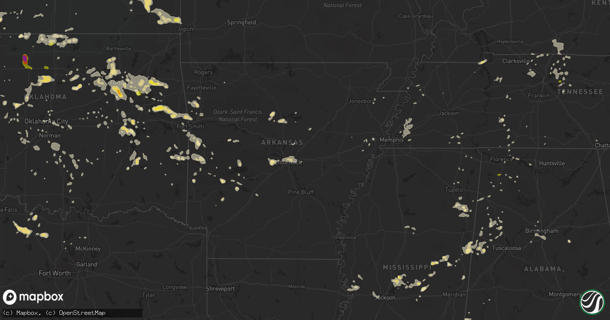
Hail Map in Arkansas on July 14, 2016
Get this storm
July 14 map
$229
one time, instant access
Download today. No call, no setup
Keep the $229
Bought the map and want the full workflow? Apply the entire $229 to a subscription within 7 days. None of it is wasted.
Every map, not just this one
This buys you this map. Subscription and you get every map we run, in the markets you choose from a few cities to whole states to nationwide. Plus real-time alerts the moment a storm fires.
Contact data
Name, contact info, occupancy, even credit band for addresses in the footprint. You go from where it hit to who to call.
Become the source they trust
Unlimited branding weather history reports on demand. You already have the documented answer ready for the property owner, and you are the one who showed up with it.
Property data and RoofTrace estimates
Pull up any address you have got, its value and the exact code rules for that jurisdiction, straight from One Click Code. Then RoofTrace estimates the squares, pitch, and roof value, priced the way you price.
Storm reports in Arkansas
Arkansas
| Date | Description |
|---|---|
| 07/14/20166:54 PM CDT | 59 mph gust eld asos |
| 07/14/20166:50 PM CDT | Trees and power lines down county wide. Out building in pine bluff destroyed by a falling tree. |
| 07/14/20166:50 PM CDT | Tree reported down. |
| 07/14/20166:50 PM CDT | Large tree down in smackover on vehicle |
| 07/14/20166:50 PM CDT | Winds gusted to 64 mph at pine bluff grider field airport. |
| 07/14/20166:40 PM CDT | Numerous trees were blown down in the county. |
| 07/14/20166:40 PM CDT | Numerous chicken houses damaged in the rison area. |
| 07/14/20166:40 PM CDT | E 70 mph wind. |
| 07/14/20166:26 PM CDT | A local report indicates 60 MPH wind near LITTLE ROCK AIRPORT |
| 07/14/20166:20 PM CDT | Large tree and power lines down on spruce street... Also trees and powerlines down on 29 south of town |
| 07/14/20166:15 PM CDT | Trees and power lines reported down in hope and outside the city limits as well |
| 07/14/20166:15 PM CDT | Trees were blown down in sheridan and all over the county. |
| 07/14/20166:15 PM CDT | Trees and power lines reported down all over the county |
| 07/14/20166:13 PM CDT | A local report indicates 68 MPH wind near LITTLE ROCK AIRPORT |
| 07/14/20166:13 PM CDT | The little rock adams field weather observer reported damage to the canopies in front of little rock airport. |
| 07/14/20166:05 PM CDT | Three large trees were uprooted at dickey-stephens park in downtown north little rock. |
| 07/14/20166:01 PM CDT | Trees were blown down across highway 53 south...taking power lines with them. |
| 07/14/20166:01 PM CDT | Trees were blown down on colonel glenn road...west of i-430...with the road impassable. |
| 07/14/20166:00 PM CDT | Trees were blown down on markham street. |
| 07/14/20165:55 PM CDT | Some shingles were blown off of the roof of a home on rivercrest drive. |
| 07/14/20165:55 PM CDT | 50 to 60 mph gusts measured in redland community 4 miles east of prescott. Numerous large limbs and some trees snapped off |
| 07/14/20165:50 PM CDT | Trees and power lines were blown down at lawson and sparks road. |
| 07/14/20165:45 PM CDT | Trees were blown down on the campus of ouachita baptist university. |
| 07/14/20165:40 PM CDT | Power lines reported down on jacks isle road and highway 32 near millwood lake |
| 07/14/20165:25 PM CDT | Trees were blown down on brady mountain road. |
| 07/14/20165:25 PM CDT | Trees were blown down. |
| 07/14/20165:20 PM CDT | Widespread damage. At least 3 large oak trees down. Two outbuildings destroyed. |
| 07/14/20165:15 PM CDT | Trees down north and west of nashville... As well as county wide |
| 07/14/20165:10 PM CDT | Trees were blown down...and some were on houses. |
| 07/14/20165:08 PM CDT | E 60 mph winds with numerous tree limbs down. Tree down at amity / harris rd caused power outage. |
| 07/14/20165:05 PM CDT | Trees and power lines down across county but heaviest damage in horatio and locksburg area |
| 07/14/20165:01 PM CDT | Trees were blown down. |
| 07/14/20165:00 PM CDT | A tree was blown down on a house. |
| 07/14/20165:00 PM CDT | Trees were blown down...and some were on houses. |
| 07/14/20164:45 PM CDT | Several trees down in city... Strong winds estimated at 70 mph |
| 07/14/20164:43 PM CDT | A local report indicates 59 MPH wind near RUSSELLVILLE |
| 07/14/20164:43 PM CDT | A tree was snapped off near its base. |
| 07/14/20164:40 PM CDT | Significant wind damage in mt ida. Numerous trees down across town with several homes receiving damage by falling trees. Some roofs were peeled back by the wind. |
| 07/14/20164:40 PM CDT | Trees were blown down on highway 270. |
| 07/14/20164:35 PM CDT | Numerous trees and power lines were blown down between danville and dardanelle. |
| 07/14/20164:20 PM CDT | Trees and power lines were blown down over the southern half of the county. |
| 07/14/20164:20 PM CDT | Widespread large trees down. Damage to homeowner roof. Power outages. |
| 07/14/20164:20 PM CDT | Widespread large trees down. Damage to homeowner roof. Power outages. |
| 07/14/20164:15 PM CDT | Trees were downed across highway 28 near parks. |
| 07/14/20164:10 PM CDT | A portion of a deck was blown over. Numerous large limbs were down. |
| 07/14/20164:05 PM CDT | *** 1 inj *** a tree fell on a truck...injuring one person. |
| 07/14/20164:05 PM CDT | Power lines were blown down in booneville across highway 109 and grove street. The fire department was responding due to a fire in the trees. |
| 07/14/20164:05 PM CDT | Trees were blown down near waldron and in other areas of northern scott county. |
| 07/14/20164:05 PM CDT | Power lines were blown down. |
| 07/14/20163:59 PM CDT | Damage to trees was reported...and some shingles were blown off of roofs. |
| 07/14/20163:50 PM CDT | Large trees were blown down. |
| 07/14/20163:50 PM CDT | West creek road completely blocked by downed trees and power lines. Time estimated via radar. |
| 07/14/20163:42 PM CDT | Tree damage |
| 07/14/20163:40 PM CDT | 8 inch diameter pine laying across pilot grove loop off of highway 309 south. Time estimated via radar. |
| 07/14/20163:40 PM CDT | Trees down. Time estimated via radar. |
| 07/14/20163:40 PM CDT | Large tree fell on a mobile home...severely damaging it. Time estimated via radar. Photo relayed via broadcast media social media account. |
| 07/14/20163:30 PM CDT | Large trees down across wire road. Time estimated. |
| 07/14/20163:30 PM CDT | Large tree downed. Power out. Other widespread tree limb damage. Photo received via social media. Relayed by broadcast media. Time estimated. |
| 07/14/20163:17 PM CDT | Multiple large tree branches downed. Power out in town. Estimated to be at least 60 to 70 mph winds. Report relayed via social media. |
| 07/14/20163:17 PM CDT | Large tree downed. Photo received via social media. |
| 07/14/20163:15 PM CDT | Significant roof damage to a log home business. Time estimated via radar. Photo relayed via broadcast media social media account. |
| 07/14/20163:05 PM CDT | Power poles snapped. Relayed via social media. |
| 07/14/20163:00 PM CDT | Tree down |
| 07/13/20167:55 PM CDT | Trees and powerlines downed all through the city. |
| 07/13/20167:45 PM CDT | Trees were downed due to strong straight line winds. |
| 07/13/20167:35 PM CDT | Large tree snapped on timberlane at the old high... West side of el dorado |
| 07/13/20167:28 PM CDT | The roof was blown off of three businesses in town. |
| 07/13/20167:25 PM CDT | Trees and signs were blown down. |
| 07/13/20167:15 PM CDT | A tree fell on a house. |
| 07/13/20167:10 PM CDT | Several trees down in town. One building on the square lost half the roof. Power lines down. |
| 07/13/20167:05 PM CDT | Trees were blown down. |
| 07/13/20167:00 PM CDT | Trees and power lines reported down county wide |
All States Impacted by Hail Map on July 14, 2016
Cities Impacted by Hail Map on July 14, 2016
- Eldorado, OK
- Gould, OK
- Bowman, ND
- Pueblo, CO
- Kingfisher, OK
- Claude, TX
- Mer Rouge, LA
- Sand Springs, OK
- Cleveland, OK
- Mannford, OK
- Terlton, OK
- Cody, NE
- Pine Ridge, SD
- Manderson, SD
- Lakeside, NE
- Alliance, NE
- Ellsworth, NE
- Hamilton, KS
- Kyle, SD
- Scenic, SD
- Custer City, OK
- Murfreesboro, AR
- Childress, TX
- Quanah, TX
- Mentone, TX
- Floydada, TX
- Petersburg, TX
- Lockney, TX
- Tahlequah, OK
- Preston, MS
- Midland, TX
- Hammon, OK
- Leedey, OK
- Cheyenne, OK
- Kit Carson, CO
- Hastings, FL
- East Palatka, FL
- San Mateo, FL
- Blackwell, OK
- Braman, OK
- Nardin, OK
- Pocasset, OK
- Chickasha, OK
- Gordo, AL
- Carrollton, AL
- Jessieville, AR
- Taloga, OK
- Hendersonville, TN
- Amory, MS
- Aberdeen, MS
- Reva, SD
- Belleville, IL
- Model, CO
- Prairie City, SD
- Madison, KS
- Batesland, SD
- Valentine, NE
- Kilgore, NE
- Wanblee, SD
- Martin, SD
- Merriman, NE
- Tuthill, SD
- Porcupine, SD
- Nenzel, NE
- Thedford, NE
- Allen, SD
- Johnstown, NE
- Hodgen, OK
- Alpine, AL
- Talladega, AL
- Gladstone, NM
- Faith, SD
- Eufaula, OK
- Heavener, OK
- Groom, TX
- Oshkosh, NE
- Bingham, NE
- Hyannis, NE
- Ashby, NE
- Pleasant View, TN
- Ashland City, TN
- Seibert, CO
- Flagler, CO
- Stratton, CO
- Vona, CO
- Erie, KS
- Galesburg, KS
- Parsons, KS
- Patriot, IN
- Rising Sun, IN
- Kermit, TX
- Caneyville, KY
- Weleetka, OK
- Henryetta, OK
- Dickens, TX
- Maize, KS
- Robards, KY
- Circle, MT
- Haven, KS
- Inola, OK
- Bristow, IN
- Saint Meinrad, IN
- Seagraves, TX
- Broken Bow, OK
- Wagoner, OK
- Porter, OK
- Coweta, OK
- Nocona, TX
- Waldron, AR
- Farragut, TN
- Knoxville, TN
- Franklin, LA
- Millington, TN
- Arlington, TN
- Memphis, TN
- Brownfield, TX
- Lemmon, SD
- Meadow, SD
- Mansfield, AR
- Huntington, AR
- Yale, OK
- Hayes Center, NE
- Colorado Springs, CO
- Cedar Hill, TN
- Hamilton, MS
- Brewster, NE
- Anselmo, NE
- Erin, TN
- Waverly, TN
- Osage, OK
- Prue, OK
- Wilburton, OK
- Hartshorne, OK
- Groton, VT
- Sun City, KS
- Wilmore, KS
- Greeneville, TN
- Fountain, CO
- Fairview, KS
- Seneca, KS
- Vermillion, KS
- Oneida, KS
- Corning, KS
- Frankfort, KS
- Goff, KS
- Sabetha, KS
- Centralia, KS
- Arthur, NE
- Castle, OK
- Okemah, OK
- Bixby, OK
- Weston, CO
- Huntington, WV
- South Point, OH
- Okarche, OK
- Caddo Gap, AR
- Glendive, MT
- Diamond, MO
- Carthage, MO
- Sarcoxie, MO
- Hydro, OK
- Paoli, OK
- Pauls Valley, OK
- Scottsville, KY
- Duncan, OK
- Rhame, ND
- Colwich, KS
- Sharon, KS
- Haigler, NE
- Wray, CO
- Snyder, TX
- Oakwood, OK
- Canton, OK
- Watonga, OK
- Peyton, CO
- Elbert, CO
- Hampstead, NC
- Wilmington, NC
- Covington, OK
- Lucien, OK
- Marshall, OK
- Perry, OK
- Orlando, OK
- Levelland, TX
- Ropesville, TX
- Lubbock, TX
- Smyer, TX
- Catoosa, OK
- Scranton, ND
- Gallatin, TN
- Lebanon, TN
- Castalian Springs, TN
- Mount Juliet, TN
- Edmond, OK
- Plains, TX
- Ludowici, GA
- Allenhurst, GA
- Bumpass, VA
- Iowa Park, TX
- Burns, KS
- Peabody, KS
- Newton, KS
- Galena, KS
- Cherokee, KS
- McCune, KS
- Pittsburg, KS
- Scammon, KS
- Columbus, KS
- Carl Junction, MO
- Weir, KS
- Asbury, MO
- Yuma, CO
- Haxtun, CO
- Holyoke, CO
- Bellevue, TX
- Duck Hill, MS
- Winona, MS
- Seymour, TX
- Checotah, OK
- Scott Depot, WV
- Saint Albans, WV
- Winfield, WV
- Covington, TN
- Brighton, TN
- Atoka, TN
- Bokeelia, FL
- Green Mountain, NC
- Chanute, KS
- Walsenburg, CO
- Glencoe, OK
- Pawnee, OK
- Louisville, MS
- Hohenwald, TN
- Quitaque, TX
- Silverton, TX
- Lewellen, NE
- Lemoyne, NE
- Branson, CO
- Bastrop, LA
- Porterville, MS
- Crown City, OH
- Bedford, VA
- Huddleston, VA
- Yoder, CO
- Scott, AR
- Venice, FL
- Englewood, FL
- Calvin, OK
- Harrold, TX
- Electra, TX
- Slaton, TX
- Stillwater, OK
- Ripley, OK
- Cushing, OK
- Van Buren, AR
- Vian, OK
- Muskogee, OK
- Rudy, AR
- Bunch, OK
- Braggs, OK
- Muldrow, OK
- Cookson, OK
- Park Hill, OK
- Sallisaw, OK
- Uniontown, AR
- Adamsville, TN
- Corydon, IN
- Battletown, KY
- Canyon, TX
- Amarillo, TX
- New Florence, MO
- Lake City, FL
- Tulsa, OK
- Barnsdall, OK
- Skiatook, OK
- Sperry, OK
- Ocate, NM
- Sapello, NM
- Rainsville, NM
- Jenks, OK
- Mounds, OK
- Glenpool, OK
- Sapulpa, OK
- Chesapeake, OH
- Proctorville, OH
- Calhoun, KY
- Brule, NE
- Mullen, NE
- Whitman, NE
- Clendenin, WV
- Evington, VA
- Widener, AR
- Heth, AR
- Wolf Point, MT
- Medford, OK
- Millport, AL
- Reform, AL
- Ethelsville, AL
- Trementina, NM
- Clearwater, KS
- Hendley, NE
- Beaver City, NE
- Canton, MS
- Noxapater, MS
- Paden, OK
- Andale, KS
- Branchville, IN
- Leopold, IN
- Saint Croix, IN
- Hutchinson, KS
- Broken Arrow, OK
- Ludlow, SD
- Columbus, MS
- Skellytown, TX
- Trinidad, CO
- Vernon, TX
- Wagon Mound, NM
- Stigler, OK
- Scottown, OH
- Garita, NM
- Fay, OK
- Thomas, OK
- Morris, OK
- Ringgold, TX
- Piedmont, OK
- Joelton, TN
- Bomont, WV
- Larslan, MT
- Yates Center, KS
- Fredonia, KS
- Buffalo, KS
- Eads, CO
- Cedar Point, KS
- Pennington, AL
- Hedley, TX
- Amber, OK
- Verden, OK
- Philadelphia, MS
- Geary, OK
- Hinton, OK
- Manitou Springs, CO
- Meadow, TX
- Tulia, TX
- Burlington, CO
- Bethune, CO
- Chester, AR
- Many, LA
- Callaway, NE
- Broken Bow, NE
- Macon, MS
- Plainview, TX
- Byars, OK
- Stratford, OK
- Blanco, OK
- Tuskahoma, OK
- Pittsburg, OK
- Medicine Lake, MT
- Mud Butte, SD
- Morriston, FL
- Pass Christian, MS
- Kiln, MS
- Diamondhead, MS
- Seminole, TX
- Mcalester, OK
- Haileyville, OK
- Crosbyton, TX
- Mcadoo, TX
- Oconto, NE
- Pampa, TX
- Norman, AR
- Attica, KS
- Little Rock, AR
- Jacksonville, AR
- Sherwood, AR
- North Little Rock, AR
- Irvine, KY
- Winchester, KY
- Clay City, KY
- Okatie, SC
- Savonburg, KS
- Columbia, MS
- Lake, MS
- Forest, MS
- Conehatta, MS
- Bowie, TX
- Throckmorton, TX
- Franklin, KY
- Alvaton, KY
- Bowling Green, KY
- Woodburn, KY
- Chillicothe, TX
- Quitman, AR
- Heber Springs, AR
- Boley, OK
- Butler, OK
- Woodbine, GA
- Wynne, AR
- Pryor, OK
- Aliceville, AL
- Bloomfield, MT
- Bolton, MS
- Raymond, MS
- Jackson, MS
- Clinton, MS
- Milesville, SD
- Cherry Creek, SD
- Springfield, TN
- Arlington, KS
- Partridge, KS
- West Mineral, KS
- Saint Paul, KS
- Russellville, AL
- Reydon, OK
- Sweetwater, OK
- Houston, AL
- Addison, AL
- Monticello, MS
- Moulton, AL
- White Deer, TX
- Amity, AR
- Clay, WV
- Maysel, WV
- Indore, WV
- Greenfield, OK
- Calhan, CO
- Manila, AR
- Manchester, OK
- Altoona, KS
- Mena, AR
- Quail, TX
- Arriba, CO
- Monroe, NH
- East Ryegate, VT
- McIndoe Falls, VT
- Eunice, NM
- Andrews, TX
- Arkadelphia, AR
- Donaldson, AR
- Cove, AR
- Vandervoort, AR
- Alva, OK
- Hugo, CO
- Clinton, OK
- Lelia Lake, TX
- Clarendon, TX
- Culbertson, NE
- Linden, TN
- Okmulgee, OK
- Council Hill, OK
- Keystone, NE
- Lisco, NE
- Chouteau, OK
- Nickerson, KS
- Liberty, MS
- Weatherford, OK
- Toronto, KS
- Conway Springs, KS
- Mayfield, KS
- Argonia, KS
- Lenoir City, TN
- Bear Creek, AL
- Haleyville, AL
- Milton, WV
- Glenwood, WV
- Ona, WV
- Bomoseen, VT
- Florence, VT
- Pittsford, VT
- Brandon, VT
- Castleton, VT
- Georgetown, FL
- Crescent City, FL
- Tuttle, OK
- Newcastle, OK
- Douglas, OK
- Dover, OK
- Hennessey, OK
- Medicine Lodge, KS
- Clinton, AR
- Scotland, AR
- Oklahoma City, OK
- Wayne, OK
- New Concord, KY
- Buchanan, TN
- Celina, TX
- Locust Grove, OK
- Gulfport, MS
- Waynesboro, TN
- Fayette, AL
- Ramer, TN
- Homosassa, FL
- Burden, KS
- Hominy, OK
- Winslow, AR
- Shuqualak, MS
- Falmouth, KY
- Olustee, OK
- Elmer, OK
- Odell, TX
- Fitzpatrick, AL
- La Junta, CO
- West Fork, AR
- Waynesboro, MS
- Sulphur, OK
- Wink, TX
- Allen, OK
- Argillite, KY
- Harper, KS
- Spivey, KS
- Brooksville, MS
- Ardmore, OK
- Du Bois, NE
- Pawnee City, NE
- Baileyville, KS
- Westmoreland, TN
- Bethpage, TN
- Porum, OK
- Wakita, OK
- Lexington, OK
- Purcell, OK
- Beaverton, AL
- Guin, AL
- Elsie, NE
- Washington, OK
- Tanner, AL
- Athens, AL
- Baton Rouge, LA
- Drumright, OK
- Bristow, OK
- Pretty Prairie, KS
- Ramah, CO
- Andrews, SC
- Georgetown, SC
- Sarasota, FL
- Lodgepole, SD
- Sims, AR
- Story, AR
- Saint Marys, GA
- Kingsland, GA
- Yulee, FL
- Callahan, FL
- Ada, OK
- Roff, OK
- Dale, IN
- Benedict, KS
- Wayside, TX
- Happy, TX
- Forrest City, AR
- Redwood, MS
- Lindsay, OK
- Maysville, OK
- Boles, AR
- Denton, TX
- Bankston, AL
- Berry, AL
- Vilonia, AR
- Newkirk, OK
- Haskell, OK
- Proctor, OK
- Rose, OK
- Kiefer, OK
- Peggs, OK
- Claremore, OK
- Owasso, OK
- Greenwood Springs, MS
- Amherst, VA
- Madison Heights, VA
- Bush, LA
- Abita Springs, LA
- Covington, LA
- Mcloud, OK
- Newalla, OK
- Olive Hill, KY
- Davidson, OK
- Biloxi, MS
- Ocean Springs, MS
- Vancleave, MS
- Stonewall, OK
- Waco, KY
- Spur, TX
- Cleo Springs, OK
- Auburn, KY
- Booneville, MS
- Killen, AL
- Prairie Grove, AR
- Canehill, AR
- Bison, SD
- Lascassas, TN
- Cannelton, IN
- Island, KY
- Deridder, LA
- Kirk, CO
- Dyersburg, TN
- Montague, TX
- Buffalo, SD
- Morton, MS
- Lena, MS
- Matador, TX
- Caseyville, IL
- East Saint Louis, IL
- Fairview Heights, IL
- Valley Park, MS
- Hanna, OK
- Kaw City, OK
- Clayton, OK
- Nunnelly, TN
- McEwen, TN
- Decatur, TX
- Forestburg, TX
- Alvord, TX
- Gridley, KS
- Collierville, TN
- Eads, TN
- Rocky Ford, CO
- Union, MS
- Girard, TX
- Crowder, OK
- Davis, OK
- Bertrand, NE
- Ansley, NE
- Bridgeport, NE
- Afton, TX
- Putnam, OK
- Greenup, KY
- Carthage, MS
- Camden, MS
- Brandon, MS
- Adair, IA
- Anita, IA
- Ratliff City, OK
- Stringer, MS
- Lavalette, WV
- Virgil, KS
- Olpe, KS
- Humboldt, KS
- Fall River, KS
- Thayer, KS
- Frankewing, TN
- Fayetteville, TN
- Ararat, VA
- Meadows Of Dan, VA
- Dunning, NE
- Taylor, NE
- Mason, TN
- Cordova, TN
- Clyde, NC
- Glenwood, AR
- Bonnerdale, AR
- Adamsville, AL
- Gordon, AL
- Laurel, IA
- Melbourne, IA
- Newton, IA
- Holliday, TX
- Calumet, OK
- Mount Hope, KS
- Cleveland, AR
- Havana, AR
- Summerville, SC
- Blaine, KY
- Webbville, KY
- Arapaho, OK
- Greenwood, AR
- Alexander, AR
- Saltillo, MS
- Iron City, TN
- De Mossville, KY
- Sunset, TX
- Paducah, TX
- Eckley, CO
- Oden, AR
- Loretto, TN
- Cottontown, TN
- Bradenton, FL
- Moundridge, KS
- Englewood, TN
- Springer, OK
- Crawfordsville, AR
- Bern, KS
- Neodesha, KS
- Bishopville, SC
- Sumter, SC
- Dalzell, SC
- Gilbertown, AL
- Silas, AL
- Union Hall, VA
- Pierce City, MO
- Joplin, MO
- Webb City, MO
- Wentworth, MO
- Duenweg, MO
- Hamilton, AL
- Arcadia, OK
- Matheson, CO
- Dixon, KY
- Slaughters, KY
- Saint Louis, MO
- Sylvester, TX
- Rolling Fork, MS
- Marlow, OK
- Chico, TX
- Henrietta, TX
- Orlinda, TN
- Portland, TN
- Bainbridge, GA
- Montpelier, VT
- Plainfield, VT
- Adamant, VT
- East Montpelier, VT
- Arkansas City, KS
- Shubuta, MS
- Panhandle, TX
- Lancaster, KY
- Danville, KY
- Eustis, FL
- Brookhaven, MS
- Wesson, MS
- Paris, TN
- Center, TX
- Sebree, KY
- Ridgeland, SC
- La Harpe, KS
- Lawrenceburg, TN
- Mount Hope, AL
- Joes, CO
- Memphis, TX
- Bee Branch, AR
- Choctaw, AR
- Fort Gibson, OK
- Hulbert, OK
- Wellington, TX
- Kellyville, OK
- Beulah, CO
- Madill, OK
- Longdale, OK
- Beaver Dam, KY
- Cromwell, KY
- Carbon Hill, AL
- Eldridge, AL
- Red Rock, OK
- Turkey, TX
- Wallace, NE
- Westpoint, TN
- Exira, IA
- Tokio, TX
- Moweaqua, IL
- Bethany, IL
- Glen, MS
- Perryville, KY
- Solano, NM
- Paxton, NE
- Roby, TX
- Rotan, TX
- Bethel Springs, TN
- Selmer, TN
- Royal, AR
- Prague, OK
- Norman, OK
- Vicksburg, MS
- Stennis Space Center, MS
- Bay Saint Louis, MS
- Minco, OK
- Saint Martinville, LA
- Hillsville, VA
- Claudville, VA
- Stamps, AR
- Fort Meade, FL
- Frostproof, FL
- Jennings, LA
- Walnut Grove, MS
- Girard, IL
- Farmersville, IL
- Big Spring, TX
- Kennedy, AL
- Shawnee, OK
- Honobia, OK
- Smithville, OK
- Detroit, AL
- Northport, AL
- Tribune, KS
- Marshalltown, IA
- Culloden, WV
- Hurricane, WV
- Bronston, KY
- Arapahoe, NC
- Black Oak, AR
- Birmingham, AL
- Pelham, AL
- Humboldt, NE
- Castle Hayne, NC
- Rye, CO
- Nettleton, MS
- Gentryville, IN
- Ferdinand, IN
- Huntingburg, IN
- Stendal, IN
- Holland, IN
- Palmerton, PA
- Crab Orchard, KY
- Stanford, KY
- Appomattox, VA
- Gladstone, VA
- Richey, MT
- Booneville, AR
- Reserve, MT
- Toxey, AL
- Needham, AL
- Rogersville, AL
- Powell, TN
- Heiskell, TN
- Collinsville, OK
- Mooreland, OK
- Union, KY
- Russellville, KY
- Nashville, AR
- Aubrey, TX
- Watertown, TN
- Granite City, IL
- Parkin, AR
- Riceboro, GA
- Jennings, OK
- Ripley, TN
- Rembert, SC
- Springer, NM
- Searcy, AR
- Owensboro, KY
- Evansville, AR
- Wynnewood, OK
- Florence, KS
- Rockford, AL
- Florissant, CO
- Henderson, KY
- Pilgrim, KY
- Lovely, KY
- Smithfield, NE
- Ponca City, OK
- Mora, NM
- Waterloo, AL
- Beggs, OK
- Muscle Shoals, AL
- Jasper, TN
- Alma, AR
- Mulberry, AR
- Mountainburg, AR
- Vida, MT
- Apopka, FL
- Guthrie, OK
- Eubank, KY
- Olmstead, KY
- Adairville, KY
- Adams, TN
- Hackleburg, AL
- Morrison, OK
- Lewisburg, KY
- Sharon Grove, KY
- Paron, AR
- Benton, AR
- Spiro, OK
- Sweet Water, AL
- Smithville, MS
- Hodges, AL
- Blanchard, OK
- Alex, OK
- Elrod, AL
- Mount Olive, AL
- Morganfield, KY
- Madison, IN
- Williamson, WV
- Apple Grove, WV
- Fraziers Bottom, WV
- Grayson, KY
- Belleville, AR
- Flatwoods, KY
- Worthington, KY
- Russell, KY
- Lynnville, TN
- Barboursville, WV
- Bessemer, AL
- Fairfield, AL
- Maramec, OK
- Whitesburg, TN
- Bulls Gap, TN
- Mosheim, TN
- Mohawk, TN
- Kilmichael, MS
- Anadarko, OK
- Hillsboro, KS
- Grayson, LA
- Garwin, IA
- Sequatchie, TN
- McCalla, AL
- Pearcy, AR
- Bismarck, AR
- Ripley, WV
- Hesston, KS
- Deer Creek, OK
- Amorita, OK
- Rushville, NE
- Okolona, MS
- Buena Vista, NM
- Isabella, OK
- Okeene, OK
- Riceville, TN
- Etowah, TN
- Athens, TN
- Delano, TN
- Danville, WV
- Duke, OK
- Donaldsonville, LA
- Belle Rose, LA
- State Road, NC
- Higden, AR
- Edgemont, AR
- Pocola, OK
- Fort Smith, AR
- Hackett, AR
- Cameron, OK
- Madrid, NE
- Grant, NE
- Union City, OK
- El Reno, OK
- Anna, TX
- Van Alstyne, TX
- Lynch Station, VA
- Hardeeville, SC
- Quinton, OK
- Breeden, WV
- Dingess, WV
- Florence, AL
- Rocky Mount, VA
- Glade Hill, VA
- Parks, AR
- Sanger, TX
- Roland, OK
- Danville, AR
- Butler, AL
- Millry, AL
- Rustburg, VA
- Phil Campbell, AL
- Marion, KS
- Clinton, TN
- Wilson, OK
- Scooba, MS
- De Kalb, MS
- Hornsby, TN
- Hot Springs National Park, AR
- Saint Joseph, TN
- Owenton, KY
- Huntsville, AR
- Ashland, KY
- Parks, NE
- Talihina, OK
- Wolfforth, TX
- Monroe, TN
- O'Fallon, IL
- Lebanon, IL
- Scott Air Force Base, IL
- Burnsville, MS
- Elsmere, NE
- Saint Johnsbury, VT
- Littleton, NH
- Robeline, LA
- Rockport, IN
- Grandview, IN
- Madisonville, KY
- Independence, KY
- Oktaha, OK
- Taft, OK
- Taft, TN
- Wister, OK
- Poteau, OK
- Pocahontas, TN
- Hollis, OK
- Ralston, OK
- Denver City, TX
- Wounded Knee, SD
- Hodgenville, KY
- Kress, TX
- Waverly, GA
- Perkinston, MS
- Bunnell, FL
- Guntown, MS
- Trenton, TN
- Axtell, KS
- Jackson, OH
- Stuart, VA
- Hazelton, KS
- Fountain Run, KY
- Waynesville, GA
- Lake City, AR
- Briscoe, TX
- Lenox, TN
- Nahunta, GA
- Camden, SC
- Choctaw, OK
- Lexington, AL
- Finley, TN
- Abbyville, KS
- Soso, MS
- Dupree, SD
- Pond Creek, OK
- Nash, OK
- Carrier, OK
- Enid, OK
- Kremlin, OK
- Garber, OK
- Avondale, CO
- Trinchera, CO


