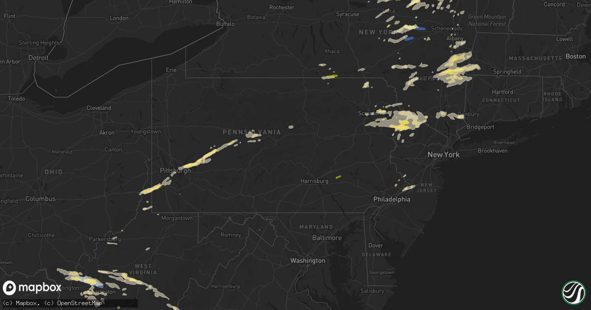
Hail Map in Pennsylvania on July 13, 2023
Get this storm
July 13 map
$229
one time, instant access
Download today. No call, no setup
Keep the $229
Bought the map and want the full workflow? Apply the entire $229 to a subscription within 7 days. None of it is wasted.
Every map, not just this one
This buys you this map. Subscription and you get every map we run, in the markets you choose from a few cities to whole states to nationwide. Plus real-time alerts the moment a storm fires.
Contact data
Name, contact info, occupancy, even credit band for addresses in the footprint. You go from where it hit to who to call.
Become the source they trust
Unlimited branding weather history reports on demand. You already have the documented answer ready for the property owner, and you are the one who showed up with it.
Property data and RoofTrace estimates
Pull up any address you have got, its value and the exact code rules for that jurisdiction, straight from One Click Code. Then RoofTrace estimates the squares, pitch, and roof value, priced the way you price.
Storm reports in Pennsylvania
Pennsylvania
| Date | Description |
|---|---|
| 07/13/20236:57 PM CDT | Mostly pea to nickel size with largest hail around quarter size. Time estimated based on radar. |
| 07/13/20236:55 PM CDT | Tree down on south forge road. |
| 07/13/20236:54 PM CDT | Report of trees down in the area. Time estimated based on radar. |
| 07/13/20236:54 PM CDT | A local report indicates 1.00 inch wind near Taylorstown |
| 07/13/20236:53 PM CDT | A local report indicates 1.00 inch wind near West Alexander |
| 07/13/20236:42 PM CDT | Trees down across roadway on state route 92n near oakland. |
| 07/13/20236:08 PM CDT | Along route 402. Radar-estimated time. Reported to nws via social media. |
| 07/13/20235:57 PM CDT | Tree down on wires on kimbles rd. |
| 07/13/20235:34 PM CDT | Sent in via social media with picture. Radar-estimated time. |
| 07/12/202311:07 PM CDT | Trees down on renovo rd in grugan twp. Time estimated by radar. |
| 07/12/202311:00 PM CDT | Tree on power lines on farrandsville rd. Time estimated by radar. |
| 07/12/202310:57 PM CDT | Trees on power lines. Time estimated by radar. |
| 07/12/20239:58 PM CDT | Tree down on coal hill road near riverview road. |
| 07/12/20239:45 PM CDT | Tree down on curwensville grampian highway. |
| 07/12/20239:44 PM CDT | Multiple trees and wires down. |
| 07/12/20239:41 PM CDT | Multiple trees down. |
| 07/12/20239:35 PM CDT | Tree down blocking whiskey run road at colonel drake highway. |
| 07/12/20239:26 PM CDT | Tree down across twin lakes road at don drive intersection. Reported to nws via social media. Radar-estimated time from main core of storm. |
| 07/12/20239:24 PM CDT | A tree was reported down over the intersection of ridge road and cloe rossier road. |
| 07/12/20238:50 PM CDT | A tree was reported down along route 403 in kenwood pa in indiana county. |
| 07/12/20238:44 PM CDT | Tree down on twin lake rd near rt 6. |
| 07/12/20238:38 PM CDT | A tree limb greater than 3 inch diameter was reported down on old route 119. |
| 07/12/20238:30 PM CDT | Trees down along route 286. Time estimated. |
| 07/12/20238:30 PM CDT | Tree down on old route 56. Time estimated. |
| 07/12/20238:10 PM CDT | Report and photo of trees snapped in half in bell township. Additional report of damage to outdoor window shutters and roof vent pulled up. Time estimated based on rada |
| 07/12/20238:07 PM CDT | Quarter to ping pong ball size hail reported in delaware township. |
| 07/12/20238:05 PM CDT | Report from mping: half dollar |
| 07/12/20237:53 PM CDT | Numerous trees down in upper burrell township. Time estimated. |
| 07/12/20237:50 PM CDT | Numerous trees down in the area. Time estimated. |
| 07/12/20237:45 PM CDT | Tree down on railroad. Time estimated. |
| 07/12/20237:42 PM CDT | Report and photo showing multiple trees down in penn hills area. Time estimated based on radar. |
| 07/12/20237:40 PM CDT | Tree down at intersection of gross street and mond way. Time estimated. |
| 07/12/20237:37 PM CDT | Photo showing large tree down. Time estimated based on radar. |
| 07/12/20237:36 PM CDT | Report of tree down on car outside west penn hospital. Time estimated based on radar. |
| 07/12/20237:35 PM CDT | Large tree down on road near intersection of gross street and friendship avenue. Time estimated. |
| 07/12/20237:34 PM CDT | Report of large tree limbs down on power lines in squirrel hill north. Time estimated based on radar. |
| 07/12/20237:24 PM CDT | Photo showing large tree on roadway that was snapped in half. Time estimated based on radar. |
| 07/12/20237:24 PM CDT | Report and photo of several large tree limbs snapped and medium size trees down. Time estimated based on radar. |
| 07/12/20237:21 PM CDT | Report from mping: 3-inch tree limbs broken; power poles broken. |
| 07/12/20237:20 PM CDT | Large branches torn off of a tree. Picture provided. Time estimated. |
| 07/12/20237:20 PM CDT | Tree down on car at the intersection of abbey lane and ridgebury drive. No injuries. Time estimated. |
| 07/12/20237:18 PM CDT | Measured on home weather station in north fayette township. Time estimated. |
| 07/12/20237:18 PM CDT | Tree blown down at the corner of pleasant and high steet. Time estimated based on radar. |
| 07/12/20237:14 PM CDT | A local report indicates 1.00 inch wind near 3 ESE Lebanon |
| 07/12/20237:12 PM CDT | Trees down on morgan hill road. Time estimated. |
| 07/12/20237:12 PM CDT | Photo showing large tree snapped near trunk. Time estimated based on radar. |
| 07/12/20237:08 PM CDT | Trees down over twin rocks road near creamery road. |
| 07/12/20237:07 PM CDT | A tree was reported down on powerlines on dickerson run road. |
| 07/12/20237:05 PM CDT | Report of tree blown down. Time estimated based on radar. |
| 07/12/20237:05 PM CDT | Located off of mcclay road. |
| 07/12/20237:00 PM CDT | Trees down on belgium hill road. Time estimated. |
All States Impacted by Hail Map on July 13, 2023
- Missouri
- Nebraska
- Kansas
- Colorado
- West Virginia
- New York
- Iowa
- Minnesota
- Virginia
- Ohio
- North Dakota
- South Dakota
- Texas
- Vermont
- Oklahoma
- New Mexico
- Montana
- Wyoming
- South Carolina
- North Carolina
- Indiana
- Kentucky
- Florida
- Mississippi
- Arkansas
- Georgia
- Pennsylvania
- Wisconsin
- Illinois
- New Jersey
- New Hampshire
- Massachusetts
- Connecticut
- Michigan
Cities Impacted by Hail Map on July 13, 2023
- Higbee, MO
- Armstrong, MO
- Salisbury, MO
- Fayette, MO
- Clark, MO
- Harrisburg, MO
- Columbia, MO
- Hallsville, MO
- Rocheport, MO
- Fulton, MO
- Ashland, MO
- New Bloomfield, MO
- Holts Summit, MO
- Tebbetts, MO
- Mokane, MO
- Chamois, MO
- Linn, MO
- Bonnots Mill, MO
- Minatare, NE
- Scottsbluff, NE
- Bayard, NE
- Angora, NE
- Bridgeport, NE
- Leslie, MO
- Gerald, MO
- Sullivan, MO
- Bourbon, MO
- Beaufort, MO
- Saint Clair, MO
- Mound City, KS
- Leasburg, MO
- Steelville, MO
- Potosi, MO
- Broadwater, NE
- Amsterdam, MO
- Amoret, MO
- Butler, MO
- Adrian, MO
- Richwoods, MO
- Blackwell, MO
- Cadet, MO
- Mineral Point, MO
- Belgrade, MO
- Montrose, MO
- Urich, MO
- Cope, CO
- Eleanor, WV
- Red House, WV
- Winfield, WV
- Mullen, NE
- Whitman, NE
- Sutherland, NE
- Ripley, WV
- Kenna, WV
- Davisville, WV
- Walker, WV
- Mineral Wells, WV
- Gandeeville, WV
- Given, WV
- Paxton, NE
- Hyannis, NE
- Gay, WV
- Hershey, NE
- Petroleum, WV
- Walton, WV
- Merriman, NE
- North Platte, NE
- Spencer, WV
- Newton, WV
- Chloe, WV
- Looneyville, WV
- Anton, CO
- Ivydale, WV
- Duck, WV
- Frametown, WV
- Yuma, CO
- Joes, CO
- Schroon Lake, NY
- Genoa, CO
- Arriba, CO
- Flagler, CO
- Seibert, CO
- North Hudson, NY
- Buffalo Center, IA
- Thompson, IA
- Scarville, IA
- Titonka, IA
- Woden, IA
- Lakota, IA
- Hugo, CO
- Big Island, VA
- Goode, VA
- Forest, VA
- Bolton Landing, NY
- Warrensburg, NY
- Brant Lake, NY
- Chestertown, NY
- Pottersville, NY
- Adirondack, NY
- Britt, IA
- Garner, IA
- Fraziers Bottom, WV
- Glenwood, WV
- Crown City, OH
- Ashton, WV
- Buffalo, WV
- Milton, WV
- Scott Depot, WV
- Hurricane, WV
- Poca, WV
- Karval, CO
- East Grand Forks, MN
- Grand Forks, ND
- Page, ND
- Hope, ND
- Buffalo, ND
- Wheatland, ND
- Absaraka, ND
- Amenia, ND
- Charleston, WV
- Kanawha, IA
- Goodell, IA
- Klemme, IA
- Dougherty, IA
- Sheffield, IA
- Aredale, IA
- Greene, IA
- Crookston, NE
- Wood Lake, NE
- Stratton, CO
- Kit Carson, CO
- Bethune, CO
- Cheyenne Wells, CO
- Casselton, ND
- Portland, ND
- Mayville, ND
- West Winfield, NY
- Salisbury Center, NY
- Stratford, NY
- Caroga Lake, NY
- Langford, SD
- Eden, SD
- Lake City, SD
- Roslyn, SD
- Peever, SD
- Grenville, SD
- Vega, TX
- Wildorado, TX
- Hereford, TX
- Bradley, SD
- Wallace, SD
- Florence, SD
- Watertown, SD
- South Shore, SD
- Henry, SD
- Doland, SD
- Carpenter, SD
- Willow Lake, SD
- Onida, SD
- Highmore, SD
- Orient, SD
- Johnstown, NE
- Mapleton, ND
- West Fargo, ND
- Harwood, ND
- Haswell, CO
- Bryant, SD
- De Smet, SD
- Miller, SD
- Springfield Center, NY
- Redfield, SD
- Cooperstown, NY
- East Springfield, NY
- Cherry Valley, NY
- Tulare, SD
- Jordanville, NY
- Canajoharie, NY
- Sharon Springs, NY
- Rockham, SD
- Schenevus, NY
- Worcester, NY
- Lynchburg, VA
- Fargo, ND
- Moorhead, MN
- Crowell, TX
- Strandburg, SD
- Pierre, SD
- Blunt, SD
- Arlington, CO
- Erwin, SD
- Sabin, MN
- Glyndon, MN
- Kim, CO
- Pritchett, CO
- Blacksburg, VA
- Lake Preston, SD
- Sprakers, NY
- Sloansville, NY
- Clemons, NY
- Huletts Landing, NY
- Hague, NY
- Whitehall, NY
- Putnam Station, NY
- Silver Bay, NY
- Sheridan Lake, CO
- Barnesville, MN
- Hawley, MN
- Las Animas, CO
- Vernon, TX
- Oklaunion, TX
- Harrold, TX
- Harrison, NE
- Happy, TX
- Crawford, NE
- Whitney, NE
- Fair Haven, VT
- Orwell, VT
- Wounded Knee, SD
- Manderson, SD
- Batesland, SD
- Interior, SD
- Philip, SD
- Kadoka, SD
- Porcupine, SD
- Kyle, SD
- Wanblee, SD
- Midland, SD
- Cherry Creek, SD
- Milesville, SD
- Harrisburg, NE
- Arlington, SD
- Pelican Rapids, MN
- Whiting, VT
- Shoreham, VT
- Sinai, SD
- Volga, SD
- Chadron, NE
- Hudson, NY
- Athens, NY
- Maynard, MN
- Montevideo, MN
- Sacred Heart, MN
- Clara City, MN
- Nunda, SD
- Davidson, OK
- Elkton, SD
- Lake Benton, MN
- Vergas, MN
- Salisbury, VT
- Erhard, MN
- Dent, MN
- Waverly, NY
- Chemung, NY
- Barton, NY
- Nichols, NY
- Stuyvesant, NY
- Raymond, MN
- Prinsburg, MN
- Blomkest, MN
- Lake Lillian, MN
- Hector, MN
- Fairfax, MN
- Gibbon, MN
- New Raymer, CO
- Winthrop, MN
- Mankato, MN
- Janesville, MN
- Stoneham, CO
- Pemberton, MN
- Mapleton, MN
- Minnesota Lake, MN
- Waldorf, MN
- Gering, NE
- Melbeta, NE
- Rutland, SD
- Colman, SD
- Flandreau, SD
- Dalton, NE
- Gordon, NE
- Martin, SD
- Richville, MN
- Battle Lake, MN
- Holly, CO
- Ottertail, MN
- Brooten, MN
- Belgrade, MN
- Cosmos, MN
- Lafayette, MN
- New Richland, MN
- Ruthton, MN
- Pipestone, MN
- Tyler, MN
- Holland, MN
- Egan, SD
- Pueblo, CO
- Henning, MN
- Frederick, OK
- Hollister, OK
- New London, MN
- Nicollet, MN
- New Ulm, MN
- Hartland, MN
- Gurley, NE
- Snyder, CO
- Cody, NE
- Byers, CO
- Deer Trail, CO
- Agate, CO
- Calhan, CO
- Ramah, CO
- Log Lane Village, CO
- Simla, CO
- Fort Morgan, CO
- Vining, MN
- Avondale, CO
- Boone, CO
- Roseau, MN
- Sauk Centre, MN
- Melrose, MN
- Freeport, MN
- Albany, MN
- Granada, CO
- Paynesville, MN
- Grenville, NM
- Malden On Hudson, NY
- Saugerties, NY
- Germantown, NY
- Elizaville, NY
- Saint Peter, MN
- Kasota, MN
- Waseca, MN
- Doniphan, MO
- Gatewood, MO
- Lower Brule, SD
- Grandin, ND
- Hillsboro, ND
- Ava, NY
- North River, NY
- Underwood, MN
- Janesville, IA
- Cedar Falls, IA
- Aneta, ND
- Northwood, ND
- Lower Salem, OH
- Fort Pierre, SD
- Dumont, IA
- Rockwell, IA
- Dupree, SD
- Lake Pleasant, NY
- Bickmore, WV
- Clay, WV
- Dolgeville, NY
- Cohagen, MT
- Malta, MT
- Elizabethtown, NY
- Hogeland, MT
- Richfield Springs, NY
- Brusett, MT
- Jordan, MT
- Wheatland, WY
- Guernsey, WY
- Oglala, SD
- Ceylon, MN
- Fairmont, MN
- Tabor City, NC
- Green Sea, SC
- Johnsburg, NY
- Burke, NY
- Malone, NY
- Chateaugay, NY
- Clinton, NY
- Myrtle, MO
- Osage, IA
- Saint Ansgar, IA
- Stacyville, IA
- Gallipolis, OH
- Vona, CO
- Harlem, MT
- Armstrong, IA
- Swea City, IA
- Badger, MN
- Conde, SD
- Pedro, OH
- Waterloo, OH
- Holabird, SD
- Sharon, ND
- Seymour, IN
- Blue Earth, MN
- Garrison, KY
- Arapahoe, CO
- Lusk, WY
- Marlinton, WV
- White Sulphur Springs, WV
- Catlettsburg, KY
- Rush, KY
- Couch, MO
- Blue Creek, OH
- Winchester, OH
- Ripley, OH
- Russellville, OH
- West Union, OH
- Ledyard, IA
- Remsen, NY
- Holland Patent, NY
- Westernville, NY
- Avon Park, FL
- Forestport, NY
- Cold Brook, NY
- Alder Creek, NY
- Boonville, NY
- Poland, NY
- Prospect, NY
- Ayr, ND
- Wallback, WV
- Elmore, MN
- Yorkville, NY
- Utica, NY
- New York Mills, NY
- New Hartford, NY
- Clewiston, FL
- Athens, OH
- New Marshfield, OH
- Monroe, VA
- Forest City, IA
- Diamond Point, NY
- Swaledale, IA
- Lesage, WV
- Garden City, SD
- Upperglade, WV
- Cowen, WV
- Clear Lake, IA
- Alkol, WV
- Sod, WV
- Sumerco, WV
- Alum Creek, WV
- Yawkey, WV
- Britton, SD
- Wesley, IA
- Northville, NY
- Wells, NY
- Stony Creek, NY
- Hartwick, NY
- Fly Creek, NY
- Burlington Flats, NY
- Harrold, SD
- Castorland, NY
- Carthage, NY
- New Berlin, NY
- Belleville, NY
- Kilgore, NE
- Valentine, NE
- Athol, NY
- Minerva, NY
- North Creek, NY
- Bakers Mills, NY
- Olmstedville, NY
- Paradox, NY
- Jay Em, WY
- Waverly, WV
- Saint Marys, WV
- Birch River, WV
- Webster, SD
- Bristol, SD
- Perkinston, MS
- Ainsworth, NE
- Tornado, WV
- South Charleston, WV
- Saint Albans, WV
- Torrington, WY
- Orlando, FL
- Breesport, NY
- Erin, NY
- Horseheads, NY
- Mohawk, NY
- Greenup, KY
- Rustburg, VA
- Hasty, CO
- Clark, SD
- Roseboom, NY
- Amherst, VA
- Rincon, GA
- Camden, WV
- Weston, WV
- Dazey, ND
- Rome, NY
- Barneveld, NY
- Patriot, OH
- Apple Grove, WV
- Thayer, MO
- Waynesboro, VA
- Fort Stewart, GA
- Granada, MN
- Beverly, OH
- Dexter City, OH
- Colton, SD
- Pine Ridge, SD
- Midway, GA
- Hinesville, GA
- Hot Springs, VA
- Lee Center, NY
- Taberg, NY
- Fleischmanns, NY
- Hillsboro, WV
- Fort Plain, NY
- Saint Johnsville, NY
- Leon, WV
- Scottown, OH
- Nitro, WV
- Gallipolis Ferry, WV
- Willow Wood, OH
- Proctorville, OH
- Clendenin, WV
- Hadley, NY
- Bancroft, IA
- Belmond, IA
- Lewisville, OH
- Woodsfield, OH
- Graysville, OH
- Millboro, VA
- Wessington, SD
- Saint Lawrence, SD
- Sherburne, NY
- Little Falls, NY
- Vernon Center, NY
- Marcy, NY
- Whitesboro, NY
- Oriskany Falls, NY
- Deansboro, NY
- Warm Springs, VA
- Elkview, WV
- Bomont, WV
- Bedford, VA
- Guyton, GA
- Ticonderoga, NY
- Hardeeville, SC
- Gloversville, NY
- Clayville, NY
- Ilion, NY
- Sauquoit, NY
- Frankfort, NY
- Cassville, NY
- Fairburn, SD
- Buffalo Gap, SD
- Blossvale, NY
- Lockwood, NY
- Big Sandy, MT
- Stockport, OH
- Punta Gorda, FL
- Des Moines, NM
- Mount Vision, NY
- New Lisbon, NY
- Garrattsville, NY
- Edmeston, NY
- Catskill, NY
- Palenville, NY
- Nebo, WV
- Webster Springs, WV
- Amma, WV
- Buckeye, WV
- Procious, WV
- Left Hand, WV
- Dille, WV
- Camden On Gauley, WV
- Glenwood, MN
- Madison, IN
- West Hamlin, WV
- Hamlin, WV
- Allenhurst, GA
- Pocahontas, AR
- Avon, MN
- Jasper, MN
- Hardwick, MN
- Kenton, OK
- Craryville, NY
- Ancram, NY
- Fowler, CO
- Eden Valley, MN
- Watkins, MN
- Litchfield, MN
- Saint Joseph, MN
- Eagle Lake, MN
- Madison Lake, MN
- Luverne, MN
- Beulah, CO
- Colorado City, CO
- Darwin, MN
- Dassel, MN
- Owatonna, MN
- Hope, MN
- Saint Cloud, MN
- Cokato, MN
- Blooming Prairie, MN
- Claremont, MN
- Magnolia, MN
- Kenneth, MN
- Adrian, MN
- Ellsworth, MN
- Hillsdale, NY
- Copake, NY
- West Camp, NY
- Hoffman, MN
- Kensington, MN
- Farwell, MN
- Lowry, MN
- Rye, CO
- Walsenburg, CO
- Clear Lake, MN
- Becker, MN
- Howard Lake, MN
- Waverly, MN
- Watertown, MN
- Montrose, MN
- Springfield, CO
- Boise City, OK
- Avella, PA
- Valley Grove, WV
- Claysville, PA
- Washington, PA
- West Alexander, PA
- New Kensington, PA
- Pittsburgh, PA
- Verona, PA
- Lebanon, PA
- Myerstown, PA
- Apollo, PA
- Leechburg, PA
- Spring Church, PA
- Avonmore, PA
- Penrose, CO
- Model, CO
- Big Lake, MN
- Campo, CO
- Elk River, MN
- Clayton, NM
- Shelocta, PA
- Monticello, MN
- Creekside, PA
- Indiana, PA
- Texline, TX
- Little Rock, IA
- Aguilar, CO
- Sibley, IA
- Trinidad, CO
- La Veta, CO
- Weston, CO
- Ocheyedan, IA
- Melvin, IA
- Home, PA
- Marion Center, PA
- Anoka, MN
- Dayton, MN
- Minneapolis, MN
- Andover, MN
- Kellogg, IA
- Albion, IA
- Gilman, IA
- Marshalltown, IA
- Ferguson, IA
- Grinnell, IA
- Dalhart, TX
- Keyes, OK
- Trinchera, CO
- Boncarbo, CO
- Texhoma, OK
- Raton, NM
- Walters, OK
- Fredericksburg, IA
- New Hampton, IA
- Sumner, IA
- Westgate, IA
- Maynard, IA
- Oelwein, IA
- Hazleton, IA
- Folsom, NM
- Plainview, MN
- Millville, MN
- Altura, MN
- Rollingstone, MN
- Lewiston, MN
- Winona, MN
- Maxwell, NM
- Springer, NM
- Felt, OK
- Rushford, MN
- Houston, MN
- Dakota, MN
- La Crescent, MN
- Carlos, MN
- Nelson, MN
- Alexandria, MN
- Garfield, MN
- Brandon, MN
- Renick, WV
- East Greenbush, NY
- East Schodack, NY
- Arthur, NE
- Sauk Rapids, MN
- Sartell, MN
- Foley, MN
- Rice, MN
- Millerton, NY
- Stillwater, NY
- Schuylerville, NY
- Saratoga Springs, NY
- Peytona, WV
- Racine, WV
- Oshkosh, NE
- Ashby, NE
- Montour, IA
- Garwin, IA
- Toledo, IA
- Greeley, PA
- Hawley, PA
- Stanley, WI
- Boyd, WI
- Mayer, MN
- Honesdale, PA
- Livingston Manor, NY
- Saint Paul, MN
- Wheeling, WV
- Clarissa, MN
- Eagle Bend, MN
- Browerville, MN
- Kimball, MN
- South Haven, MN
- Annandale, MN
- Schoharie, NY
- Barrett, MN
- Austerlitz, NY
- Martins Ferry, OH
- Triadelphia, WV
- Bellaire, OH
- Bridgeport, OH
- Tuthill, SD
- Saint Francis, SD
- Hartley, IA
- Melbourne, AR
- Foster, WV
- Wannaska, MN
- Tampico, IL
- Amarillo, TX
- Canyon, TX
- Walnut, IL
- New Bedford, IL
- Deer Grove, IL
- El Reno, OK
- Adrian, TX
- Iowa Falls, IA
- Steamboat Rock, IA
- Williford, AR
- Hardy, AR
- Koshkonong, MO
- Ravenden Springs, AR
- Imboden, AR
- Elmira, NY
- Gillett, PA
- Wellsburg, NY
- Sayre, PA
- Hernshaw, WV
- Bushkill, PA
- Layton, NJ
- Canadensis, PA
- Tamiment, PA
- Columbia, NJ
- Dingmans Ferry, PA
- West Coxsackie, NY
- Iroquois, SD
- Meservey, IA
- Alexander, IA
- Calumet, OK
- Quitaque, TX
- Hickory, NC
- Connelly Springs, NC
- Little Falls, MN
- Swanville, MN
- Wichita Falls, TX
- Byers, TX
- Black Rock, AR
- Ravenden, AR
- Smithville, AR
- Milford, PA
- Montague, NJ
- Temple, OK
- Richmond, MN
- Fort Peck, MT
- Thedford, NE
- Villard, MN
- Shandaken, NY
- West Kill, NY
- Chandler, MN
- Middle Grove, NY
- Groom, TX
- Panhandle, TX
- Porter Corners, NY
- Claryville, NY
- Starbuck, MN
- Traer, IA
- Grey Eagle, MN
- Ionia, IA
- Alta Vista, IA
- Charles City, IA
- Petrolia, TX
- Margaretville, NY
- Grover, CO
- Brattleboro, VT
- Vernon, VT
- Hinsdale, NH
- Montgomery, WV
- Robson, WV
- Great Barrington, MA
- Sheffield, MA
- South Egremont, MA
- Lismore, MN
- Leota, MN
- Edgerton, MN
- Woodstock, MN
- Oneonta, NY
- Milford, NY
- Zumbro Falls, MN
- Kannapolis, NC
- Mooresville, NC
- Albany, NY
- Whitten, IA
- Union, IA
- Liscomb, IA
- Eldora, IA
- Conrad, IA
- Taylor, PA
- Moosic, PA
- Scranton, PA
- White Deer, TX
- Lodgepole, NE
- Dysart, IA
- Keystone, IA
- Garrison, IA
- Van Horne, IA
- Cleveland, NC
- Hampton, IA
- Brandon, VT
- Mount Hope, WV
- Brookneal, VA
- Concord, VA
- Red House, VA
- Appomattox, VA
- Charlotte Court House, VA
- Phenix, VA
- Elbow Lake, MN
- Norcross, MN
- Wayside, TX
- Melrose, WI
- Laurens, NY
- Nassau, NY
- East Nassau, NY
- Averill Park, NY
- Lisco, NE
- Rensselaer, NY
- Schodack Landing, NY
- Castleton On Hudson, NY
- Williamsburg, MA
- Cummington, MA
- Ashfield, MA
- Hinsdale, MA
- Goshen, MA
- Plainfield, MA
- Middlefield, MA
- Worthington, MA
- Fayette City, PA
- Brownsville, PA
- Dalton, MN
- Evansville, MN
- Ashby, MN
- Tivoli, NY
- Cameron, WV
- Proctor, WV
- Glen Easton, WV
- Aleppo, PA
- Wind Ridge, PA
- Waterbury, VT
- Strathcona, MN
- Greenfield Center, NY
- Tama, IA
- Gladbrook, IA
- Beaman, IA
- Pine Island, NY
- Matamoras, PA
- Port Jervis, NY
- Westtown, NY
- Sussex, NJ
- Port Crane, NY
- Binghamton, NY
- Harpursville, NY
- Madrid, NE
- Hutchinson, MN
- Walton, NY
- Murrysville, PA
- Saltsburg, PA
- West Lebanon, PA
- Troutman, NC
- Hazel, SD
- Clarks Grove, MN
- Ellendale, MN
- Hollandale, MN
- Rogers, MN
- Saint Michael, MN
- Bakersville, NC
- Loveland, OK
- Malta, OH
- Fort Ann, NY
- Osakis, MN
- Hubbard, IA
- Grove City, MN
- Bowlus, MN
- Grygla, MN
- Gatzke, MN
- Copake Falls, NY
- Woodstock, NY
- Deer Creek, MN
- Wallace, NE
- Waite Park, MN
- Laurel, IA
- Royalton, MN
- Lawton, OK
- Mayfield, NY
- Worcester, VT
- Wolcott, VT
- Paupack, PA
- Lakeville, PA
- Tafton, PA
- Wilmot, SD
- Middleburgh, NY
- Chatham, NY
- Philmont, NY
- Monterey, MA
- West Stockbridge, MA
- Pittsfield, MA
- Ancramdale, NY
- Ruby, NY
- Mount Tremper, NY
- Claverack, NY
- Leeds, NY
- Glenford, NY
- West Hurley, NY
- Old Chatham, NY
- Elka Park, NY
- Stuyvesant Falls, NY
- New Lebanon, NY
- Stanfordville, NY
- Spencertown, NY
- Mount Marion, NY
- Barrytown, NY
- Clinton Corners, NY
- Ghent, NY
- Bearsville, NY
- Rhinebeck, NY
- Tannersville, NY
- East Chatham, NY
- Kinderhook, NY
- Pine Plains, NY
- Amenia, NY
- Stottville, NY
- Valatie, NY
- Glasco, NY
- Coxsackie, NY
- Canaan, NY
- Red Hook, NY
- Kingston, NY
- Richmond, MA
- Lake Katrine, NY
- Ellenboro, NC
- Oklahoma City, OK
- Yukon, OK
- Edmond, OK
- Peetz, CO
- Oldham, SD
- Madison Heights, VA
- Peterstown, WV
- Scarbro, WV
- Oak Hill, WV
- Broadalbin, NY
- Delancey, NY
- Andes, NY
- Lake City, MN
- Wells, MN
- Hayward, MN
- Hamden, NY
- Augusta, NJ
- Branchville, NJ
- Holdingford, MN
- Pierz, MN
- Hillman, MN
- Lugoff, SC
- Ridgeway, SC
- Elgin, SC
- Covington, VA
- Willow, NY
- Mammoth Spring, AR
- Grundy Center, IA
- Waterbury Center, VT
- Lake Norden, SD
- Elsie, NE
- Greenwich, NY
- Victory Mills, NY
- Long Prairie, MN
- Flensburg, MN
- Claude, TX
- New Germany, MN
- Clitherall, MN
- Swiss, WV
- Warnerville, NY
- Rushmore, MN
- Middlebury, VT
- Dimmitt, TX
- Vale, NC
- Wolsey, SD
- Hitchcock, SD
- Eagle Rock, VA
- Parksville, NY
- Clarksburg, PA
- Sardis, OH
- White, SD
- Newfoundland, PA
- Cresco, PA
- Tobyhanna, PA
- Champlin, MN
- Albertville, MN
- Moscow, PA
- Greenbush, MN
- Lake Ariel, PA
- Greentown, PA
- Gladys, VA
- Lancaster, MN
- Silver Lake, MN
- Selkirk, NY
- South Bethlehem, NY
- Ravena, NY
- Mcdonald, NM
- Lovington, NM
- Mechanicville, NY
- Schaghticoke, NY
- Melrose, NY
- Randlett, OK
- Mcconnelsville, OH
- Dallas, WV
- Moundsville, WV
- Jacobsburg, OH
- Comanche, OK
- New Providence, IA
- Corinth, NY
- Ridgeview, WV
- Costa, WV
- Julian, WV
- Nellis, WV
- Ashford, WV
- Seth, WV
- Bloomingrose, WV
- Griffithsville, WV
- Bethel Park, PA
- Lyle, MN
- Seneca, NE
- Queensbury, NY
- Okarche, OK
- Clifton Park, NY
- Rexford, NY
- Indore, WV
- Ballston Spa, NY
- Rainelle, WV
- Meadow Bridge, WV
- Smoot, WV
- McIntyre, PA
- Caldwell, OH
- Dell Rapids, SD
- Garretson, SD
- Baltic, SD
- Gerrardstown, WV
- Fincastle, VA
- Latimer, IA
- Dows, IA
- Alden, IA
- Rock Falls, IL
- Lyndon, IL
- Morrison, IL
- Prophetstown, IL
- Reinbeck, IA
- Unionville, NY
- Clarendon, TX
- Burton, WV
- Dickens, NE
- Hayti, SD
- Cold Spring, MN
- Tryon, NE
- Shohola, PA
- Gouldsboro, PA
- South Sterling, PA
- Sparrow Bush, NY
- Newton, NJ
- Geronimo, OK
- Castlewood, SD
- Winsted, MN
- Lawrence, PA
- Muse, PA
- Eighty Four, PA
- Venetia, PA
- Bridgeville, PA
- Houston, PA
- Meadow Lands, PA
- Canonsburg, PA
- Strabane, PA
- Lake Luzerne, NY
- Elberon, IA
- Buckingham, IA
- Kellogg, MN
- Fairfax, OK
- Piedmont, OK
- Philipsburg, PA
- Lanse, PA
- Morrisdale, PA
- Allport, PA
- Hawk Run, PA
- West Decatur, PA
- Munson, PA
- Lodge Grass, MT
- Albert Lea, MN
- Minnesota City, MN
- Lampe, MO
- Shell Knob, MO
- Elderton, PA
- Salina, OK
- Rose, OK
- Sheffield, IL
- Pawhuska, OK
- Burbank, OK
- Palmer, MA
- Brimfield, MA
- Warren, MA
- West Warren, MA
- Winfield, KS
- Collinsville, OK
- Black River Falls, WI
- Sparta, WI
- Roland, OK
- Muldrow, OK
- Florida, NY
- Goshen, NY
- Golden, MO
- Eagle Rock, MO
- Somers, NY
- North Salem, NY
- Croton Falls, NY
- Sedan, NM
- Cornwall, NY
- West Point, NY
- Highland Mills, NY
- Cornwall On Hudson, NY
- Highland Falls, NY
- New Windsor, NY
- Brule, NE
- High Falls, NY
- Oaks, OK
- Twin Oaks, OK
- Cambridge, KS
- Waymart, PA
- Rushville, NE
- Mountainville, NY
- Cold Spring, NY
- Bartlesville, OK
- Marland, OK
- Ponca City, OK
- Chouteau, OK
- Pryor, OK
- Inola, OK
- Little Cedar, IA
- Gilboa, NY
- Bostic, NC
- Hay Springs, NE
- Hulbert, OK
- Monson, MA
- Hominy, OK
- Lowell, AR
- Lake Park, IA
- Dolliver, IA
- Grant, NE
- Wales, MA
- Montezuma, IA
- Claremore, OK
- Burden, KS
- Tipton, OK
- Sallisaw, OK
- Estherville, IA
- Ochelata, OK
- Ramona, OK
- Barnsdall, OK
- Grandfield, OK
- Chattanooga, OK
- Hokah, MN
- Millrift, PA
- Mahaffey, PA
- Glen Spey, NY
- Huguenot, NY
- Pond Eddy, NY
- Brewster, NY
- Purdys, NY
- Carmel, NY
- Mahopac, NY
- Grampian, PA
- Glen Campbell, PA
- Rochester Mills, PA
- Curwensville, PA
- Rossiter, PA
- Colcord, OK
- New Hartford, CT
- Canton, CT
- Locust Grove, OK
- Wallingford, CT
- Hamden, CT
- Pawnee, OK
- Warwick, NY
- Blairstown, IA
- Wyanet, IL
- Manlius, IL
- Custer, SD
- Oxford, CT
- Salisbury, CT
- Sandisfield, MA
- Lakeville, CT
- Staatsburg, NY
- Hurley, NY
- Falls Village, CT
- Hamburg, NJ
- Vernon, NJ
- Glenwood, NJ
- Tulsa, OK
- Coweta, OK
- Catoosa, OK
- Wagoner, OK
- Broken Arrow, OK
- Sand Springs, OK
- Oelrichs, SD
- Independence, IA
- Tahlequah, OK
- Proctor, OK
- Archbald, PA
- Skiatook, OK
- Sperry, OK
- La Jose, PA
- Savanna, IL
- New Paltz, NY
- Kansas, OK
- Fort Gibson, OK
- Rowley, IA
- Big Springs, NE
- Luther, OK
- Frost, MN
- Rake, IA
- Sandy Hook, CT
- Newtown, CT
- Bethel, CT
- Redding, CT
- Danbury, CT
- La Crosse, WI
- Stoddard, WI
- Harris, IA
- Smicksburg, PA
- Clearfield, PA
- Drifting, PA
- Mineral Springs, PA
- Grassflat, PA
- Frenchville, PA
- Woodland, PA
- Moshannon, PA
- Kingfisher, OK
- Mooresboro, NC
- Hawkeye, IA
- Fairbank, IA
- Winthrop, IA
- Quasqueton, IA
- Randalia, IA
- Wilkes Barre, PA
- Slate Hill, NY
- New Hampton, NY
- Lafayette, NJ
- Otisville, NY
- Barryville, NY
- Middletown, NY
- Johnson, NY
- Old Forge, PA
- Lock Haven, PA
- Jersey Shore, PA
- Leland, IA
- Lake Mills, IA
- Joice, IA
- Northwood, IA
- Oologah, OK
- Olanta, PA
- Owasso, OK
- Preston Hollow, NY
- Orchard, IA
- Elma, IA
- Riceville, IA
- Putnam Valley, NY
- Ridgefield, CT
- Shrub Oak, NY
- Mohegan Lake, NY
- Garrison, NY
- Yorktown Heights, NY
- Jefferson Valley, NY
- Granite Springs, NY
- Narrowsburg, NY
- Beach Lake, PA
- Utica, MN
- Milford, IA
- Everly, IA
- East Canaan, CT
- Canaan, CT
- Youngsville, NY
- Jeffersonville, NY
- Cashion, OK
- Central Valley, NY
- Monroe, NY
- Washingtonville, NY
- Salisbury Mills, NY
- Viroqua, WI
- Genoa, WI
- Downsville, NY
- Maple City, KS
- Cedar Vale, KS
- Dexter, KS
- Bagley, WI
- Prairie Du Chien, WI
- Lead Hill, AR
- Omaha, AR
- Clutier, IA
- Kirkwood, NY
- Windsor, NY
- Waubay, SD
- Waconia, MN
- Mount Hope, WI
- Woodman, WI
- Nowata, OK
- Vinita, OK
- Chelsea, OK
- Medusa, NY
- Rensselaerville, NY
- Boiceville, NY
- South New Berlin, NY
- Matador, TX
- Arcadia, OK
- Swan Lake, NY
- White Sulphur Springs, NY
- Bordentown, NJ
- Trenton, NJ
- Sedan, KS
- Moline, KS
- Elk Falls, KS
- Grenola, KS
- Forsyth, MO
- Taneyville, MO
- Levittown, PA
- Bristol, PA
- Florence, NJ
- Chaseburg, WI
- Montrose, PA
- Susquehanna, PA
- New Milford, PA
- Jackson, PA
- Harford, PA
- Kingsley, PA
- Hallstead, PA
- Hudgins, VA
- Electra, TX
- Hemingford, NE
- Bluejacket, OK
- Lackawaxen, PA
- Delaware, OK
- Ludington, MI
- Elmer, OK
- Amawalk, NY
- Warminster, PA
- Huntingdon Valley, PA
- Southampton, PA
- Hatboro, PA
- Clarks Summit, PA
- Greenwood, AR
- Huntington, AR
- Haverhill, IA
- Iowa Park, TX
- Springdale, AR
- Lakewood, PA
- Pleasant Mount, PA
- Union Dale, PA
- Thompson, PA
- Sidney Center, NY
- Franklin, NY
- Shidler, OK
- Liberty, NY
- Perryton, TX
- Marsland, NE
- Bear Creek, PA
- Southbury, CT
- Naugatuck, CT
- Prospect, CT
- Beacon Falls, CT
- Fairless Hills, PA
- Arkville, NY
- Pocola, OK
- Arkoma, OK
- Fort Smith, AR
- Le Grand, IA
- Dewey, OK
- Yellville, AR
- Snyder, OK
- Cave Springs, AR
- Guthrie, OK
- Longton, KS
- Hollister, MO
- Peel, AR
- Brownsville, MN
- Wilton, CT
- Weston, CT
- East Meredith, NY
- Delhi, NY
- North Haven, CT
- Andover, NJ
- Hedley, TX
- Bensalem, PA
- Morrisville, PA
- Burlington, NJ
- Croydon, PA
- Chesterfield, NJ
- Luverne, ND
- Blairstown, NJ
- Long Pine, NE
- Aurora, IA
- East Stroudsburg, PA
- Westport, NY
- Robbinsville, NJ
- Cuddebackville, NY
- Titusville, NJ
- Lambertville, NJ
- Pennington, NJ
- Chester, SD
- Alton, MO
- Bassett, NE
- Alliance, NE
- Sparta, NJ
- Milan, PA
- Newtown, PA
- Charleston, AR
- Alma, AR
- Hackett, AR
- Barling, AR
- Magazine, AR
- Booneville, AR
- Lavaca, AR
- Van Buren, AR
- Mansfield, AR
- Branch, AR
- Waldron, AR
- Borger, TX
- Skellytown, TX
- Pampa, TX
- Hartley, TX


