Hail Map on July 13, 2023
Get this storm
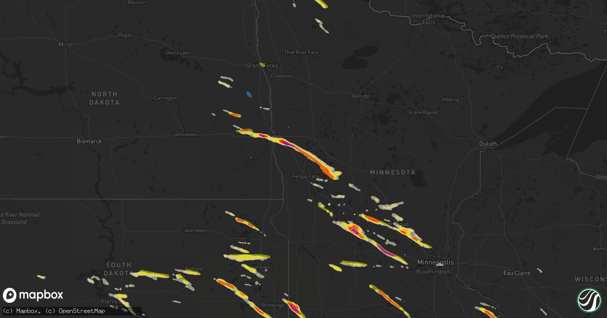
July 13 map
$229
one time, instant access
Download today. No call, no setup
Keep the $229
Bought the map and want the full workflow? Apply the entire $229 to a subscription within 7 days. None of it is wasted.
Every map, not just this one
This buys you this map. Subscription and you get every map we run, in the markets you choose from a few cities to whole states to nationwide. Plus real-time alerts the moment a storm fires.
Contact data
Name, contact info, occupancy, even credit band for addresses in the footprint. You go from where it hit to who to call.
Become the source they trust
Unlimited branding weather history reports on demand. You already have the documented answer ready for the property owner, and you are the one who showed up with it.
Property data and RoofTrace estimates
Pull up any address you have got, its value and the exact code rules for that jurisdiction, straight from One Click Code. Then RoofTrace estimates the squares, pitch, and roof value, priced the way you price.
States Impacted by Hail Map on July 13, 2023
- Missouri
- Nebraska
- Kansas
- Colorado
- West Virginia
- New York
- Iowa
- Minnesota
- Virginia
- Ohio
- North Dakota
- South Dakota
- Texas
- Vermont
- Oklahoma
- New Mexico
- Montana
- Wyoming
- South Carolina
- North Carolina
- Indiana
- Kentucky
- Florida
- Mississippi
- Arkansas
- Georgia
- Pennsylvania
- Wisconsin
- Illinois
- New Jersey
- New Hampshire
- Massachusetts
- Connecticut
- Michigan
Storm reports
Ohio
| Date | Description |
|---|---|
| 07/13/20236:31 PM CDT | Large tree down... Blocking cameron bridge road. |
| 07/13/20236:16 PM CDT | Tree down on mt. Hope road. |
| 07/13/20236:11 PM CDT | Tree down on west main street. |
| 07/13/20232:45 PM CDT | Tree down on hazel ridge road in clay township. |
| 07/13/20232:40 PM CDT | Tree down on rocky fork road in guyan township. |
| 07/13/20232:40 PM CDT | Tree down blocking one lane of state route 141 approximately a quarter mile south of zalmon lane. |
| 07/13/20232:20 PM CDT | Downed tree blocking both lanes of state route 141 near ford street. |
| 07/13/20231:21 PM CDT | Tree down on 125 near hamersville. Time estimated from radar. |
New Mexico
| Date | Description |
|---|---|
| 07/13/20236:50 PM CDT | Corrects previous non-tstm wnd gst report from 17 wnw oscuro. Mesonet station wsm39 shist |
| 07/13/202312:30 AM CDT | Long-lasting hail with strong winds and numerous tree branches downed. |
| 07/13/202312:00 AM CDT | Long-lasting hail and heavy rain. |
Colorado
| Date | Description |
|---|---|
| 07/13/20236:49 PM CDT | A local report indicates 2.75 inch wind near 9 SW Avondale |
| 07/13/20236:46 PM CDT | Car windshield was shattered. |
| 07/13/20236:38 PM CDT | A local report indicates 1.50 inch wind near 3 E Blende |
| 07/13/20236:33 PM CDT | A local report indicates 1.75 inch wind near 2 E Blende |
| 07/13/20236:24 PM CDT | Wfo pueblo office. |
| 07/13/20236:24 PM CDT | Pueblo memorial airport. Several cars have wind shields blown out. Window blown out in the building. |
| 07/13/20236:12 PM CDT | Report from mping: ping pong ball |
| 07/13/20236:04 PM CDT | A local report indicates 2.00 inch wind near 1 NW Stoneham |
| 07/13/20235:58 PM CDT | Damage to windows and several 6 to 8 inch diameter tree branches down west of stoneham. Time and location estimated. |
| 07/13/20235:56 PM CDT | Delayed report. Photo provided by a trained spotter showed hail as large as 3 to 3.5 inches in diameter... And this photo was taken roughly 2 hours after the hail fell. |
| 07/13/20235:54 PM CDT | Report from mping: quarter |
| 07/13/20235:52 PM CDT | A local report indicates 1.25 inch wind near 3 W Stoneham |
| 07/13/20235:30 PM CDT | A local report indicates 1.75 inch wind near 2 W Sheridan Lake |
| 07/13/20234:00 PM CDT | A local report indicates 2.20 inch wind near 6 E Karval |
| 07/13/20233:31 PM CDT | Corrects previous report. Currently 1-1.5 inch diameter hail falling. |
| 07/13/20233:13 PM CDT | A local report indicates 1.25 inch wind near 2 SSW Boyero |
| 07/13/20233:01 PM CDT | Time estimated. |
| 07/13/20233:01 PM CDT | Brief landspout tornado. Mostly condensed funnel extended to cloud base. |
| 07/13/20232:50 PM CDT | Public reported a lot of golf ball sized hail and not has heavy rain. |
| 07/13/20232:50 PM CDT | Mostly quarter sized hail... With a few estimated up to the size of ping pong. Also estimated up to 70 mph wind gusts. Time estimated by radar. |
| 07/13/20232:45 PM CDT | Estimated wind gust. Wind came approximately 5 minutes before hail at this location. |
| 07/13/20232:39 PM CDT | Public report of 1/4 to 3/4 inch average sized hail that began about 30-45 minutes ago. At the time of the report... A few baseball sized stones were falling. |
| 07/13/20231:23 PM CDT | A local report indicates 1.00 inch wind near Cope |
| 07/12/20238:47 PM CDT | Pole snapped. |
| 07/12/20238:44 PM CDT | Brief touchdown. Lasted 20 seconds. |
| 07/12/20238:16 PM CDT | Brief touchdown... Which lasted 30 seconds. |
| 07/12/20238:14 PM CDT | A local report indicates 1.00 inch wind near 1 NW Pueblo West |
| 07/12/20238:07 PM CDT | Power pole blown down cr w and 17. Time estimated by radar. |
| 07/12/20237:59 PM CDT | Barn roofs torn off... With most damage centered around county road 13... And aa and z. Time is estimated. |
| 07/12/20237:58 PM CDT | A local report indicates 1.00 inch wind near Pueblo West |
| 07/12/20237:57 PM CDT | Power pole blown down. Time estimated by radar. |
| 07/12/20237:47 PM CDT | Corrects previous tstm wnd dmg report from 2 ne pritchett. Pole snapped. |
South Dakota
| Date | Description |
|---|---|
| 07/13/20236:54 PM CDT | Report via social media. |
| 07/13/20236:03 PM CDT | Report from mping: quarter |
| 07/13/20235:49 PM CDT | Report from mping: quarter |
| 07/13/20235:36 PM CDT | Two power poles snapped along county road 15. |
| 07/13/20235:36 PM CDT | Wind driven hail broke out windows on buildings and homes... Crops and vegetation stripped bare. Hail accumulation of several inches blown into large piles. |
| 07/13/20235:36 PM CDT | A local report indicates 1.00 inch wind near 6 SW Batesland |
| 07/13/20235:35 PM CDT | A local report indicates 1.75 inch wind near 2 S Sinai |
| 07/13/20235:34 PM CDT | A local report indicates 87 MPH wind near 9 SW Batesland |
| 07/13/20235:22 PM CDT | Report from social media. Time estimated by radar. |
| 07/13/20235:21 PM CDT | A local report indicates 70 MPH wind near 5 WSW Batesland |
| 07/13/20235:21 PM CDT | A local report indicates 70 MPH wind near 5 WSW Batesland |
| 07/13/20235:21 PM CDT | Considerable crop damage and broken branches. Wind and hail lasted about 15 minutes. |
| 07/13/20235:15 PM CDT | A local report indicates 70 MPH wind near 2 NE Wounded Knee |
| 07/13/20235:15 PM CDT | A local report indicates 1.00 inch wind near 2 NE Wounded Knee |
| 07/13/20234:48 PM CDT | A local report indicates 1.50 inch wind near Erwin |
| 07/13/20234:35 PM CDT | Mesonet station onms2 onida 13wsw |
| 07/13/20234:34 PM CDT | Report from mping: quarter |
| 07/13/20234:30 PM CDT | A local report indicates 1.00 inch wind near Polo |
| 07/13/20234:25 PM CDT | Mostly dime... Up to quarter sized hail. Radar estimated time. |
| 07/13/20234:24 PM CDT | Dime to up as large as quarter sized hail... Along with strong winds. Radar estimated time. |
| 07/13/20234:19 PM CDT | Dime to quarter size hail caused significant damaged corn fields. |
| 07/13/20234:18 PM CDT | Radar estimated time. |
| 07/13/20234:15 PM CDT | Corrects previous hail report from 8 ese rosseau. Observer corrected report to 0.72 inches of rain and 55 mph winds. Tree limbs 4 inches in diameter broken. |
| 07/13/20234:15 PM CDT | Delayed report. |
| 07/13/20234:13 PM CDT | Radar estimated time. |
| 07/13/20234:08 PM CDT | Hail up to quarter size. |
| 07/13/20234:08 PM CDT | Hail covering the ground with no gravel visible on roads... Up to 3 inches deep in some spots. Mostly quarter sized hailstones... With a few larger. |
| 07/13/20234:08 PM CDT | Mesonet station 215 jct sd47/sd26 |
| 07/13/20234:02 PM CDT | A local report indicates 1.00 inch wind near 2 S Redfield |
| 07/13/20233:58 PM CDT | Quarter to half dollar size hail in florence. |
| 07/13/20233:48 PM CDT | Corrects time of the previous hail report from 2 n pickerel lake station. Radar estimated time. |
| 07/13/20233:32 PM CDT | A local report indicates 1.75 inch wind near 1 S Fort Sisseton State |
| 07/13/20233:22 PM CDT | Hail nearly covering the ground... Some larger than quarters. Radar estimated time. |
| 07/13/20232:48 PM CDT | Radar estimated time. |
Florida
| Date | Description |
|---|---|
| 07/13/20236:53 PM CDT | Asos station kpbi west palm beach reports a wind gust of 67 mph during a strong thunderstorm. |
Kentucky
| Date | Description |
|---|---|
| 07/13/20233:35 PM CDT | Tree fell onto house and powerlines along state route 207 near baker cemetery road. |
Montana
| Date | Description |
|---|---|
| 07/13/20236:12 PM CDT | Recorded at the jordan airport asos. |
| 07/12/20237:50 PM CDT | An old building wall structure fell during the passage of an outflow boundary and the associated thunderstorm. |
Minnesota
| Date | Description |
|---|---|
| 07/13/20236:57 PM CDT | Report via social media. Time estimated by radar. |
| 07/13/20236:57 PM CDT | A local report indicates 1.75 inch wind near Jasper |
| 07/13/20236:51 PM CDT | A local report indicates 1.75 inch wind near Albany |
| 07/13/20236:46 PM CDT | Report from mping: ping pong ball |
| 07/13/20236:45 PM CDT | A local report indicates 1.75 inch wind near Freeport |
| 07/13/20236:41 PM CDT | Report from mping: quarter |
| 07/13/20236:35 PM CDT | Report from mping: half dollar |
| 07/13/20236:34 PM CDT | Pea to quarter sized hail. |
| 07/13/20236:33 PM CDT | A local report indicates 1.25 inch wind near Roseau |
| 07/13/20236:30 PM CDT | Late lsr - cocorahs observer measured golf ball sized hail 2 miles w of new sweden... Mn. Time estimated using radar. |
| 07/13/20236:29 PM CDT | Corrects previous hail report from roseau. |
| 07/13/20236:29 PM CDT | Trees uprooted or snapped; roof blown off. |
| 07/13/20236:27 PM CDT | 1 inch hail reported in roseau via twitter. Time estimated via radar. |
| 07/13/20236:26 PM CDT | Also 45 to 50 mph winds. |
| 07/13/20236:25 PM CDT | 1.5-1.75 inch hail. |
| 07/13/20236:24 PM CDT | Report from mping: quarter |
| 07/13/20236:24 PM CDT | A local report indicates 1.00 inch wind near 5 W Ruthton |
| 07/13/20236:15 PM CDT | Personal weather station. |
| 07/13/20236:12 PM CDT | Report via social media. |
| 07/13/20236:12 PM CDT | A local report indicates 1.25 inch wind near Lake Benton |
| 07/13/20236:11 PM CDT | Delayed report. Picture report via social media. |
| 07/13/20236:10 PM CDT | A local report indicates 2.75 inch wind near Belgrade |
| 07/13/20236:10 PM CDT | A local report indicates 1.75 inch wind near Belgrade |
| 07/13/20236:10 PM CDT | Correction to previous lsr based on photo evidence. |
| 07/13/20236:05 PM CDT | Dime to quarter size hail. |
| 07/13/20235:45 PM CDT | 8-10 inch tree branch broken. |
| 07/13/20235:35 PM CDT | Hailed for 15-20 minutes. |
| 07/13/20234:55 PM CDT | A local report indicates 2.00 inch wind near 3 NNW Downer |
| 07/13/20234:52 PM CDT | Property damage with multiple hail pictures suggesting 3 inches or larger possible based on visual estimates. |
| 07/13/20233:20 PM CDT | A local report indicates 1.00 inch wind near East Grand Forks |
| 07/13/20233:16 PM CDT | A local report indicates 1.00 inch wind near East Grand Forks |
| 07/13/202311:30 AM CDT | Relayed by social media. |
| 07/13/202312:29 AM CDT | Relayed by emergency management. |
| 07/13/202312:20 AM CDT | A local report indicates 1.00 inch wind near 2 W Ridgeway |
| 07/13/202312:19 AM CDT | Relayed by emergency management. |
| 07/12/202311:30 PM CDT | A local report indicates 1.50 inch wind near 4 SSE Theilman |
| 07/12/202311:27 PM CDT | A local report indicates 1.50 inch wind near 3 NNE Plainview |
| 07/12/20239:53 PM CDT | Asos station kmsp minneapolis-st. Paul ap. |
| 07/12/20238:44 PM CDT | Nickel to quarter sized. |
| 07/12/20238:27 PM CDT | Report from mping: ping pong ball |
| 07/12/20238:15 PM CDT | Delayed report from social media. |
| 07/12/20237:54 PM CDT | A local report indicates 2.75 inch wind near 5 ENE Ellsworth |
| 07/12/20237:52 PM CDT | A local report indicates 1.75 inch wind near 1 ESE Clear Lake |
| 07/12/20237:50 PM CDT | Report from mping: tennis ball |
| 07/12/20237:40 PM CDT | - late lsr - emergency managment reported quarter size hail in the city of cokato... Mn. Time is approximated via radar. |
| 07/12/20237:40 PM CDT | Report from mping: ping pong ball |
| 07/12/20237:40 PM CDT | A local report indicates 2.50 inch wind near Magnolia |
| 07/12/20237:39 PM CDT | Reports of trees down. |
| 07/12/20237:35 PM CDT | A local report indicates 1.00 inch wind near 2 SSW Janesville |
| 07/12/20237:35 PM CDT | Email report. |
| 07/12/20237:35 PM CDT | Reported by minnesota dot weather station. Time corrected by radar. |
| 07/12/20237:34 PM CDT | Measured by personal weather station. |
| 07/12/20237:30 PM CDT | Late lsr - golf ball sized hail 2 miles north of dassel... Mn via social media. Time estimated by radar. |
| 07/12/20237:24 PM CDT | Report from mping: half dollar |
| 07/12/20237:22 PM CDT | A local report indicates 1.00 inch wind near 1 ESE St. Joseph |
| 07/12/20237:10 PM CDT | A local report indicates 1.00 inch wind near Lowry |
| 07/12/20237:05 PM CDT | Report from mping: quarter |
North Carolina
| Date | Description |
|---|---|
| 07/13/20232:30 PM CDT | The mt. Airy fire chief reported that up to 25 large trees were down along the 1300 block of main street in mt. Airy. Considerable damage to trees and property as a res |
| 07/12/20239:30 PM CDT | Multiple trees down across cleveland county. |
| 07/12/20237:50 PM CDT | Multiple trees down near glenn faust rd. |
| 07/12/20237:40 PM CDT | Trees down near foster rd and cool springs rd. |
| 07/12/20237:25 PM CDT | Large tree down in driveway on sherrills ford rd. |
| 07/12/20237:24 PM CDT | Trees down on powerlines near jones rd and centenary rd. |
| 07/12/20237:10 PM CDT | Powerlines down in driveway. |
Iowa
| Date | Description |
|---|---|
| 07/13/20236:20 PM CDT | 1 inch branches down from wind. |
| 07/13/20233:02 PM CDT | Report from mping: quarter |
| 07/13/20232:52 PM CDT | Nickel to quarter sized hail. Relayed by law enforcement. |
| 07/12/202310:53 PM CDT | A local report indicates 1.00 inch wind near Oelwein |
| 07/12/20238:54 PM CDT | A local report indicates 1.00 inch wind near 2 W Gilman |
| 07/12/20238:52 PM CDT | A local report indicates 1.50 inch wind near 1 N Hartley |
| 07/12/20238:31 PM CDT | Low hanging wall cloud also observed. |
| 07/12/20238:27 PM CDT | Report from mping: quarter |
| 07/12/20238:26 PM CDT | A local report indicates 1.00 inch wind near 1 WSW Marshalltown |
| 07/12/20238:24 PM CDT | A local report indicates 62 MPH wind near 1 W Sibley |
| 07/12/20238:23 PM CDT | A local report indicates 72 MPH wind near Marshalltown |
| 07/12/20238:20 PM CDT | Corrects previous tstm wnd gst report from 1 w sibley. |
| 07/12/20238:18 PM CDT | Delayed report. |
| 07/12/20238:15 PM CDT | A local report indicates 1.00 inch wind near 1 ESE Albion |
New York
| Date | Description |
|---|---|
| 07/13/20236:59 PM CDT | Trees downed across forest prserve road |
| 07/13/20236:59 PM CDT | Trees down |
| 07/13/20236:57 PM CDT | Trees down at multiple locations in chatham per 911 dispatch |
| 07/13/20236:57 PM CDT | Trees down |
| 07/13/20236:53 PM CDT | Numerous trees down in town of ghent per law enforement. |
| 07/13/20236:45 PM CDT | A local report indicates 1.00 inch wind near Germantown |
| 07/13/20236:43 PM CDT | *** 1 inj *** tree down on occupied vehicle. 1 minor injury |
| 07/13/20236:43 PM CDT | *** 1 inj *** tree down on occupied vehicle. 1 minor injury |
| 07/13/20236:32 PM CDT | Tree down on house |
| 07/13/20236:27 PM CDT | Trees down across route 9g |
| 07/13/20236:24 PM CDT | Route 9w closed at division stdue to downed trees |
| 07/13/20236:22 PM CDT | Tree... Pole and wires downed across county route 61 |
| 07/13/20236:15 PM CDT | Trees and wires downed across county route 49 |
| 07/13/20235:55 PM CDT | Multiple trees and wires down on route 9. |
| 07/13/20235:55 PM CDT | Tree downed across state route 4 |
| 07/13/20235:50 PM CDT | 60 mph wind gust measured at columbia county airport. Multiple 2 inch tree limbs down |
| 07/13/20235:44 PM CDT | Tree downed across hunt ave |
| 07/13/20235:38 PM CDT | Porch damage on a house on franklin st |
| 07/13/20235:36 PM CDT | Multiple trees and wires down across the county. 911 dispatch too busy to talk |
| 07/13/20235:35 PM CDT | A local report indicates 1.00 inch wind near Waverly |
| 07/13/20235:32 PM CDT | Tree down on wires... Partially blocking the road. |
| 07/13/20235:22 PM CDT | Multiple trees downed across pattens mills road |
| 07/13/20235:18 PM CDT | Tree and wires down at route 32 and callahan rd |
| 07/13/20235:18 PM CDT | Tree downed on route 20 |
| 07/13/20235:18 PM CDT | Tree downe |
| 07/13/20235:17 PM CDT | Tree and wires down |
| 07/13/20235:15 PM CDT | Wires down on charleston st. |
| 07/13/20235:15 PM CDT | Trees down on creek side road. |
| 07/13/20235:13 PM CDT | Tree and wires down |
| 07/13/20235:13 PM CDT | Multiple trees and wires down across greenfield |
| 07/13/20235:13 PM CDT | Tree downed across pike brook road |
| 07/13/20235:10 PM CDT | Tree and wires across route 9 at hudson st. |
| 07/13/20235:10 PM CDT | Tree down blocking walnut st. |
| 07/13/20235:05 PM CDT | Trees and wires down on route 20 and 30a. |
| 07/13/20235:04 PM CDT | Many trees and powerlines across the city. Streets are impassable in places. |
| 07/13/20235:02 PM CDT | Tree and wires down |
| 07/13/20235:02 PM CDT | Tree on wires with transformer on fire. |
| 07/13/20235:00 PM CDT | Tree downed across county route 2 |
| 07/13/20234:53 PM CDT | Tree down over upper dutch hill road. |
| 07/13/20234:52 PM CDT | Wires down blocking state route 9n. |
| 07/13/20234:45 PM CDT | Trees down on arnold lake road off of county rt 46. |
| 07/13/20234:42 PM CDT | Corrects previous tstm wnd dmg report from schenevus. Corrects previous tstm wnd dmg report from schenevus. Tree down on house. |
| 07/13/20234:42 PM CDT | Frontier campground reported quarter size hail. Time estimated from radar. |
| 07/13/20234:39 PM CDT | Tree and wire down near intersection of clinton rd and rte 163. |
| 07/13/20234:30 PM CDT | Several trees and powerlines down |
| 07/13/20234:27 PM CDT | Paradox lake campground reported hail ranging from dime to quarter size. |
| 07/13/20234:23 PM CDT | Tree down on wires at 360 brady road... Exeter ny. |
| 07/13/20234:23 PM CDT | Multiple trees and wires down across southern and eastern fulton county per 911 dispatch |
| 07/13/20234:21 PM CDT | Large tree down blocking road at 544 angel hill road... Exeter ny. |
| 07/13/20234:15 PM CDT | Corrects previous tstm wnd dmg report from 1 sse mt vision. Tree down over upper dutch hill road. |
| 07/13/20234:15 PM CDT | Corrects previ |
| 07/13/20234:12 PM CDT | Local utility company reported a tree down in cannon corners |
| 07/13/20234:10 PM CDT | Corrects previous tstm wnd dmg report from 3 se hartwick. Trees down on arnold lake road off of county rt 46. |
| 07/13/20234:07 PM CDT | Frontier campground reported quarter size hail. Time estimated from radar. |
| 07/13/20234:05 PM CDT | Tree blocking west bound lane of route 5. |
| 07/13/20233:47 PM CDT | Corrects previous tstm wnd dmg report from schenevus. Tree down on house. |
| 07/13/20233:42 PM CDT | One tree down |
| 07/13/20233:41 PM CDT | Tree down blocking road. |
| 07/13/20233:40 PM CDT | Small branches down |
| 07/13/20233:35 PM CDT | Corrects previous tstm wnd dmg report from exeter center. Large tree down blocking road at 544 angel hill road... Exeter ny. |
| 07/13/20233:33 PM CDT | Small branches also falling at time of call |
| 07/13/20233:26 PM CDT | Essex county sheriff's office reported a tree down in schroon lake. |
| 07/13/20233:25 PM CDT | One tree down |
| 07/13/20233:23 PM CDT | Corrects previous tstm wnd dmg report from 1 sw exeter center. Tree down on wires at 360 brady road... Exeter ny. |
| 07/13/20233:23 PM CDT | The essex county sheriff's office reported a tree down on a powerline near newcomb... Causing a small wildland fire. |
| 07/13/20233:15 PM CDT | Tree on the wires on bleck road near babcock hollow road. |
| 07/13/20233:00 PM CDT | Numerous trees and wires down in both the towns of russia and ohio. |
| 07/13/20232:58 PM CDT | Trees down on wires on 118 ridge road... Utica ny. |
| 07/13/20232:54 PM CDT | Wires down on sleepy hollow road in rome... Ny. |
| 07/13/20232:52 PM CDT | Corrects previous tstm wnd dmg report from 4 s virgil. Tree on the wires on bleck road near babcock hollow road. |
| 07/13/20232:40 PM CDT | A local report indicates 1.00 inch wind near 1 NE Brant Lake |
| 07/13/20232:40 PM CDT | A local report indicates 1.25 inch wind near 2 ENE Brant Lake |
| 07/13/20232:28 PM CDT | Lincoln pond campground reported hail up to the size of a quarter. |
| 07/13/20232:23 PM CDT | Tree down on electrical pole. |
| 07/13/20232:17 PM CDT | Trees and wires down on river rd. |
| 07/13/20232:16 PM CDT | Corrects previous tstm wnd dmg report from 1 w delta lake. Wires down on sleepy hollow road in rome... Ny. |
| 07/13/20232:15 PM CDT | Trees down on power poles. Relayed by oneida county. |
| 07/13/20232:13 PM CDT | Trees down on electrical pole on strong road... Tully... Ny. |
| 07/13/20232:06 PM CDT | Corrects previous tstm wnd dmg report from 1 w lyncourt. Reported tent blew into power lines on court street... Syracuse... Ny. |
| 07/13/20232:04 PM CDT | Trees and wires down in the town of watson. |
| 07/13/20232:03 PM CDT | Trees and wires down on rt 177. |
| 07/13/20232:03 PM CDT | Trees and wires down on park ave. |
| 07/13/20232:03 PM CDT | Trees and wires down at west rd and gardner rd. |
| 07/13/20232:01 PM CDT | North hudson campground estimated half dollar size hail. |
| 07/13/20231:50 PM CDT | Trees down over bradbury road. |
| 07/13/20231:45 PM CDT | Tree down across henry clay blvd. Time estimated by radar. |
| 07/13/20231:41 PM CDT | Corrects previous tstm wnd dmg report from 3 n camden. Tree down on electrical pole. |
| 07/13/20231:36 PM CDT | Trees and wires down. |
| 07/13/20231:33 PM CDT | Sumac trees blown down. |
| 07/13/20231:20 PM CDT | Large tree fell across davis road just south of 326. A vehicle hit the tree... But no injuries reported. |
| 07/13/20231:20 PM CDT | Local police reported multiple trees down on the roadway. |
| 07/13/20231:16 PM CDT | Trees and wires down. |
| 07/13/20231:13 PM CDT | Tree fell on a house on goodwin st. Time estimated from radar. |
| 07/13/20231:11 PM CDT | Trees and wires down. |
| 07/13/20231:06 PM CDT | Trees and wires down. |
| 07/13/202312:42 PM CDT | Tree down over roadway. |
| 07/13/202312:38 PM CDT | Tree down over roadway. |
| 07/12/202311:16 PM CDT | Tree down and road closure on us 202 both directions at lovell st. |
| 07/12/20237:57 PM CDT | Tree down on wires on mcmullen road. |
| 07/12/20237:57 PM CDT | Tree down on wires near jacobs road and route 1. |
| 07/12/20237:55 PM CDT | Trees downed at the intersection of state route 199 and orlich road. Ny route 199 was closed to traffic. |
| 07/12/20237:27 PM CDT | Tree down |
| 07/12/20237:00 PM CDT | Road closure due to downed tree on north and south ny-9g at old road in the town of clermont in columbia county |
Indiana
| Date | Description |
|---|---|
| 07/13/20231:28 PM CDT | Report from mping: quarter |
Texas
| Date | Description |
|---|---|
| 07/13/20236:40 PM CDT | A local report indicates 58 MPH wind near 2 SE Truscott |
| 07/13/20236:31 PM CDT | A local report indicates 63 MPH wind near Sheppard Afb |
| 07/13/20236:15 PM CDT | Corrects time from previous tstm wnd dmg report from 1 nw vernon. Large section of metal roof facade removed. Time estimated via radar. |
| 07/13/20235:15 PM CDT | Large section of metal roof facade removed. Time estimated via radar. |
| 07/13/20234:40 PM CDT | A local report indicates 1.25 inch wind near 7 SSE Vega |
| 07/13/20234:15 PM CDT | A local report indicates 72 MPH wind near Crowell |
| 07/13/20234:05 PM CDT | A local report indicates 1.00 inch wind near Crowell |
| 07/13/20233:34 AM CDT | Observed by west texas mesonet. |
| 07/13/20233:25 AM CDT | Observed by borger asos. |
| 07/13/20231:52 AM CDT | Observed by dalhart asos. |
| 07/13/20231:03 AM CDT | Observed by west texas mesonet. |
| 07/13/202312:41 AM CDT | Asos station kcds childress municipal airport. Also recorded a 64 mph gust at 1242 am. |
| 07/13/202312:40 AM CDT | West texas mesonet. Also recorded a gust to 64 mph at 1239 am. |
| 07/13/202312:30 AM CDT | Asos station kcds childress municipal airport. |
| 07/13/202312:22 AM CDT | West texas mesonet. |
| 07/12/202311:31 PM CDT | West texas mesonet. Other severe gusts ranging from 65 to 70 mph recorded until 1135 pm. |
| 07/12/20239:32 PM CDT | West texas mesonet report. |
| 07/12/20239:32 PM CDT | West texas mesonet report |
| 07/12/20238:57 PM CDT | Report from texline fire department chief of golf ball size hail with a few baseballs mixed in. Time estimated by radar. |
| 07/12/20238:52 PM CDT | Observed by west texas mesonet. |
| 07/12/20238:52 PM CDT | Observed by west texas mesonet. |
| 07/12/20238:32 PM CDT | West texas mesonet report |
| 07/12/20238:32 PM CDT | West texas mesonet report. |
Arkansas
| Date | Description |
|---|---|
| 07/13/20234:05 AM CDT | Nws tulsa storm survey has reported ef1 tornado damage on the south side of mansfield. Additional information still to be determined. Time is radar estimated. |
| 07/13/20234:00 AM CDT | Part of a tree fell through the roof of a home. Time is radar estimated. Reported relayed through broadcast media via social media. |
| 07/13/20233:49 AM CDT | Tree uprooted onto a house in fort smith. Time estimated based on messured gust at kfsm. Reported relayed via social media. |
| 07/13/20233:49 AM CDT | Measured at kfsm asos observation site. |
| 07/13/20233:40 AM CDT | Corrects previous tstm wnd dmg report from fort smith. Tree uprooted onto a house in fort smith. Time estimated based on messured gust at kfsm. Reported relayed via soc |
| 07/13/20233:40 AM CDT | Several trees down between bonanza and hackett. Time estimated by radar. |
| 07/13/20233:36 AM CDT | A local report indicates 70 MPH wind near 3 E Mill Creek |
Vermont
| Date | Description |
|---|---|
| 07/13/20236:58 PM CDT | Trees and powerlines down. Time estimated from radar. |
| 07/13/20236:50 PM CDT | Trees and powerlines down. |
| 07/13/20236:40 PM CDT | Numerous trees down near the intersection of route 11 and lovers lane |
| 07/13/20236:35 PM CDT | Trees and powerlines down. Time estimated from radar |
| 07/13/20236:16 PM CDT | Trees and powerlines down. |
| 07/13/20236:13 PM CDT | Trees and powerlines down |
| 07/13/20236:13 PM CDT | Several trees were reported down by the lamoille county sheriff's office |
| 07/13/20236:08 PM CDT | Several trees were reported down in the waitsfield area |
| 07/13/20236:02 PM CDT | Trees and powerlines down. |
| 07/13/20236:00 PM CDT | Numerous trees and powerlines down. Time estimated |
| 07/13/20235:55 PM CDT | Power lines were reported down by the lamoille county sheriff's office |
| 07/13/20235:43 PM CDT | Trees down in wires closing portion of vt-73. Time is radar estimated |
| 07/13/20235:30 PM CDT | The rutland county sheriff office reported numerous trees and powerlines down across northwest rutland county. Some of the damage is blocking roadways. |
| 07/13/20235:21 PM CDT | Tree and powerline damage occurred on hortonia road just south of sudbury... Vt with downed trees in different directions. A nws storm survey team confirmed an ef-0 tor |
| 07/13/20235:15 PM CDT | Numerous trees and powerlines were down in multiple directions near benson... Vt. A nws storm survey team confirmed an ef-0 tornado with peak winds of 85 mph. |
| 07/13/20235:02 PM CDT | Trees and powerlines down. |
| 07/13/20235:02 PM CDT | Numerous power lines down. Time estimated from radar |
| 07/13/20235:00 PM CDT | Measured by a cwop. |
| 07/13/20234:56 PM CDT | Trees reported down in five tree hill country park. |
| 07/13/20234:45 PM CDT | Spotter reported a large tree limb down |
| 07/13/20234:36 PM CDT | *** 1 inj *** a nws storm survey has confirmed a microburst occurred near shoreham... Vt with estimated maximum winds of 85 mph. Between 50 and 75 large trees were foun |
| 07/13/20234:34 PM CDT | Several trees down... And some snapped at the top. |
| 07/12/20237:22 PM CDT | Tree down with power lines along vt 346 south of church street in pownal. Time estimated by radar. |
| 07/12/20237:14 PM CDT | Damage to house siding |
| 07/12/20237:05 PM CDT | Powerlines and trees down. Time estimated from radar. |
| 07/12/20237:05 PM CDT | Powerlines and trees down |
| 07/12/20237:00 PM CDT | Damage to house siding |
Oklahoma
| Date | Description |
|---|---|
| 07/13/20236:40 PM CDT | Power pole snapped. Time and location are estimated. |
| 07/13/20236:15 PM CDT | Relayed via twitter. |
| 07/13/20236:15 PM CDT | Relayed via twitter. |
| 07/13/20236:00 PM CDT | A local report indicates 60 MPH wind near 2 N Hollister |
| 07/13/20233:30 AM CDT | Windows blown out of a dollar general store with at least some structural damage to the front of the building. |
| 07/12/20239:47 PM CDT | Report from emergency manager of an unknown number of downed power lines on east-west 21 between north-south 30 and 36. Time estimated from radar. |
| 07/12/20239:47 PM CDT | 2 power poles/lines down. Time estimated from radar. |
| 07/12/20239:45 PM CDT | Observed by oklahoma mesonet. |
| 07/12/20239:35 PM CDT | Power poles damaged. Time estimated via radar. |
| 07/12/20237:30 PM CDT | 6 power poles down on se 45th and lee in lawton. |
| 07/12/20237:30 PM CDT | Corrects previous report from 3 ese lawton. 6 power poles down on se 45th and lee in lawton. |
| 07/12/20237:26 PM CDT | Report from mping. |
Mississippi
| Date | Description |
|---|---|
| 07/13/202311:29 AM CDT | An canopy was blown off a gas station at ms 19 and rd 561. |
| 07/13/202310:26 AM CDT | A portion of the roof of an outbuilding was blown off. |
Connecticut
| Date | Description |
|---|---|
| 07/12/202311:49 PM CDT | Tree down on west redding road blocking one lane of traffic. |
New Hampshire
| Date | Description |
|---|---|
| 07/12/20238:45 PM CDT | Delayed report. Downed trees also reported in the area. |
| 07/12/20238:30 PM CDT | Trees down on nh-123. |
| 07/12/20238:25 PM CDT | Tree down partially blocking nh rt. 10. |
| 07/12/20238:20 PM CDT | Several large branches and 2 12-inch diameter trees down on nh rt. 78. |
| 07/12/20238:15 PM CDT | Photos sent via social media of hail stones with some quarter size. |
| 07/12/20238:10 PM CDT | Trees down across river rd. |
| 07/12/20238:05 PM CDT | Hail fell for 5 mins in the area of spaulding hill rd and highway 9. |
| 07/12/20238:00 PM CDT | Delayed report. Downed trees on river rd. |
| 07/12/20238:00 PM CDT | Delayed report. Tree down at local hotel. |
| 07/12/20237:40 PM CDT | Tree and power lines down across dalton rd. |
| 07/12/20237:30 PM CDT | Delayed report. Trees down in plainfield. One tree partially blocking stage rd. |
| 07/12/20237:30 PM CDT | Tree down across main st. In the area of parker rd. |
| 07/12/20237:29 PM CDT | Trees down on jarvis hill rd. |
| 07/12/20237:20 PM CDT | Tree down across river rd. |
| 07/12/20237:20 PM CDT | Delayed report. Trees down north of haverhill. |
West Virginia
| Date | Description |
|---|---|
| 07/13/20236:55 PM CDT | Two trees down in ronceverte. |
| 07/13/20236:45 PM CDT | Power lines blown down on 2nd street |
| 07/13/20236:31 PM CDT | Corrected report. Large tree down... Blocking cameron bridge road. |
| 07/13/20236:30 PM CDT | Numerous calls reporting downed trees in the county. Time estimated. |
| 07/13/20236:20 PM CDT | One tree down in crawley. |
| 07/13/20236:15 PM CDT | One tree down in rupert. |
| 07/13/20236:04 PM CDT | Report of trees down along goshorn woods road. Time estimated based on radar. |
| 07/13/20236:02 PM CDT | Report of trees down on new bethel road. Time estimated based on radar. |
| 07/13/20234:40 PM CDT | Trees down in cedar grove and hugheston. |
| 07/13/20234:30 PM CDT | Large tree fell and is blocking all lanes of washington street e near abundant life church. |
| 07/13/20234:30 PM CDT | Large tree fell and is blocking all lanes of washington street e near abundant life church. Additional trees down in the area on bendview dr. |
| 07/13/20234:15 PM CDT | Tree down on w union rd and thorofare rd. Tree contact also caused power outage to 13 customers in the area. |
| 07/13/20233:30 PM CDT | Storm knocked out power to around 1000 customers from winfield to poca. |
| 07/13/20233:25 PM CDT | Tree down blocking half winfield road at the winfield church of christ. |
| 07/13/20233:25 PM CDT | Tree down on mclane pike at lime kiln road. |
| 07/13/20233:25 PM CDT | Tree down along mclane pike at lone oak road. |
| 07/13/20233:20 PM CDT | Tree down along winfield road near winfield mobile home village drive. |
| 07/13/20233:15 PM CDT | Tree down on winfield road at tuckers branch road. |
| 07/13/20233:10 PM CDT | Tree down on power lines near hunt lane. |
| 07/13/20233:00 PM CDT | Tree down on ashton upland road. |
| 07/13/20232:55 PM CDT | Several small trees and one large tree down along jerico road. |
| 07/13/20232:55 PM CDT | Several small trees and one large tree down al |
| 07/13/20232:05 PM CDT | Several trees down in the community. |
| 07/13/20231:43 PM CDT | Corrects previous non-tstm wnd dmg report from birch river. Fallen tree and downed lines reported in birch river. Time estimated from radar. |
| 07/13/20231:35 PM CDT | Several trees reported down on wilsons ridge road. |
| 07/13/20231:30 PM CDT | Large branch knocked out of sycamore tree at camp virgil tate. |
| 07/13/20231:25 PM CDT | Storm caused approximately 200 customers to lose power in separate areas betwe) |
| 07/13/20231:25 PM CDT | Storm caused approximately 200 customers to lose power in separate areas between winfield and sissonville. |
| 07/12/202311:29 PM CDT | In algoma at the church there is a tree blocking the road. |
| 07/12/202310:43 PM CDT | Trees down just before safe house. |
New Jersey
| Date | Description |
|---|---|
| 07/13/20236:15 AM CDT | Report of tree damage on south street in morristown. Time estimated via radar. |
| 07/13/20236:00 AM CDT | Downed tree on us 206 southbound north of nj 24/cr 513/west main st |
| 07/13/20235:57 AM CDT | Trees down in bernards township. Time estimated via radar. |
| 07/13/20235:42 AM CDT | Trees down in hillsborough township. Time estimated via radar. |
| 07/13/20235:20 AM CDT | Trees down in east amwell township. Time estimated via radar. |
| 07/13/20235:20 AM CDT | Trees and wires down on hopewell wertsville road. Time estimated via radar. |
| 07/12/20239:30 PM CDT | Public report via social media; quarter-sized hail occurred between 10:18 and 10:30 pm. |
| 07/12/20237:13 PM CDT | Tree down on phillips lane. |
Pennsylvania
| Date | Description |
|---|---|
| 07/13/20236:57 PM CDT | Mostly pea to nickel size with largest hail around quarter size. Time estimated based on radar. |
| 07/13/20236:55 PM CDT | Tree down on south forge road. |
| 07/13/20236:54 PM CDT | Report of trees down in the area. Time estimated based on radar. |
| 07/13/20236:54 PM CDT | A local report indicates 1.00 inch wind near Taylorstown |
| 07/13/20236:53 PM CDT | A local report indicates 1.00 inch wind near West Alexander |
| 07/13/20236:42 PM CDT | Trees down across roadway on state route 92n near oakland. |
| 07/13/20236:08 PM CDT | Along route 402. Radar-estimated time. Reported to nws via social media. |
| 07/13/20235:57 PM CDT | Tree down on wires on kimbles rd. |
| 07/13/20235:34 PM CDT | Sent in via social media with picture. Radar-estimated time. |
| 07/12/202311:07 PM CDT | Trees down on renovo rd in grugan twp. Time estimated by radar. |
| 07/12/202311:00 PM CDT | Tree on power lines on farrandsville rd. Time estimated by radar. |
| 07/12/202310:57 PM CDT | Trees on power lines. Time estimated by radar. |
| 07/12/20239:58 PM CDT | Tree down on coal hill road near riverview road. |
| 07/12/20239:45 PM CDT | Tree down on curwensville grampian highway. |
| 07/12/20239:44 PM CDT | Multiple trees and wires down. |
| 07/12/20239:41 PM CDT | Multiple trees down. |
| 07/12/20239:35 PM CDT | Tree down blocking whiskey run road at colonel drake highway. |
| 07/12/20239:26 PM CDT | Tree down across twin lakes road at don drive intersection. Reported to nws via social media. Radar-estimated time from main core of storm. |
| 07/12/20239:24 PM CDT | A tree was reported down over the intersection of ridge road and cloe rossier road. |
| 07/12/20238:50 PM CDT | A tree was reported down along route 403 in kenwood pa in indiana county. |
| 07/12/20238:44 PM CDT | Tree down on twin lake rd near rt 6. |
| 07/12/20238:38 PM CDT | A tree limb greater than 3 inch diameter was reported down on old route 119. |
| 07/12/20238:30 PM CDT | Trees down along route 286. Time estimated. |
| 07/12/20238:30 PM CDT | Tree down on old route 56. Time estimated. |
| 07/12/20238:10 PM CDT | Report and photo of trees snapped in half in bell township. Additional report of damage to outdoor window shutters and roof vent pulled up. Time estimated based on rada |
| 07/12/20238:07 PM CDT | Quarter to ping pong ball size hail reported in delaware township. |
| 07/12/20238:05 PM CDT | Report from mping: half dollar |
| 07/12/20237:53 PM CDT | Numerous trees down in upper burrell township. Time estimated. |
| 07/12/20237:50 PM CDT | Numerous trees down in the area. Time estimated. |
| 07/12/20237:45 PM CDT | Tree down on railroad. Time estimated. |
| 07/12/20237:42 PM CDT | Report and photo showing multiple trees down in penn hills area. Time estimated based on radar. |
| 07/12/20237:40 PM CDT | Tree down at intersection of gross street and mond way. Time estimated. |
| 07/12/20237:37 PM CDT | Photo showing large tree down. Time estimated based on radar. |
| 07/12/20237:36 PM CDT | Report of tree down on car outside west penn hospital. Time estimated based on radar. |
| 07/12/20237:35 PM CDT | Large tree down on road near intersection of gross street and friendship avenue. Time estimated. |
| 07/12/20237:34 PM CDT | Report of large tree limbs down on power lines in squirrel hill north. Time estimated based on radar. |
| 07/12/20237:24 PM CDT | Report and photo of several large tree limbs snapped and medium size trees down. Time estimated based on radar. |
| 07/12/20237:24 PM CDT | Photo showing large tree on roadway that was snapped in half. Time estimated based on radar. |
| 07/12/20237:21 PM CDT | Report from mping: 3-inch tree limbs broken; power poles broken. |
| 07/12/20237:20 PM CDT | Large branches torn off of a tree. Picture provided. Time estimated. |
| 07/12/20237:20 PM CDT | Tree down on car at the intersection of abbey lane and ridgebury drive. No injuries. Time estimated. |
| 07/12/20237:18 PM CDT | Measured on home weather station in north fayette township. Time estimated. |
| 07/12/20237:18 PM CDT | Tree blown down at the corner of pleasant and high steet. Time estimated based on radar. |
| 07/12/20237:14 PM CDT | A local report indicates 1.00 inch wind near 3 ESE Lebanon |
| 07/12/20237:12 PM CDT | Trees down on morgan hill road. Time estimated. |
| 07/12/20237:12 PM CDT | Photo showing large tree snapped near trunk. Time estimated based on radar. |
| 07/12/20237:08 PM CDT | Trees down over twin rocks road near creamery road. |
| 07/12/20237:07 PM CDT | A tree was reported down on powerlines on dickerson run road. |
| 07/12/20237:05 PM CDT | Report of tree blown down. Time estimated based on radar. |
| 07/12/20237:05 PM CDT | Located off of mcclay road. |
| 07/12/20237:00 PM CDT | Trees down on belgium hill road. Time estimated. |
Nebraska
| Date | Description |
|---|---|
| 07/13/20236:34 PM CDT | A local report indicates 60 MPH wind near 9 S Oshkosh |
| 07/13/20236:30 PM CDT | Coop observer reports numerous power poles down 8 miles north northeast of oshkosh. Winds estimated at 60 to 70 mph. |
| 07/13/20236:30 PM CDT | Coop observer reports 11 power poles down 8 miles north northeast of oshkosh along road 189 between roads 64 and 70. Winds estimated at 70 - 80 mph. |
| 07/13/20236:15 PM CDT | A local report indicates 1.00 inch wind near 12 SW Merriman |
| 07/13/20236:11 PM CDT | A local report indicates 1.00 inch wind near 12 SW Merriman |
| 07/13/20235:58 PM CDT | Large trees downed...greater than 4 inches in diameter. |
| 07/13/20235:44 PM CDT | A local report indicates 1.00 inch wind near 1 W Chadron |
| 07/13/20235:39 PM CDT | Received photo on facebook of quarter to ping pong ball size hail on the north side of chadron. |
| 07/13/20235:19 PM CDT | A local report indicates 1.25 inch wind near Melbeta |
| 07/13/20235:18 PM CDT | Corrects previous hail report from melbeta. |
| 07/13/20235:16 PM CDT | A local report indicates 1.00 inch wind near 1 SW Melbeta |
| 07/13/20235:04 PM CDT | Received report of hail damage to cars north of crawford. Time estimated based on radar. |
| 07/13/20235:02 PM CDT | A local report indicates 1.00 inch wind near 7 S Ainsworth |
| 07/13/20235:02 PM CDT | A local report indicates 60 MPH wind near 7 S Ainsworth |
| 07/13/20235:02 PM CDT | A local report indicates 1.00 inch wind near 7 S Ainsworth |
| 07/13/20234:50 PM CDT | A local report indicates 1.75 inch wind near 11 NNW Fort Robinson |
| 07/13/20234:25 PM CDT | A local report indicates 1.00 inch wind near 7 WSW Johnstown |
| 07/13/20233:30 PM CDT | A local report indicates 1.00 inch wind near 10 SW Valentine |
| 07/13/20231:35 AM CDT | Social media reports of pea to quarter size hail. |
| 07/13/20231:01 AM CDT | Video from social media showing quarter to half dollar size hail. |
| 07/13/202312:48 AM CDT | Emergency manager reports quarter size hail. |
| 07/12/20238:45 PM CDT | Tree damage with power lines down on the southeast side of north platte. |
| 07/12/20238:35 PM CDT | A local report indicates 58 MPH wind near 5 ESE North Platte |
| 07/12/20238:30 PM CDT | Tree damage with power lines down on the southeast side of north platte. |
| 07/12/20237:01 PM CDT | A local report indicates 59 MPH wind near Lemoyne |
Virginia
| Date | Description |
|---|---|
| 07/13/20236:45 PM CDT | Trees down near lynchburg. |
| 07/13/20236:45 PM CDT | Tree down in the 90 block of settlers row road in the city of lynchburg. |
| 07/13/20236:29 PM CDT | Power lines down across the road in the 40 blokc of cheatham road near gladys. |
| 07/13/20236:29 PM CDT | Tree down on roadway at the intersection of reedy springs road and double springs road. |
| 07/13/20236:08 PM CDT | Numerous large trees down on lawyers road in red house. Trees were blocking some roads in the area. Pea-sized hail was also observed during the storm. |
| 07/13/20235:58 PM CDT | Tree and power lines down in the 8000 block of red house road near gladys. |
| 07/13/20235:53 PM CDT | Power pole down on a private residence near the intersection of bear creek road and chetham road near gladys. |
| 07/13/20235:39 PM CDT | Trees and power lines down. Time estimated from radar. |
| 07/13/20235:33 PM CDT | Tree down across pumping station road near breezy hill road. Time estimated from radar. |
| 07/13/20235:33 PM CDT | Trees and power lines down. Time estimated from radar. |
| 07/13/20235:33 PM CDT | Tree down. Time estimated from radar. |
| 07/13/20235:30 PM CDT | Several trees down along wilson highway near bridle creek. |
| 07/13/20235:30 PM CDT | One tree down in the fox creek area on elk creek parkway. |
| 07/13/20235:30 PM CDT | Several trees down. |
| 07/13/20235:28 PM CDT | Tree down. Time estimated from radar. |
| 07/13/20235:19 PM CDT | Thunderstorm winds blew a tree down at the intersection of maple road and gold hill road. |
| 07/13/20235:18 PM CDT | Report from mping: 3-inch tree limbs broken; power poles broken. |
| 07/13/20235:17 PM CDT | Tree down on a power line and the adjacent power pole was on fire. |
| 07/13/20235:16 PM CDT | Thunderstorm winds blew a tree down on fox creek road near wilson highway. The tree fell on a vehicle. |
| 07/13/20235:12 PM CDT | Thunderstorm winds blew a tree down at the intersection of county line road and wilson highway. |
| 07/13/20235:05 PM CDT | Numerous trees down including one on house. |
| 07/13/20235:04 PM CDT | Tree down across both lanes of u.s. 460w between odd fellows and candlers mountain road exits. There was also a car with a broken windshield on the shoulder just past t |
| 07/13/20234:45 PM CDT | Numerous trees down near hwy 501 and big island. |
| 07/13/20234:31 PM CDT | Tree down. Time estimated from radar. |
| 07/13/20234:28 PM CDT | Time estimated from radar. |
| 07/13/20234:25 PM CDT | Tree down. Time estimated from radar. |
| 07/13/20234:14 PM CDT | Tree down on road. |
| 07/13/20233:55 PM CDT | Two trees down in lexington. |
| 07/13/20233:51 PM CDT | Largest hailstone was quarter size... But most were dime to nickel size. |
| 07/13/20233:51 PM CDT | Largest hailstone was quarter size... But most were dime to nickel size. |
| 07/13/20233:45 PM CDT | Tree on house- hawkins mill road... Bedford county. |
| 07/13/20233:45 PM CDT | Tree across road - forest road... Near harris tire. |
| 07/13/20233:44 PM CDT | Quarter size hail along us 460. |
| 07/13/20233:20 PM CDT | Tree down. |
| 07/13/20233:13 PM CDT | Tree down across road. Time estimated from radar. |
| 07/13/20232:57 PM CDT | The carroll county emergency manager reports numerous trees down along flower gap road and apple ridge road. Damage spread across a stretch of 2-3 miles. Considerable d |
| 07/13/20232:56 PM CDT | Trees down. |
| 07/13/20232:53 PM CDT | Tree down. Time estimated from radar. |
| 07/13/20232:51 PM CDT | Reported by amateur radio. |
| 07/13/20232:48 PM CDT | Trees and power lines down. |
| 07/13/20232:40 PM CDT | Trees down. |
| 07/13/20232:30 PM CDT | A large tree down on the highway in boones mill. The tree was two feet in diameter and 45 feet tall. Other tree debris was noted in the area. |
| 07/13/20232:15 PM CDT | Several trees down. |
| 07/12/20239:45 PM CDT | Tree down on main street. |
| 07/12/20239:30 PM CDT | Tree down on red house road north of phenix. |
| 07/12/20239:30 PM CDT | Roof blown off a barn on vincent store road. |
| 07/12/20239:01 PM CDT | Tree down on power line and across driveway at a private residence. |
| 07/12/20238:32 PM CDT | Tree down in the 320 block of plum branch road. |
| 07/12/20238:08 PM CDT | Tree down. |
| 07/12/20237:42 PM CDT | Tree down on craig creek road and vise road near eagle rock. |
| 07/12/20237:16 PM CDT | Tree down. |
Missouri
| Date | Description |
|---|---|
| 07/13/20236:15 PM CDT | Corrects previous hail report from 3 n gatewood. Nickel to quarter sized hail reported at a school three miles east of gatewood along 142 highway. Relayed by nws spring |
| 07/13/20236:15 PM CDT | Nickel to quarter sized hail reported at a school three miles east of gatewood along 142 highway. Relayed by nws springfield. |
| 07/12/20237:40 PM CDT | A local report indicates 1.50 inch wind near 5 W Couch |
Massachusetts
| Date | Description |
|---|---|
| 07/13/20236:53 PM CDT | Trees down in and around pittsfield... Ma |
| 07/13/20236:42 PM CDT | Tree down on baker st blocking roadway |
| 07/13/20236:38 PM CDT | Tree and wires down on hawthorne rd |
| 07/13/20236:25 PM CDT | Tree down on west st. Near tanglewood. |
| 07/13/20236:25 PM CDT | Tree and wires down. |
| 07/12/202310:10 PM CDT | In charlton... A tree was down on wires on oxbow road. Another tree was down on old worcester road. |
| 07/12/20239:07 PM CDT | Tree down on pine street. |
| 07/12/20239:00 PM CDT | Large tree down on power lines on barre road near dudley road. |
| 07/12/20238:16 PM CDT | Trees downed on webster road |
| 07/12/20238:15 PM CDT | Two trees down on hog hollow road. |
| 07/12/20237:51 PM CDT | Numerous trees down near cummington road. |
| 07/12/20237:36 PM CDT | Multiple trees down on route 2 in charlemont. |
North Dakota
| Date | Description |
|---|---|
| 07/13/20234:50 PM CDT | A local report indicates 1.00 inch wind near 3 SSW Fargo |
| 07/13/20234:45 PM CDT | Delayed report. |
| 07/13/20234:33 PM CDT | A local report indicates 1.00 inch wind near 3 SE West Fargo |
| 07/13/20234:30 PM CDT | A local report indicates 1.25 inch wind near 3 S Fargo |
| 07/13/20234:30 PM CDT | About 60 cars with hail damage in parking lot. |
| 07/13/20234:25 PM CDT | Report from mping: 1-inch tree limbs broken; shingles blown off. |
| 07/13/20234:23 PM CDT | A local report indicates 2.00 inch wind near 1 N Mapleton |
| 07/13/20234:17 PM CDT | Lots of quarter to half dollar size hail with a few stones as large as 2 inches in diameter. |
| 07/13/20233:56 PM CDT | A local report indicates 1.00 inch wind near Casselton |
| 07/13/20233:53 PM CDT | Delayed report. |
| 07/13/20233:46 PM CDT | Ndawn measurement. |
| 07/13/20233:46 PM CDT | Corrects previous tstm wnd gst report from 2 e mayville. Ndawn measurement. |
| 07/13/20232:50 PM CDT | Time estimated from radar. |
Cities Impacted by Hail Map on July 13, 2023
- Higbee, MO
- Armstrong, MO
- Salisbury, MO
- Fayette, MO
- Clark, MO
- Harrisburg, MO
- Columbia, MO
- Hallsville, MO
- Rocheport, MO
- Fulton, MO
- Ashland, MO
- New Bloomfield, MO
- Holts Summit, MO
- Tebbetts, MO
- Mokane, MO
- Chamois, MO
- Linn, MO
- Bonnots Mill, MO
- Minatare, NE
- Scottsbluff, NE
- Bayard, NE
- Angora, NE
- Bridgeport, NE
- Leslie, MO
- Gerald, MO
- Sullivan, MO
- Bourbon, MO
- Beaufort, MO
- Saint Clair, MO
- Mound City, KS
- Leasburg, MO
- Steelville, MO
- Potosi, MO
- Broadwater, NE
- Amsterdam, MO
- Amoret, MO
- Butler, MO
- Adrian, MO
- Richwoods, MO
- Blackwell, MO
- Cadet, MO
- Mineral Point, MO
- Belgrade, MO
- Montrose, MO
- Urich, MO
- Cope, CO
- Eleanor, WV
- Red House, WV
- Winfield, WV
- Mullen, NE
- Whitman, NE
- Sutherland, NE
- Ripley, WV
- Kenna, WV
- Davisville, WV
- Walker, WV
- Mineral Wells, WV
- Gandeeville, WV
- Given, WV
- Paxton, NE
- Hyannis, NE
- Gay, WV
- Hershey, NE
- Petroleum, WV
- Walton, WV
- Merriman, NE
- North Platte, NE
- Spencer, WV
- Newton, WV
- Chloe, WV
- Looneyville, WV
- Anton, CO
- Ivydale, WV
- Duck, WV
- Frametown, WV
- Yuma, CO
- Joes, CO
- Schroon Lake, NY
- Genoa, CO
- Arriba, CO
- Flagler, CO
- Seibert, CO
- North Hudson, NY
- Buffalo Center, IA
- Thompson, IA
- Scarville, IA
- Titonka, IA
- Woden, IA
- Lakota, IA
- Hugo, CO
- Big Island, VA
- Goode, VA
- Forest, VA
- Bolton Landing, NY
- Warrensburg, NY
- Brant Lake, NY
- Chestertown, NY
- Pottersville, NY
- Adirondack, NY
- Britt, IA
- Garner, IA
- Fraziers Bottom, WV
- Glenwood, WV
- Crown City, OH
- Ashton, WV
- Buffalo, WV
- Milton, WV
- Scott Depot, WV
- Hurricane, WV
- Poca, WV
- Karval, CO
- East Grand Forks, MN
- Grand Forks, ND
- Page, ND
- Hope, ND
- Buffalo, ND
- Wheatland, ND
- Absaraka, ND
- Amenia, ND
- Charleston, WV
- Kanawha, IA
- Goodell, IA
- Klemme, IA
- Dougherty, IA
- Sheffield, IA
- Aredale, IA
- Greene, IA
- Crookston, NE
- Wood Lake, NE
- Stratton, CO
- Kit Carson, CO
- Bethune, CO
- Cheyenne Wells, CO
- Casselton, ND
- Portland, ND
- Mayville, ND
- West Winfield, NY
- Salisbury Center, NY
- Stratford, NY
- Caroga Lake, NY
- Langford, SD
- Eden, SD
- Lake City, SD
- Roslyn, SD
- Peever, SD
- Grenville, SD
- Vega, TX
- Wildorado, TX
- Hereford, TX
- Bradley, SD
- Wallace, SD
- Florence, SD
- Watertown, SD
- South Shore, SD
- Henry, SD
- Doland, SD
- Carpenter, SD
- Willow Lake, SD
- Onida, SD
- Highmore, SD
- Orient, SD
- Johnstown, NE
- Mapleton, ND
- West Fargo, ND
- Harwood, ND
- Haswell, CO
- Bryant, SD
- De Smet, SD
- Miller, SD
- Springfield Center, NY
- Redfield, SD
- Cooperstown, NY
- East Springfield, NY
- Cherry Valley, NY
- Tulare, SD
- Jordanville, NY
- Canajoharie, NY
- Sharon Springs, NY
- Rockham, SD
- Schenevus, NY
- Worcester, NY
- Lynchburg, VA
- Fargo, ND
- Moorhead, MN
- Crowell, TX
- Strandburg, SD
- Pierre, SD
- Blunt, SD
- Arlington, CO
- Erwin, SD
- Sabin, MN
- Glyndon, MN
- Kim, CO
- Pritchett, CO
- Blacksburg, VA
- Lake Preston, SD
- Sprakers, NY
- Sloansville, NY
- Clemons, NY
- Huletts Landing, NY
- Hague, NY
- Whitehall, NY
- Putnam Station, NY
- Silver Bay, NY
- Sheridan Lake, CO
- Barnesville, MN
- Hawley, MN
- Las Animas, CO
- Vernon, TX
- Oklaunion, TX
- Harrold, TX
- Harrison, NE
- Happy, TX
- Crawford, NE
- Whitney, NE
- Fair Haven, VT
- Orwell, VT
- Wounded Knee, SD
- Manderson, SD
- Batesland, SD
- Interior, SD
- Philip, SD
- Kadoka, SD
- Porcupine, SD
- Kyle, SD
- Wanblee, SD
- Midland, SD
- Cherry Creek, SD
- Milesville, SD
- Harrisburg, NE
- Arlington, SD
- Pelican Rapids, MN
- Whiting, VT
- Shoreham, VT
- Sinai, SD
- Volga, SD
- Chadron, NE
- Hudson, NY
- Athens, NY
- Maynard, MN
- Montevideo, MN
- Sacred Heart, MN
- Clara City, MN
- Nunda, SD
- Davidson, OK
- Elkton, SD
- Lake Benton, MN
- Vergas, MN
- Salisbury, VT
- Erhard, MN
- Dent, MN
- Waverly, NY
- Chemung, NY
- Barton, NY
- Nichols, NY
- Stuyvesant, NY
- Raymond, MN
- Prinsburg, MN
- Blomkest, MN
- Lake Lillian, MN
- Hector, MN
- Fairfax, MN
- Gibbon, MN
- New Raymer, CO
- Winthrop, MN
- Mankato, MN
- Janesville, MN
- Stoneham, CO
- Pemberton, MN
- Mapleton, MN
- Minnesota Lake, MN
- Waldorf, MN
- Gering, NE
- Melbeta, NE
- Rutland, SD
- Colman, SD
- Flandreau, SD
- Dalton, NE
- Gordon, NE
- Martin, SD
- Richville, MN
- Battle Lake, MN
- Holly, CO
- Ottertail, MN
- Brooten, MN
- Belgrade, MN
- Cosmos, MN
- Lafayette, MN
- New Richland, MN
- Ruthton, MN
- Pipestone, MN
- Tyler, MN
- Holland, MN
- Egan, SD
- Pueblo, CO
- Henning, MN
- Frederick, OK
- Hollister, OK
- New London, MN
- Nicollet, MN
- New Ulm, MN
- Hartland, MN
- Gurley, NE
- Snyder, CO
- Cody, NE
- Byers, CO
- Deer Trail, CO
- Agate, CO
- Calhan, CO
- Ramah, CO
- Log Lane Village, CO
- Simla, CO
- Fort Morgan, CO
- Vining, MN
- Avondale, CO
- Boone, CO
- Roseau, MN
- Sauk Centre, MN
- Melrose, MN
- Freeport, MN
- Albany, MN
- Granada, CO
- Paynesville, MN
- Grenville, NM
- Malden On Hudson, NY
- Saugerties, NY
- Germantown, NY
- Elizaville, NY
- Saint Peter, MN
- Kasota, MN
- Waseca, MN
- Doniphan, MO
- Gatewood, MO
- Lower Brule, SD
- Grandin, ND
- Hillsboro, ND
- Ava, NY
- North River, NY
- Underwood, MN
- Janesville, IA
- Cedar Falls, IA
- Aneta, ND
- Northwood, ND
- Lower Salem, OH
- Fort Pierre, SD
- Dumont, IA
- Rockwell, IA
- Dupree, SD
- Lake Pleasant, NY
- Bickmore, WV
- Clay, WV
- Dolgeville, NY
- Cohagen, MT
- Malta, MT
- Elizabethtown, NY
- Hogeland, MT
- Richfield Springs, NY
- Brusett, MT
- Jordan, MT
- Wheatland, WY
- Guernsey, WY
- Oglala, SD
- Ceylon, MN
- Fairmont, MN
- Tabor City, NC
- Green Sea, SC
- Johnsburg, NY
- Burke, NY
- Malone, NY
- Chateaugay, NY
- Clinton, NY
- Myrtle, MO
- Osage, IA
- Saint Ansgar, IA
- Stacyville, IA
- Gallipolis, OH
- Vona, CO
- Harlem, MT
- Armstrong, IA
- Swea City, IA
- Badger, MN
- Conde, SD
- Pedro, OH
- Waterloo, OH
- Holabird, SD
- Sharon, ND
- Seymour, IN
- Blue Earth, MN
- Garrison, KY
- Arapahoe, CO
- Lusk, WY
- Marlinton, WV
- White Sulphur Springs, WV
- Catlettsburg, KY
- Rush, KY
- Couch, MO
- Blue Creek, OH
- Winchester, OH
- Ripley, OH
- Russellville, OH
- West Union, OH
- Ledyard, IA
- Remsen, NY
- Holland Patent, NY
- Westernville, NY
- Avon Park, FL
- Forestport, NY
- Cold Brook, NY
- Alder Creek, NY
- Boonville, NY
- Poland, NY
- Prospect, NY
- Ayr, ND
- Wallback, WV
- Elmore, MN
- Yorkville, NY
- Utica, NY
- New York Mills, NY
- New Hartford, NY
- Clewiston, FL
- Athens, OH
- New Marshfield, OH
- Monroe, VA
- Forest City, IA
- Diamond Point, NY
- Swaledale, IA
- Lesage, WV
- Garden City, SD
- Upperglade, WV
- Cowen, WV
- Clear Lake, IA
- Alkol, WV
- Sod, WV
- Sumerco, WV
- Alum Creek, WV
- Yawkey, WV
- Britton, SD
- Wesley, IA
- Northville, NY
- Wells, NY
- Stony Creek, NY
- Hartwick, NY
- Fly Creek, NY
- Burlington Flats, NY
- Harrold, SD
- Castorland, NY
- Carthage, NY
- New Berlin, NY
- Belleville, NY
- Kilgore, NE
- Valentine, NE
- Athol, NY
- Minerva, NY
- North Creek, NY
- Bakers Mills, NY
- Olmstedville, NY
- Paradox, NY
- Jay Em, WY
- Waverly, WV
- Saint Marys, WV
- Birch River, WV
- Webster, SD
- Bristol, SD
- Perkinston, MS
- Ainsworth, NE
- Tornado, WV
- South Charleston, WV
- Saint Albans, WV
- Torrington, WY
- Orlando, FL
- Breesport, NY
- Erin, NY
- Horseheads, NY
- Mohawk, NY
- Greenup, KY
- Rustburg, VA
- Hasty, CO
- Clark, SD
- Roseboom, NY
- Amherst, VA
- Rincon, GA
- Camden, WV
- Weston, WV
- Dazey, ND
- Rome, NY
- Barneveld, NY
- Patriot, OH
- Apple Grove, WV
- Thayer, MO
- Waynesboro, VA
- Fort Stewart, GA
- Granada, MN
- Beverly, OH
- Dexter City, OH
- Colton, SD
- Pine Ridge, SD
- Midway, GA
- Hinesville, GA
- Hot Springs, VA
- Lee Center, NY
- Taberg, NY
- Fleischmanns, NY
- Hillsboro, WV
- Fort Plain, NY
- Saint Johnsville, NY
- Leon, WV
- Scottown, OH
- Nitro, WV
- Gallipolis Ferry, WV
- Willow Wood, OH
- Proctorville, OH
- Clendenin, WV
- Hadley, NY
- Bancroft, IA
- Belmond, IA
- Lewisville, OH
- Woodsfield, OH
- Graysville, OH
- Millboro, VA
- Wessington, SD
- Saint Lawrence, SD
- Sherburne, NY
- Little Falls, NY
- Vernon Center, NY
- Marcy, NY
- Whitesboro, NY
- Oriskany Falls, NY
- Deansboro, NY
- Warm Springs, VA
- Elkview, WV
- Bomont, WV
- Bedford, VA
- Guyton, GA
- Ticonderoga, NY
- Hardeeville, SC
- Gloversville, NY
- Clayville, NY
- Ilion, NY
- Sauquoit, NY
- Frankfort, NY
- Cassville, NY
- Fairburn, SD
- Buffalo Gap, SD
- Blossvale, NY
- Lockwood, NY
- Big Sandy, MT
- Stockport, OH
- Punta Gorda, FL
- Des Moines, NM
- Mount Vision, NY
- New Lisbon, NY
- Garrattsville, NY
- Edmeston, NY
- Catskill, NY
- Palenville, NY
- Nebo, WV
- Webster Springs, WV
- Amma, WV
- Buckeye, WV
- Procious, WV
- Left Hand, WV
- Dille, WV
- Camden On Gauley, WV
- Glenwood, MN
- Madison, IN
- West Hamlin, WV
- Hamlin, WV
- Allenhurst, GA
- Pocahontas, AR
- Avon, MN
- Jasper, MN
- Hardwick, MN
- Kenton, OK
- Craryville, NY
- Ancram, NY
- Fowler, CO
- Eden Valley, MN
- Watkins, MN
- Litchfield, MN
- Saint Joseph, MN
- Eagle Lake, MN
- Madison Lake, MN
- Luverne, MN
- Beulah, CO
- Colorado City, CO
- Darwin, MN
- Dassel, MN
- Owatonna, MN
- Hope, MN
- Saint Cloud, MN
- Cokato, MN
- Blooming Prairie, MN
- Claremont, MN
- Magnolia, MN
- Kenneth, MN
- Adrian, MN
- Ellsworth, MN
- Hillsdale, NY
- Copake, NY
- West Camp, NY
- Hoffman, MN
- Kensington, MN
- Farwell, MN
- Lowry, MN
- Rye, CO
- Walsenburg, CO
- Clear Lake, MN
- Becker, MN
- Howard Lake, MN
- Waverly, MN
- Watertown, MN
- Montrose, MN
- Springfield, CO
- Boise City, OK
- Avella, PA
- Valley Grove, WV
- Claysville, PA
- Washington, PA
- West Alexander, PA
- New Kensington, PA
- Pittsburgh, PA
- Verona, PA
- Lebanon, PA
- Myerstown, PA
- Apollo, PA
- Leechburg, PA
- Spring Church, PA
- Avonmore, PA
- Penrose, CO
- Model, CO
- Big Lake, MN
- Campo, CO
- Elk River, MN
- Clayton, NM
- Shelocta, PA
- Monticello, MN
- Creekside, PA
- Indiana, PA
- Texline, TX
- Little Rock, IA
- Aguilar, CO
- Sibley, IA
- Trinidad, CO
- La Veta, CO
- Weston, CO
- Ocheyedan, IA
- Melvin, IA
- Home, PA
- Marion Center, PA
- Anoka, MN
- Dayton, MN
- Minneapolis, MN
- Andover, MN
- Kellogg, IA
- Albion, IA
- Gilman, IA
- Marshalltown, IA
- Ferguson, IA
- Grinnell, IA
- Dalhart, TX
- Keyes, OK
- Trinchera, CO
- Boncarbo, CO
- Texhoma, OK
- Raton, NM
- Walters, OK
- Fredericksburg, IA
- New Hampton, IA
- Sumner, IA
- Westgate, IA
- Maynard, IA
- Oelwein, IA
- Hazleton, IA
- Folsom, NM
- Plainview, MN
- Millville, MN
- Altura, MN
- Rollingstone, MN
- Lewiston, MN
- Winona, MN
- Maxwell, NM
- Springer, NM
- Felt, OK
- Rushford, MN
- Houston, MN
- Dakota, MN
- La Crescent, MN
- Carlos, MN
- Nelson, MN
- Alexandria, MN
- Garfield, MN
- Brandon, MN
- Renick, WV
- East Greenbush, NY
- East Schodack, NY
- Arthur, NE
- Sauk Rapids, MN
- Sartell, MN
- Foley, MN
- Rice, MN
- Millerton, NY
- Stillwater, NY
- Schuylerville, NY
- Saratoga Springs, NY
- Peytona, WV
- Racine, WV
- Oshkosh, NE
- Ashby, NE
- Montour, IA
- Garwin, IA
- Toledo, IA
- Greeley, PA
- Hawley, PA
- Stanley, WI
- Boyd, WI
- Mayer, MN
- Honesdale, PA
- Livingston Manor, NY
- Saint Paul, MN
- Wheeling, WV
- Clarissa, MN
- Eagle Bend, MN
- Browerville, MN
- Kimball, MN
- South Haven, MN
- Annandale, MN
- Schoharie, NY
- Barrett, MN
- Austerlitz, NY
- Martins Ferry, OH
- Triadelphia, WV
- Bellaire, OH
- Bridgeport, OH
- Tuthill, SD
- Saint Francis, SD
- Hartley, IA
- Melbourne, AR
- Foster, WV
- Wannaska, MN
- Tampico, IL
- Amarillo, TX
- Canyon, TX
- Walnut, IL
- New Bedford, IL
- Deer Grove, IL
- El Reno, OK
- Adrian, TX
- Iowa Falls, IA
- Steamboat Rock, IA
- Williford, AR
- Hardy, AR
- Koshkonong, MO
- Ravenden Springs, AR
- Imboden, AR
- Elmira, NY
- Gillett, PA
- Wellsburg, NY
- Sayre, PA
- Hernshaw, WV
- Bushkill, PA
- Layton, NJ
- Canadensis, PA
- Tamiment, PA
- Columbia, NJ
- Dingmans Ferry, PA
- West Coxsackie, NY
- Iroquois, SD
- Meservey, IA
- Alexander, IA
- Calumet, OK
- Quitaque, TX
- Hickory, NC
- Connelly Springs, NC
- Little Falls, MN
- Swanville, MN
- Wichita Falls, TX
- Byers, TX
- Black Rock, AR
- Ravenden, AR
- Smithville, AR
- Milford, PA
- Montague, NJ
- Temple, OK
- Richmond, MN
- Fort Peck, MT
- Thedford, NE
- Villard, MN
- Shandaken, NY
- West Kill, NY
- Chandler, MN
- Middle Grove, NY
- Groom, TX
- Panhandle, TX
- Porter Corners, NY
- Claryville, NY
- Starbuck, MN
- Traer, IA
- Grey Eagle, MN
- Ionia, IA
- Alta Vista, IA
- Charles City, IA
- Petrolia, TX
- Margaretville, NY
- Grover, CO
- Brattleboro, VT
- Vernon, VT
- Hinsdale, NH
- Montgomery, WV
- Robson, WV
- Great Barrington, MA
- Sheffield, MA
- South Egremont, MA
- Lismore, MN
- Leota, MN
- Edgerton, MN
- Woodstock, MN
- Oneonta, NY
- Milford, NY
- Zumbro Falls, MN
- Kannapolis, NC
- Mooresville, NC
- Albany, NY
- Whitten, IA
- Union, IA
- Liscomb, IA
- Eldora, IA
- Conrad, IA
- Taylor, PA
- Moosic, PA
- Scranton, PA
- White Deer, TX
- Lodgepole, NE
- Dysart, IA
- Keystone, IA
- Garrison, IA
- Van Horne, IA
- Cleveland, NC
- Hampton, IA
- Brandon, VT
- Mount Hope, WV
- Brookneal, VA
- Concord, VA
- Red House, VA
- Appomattox, VA
- Charlotte Court House, VA
- Phenix, VA
- Elbow Lake, MN
- Norcross, MN
- Wayside, TX
- Melrose, WI
- Laurens, NY
- Nassau, NY
- East Nassau, NY
- Averill Park, NY
- Lisco, NE
- Rensselaer, NY
- Schodack Landing, NY
- Castleton On Hudson, NY
- Williamsburg, MA
- Cummington, MA
- Ashfield, MA
- Hinsdale, MA
- Goshen, MA
- Plainfield, MA
- Middlefield, MA
- Worthington, MA
- Fayette City, PA
- Brownsville, PA
- Dalton, MN
- Evansville, MN
- Ashby, MN
- Tivoli, NY
- Cameron, WV
- Proctor, WV
- Glen Easton, WV
- Aleppo, PA
- Wind Ridge, PA
- Waterbury, VT
- Strathcona, MN
- Greenfield Center, NY
- Tama, IA
- Gladbrook, IA
- Beaman, IA
- Pine Island, NY
- Matamoras, PA
- Port Jervis, NY
- Westtown, NY
- Sussex, NJ
- Port Crane, NY
- Binghamton, NY
- Harpursville, NY
- Madrid, NE
- Hutchinson, MN
- Walton, NY
- Murrysville, PA
- Saltsburg, PA
- West Lebanon, PA
- Troutman, NC
- Hazel, SD
- Clarks Grove, MN
- Ellendale, MN
- Hollandale, MN
- Rogers, MN
- Saint Michael, MN
- Bakersville, NC
- Loveland, OK
- Malta, OH
- Fort Ann, NY
- Osakis, MN
- Hubbard, IA
- Grove City, MN
- Bowlus, MN
- Grygla, MN
- Gatzke, MN
- Copake Falls, NY
- Woodstock, NY
- Deer Creek, MN
- Wallace, NE
- Waite Park, MN
- Laurel, IA
- Royalton, MN
- Lawton, OK
- Mayfield, NY
- Worcester, VT
- Wolcott, VT
- Paupack, PA
- Lakeville, PA
- Tafton, PA
- Wilmot, SD
- Middleburgh, NY
- Chatham, NY
- Philmont, NY
- Monterey, MA
- West Stockbridge, MA
- Pittsfield, MA
- Ancramdale, NY
- Ruby, NY
- Mount Tremper, NY
- Claverack, NY
- Leeds, NY
- Glenford, NY
- West Hurley, NY
- Old Chatham, NY
- Elka Park, NY
- Stuyvesant Falls, NY
- New Lebanon, NY
- Stanfordville, NY
- Spencertown, NY
- Mount Marion, NY
- Barrytown, NY
- Clinton Corners, NY
- Ghent, NY
- Bearsville, NY
- Rhinebeck, NY
- Tannersville, NY
- East Chatham, NY
- Kinderhook, NY
- Pine Plains, NY
- Amenia, NY
- Stottville, NY
- Valatie, NY
- Glasco, NY
- Coxsackie, NY
- Canaan, NY
- Red Hook, NY
- Kingston, NY
- Richmond, MA
- Lake Katrine, NY
- Ellenboro, NC
- Oklahoma City, OK
- Yukon, OK
- Edmond, OK
- Peetz, CO
- Oldham, SD
- Madison Heights, VA
- Peterstown, WV
- Scarbro, WV
- Oak Hill, WV
- Broadalbin, NY
- Delancey, NY
- Andes, NY
- Lake City, MN
- Wells, MN
- Hayward, MN
- Hamden, NY
- Augusta, NJ
- Branchville, NJ
- Holdingford, MN
- Pierz, MN
- Hillman, MN
- Lugoff, SC
- Ridgeway, SC
- Elgin, SC
- Covington, VA
- Willow, NY
- Mammoth Spring, AR
- Grundy Center, IA
- Waterbury Center, VT
- Lake Norden, SD
- Elsie, NE
- Greenwich, NY
- Victory Mills, NY
- Long Prairie, MN
- Flensburg, MN
- Claude, TX
- New Germany, MN
- Clitherall, MN
- Swiss, WV
- Warnerville, NY
- Rushmore, MN
- Middlebury, VT
- Dimmitt, TX
- Vale, NC
- Wolsey, SD
- Hitchcock, SD
- Eagle Rock, VA
- Parksville, NY
- Clarksburg, PA
- Sardis, OH
- White, SD
- Newfoundland, PA
- Cresco, PA
- Tobyhanna, PA
- Champlin, MN
- Albertville, MN
- Moscow, PA
- Greenbush, MN
- Lake Ariel, PA
- Greentown, PA
- Gladys, VA
- Lancaster, MN
- Silver Lake, MN
- Selkirk, NY
- South Bethlehem, NY
- Ravena, NY
- Mcdonald, NM
- Lovington, NM
- Mechanicville, NY
- Schaghticoke, NY
- Melrose, NY
- Randlett, OK
- Mcconnelsville, OH
- Dallas, WV
- Moundsville, WV
- Jacobsburg, OH
- Comanche, OK
- New Providence, IA
- Corinth, NY
- Ridgeview, WV
- Costa, WV
- Julian, WV
- Nellis, WV
- Ashford, WV
- Seth, WV
- Bloomingrose, WV
- Griffithsville, WV
- Bethel Park, PA
- Lyle, MN
- Seneca, NE
- Queensbury, NY
- Okarche, OK
- Clifton Park, NY
- Rexford, NY
- Indore, WV
- Ballston Spa, NY
- Rainelle, WV
- Meadow Bridge, WV
- Smoot, WV
- McIntyre, PA
- Caldwell, OH
- Dell Rapids, SD
- Garretson, SD
- Baltic, SD
- Gerrardstown, WV
- Fincastle, VA
- Latimer, IA
- Dows, IA
- Alden, IA
- Rock Falls, IL
- Lyndon, IL
- Morrison, IL
- Prophetstown, IL
- Reinbeck, IA
- Unionville, NY
- Clarendon, TX
- Burton, WV
- Dickens, NE
- Hayti, SD
- Cold Spring, MN
- Tryon, NE
- Shohola, PA
- Gouldsboro, PA
- South Sterling, PA
- Sparrow Bush, NY
- Newton, NJ
- Geronimo, OK
- Castlewood, SD
- Winsted, MN
- Lawrence, PA
- Muse, PA
- Eighty Four, PA
- Venetia, PA
- Bridgeville, PA
- Houston, PA
- Meadow Lands, PA
- Canonsburg, PA
- Strabane, PA
- Lake Luzerne, NY
- Elberon, IA
- Buckingham, IA
- Kellogg, MN
- Fairfax, OK
- Piedmont, OK
- Philipsburg, PA
- Lanse, PA
- Morrisdale, PA
- Allport, PA
- Hawk Run, PA
- West Decatur, PA
- Munson, PA
- Lodge Grass, MT
- Albert Lea, MN
- Minnesota City, MN
- Lampe, MO
- Shell Knob, MO
- Elderton, PA
- Salina, OK
- Rose, OK
- Sheffield, IL
- Pawhuska, OK
- Burbank, OK
- Palmer, MA
- Brimfield, MA
- Warren, MA
- West Warren, MA
- Winfield, KS
- Collinsville, OK
- Black River Falls, WI
- Sparta, WI
- Roland, OK
- Muldrow, OK
- Florida, NY
- Goshen, NY
- Golden, MO
- Eagle Rock, MO
- Somers, NY
- North Salem, NY
- Croton Falls, NY
- Sedan, NM
- Cornwall, NY
- West Point, NY
- Highland Mills, NY
- Cornwall On Hudson, NY
- Highland Falls, NY
- New Windsor, NY
- Brule, NE
- High Falls, NY
- Oaks, OK
- Twin Oaks, OK
- Cambridge, KS
- Waymart, PA
- Rushville, NE
- Mountainville, NY
- Cold Spring, NY
- Bartlesville, OK
- Marland, OK
- Ponca City, OK
- Chouteau, OK
- Pryor, OK
- Inola, OK
- Little Cedar, IA
- Gilboa, NY
- Bostic, NC
- Hay Springs, NE
- Hulbert, OK
- Monson, MA
- Hominy, OK
- Lowell, AR
- Lake Park, IA
- Dolliver, IA
- Grant, NE
- Wales, MA
- Montezuma, IA
- Claremore, OK
- Burden, KS
- Tipton, OK
- Sallisaw, OK
- Estherville, IA
- Ochelata, OK
- Ramona, OK
- Barnsdall, OK
- Grandfield, OK
- Chattanooga, OK
- Hokah, MN
- Millrift, PA
- Mahaffey, PA
- Glen Spey, NY
- Huguenot, NY
- Pond Eddy, NY
- Brewster, NY
- Purdys, NY
- Carmel, NY
- Mahopac, NY
- Grampian, PA
- Glen Campbell, PA
- Rochester Mills, PA
- Curwensville, PA
- Rossiter, PA
- Colcord, OK
- New Hartford, CT
- Canton, CT
- Locust Grove, OK
- Wallingford, CT
- Hamden, CT
- Pawnee, OK
- Warwick, NY
- Blairstown, IA
- Wyanet, IL
- Manlius, IL
- Custer, SD
- Oxford, CT
- Salisbury, CT
- Sandisfield, MA
- Lakeville, CT
- Staatsburg, NY
- Hurley, NY
- Falls Village, CT
- Hamburg, NJ
- Vernon, NJ
- Glenwood, NJ
- Tulsa, OK
- Coweta, OK
- Catoosa, OK
- Wagoner, OK
- Broken Arrow, OK
- Sand Springs, OK
- Oelrichs, SD
- Independence, IA
- Tahlequah, OK
- Proctor, OK
- Archbald, PA
- Skiatook, OK
- Sperry, OK
- La Jose, PA
- Savanna, IL
- New Paltz, NY
- Kansas, OK
- Fort Gibson, OK
- Rowley, IA
- Big Springs, NE
- Luther, OK
- Frost, MN
- Rake, IA
- Sandy Hook, CT
- Newtown, CT
- Bethel, CT
- Redding, CT
- Danbury, CT
- La Crosse, WI
- Stoddard, WI
- Harris, IA
- Smicksburg, PA
- Clearfield, PA
- Drifting, PA
- Mineral Springs, PA
- Grassflat, PA
- Frenchville, PA
- Woodland, PA
- Moshannon, PA
- Kingfisher, OK
- Mooresboro, NC
- Hawkeye, IA
- Fairbank, IA
- Winthrop, IA
- Quasqueton, IA
- Randalia, IA
- Wilkes Barre, PA
- Slate Hill, NY
- New Hampton, NY
- Lafayette, NJ
- Otisville, NY
- Barryville, NY
- Middletown, NY
- Johnson, NY
- Old Forge, PA
- Lock Haven, PA
- Jersey Shore, PA
- Leland, IA
- Lake Mills, IA
- Joice, IA
- Northwood, IA
- Oologah, OK
- Olanta, PA
- Owasso, OK
- Preston Hollow, NY
- Orchard, IA
- Elma, IA
- Riceville, IA
- Putnam Valley, NY
- Ridgefield, CT
- Shrub Oak, NY
- Mohegan Lake, NY
- Garrison, NY
- Yorktown Heights, NY
- Jefferson Valley, NY
- Granite Springs, NY
- Narrowsburg, NY
- Beach Lake, PA
- Utica, MN
- Milford, IA
- Everly, IA
- East Canaan, CT
- Canaan, CT
- Youngsville, NY
- Jeffersonville, NY
- Cashion, OK
- Central Valley, NY
- Monroe, NY
- Washingtonville, NY
- Salisbury Mills, NY
- Viroqua, WI
- Genoa, WI
- Downsville, NY
- Maple City, KS
- Cedar Vale, KS
- Dexter, KS
- Bagley, WI
- Prairie Du Chien, WI
- Lead Hill, AR
- Omaha, AR
- Clutier, IA
- Kirkwood, NY
- Windsor, NY
- Waubay, SD
- Waconia, MN
- Mount Hope, WI
- Woodman, WI
- Nowata, OK
- Vinita, OK
- Chelsea, OK
- Medusa, NY
- Rensselaerville, NY
- Boiceville, NY
- South New Berlin, NY
- Matador, TX
- Arcadia, OK
- Swan Lake, NY
- White Sulphur Springs, NY
- Bordentown, NJ
- Trenton, NJ
- Sedan, KS
- Moline, KS
- Elk Falls, KS
- Grenola, KS
- Forsyth, MO
- Taneyville, MO
- Levittown, PA
- Bristol, PA
- Florence, NJ
- Chaseburg, WI
- Montrose, PA
- Susquehanna, PA
- New Milford, PA
- Jackson, PA
- Harford, PA
- Kingsley, PA
- Hallstead, PA
- Hudgins, VA
- Electra, TX
- Hemingford, NE
- Bluejacket, OK
- Lackawaxen, PA
- Delaware, OK
- Ludington, MI
- Elmer, OK
- Amawalk, NY
- Warminster, PA
- Huntingdon Valley, PA
- Southampton, PA
- Hatboro, PA
- Clarks Summit, PA
- Greenwood, AR
- Huntington, AR
- Haverhill, IA
- Iowa Park, TX
- Springdale, AR
- Lakewood, PA
- Pleasant Mount, PA
- Union Dale, PA
- Thompson, PA
- Sidney Center, NY
- Franklin, NY
- Shidler, OK
- Liberty, NY
- Perryton, TX
- Marsland, NE
- Bear Creek, PA
- Southbury, CT
- Naugatuck, CT
- Prospect, CT
- Beacon Falls, CT
- Fairless Hills, PA
- Arkville, NY
- Pocola, OK
- Arkoma, OK
- Fort Smith, AR
- Le Grand, IA
- Dewey, OK
- Yellville, AR
- Snyder, OK
- Cave Springs, AR
- Guthrie, OK
- Longton, KS
- Hollister, MO
- Peel, AR
- Brownsville, MN
- Wilton, CT
- Weston, CT
- East Meredith, NY
- Delhi, NY
- North Haven, CT
- Andover, NJ
- Hedley, TX
- Bensalem, PA
- Morrisville, PA
- Burlington, NJ
- Croydon, PA
- Chesterfield, NJ
- Luverne, ND
- Blairstown, NJ
- Long Pine, NE
- Aurora, IA
- East Stroudsburg, PA
- Westport, NY
- Robbinsville, NJ
- Cuddebackville, NY
- Titusville, NJ
- Lambertville, NJ
- Pennington, NJ
- Chester, SD
- Alton, MO
- Bassett, NE
- Alliance, NE
- Sparta, NJ
- Milan, PA
- Newtown, PA
- Charleston, AR
- Alma, AR
- Hackett, AR
- Barling, AR
- Magazine, AR
- Booneville, AR
- Lavaca, AR
- Van Buren, AR
- Mansfield, AR
- Branch, AR
- Waldron, AR
- Borger, TX
- Skellytown, TX
- Pampa, TX
- Hartley, TX