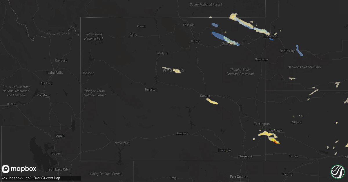
Hail Map in Wyoming on July 13, 2021
Get this storm
July 13 map
$229
one time, instant access
Download today. No call, no setup
Keep the $229
Bought the map and want the full workflow? Apply the entire $229 to a subscription within 7 days. None of it is wasted.
Every map, not just this one
This buys you this map. Subscription and you get every map we run, in the markets you choose from a few cities to whole states to nationwide. Plus real-time alerts the moment a storm fires.
Contact data
Name, contact info, occupancy, even credit band for addresses in the footprint. You go from where it hit to who to call.
Become the source they trust
Unlimited branding weather history reports on demand. You already have the documented answer ready for the property owner, and you are the one who showed up with it.
Property data and RoofTrace estimates
Pull up any address you have got, its value and the exact code rules for that jurisdiction, straight from One Click Code. Then RoofTrace estimates the squares, pitch, and roof value, priced the way you price.
Storm reports in Wyoming
Wyoming
| Date | Description |
|---|---|
| 07/13/20214:12 AM CDT | At 911 PM MDT, severe thunderstorms were located along a line extending from 3 miles southeast of Arpan to 3 miles southwest of Cement Ridge Lookout, moving southeast at 25 mph. HAZARD...60 mph wind gusts. SOURCE...Radar indicated. IMPACT...Expect damage to roofs, siding, and trees. Severe thunderstorms will be near... Fruitdale and Arpan around 915 PM MDT. Nisland and Savoy around 925 PM MDT. O'Neil Pass around 930 PM MDT.Other locations in the path of these severe thunderstorms includeNewell, Cheyenne Crossing, Terry Peak, Vale, Crooks Tower, Owl Butteand Black Fox Campground.This includes Interstate 90 in South Dakota between Mile Markers 1and 36. |
| 07/13/20213:29 AM CDT | At 829 PM MDT, a severe thunderstorm was located 5 miles east of Rozet, or 19 miles east of Gillette, moving east at 30 mph. HAZARD...60 mph wind gusts and quarter size hail. SOURCE...Radar indicated. IMPACT...Hail damage to vehicles is expected. Expect wind damage to roofs, siding, and trees. This severe thunderstorm will be near... Moorcroft and southwestern Keyhole Reservoir around 845 PM MDT.This includes Interstate 90 in Wyoming between Mile Markers 139 and168. |
| 07/13/20213:25 AM CDT | At 825 PM MDT, a severe thunderstorm was located over Aladdin, or 17 miles northeast of Sundance, moving east at 25 mph. HAZARD...60 mph wind gusts and quarter size hail. SOURCE...Radar indicated. IMPACT...Hail damage to vehicles is expected. Expect wind damage to roofs, siding, and trees. This severe thunderstorm will be near... Beulah around 840 PM MDT.Other locations in the path of this severe thunderstorm include BelleFourche, Crow Peak and northwestern Spearfish.This includes... Interstate 90 in South Dakota between Mile Markers 1 and 9. Interstate 90 in Wyoming between Mile Markers 196 and 207. |
| 07/13/20212:28 AM CDT | At 727 PM MDT, a severe thunderstorm was located 8 miles north of Gillette Airport, or 14 miles north of Gillette, moving east at 30 mph. HAZARD...60 mph wind gusts and nickel size hail. SOURCE...Radar indicated. IMPACT...Expect damage to roofs, siding, and trees. This severe thunderstorm will be near... Gillette Airport around 735 PM MDT.Other locations in the path of this severe thunderstorm includeRozet.This includes Interstate 90 in Wyoming between Mile Markers 130 and147. |
| 07/13/20212:25 AM CDT | At 724 PM MDT, a severe thunderstorm was located 3 miles northeast of New Haven, or 33 miles northwest of Sundance, moving southeast at 40 mph. HAZARD...60 mph wind gusts and nickel size hail. SOURCE...Radar indicated. IMPACT...Expect damage to roofs, siding, and trees. Locations impacted include... Hulett, Alva, Cook Lake, Bear Lodge Campground and Warren Peak.This includes Interstate 90 in Wyoming between Mile Markers 173 and177, and between Mile Markers 181 and 201. |
| 07/13/20212:06 AM CDT | At 706 PM MDT, a severe thunderstorm was located near Teapot Rock, or 30 miles southeast of Kaycee, moving east at 55 mph. HAZARD...60 mph wind gusts and nickel size hail. SOURCE...Radar indicated. IMPACT...Expect damage to roofs, siding, and trees. This severe thunderstorm will remain over mainly rural areas of northeastern Natrona County.This includes Interstate 25 between mile markers 209 and 229. |
| 07/13/20211:54 AM CDT | At 654 PM MDT, a severe thunderstorm was located 7 miles north of Echeta, or 27 miles northwest of Gillette, moving east at 40 mph. HAZARD...60 mph wind gusts and quarter size hail. SOURCE...Radar indicated. IMPACT...Hail damage to vehicles is expected. Expect wind damage to roofs, siding, and trees. This severe thunderstorm will remain over mainly rural areas of northern Campbell County. |
| 07/13/20211:37 AM CDT | At 636 PM MDT, a severe thunderstorm was located 7 miles southeast of Biddle, or 31 miles south of Broadus, moving southeast at 30 mph. HAZARD...60 mph wind gusts and quarter size hail. SOURCE...Radar indicated. IMPACT...Hail damage to vehicles is expected. Expect wind damage to roofs, siding, and trees. Locations impacted include... Alzada, Biddle, Albion, Belle Creek, Hammond and Ridge. |
| 07/13/20211:30 AM CDT | At 629 PM MDT, severe thunderstorms were located along a line extending from 8 miles northwest of Lightning Flat to 15 miles northeast of Recluse to 8 miles north of Spotted Horse, moving southeast at 30 mph. HAZARD...60 mph wind gusts and quarter size hail. SOURCE...Radar indicated. IMPACT...Hail damage to vehicles is expected. Expect wind damage to roofs, siding, and trees. Severe thunderstorms will be near... Lightning Flat around 645 PM MDT.Other locations in the path of these severe thunderstorms includeRecluse, Rockypoint, Weston, New Haven and Oshoto. |
| 07/12/20219:58 PM CDT | 50-60 mph wind gusts with torrential rain. |
| 07/12/20219:45 PM CDT | Very heavy rain |
| 07/12/20219:23 PM CDT | A local report indicates 1.50 inch wind near 10 E DWTN GILLETTE |
| 07/12/20218:55 PM CDT | 0.5 inch hail completely covering the ground |
| 07/12/20218:51 PM CDT | A local report indicates 1.00 inch wind near 7 N DWTN GILLETTE |
| 07/12/20218:49 PM CDT | A local report indicates 1.25 inch wind near 7 N DWTN GILLETTE |
| 07/12/20218:35 PM CDT | A local report indicates 60 MPH wind near 4 N NEW HAVEN |
| 07/12/20218:17 PM CDT | A local report indicates 64 MPH wind near 1 NE ECHETA |
| 07/12/20217:59 PM CDT | A local report indicates 60 MPH wind near 7 NW ROCKYPOINT |
| 07/12/20217:59 PM CDT | A local report indicates 72 MPH wind near 12 SW SPOTTED HORSE |
| 07/12/20217:59 PM CDT | A local report indicates 72 MPH wind near 9 WNW SPOTTED HORSE |
| 07/12/20217:43 PM CDT | Just starting to rain and a lot of cloud to cloud lightning. |
All States Impacted by Hail Map on July 13, 2021
Cities Impacted by Hail Map on July 13, 2021
- Gillette, WY
- Valentine, NE
- Harrisburg, NE
- Broadus, MT
- Hulett, WY
- Moorcroft, WY
- Weston, WY
- Alva, WY
- Sparks, NE
- Lowman, NY
- Erin, NY
- Hempstead, TX
- Oelwein, IA
- Maynard, IA
- New Richmond, WI
- Hudson, WI
- Somerset, WI
- Roberts, WI
- Happy Jack, AZ
- Sedona, AZ
- Vail, AZ
- Superior, WI
- Foxboro, WI
- Thomaston, AL
- Ewing, NE
- Clearwater, NE
- North Platte, NE
- Maxwell, NE
- Lilly, PA
- Williamsport, PA
- Cogan Station, PA
- Hawk Springs, WY
- Bloomfield, NE
- Armagh, PA
- Homer City, PA
- New Florence, PA
- Blairsville, PA
- Rozet, WY
- Lyman, NE
- Yoder, WY
- Torrington, WY
- Gering, NE
- Muncy, PA
- Stapleton, NE
- Franklin, MN
- Morgan, MN
- Martin, SD
- Pottersdale, PA
- Sinnamahoning, PA
- Frenchville, PA
- Driftwood, PA
- Westport, PA
- Karthaus, PA
- Petersburg, PA
- Hughesville, PA
- Flagstaff, AZ
- Ogallah, KS
- Ellis, KS
- Watsontown, PA
- Montgomery, PA
- Montoursville, PA
- Allenwood, PA
- Reynoldsville, PA
- Du Bois, PA
- Overton, NV
- Luthersburg, PA
- Mahaffey, PA
- Punxsutawney, PA
- Glen Campbell, PA
- Julesburg, CO
- Nekoma, KS
- Rozel, KS
- Casper, WY
- Glenrock, WY
- Camp Verde, AZ
- Mayer, AZ
- Cubero, NM
- Port Matilda, PA
- Lake Charles, LA
- Sulphur, LA
- Dequincy, LA
- Ashton, ID
- Brewster, NE
- Ovid, CO
- Terra Alta, WV
- Humphrey, NE
- Dresser, WI
- Pinehurst, TX
- Magnolia, TX
- Stanton, NE
- Trinidad, CO
- Thompson, UT
- Morris, PA
- Cedar Run, PA
- Morton, MN
- Redwood Falls, MN
- Hannibal, NY
- Martville, NY
- Sterling, NY
- Ingomar, MT
- Woodward, PA
- Somerville, TX
- Hayward, WI
- Scottsbluff, NE
- Centerville, TX
- Arnold, NE
- Brady, NE
- Saint Croix Falls, WI
- Wakeeney, KS
- Ransom, KS
- Trout Run, PA
- Page, NE
- Orchard, NE
- Royal, NE
- Vale, SD
- Nisland, SD
- Lagrange, WY
- Churchville, NY
- Le Roy, NY
- Paxton, NE
- Tryon, NE
- Laramie, WY
- Blossburg, PA
- Penn Yan, NY
- Weston, CO
- Spring Mills, PA
- Centre Hall, PA
- Pennsylvania Furnace, PA
- Hays, KS
- Ulster, PA
- Milan, PA
- Walsenburg, CO
- Loganton, PA
- Beulah, WY
- Belle Fourche, SD
- Spearfish, SD
- Aladdin, WY
- Sundance, WY
- Tilden, NE
- Neligh, NE
- Oakdale, NE
- Decaturville, TN
- Philipsburg, PA
- Central Square, NY
- Fulton, NY
- Cincinnatus, NY
- Dewey, AZ
- Largo, FL
- Linn Grove, IA
- Sioux Rapids, IA
- Rushville, NE
- Crookston, NE
- Springview, NE
- Bassett, NE
- Cross Fork, PA
- North Bend, PA
- Winslow, AZ
- Whitman, NE
- Scandia, MN
- Minneapolis, MN
- Primghar, IA
- Hartley, IA
- Chemung, NY
- Waverly, NY
- Millerton, PA
- Lockwood, NY
- Pine City, NY
- Gillett, PA
- Elmira, NY
- Barton, NY
- Wellsburg, NY
- Sedgwick, CO
- Milford, UT
- Marksville, LA
- Jonesville, LA
- Lewisburg, PA
- Creighton, NE
- Westfield, IA
- Merrill, IA
- Osceola, WI
- Sutherland, IA
- Kilgore, NE
- Fairfax, MN
- Dundee, NY
- Archer, IA
- Hospers, IA
- Granville, IA
- Oracle, AZ
- Ganado, AZ
- Stillwater, MN
- Marine On Saint Croix, MN
- Ten Sleep, WY
- Winnetoon, NE
- Watkins Glen, NY
- Rock Stream, NY
- Burdett, NY
- Newell, SD
- Cimarron, NM
- Denham Springs, LA
- Walker, LA
- Cotulla, TX
- Julian, PA
- Dickens, IA
- Huntingdon, PA
- Lufkin, TX
- Sleepy Eye, MN
- Oral, SD
- Forest Hill, LA
- Sheridan Lake, CO
- Tyrone, PA
- Spruce Creek, PA
- Warriors Mark, PA
- State College, PA
- University Park, PA
- Oswego, NY
- Beech Creek, PA
- Renovo, PA
- Zuni, NM
- Waller, TX
- Hollidaysburg, PA
- Bosler, WY
- New Creek, WV
- Mifflinburg, PA
- Saint Onge, SD
- Whitewood, SD
- Divide, CO
- Florissant, CO
- Larned, KS
- Alexandria, LA
- Roaring Spring, PA
- Martinsburg, PA
- Bellefonte, PA
- Fayette, IA
- Littlefield, AZ
- Drifting, PA
- Morrisdale, PA
- Winburne, PA
- Grassflat, PA
- Lanse, PA
- Arthur, NE
- Keystone, NE
- Arvada, WY
- Milton, PA
- Rockwood, PA
- Markleton, PA
- Hay Springs, NE
- Robinson, PA
- Bolivar, PA
- Seward, PA
- Wellsboro, PA
- Clearfield, PA
- Muncy Valley, PA
- Hillsgrove, PA
- Hemingford, NE
- Gallitzin, PA
- Ashville, PA
- Sutherland, NE
- Thermopolis, WY
- Cammal, PA
- Gaines, PA
- Montandon, PA
- New Berlin, PA
- Winfield, PA
- Danville, PA
- Tomball, TX
- Pine Hill, AL
- Tuthill, SD
- Jasper, TX
- Batesland, SD
- Everly, IA
- Jersey Shore, PA
- Keyser, WV
- Saint Paul, MN
- Geismar, LA
- Carville, LA
- Saint Gabriel, LA
- Liberty, PA
- Alliance, NE
- Storm Lake, IA
- Rembrandt, IA
- Albert City, IA
- Starks, LA
- Lecompte, LA
- Woodworth, LA
- Hockley, TX
- Cypress, TX
- Houston, TX
- Cable, WI
- Lock Haven, PA
- Jersey Mills, PA
- Curwensville, PA
- Moshannon, PA
- Pennington, TX
- Groveton, TX
- Brookshire, TX
- Marathon, IA
- Andover, MN
- Anoka, MN
- Eads, CO
- Brookeland, TX
- Fordyce, NE
- Sonoita, AZ
- Bergen, NY
- Ligonier, PA
- Brush Valley, PA
- Penn Run, PA
- Indiana, PA
- Vintondale, PA
- Alamo, NV
- Williamsburg, PA
- Alexandria, PA
- Baton Rouge, LA
- Saint Francis, SD
- Boyce, LA
- San Carlos, AZ
- Peridot, AZ
- Roaring Branch, PA
- Ralston, PA
- Millmont, PA
- Horseheads, NY
- Gordon, NE
- Green River, UT
- Mill Run, PA
- Lead, SD
- Spencer, NY
- Candor, NY
- Ridgeland, WI
- Montgomery, TX
- Newell, IA
- Spencer, IA
- Laurelton, PA
- Clarkdale, AZ
- Brewerton, NY
- Pennellville, NY
- Recluse, WY
- Deadwood, SD
- New Underwood, SD
- Lemont, PA
- Townville, PA
- Polk, PA
- Volant, PA
- Grove City, PA
- Franklin, PA
- Guys Mills, PA
- Cooperstown, PA
- Columbus, PA
- Clarks Mills, PA
- Carlton, PA
- Spring Creek, PA
- Titusville, PA
- New Castle, PA
- Bear Lake, PA
- Jackson Center, PA
- Grand Valley, PA
- Hydetown, PA
- Spartansburg, PA
- Centerville, PA
- New Wilmington, PA
- Union City, PA
- Hadley, PA
- Panama, NY
- Sandy Lake, PA
- Clymer, NY
- Cochranton, PA
- Stoneboro, PA
- Utica, PA
- Mercer, PA
- Corry, PA
- Cambridge Springs, PA
- Waterford, PA
- Wattsburg, PA
- Atlantic, PA
- Greenville, PA
- Transfer, PA
- Saegertown, PA
- Meadville, PA
- Conneaut Lake, PA
- Zelienople, PA
- Renfrew, PA
- Butler, PA
- Prospect, PA
- Fombell, PA
- Evans City, PA
- Harmony, PA
- Lickingville, PA
- Marienville, PA
- Shippenville, PA
- Leeper, PA
- Vowinckel, PA
- Kane, PA
- Crown, PA
- Clarion, PA
- Lucinda, PA
- Tionesta, PA
- Sheffield, PA
- Ludlow, PA
- Altoona, PA
- Duncansville, PA
- Dysart, PA
- Howard, PA
- New Columbia, PA
- Camden, NY
- Constableville, NY
- Middleport, NY
- Waterport, NY
- Lyndonville, NY
- Gasport, NY
- Medina, NY
- Lockport, NY
- Barker, NY
- North Tonawanda, NY
- Himrod, NY
- Dresden, NY
- Keuka Park, NY
- Hammondsport, NY
- Beaver Dams, NY
- Savona, NY
- Bradford, NY
- North Pitcher, NY
- Newark Valley, NY
- Richford, NY
- Owego, NY
- Earlville, NY
- Eaton, NY
- Smithville Flats, NY
- South Otselic, NY
- Lisle, NY
- Whitney Point, NY
- De Ruyter, NY
- Pitcher, NY
- Maine, NY
- Berkshire, NY
- Glen Aubrey, NY
- Georgetown, NY
- McDonough, NY
- Marathon, NY
- Willet, NY
- Nichols, NY
- Norwich, NY
- South Plymouth, NY
- New Berlin, NY
- Oxford, NY
- Sherburne, NY
- Plymouth, NY
- Smyrna, NY


