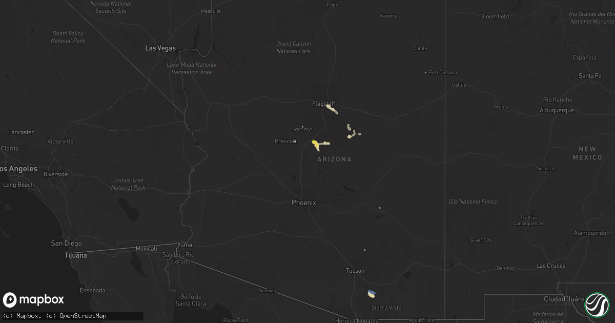
Hail Map in Arizona on July 13, 2021
Get this storm
July 13 map
$229
one time, instant access
Download today. No call, no setup
Keep the $229
Bought the map and want the full workflow? Apply the entire $229 to a subscription within 7 days. None of it is wasted.
Every map, not just this one
This buys you this map. Subscription and you get every map we run, in the markets you choose from a few cities to whole states to nationwide. Plus real-time alerts the moment a storm fires.
Contact data
Name, contact info, occupancy, even credit band for addresses in the footprint. You go from where it hit to who to call.
Become the source they trust
Unlimited branding weather history reports on demand. You already have the documented answer ready for the property owner, and you are the one who showed up with it.
Property data and RoofTrace estimates
Pull up any address you have got, its value and the exact code rules for that jurisdiction, straight from One Click Code. Then RoofTrace estimates the squares, pitch, and roof value, priced the way you price.
Storm reports in Arizona
Arizona
| Date | Description |
|---|---|
| 07/13/20215:30 PM CDT | Empire raws measured a 63 mph wind gust. |
| 07/13/20218:25 AM CDT | High winds lasted from approximately 0625 to 0720... And the peak gust occurred at 0645. A spotter also reported a downed tree at the fairgrounds. This is believed to h |
| 07/13/20216:33 AM CDT | ***delayed report*** significant damage to a home near 181st ave and orangewood ave ... Including a destroyed patio... Roof partially torn off... And flag pole bent in |
| 07/13/20213:52 AM CDT | At 852 PM PDT/852 PM MST/, a severe thunderstorm was located over Echo Bay, or 13 miles south of Overton, and is nearly stationary. HAZARD...60 mph wind gusts. SOURCE...Radar indicated. IMPACT...Expect damage to roofs and trees. Locations impacted include... Mesquite, Boulder City, Las Vegas Bay, Overton, Moapa Valley, Echo Bay, Boulder Beach, Boulder Beach Campground, Las Vegas Bay Campground, Echo Bay Campground, Callville Bay, Meadview, Hoover Dam, Bunkerville, Valley Of Fire, Callville Bay Campground, Lake Mead National Recreation Area, Temple Bar Campground, Overton Beach and South Cove.This includes Interstate 15 in Nevada between mile markers 116 and120. |
| 07/13/20213:29 AM CDT | At 829 PM MST, a severe thunderstorm was located over Littlefield, moving southeast at 15 mph. HAZARD...60 mph wind gusts. SOURCE...Radar indicated. IMPACT...Expect damage to roofs and trees. Locations impacted include... Colorado City, Virgin River Gorge, Beaver Dam, Littlefield, Virgin River Campground, Kaibab and Pipe Spring.This includes Interstate 15 in Arizona between mile markers 0 and 2,and between mile markers 4 and 29. |
| 07/13/20212:24 AM CDT | At 723 PM PDT/723 PM MST/, severe thunderstorms were located along a line extending from near Bunkerville to near Overton to 11 miles west of Valley Of Fire, moving southeast at 25 mph. HAZARD...60 mph wind gusts. SOURCE...Radar indicated. IMPACT...Expect damage to roofs and trees. Locations impacted include... Mesquite, Boulder City, Las Vegas Bay, Overton, Moapa Valley, Echo Bay, Boulder Beach, Boulder Beach Campground, Echo Bay Campground, Callville Bay, Meadview, Hoover Dam, Bunkerville, Valley Of Fire, Callville Bay Campground, Lake Mead National Recreation Area, Temple Bar Campground, Overton Beach, South Cove and Temple Bar. |
| 07/12/202111:58 PM CDT | At 457 PM MST, a severe thunderstorm was located over Oracle, moving west at 10 mph. HAZARD...60 mph wind gusts and penny size hail. SOURCE...Radar indicated. IMPACT...Expect damage to roofs, siding, and trees. Locations impacted include... Oracle, Saddlebrooke, Campo Bonito and Biosphere 2. This includes Route 77 between mile markers 92 and 110. |
| 07/12/202110:55 PM CDT | Corrects previous tstm wnd dmg report from 1 n littlefield. Winds resulting in fallen trees blocking roadways and trees falling on power lines resulting in power outage |
| 07/12/202110:27 PM CDT | At 326 PM MST, a severe thunderstorm was located over Camp Verde, and is nearly stationary. HAZARD...60 mph wind gusts and half dollar size hail. SOURCE...Radar indicated. IMPACT...Hail damage to vehicles is expected. Expect wind damage to roofs, siding, and trees. Locations impacted include... Camp Verde, Mcguireville, Montezuma Well, Montezuma Castle National Monument, Rimrock, Middle Verde, Lake Montezuma and Clear Creek Campgrounds. |
| 07/12/202110:02 PM CDT | At 301 PM MST, a severe thunderstorm was located near Sonoita, or 21 miles southwest of Benson, moving west at 10 mph. HAZARD...60 mph wind gusts and nickel size hail. SOURCE...Radar indicated. IMPACT...Expect damage to roofs, siding, and trees. Locations impacted include... Sonoita and Elgin. This includes the following highways... Route 82 between mile markers 23 and 47. Route 83 between mile markers 19 and 48. |
| 07/12/20219:54 PM CDT | At 254 PM MST, a severe thunderstorm was located 9 miles northwest of Strawberry, or 14 miles east of Camp Verde, moving west at 10 mph. HAZARD...60 mph wind gusts and half dollar size hail. SOURCE...Radar indicated. IMPACT...Hail damage to vehicles is expected. Expect wind damage to roofs, siding, and trees. This severe thunderstorm will remain over mainly rural areas of Yavapai County. |
All States Impacted by Hail Map on July 13, 2021
Cities Impacted by Hail Map on July 13, 2021
- Gillette, WY
- Valentine, NE
- Harrisburg, NE
- Broadus, MT
- Hulett, WY
- Moorcroft, WY
- Weston, WY
- Alva, WY
- Sparks, NE
- Lowman, NY
- Erin, NY
- Hempstead, TX
- Oelwein, IA
- Maynard, IA
- New Richmond, WI
- Hudson, WI
- Somerset, WI
- Roberts, WI
- Happy Jack, AZ
- Sedona, AZ
- Vail, AZ
- Superior, WI
- Foxboro, WI
- Thomaston, AL
- Ewing, NE
- Clearwater, NE
- North Platte, NE
- Maxwell, NE
- Lilly, PA
- Williamsport, PA
- Cogan Station, PA
- Hawk Springs, WY
- Bloomfield, NE
- Armagh, PA
- Homer City, PA
- New Florence, PA
- Blairsville, PA
- Rozet, WY
- Lyman, NE
- Yoder, WY
- Torrington, WY
- Gering, NE
- Muncy, PA
- Stapleton, NE
- Franklin, MN
- Morgan, MN
- Martin, SD
- Pottersdale, PA
- Sinnamahoning, PA
- Frenchville, PA
- Driftwood, PA
- Westport, PA
- Karthaus, PA
- Petersburg, PA
- Hughesville, PA
- Flagstaff, AZ
- Ogallah, KS
- Ellis, KS
- Watsontown, PA
- Montgomery, PA
- Montoursville, PA
- Allenwood, PA
- Reynoldsville, PA
- Du Bois, PA
- Overton, NV
- Luthersburg, PA
- Mahaffey, PA
- Punxsutawney, PA
- Glen Campbell, PA
- Julesburg, CO
- Nekoma, KS
- Rozel, KS
- Casper, WY
- Glenrock, WY
- Camp Verde, AZ
- Mayer, AZ
- Cubero, NM
- Port Matilda, PA
- Lake Charles, LA
- Sulphur, LA
- Dequincy, LA
- Ashton, ID
- Brewster, NE
- Ovid, CO
- Terra Alta, WV
- Humphrey, NE
- Dresser, WI
- Pinehurst, TX
- Magnolia, TX
- Stanton, NE
- Trinidad, CO
- Thompson, UT
- Morris, PA
- Cedar Run, PA
- Morton, MN
- Redwood Falls, MN
- Hannibal, NY
- Martville, NY
- Sterling, NY
- Ingomar, MT
- Woodward, PA
- Somerville, TX
- Hayward, WI
- Scottsbluff, NE
- Centerville, TX
- Arnold, NE
- Brady, NE
- Saint Croix Falls, WI
- Wakeeney, KS
- Ransom, KS
- Trout Run, PA
- Page, NE
- Orchard, NE
- Royal, NE
- Vale, SD
- Nisland, SD
- Lagrange, WY
- Churchville, NY
- Le Roy, NY
- Paxton, NE
- Tryon, NE
- Laramie, WY
- Blossburg, PA
- Penn Yan, NY
- Weston, CO
- Spring Mills, PA
- Centre Hall, PA
- Pennsylvania Furnace, PA
- Hays, KS
- Ulster, PA
- Milan, PA
- Walsenburg, CO
- Loganton, PA
- Beulah, WY
- Belle Fourche, SD
- Spearfish, SD
- Aladdin, WY
- Sundance, WY
- Tilden, NE
- Neligh, NE
- Oakdale, NE
- Decaturville, TN
- Philipsburg, PA
- Central Square, NY
- Fulton, NY
- Cincinnatus, NY
- Dewey, AZ
- Largo, FL
- Linn Grove, IA
- Sioux Rapids, IA
- Rushville, NE
- Crookston, NE
- Springview, NE
- Bassett, NE
- Cross Fork, PA
- North Bend, PA
- Winslow, AZ
- Whitman, NE
- Scandia, MN
- Minneapolis, MN
- Primghar, IA
- Hartley, IA
- Chemung, NY
- Waverly, NY
- Millerton, PA
- Lockwood, NY
- Pine City, NY
- Gillett, PA
- Elmira, NY
- Barton, NY
- Wellsburg, NY
- Sedgwick, CO
- Milford, UT
- Marksville, LA
- Jonesville, LA
- Lewisburg, PA
- Creighton, NE
- Westfield, IA
- Merrill, IA
- Osceola, WI
- Sutherland, IA
- Kilgore, NE
- Fairfax, MN
- Dundee, NY
- Archer, IA
- Hospers, IA
- Granville, IA
- Oracle, AZ
- Ganado, AZ
- Stillwater, MN
- Marine On Saint Croix, MN
- Ten Sleep, WY
- Winnetoon, NE
- Watkins Glen, NY
- Rock Stream, NY
- Burdett, NY
- Newell, SD
- Cimarron, NM
- Denham Springs, LA
- Walker, LA
- Cotulla, TX
- Julian, PA
- Dickens, IA
- Huntingdon, PA
- Lufkin, TX
- Sleepy Eye, MN
- Oral, SD
- Forest Hill, LA
- Sheridan Lake, CO
- Tyrone, PA
- Spruce Creek, PA
- Warriors Mark, PA
- State College, PA
- University Park, PA
- Oswego, NY
- Beech Creek, PA
- Renovo, PA
- Zuni, NM
- Waller, TX
- Hollidaysburg, PA
- Bosler, WY
- New Creek, WV
- Mifflinburg, PA
- Saint Onge, SD
- Whitewood, SD
- Divide, CO
- Florissant, CO
- Larned, KS
- Alexandria, LA
- Roaring Spring, PA
- Martinsburg, PA
- Bellefonte, PA
- Fayette, IA
- Littlefield, AZ
- Drifting, PA
- Morrisdale, PA
- Winburne, PA
- Grassflat, PA
- Lanse, PA
- Arthur, NE
- Keystone, NE
- Arvada, WY
- Milton, PA
- Rockwood, PA
- Markleton, PA
- Hay Springs, NE
- Robinson, PA
- Bolivar, PA
- Seward, PA
- Wellsboro, PA
- Clearfield, PA
- Muncy Valley, PA
- Hillsgrove, PA
- Hemingford, NE
- Gallitzin, PA
- Ashville, PA
- Sutherland, NE
- Thermopolis, WY
- Cammal, PA
- Gaines, PA
- Montandon, PA
- New Berlin, PA
- Winfield, PA
- Danville, PA
- Tomball, TX
- Pine Hill, AL
- Tuthill, SD
- Jasper, TX
- Batesland, SD
- Everly, IA
- Jersey Shore, PA
- Keyser, WV
- Saint Paul, MN
- Geismar, LA
- Carville, LA
- Saint Gabriel, LA
- Liberty, PA
- Alliance, NE
- Storm Lake, IA
- Rembrandt, IA
- Albert City, IA
- Starks, LA
- Lecompte, LA
- Woodworth, LA
- Hockley, TX
- Cypress, TX
- Houston, TX
- Cable, WI
- Lock Haven, PA
- Jersey Mills, PA
- Curwensville, PA
- Moshannon, PA
- Pennington, TX
- Groveton, TX
- Brookshire, TX
- Marathon, IA
- Andover, MN
- Anoka, MN
- Eads, CO
- Brookeland, TX
- Fordyce, NE
- Sonoita, AZ
- Bergen, NY
- Ligonier, PA
- Brush Valley, PA
- Penn Run, PA
- Indiana, PA
- Vintondale, PA
- Alamo, NV
- Williamsburg, PA
- Alexandria, PA
- Baton Rouge, LA
- Saint Francis, SD
- Boyce, LA
- San Carlos, AZ
- Peridot, AZ
- Roaring Branch, PA
- Ralston, PA
- Millmont, PA
- Horseheads, NY
- Gordon, NE
- Green River, UT
- Mill Run, PA
- Lead, SD
- Spencer, NY
- Candor, NY
- Ridgeland, WI
- Montgomery, TX
- Newell, IA
- Spencer, IA
- Laurelton, PA
- Clarkdale, AZ
- Brewerton, NY
- Pennellville, NY
- Recluse, WY
- Deadwood, SD
- New Underwood, SD
- Lemont, PA
- Townville, PA
- Polk, PA
- Volant, PA
- Grove City, PA
- Franklin, PA
- Guys Mills, PA
- Cooperstown, PA
- Columbus, PA
- Clarks Mills, PA
- Carlton, PA
- Spring Creek, PA
- Titusville, PA
- New Castle, PA
- Bear Lake, PA
- Jackson Center, PA
- Grand Valley, PA
- Hydetown, PA
- Spartansburg, PA
- Centerville, PA
- New Wilmington, PA
- Union City, PA
- Hadley, PA
- Panama, NY
- Sandy Lake, PA
- Clymer, NY
- Cochranton, PA
- Stoneboro, PA
- Utica, PA
- Mercer, PA
- Corry, PA
- Cambridge Springs, PA
- Waterford, PA
- Wattsburg, PA
- Atlantic, PA
- Greenville, PA
- Transfer, PA
- Saegertown, PA
- Meadville, PA
- Conneaut Lake, PA
- Zelienople, PA
- Renfrew, PA
- Butler, PA
- Prospect, PA
- Fombell, PA
- Evans City, PA
- Harmony, PA
- Lickingville, PA
- Marienville, PA
- Shippenville, PA
- Leeper, PA
- Vowinckel, PA
- Kane, PA
- Crown, PA
- Clarion, PA
- Lucinda, PA
- Tionesta, PA
- Sheffield, PA
- Ludlow, PA
- Altoona, PA
- Duncansville, PA
- Dysart, PA
- Howard, PA
- New Columbia, PA
- Camden, NY
- Constableville, NY
- Middleport, NY
- Waterport, NY
- Lyndonville, NY
- Gasport, NY
- Medina, NY
- Lockport, NY
- Barker, NY
- North Tonawanda, NY
- Himrod, NY
- Dresden, NY
- Keuka Park, NY
- Hammondsport, NY
- Beaver Dams, NY
- Savona, NY
- Bradford, NY
- North Pitcher, NY
- Newark Valley, NY
- Richford, NY
- Owego, NY
- Earlville, NY
- Eaton, NY
- Smithville Flats, NY
- South Otselic, NY
- Lisle, NY
- Whitney Point, NY
- De Ruyter, NY
- Pitcher, NY
- Maine, NY
- Berkshire, NY
- Glen Aubrey, NY
- Georgetown, NY
- McDonough, NY
- Marathon, NY
- Willet, NY
- Nichols, NY
- Norwich, NY
- South Plymouth, NY
- New Berlin, NY
- Oxford, NY
- Sherburne, NY
- Plymouth, NY
- Smyrna, NY


