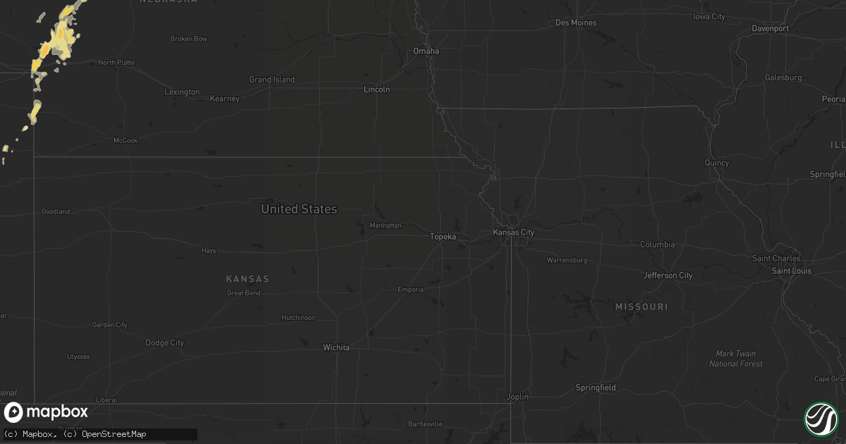
Hail Map in North Dakota on July 13, 2013
Get this storm
July 13 map
$229
one time, instant access
Download today. No call, no setup
Keep the $229
Bought the map and want the full workflow? Apply the entire $229 to a subscription within 7 days. None of it is wasted.
Every map, not just this one
This buys you this map. Subscription and you get every map we run, in the markets you choose from a few cities to whole states to nationwide. Plus real-time alerts the moment a storm fires.
Contact data
Name, contact info, occupancy, even credit band for addresses in the footprint. You go from where it hit to who to call.
Become the source they trust
Unlimited branding weather history reports on demand. You already have the documented answer ready for the property owner, and you are the one who showed up with it.
Property data and RoofTrace estimates
Pull up any address you have got, its value and the exact code rules for that jurisdiction, straight from One Click Code. Then RoofTrace estimates the squares, pitch, and roof value, priced the way you price.
Storm reports in North Dakota
North Dakota
| Date | Description |
|---|---|
| 07/13/20136:55 PM CDT | Tree branches broken. Power out in the area. Rain was 1.75 inches in 45 minutes. No hail. |
| 07/13/20136:45 PM CDT | A local report indicates 58 MPH wind near 5 S BOWBELLS |
| 07/13/20136:20 PM CDT | A local report indicates 62 MPH wind near 1 E WATFORD CITY |
| 07/13/20135:50 PM CDT | A local report indicates 60 MPH wind near 6 NNW WILLISTON |
| 07/13/20135:48 PM CDT | Ongoing |
| 07/13/20135:32 PM CDT | A few stones. No damage. |
| 07/13/20135:18 PM CDT | 1.25 inches of rain. |
| 07/13/20135:00 PM CDT | No damage. |
| 07/12/20139:01 PM CDT | A local report indicates 58 MPH wind near 2 N ROLLA |
| 07/12/20138:37 PM CDT | A local report indicates 70 MPH wind near 2 W DUNSEITH |
| 07/12/20138:05 PM CDT | Very heavy rain was also reported. |
| 07/12/20137:53 PM CDT | Public report to nws bismarck facebook page. |
| 07/12/20137:19 PM CDT | A local report indicates 58 MPH wind near 5 S ANTLER |
| 07/12/20137:19 PM CDT | Small branches broken off trees. |
All States Impacted by Hail Map on July 13, 2013
Cities Impacted by Hail Map on July 13, 2013
- Selma, AL
- Douglas, AZ
- Little River, AL
- Luverne, AL
- Rutledge, AL
- Killdeer, ND
- Elbert, CO
- Colorado Springs, CO
- Epping, ND
- Ray, ND
- Williston, ND
- Venango, NE
- Watford City, ND
- Arnegard, ND
- Cartwright, ND
- Arthur, NE
- Huntingburg, IN
- Lebanon, KY
- Loretto, KY
- Springfield, KY
- Roberts, MT
- Sutherland, NE
- Crosby, ND
- Noonan, ND
- Bird City, KS
- Brighton, CO
- Commerce City, CO
- Arriba, CO
- Hugo, CO
- Lacombe, LA
- Liberty, KY
- Columbia, KY
- Dunnville, KY
- Russell Springs, KY
- Gulfport, MS
- Padroni, CO
- Bowman, ND
- Paxton, NE
- Honoraville, AL
- Akron, CO
- Beattyville, KY
- Picayune, MS
- Pearl River, LA
- Stennis Space Center, MS
- Selby, SD
- Amidon, ND
- Johnstown, NE
- Biloxi, MS
- Alamo, ND
- Zahl, ND
- Grenora, ND
- Wray, CO
- Bardstown, KY
- New Haven, KY
- Sundance, WY
- Belle Fourche, SD
- Beulah, WY
- Aladdin, WY
- Campbellsville, KY
- Saint David, AZ
- Bridger, MT
- Lodge Grass, MT
- Lowndesboro, AL
- Detroit, AL
- Sidney, MT
- Alexander, ND
- Milton, FL
- Hope Hull, AL
- Windsor, KY
- Trail City, SD
- Limon, CO
- Eckley, CO
- Yuma, CO
- Plantersville, AL
- Atmore, AL
- Glenham, SD
- Center, NE
- Bloomfield, NE
- Niobrara, NE
- Foley, AL
- Reva, SD
- Champion, NE
- Holyoke, CO
- Alexander City, AL
- Saint Onge, SD
- Tioga, ND
- Brule, NE
- Irvington, AL
- Springview, NE
- Wakpala, SD
- Seminole, AL
- Saint Francis, KS
- Pryor, MT
- Kellyton, AL
- Equality, AL
- McLaughlin, SD
- Century, FL
- McDavid, FL
- Molino, FL
- Robertsdale, AL
- Elk Horn, KY
- Nancy, KY
- Alva, WY
- Marion, AL
- Baxter, TN
- Eagle Butte, SD
- Gettysburg, SD
- Highland Home, AL
- Lapine, AL
- Seibert, CO
- Genoa, CO
- Albany, KY
- Burkesville, KY
- Lemoyne, NE
- Lewellen, NE
- Ogallala, NE
- Keystone, NE
- Grassy Butte, ND
- Brush, CO
- Ramah, CO
- Laramie, WY
- Ainsworth, NE
- Pensacola, FL
- Coffeeville, AL
- Big Springs, NE
- Somerset, KY
- Perkinston, MS
- Herreid, SD
- Whitman, NE
- Hyannis, NE
- Julesburg, CO
- Mullen, NE
- Cantonment, FL
- Roscoe, SD
- Frisco City, AL
- Freeport, FL
- Defuniak Springs, FL
- Whitley City, KY
- Parkers Lake, KY
- Elberta, AL
- Agate, CO
- Palatka, FL
- Vancleave, MS
- Ambrose, ND
- Wells, MN
- Lumberton, MS
- Glencross, SD
- Cheyenne, WY
- Onida, SD
- Pierre, SD
- Agar, SD
- Fortuna, ND
- Kiln, MS
- Platte, SD
- Java, SD
- Quitman, MS
- Millry, AL
- Killen, AL
- Spearfish, SD
- Franklin, GA
- Saraland, AL
- Gulf Shores, AL
- Fairview, MT
- Timber Lake, SD
- McLain, MS
- Elba, AL
- Golden, CO
- Monroeville, AL
- Vredenburgh, AL
- Hillsboro, KS
- Lehigh, KS
- Eight Mile, AL
- Maplesville, AL
- Williamsburg, KY
- State Line, MS
- Saucier, MS
- Slidell, LA
- Grand Bay, AL
- Citronelle, AL
- Lucedale, MS
- Leakesville, MS
- Verdigre, NE
- New Brockton, AL
- Burke, SD
- Clanton, AL
- Liberty, TN
- Alexandria, TN
- Hickman, TN
- Mobridge, SD
- Roggen, CO
- Scranton, ND
- Gregory, SD
- Orrville, AL
- Jones, AL
- Cherokee, AL
- Easton, MN
- Burnside, KY
- Uniontown, AL
- Safford, AL
- Marion Junction, AL
- Pollock, SD
- Pine Knot, KY
- Bay Minette, AL
- Orange Beach, AL
- Vernon, FL
- Satsuma, FL
- Mount Vernon, KY
- Orlando, KY
- Louin, MS
- London, KY
- Long Pine, NE
- Fromberg, MT
- Allred, TN
- Rickman, TN
- Columbus, ND
- Hamilton, AL
- Bainville, MT
- Bradfordsville, KY
- Mannsville, KY


