Hail Map on July 11, 2022
Get this storm
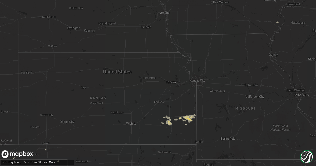
July 11 map
$229
one time, instant access
Download today. No call, no setup
Keep the $229
Bought the map and want the full workflow? Apply the entire $229 to a subscription within 7 days. None of it is wasted.
Every map, not just this one
This buys you this map. Subscription and you get every map we run, in the markets you choose from a few cities to whole states to nationwide. Plus real-time alerts the moment a storm fires.
Contact data
Name, contact info, occupancy, even credit band for addresses in the footprint. You go from where it hit to who to call.
Become the source they trust
Unlimited branding weather history reports on demand. You already have the documented answer ready for the property owner, and you are the one who showed up with it.
Property data and RoofTrace estimates
Pull up any address you have got, its value and the exact code rules for that jurisdiction, straight from One Click Code. Then RoofTrace estimates the squares, pitch, and roof value, priced the way you price.
States Impacted by Hail Map on July 11, 2022
Storm reports
Alaska
| Date | Description |
|---|---|
| 07/11/20221:55 AM CDT | At 655 PM AKDT, a severe thunderstorm was located 37 miles east of Twelvemile Summit, moving southeast at 20 mph. HAZARD...Quarter size hail. SOURCE...Radar indicated. IMPACT...Damage to vehicles is expected. Locations impacted include... Circle Hot Springs and Central. |
Mississippi
| Date | Description |
|---|---|
| 07/11/20221:36 AM CDT | At 635 PM CDT, a severe thunderstorm was located near Midtown and Downtown Mobile, moving southwest at 20 mph. HAZARD...60 mph wind gusts. SOURCE...Radar indicated. IMPACT...Expect damage to roofs, siding, and trees. Locations impacted include... Midtown Mobile, Downtown Mobile, Prichard, Tillmans Corner, Theodore, Chickasaw, Semmes, Tanner Williams, I65 And I165, I65 And AL 158, I10 And I65 and Mobile Regional Airport. |
Wisconsin
| Date | Description |
|---|---|
| 07/11/20226:10 PM CDT | Trees and powerlines down near the intersection of county road c and cr. |
| 07/11/20223:19 PM CDT | Measured gust at keau. |
| 07/11/20222:01 AM CDT | At 700 PM CDT, a severe thunderstorm was located near Beaver Dam, moving east at 50 mph. HAZARD...60 mph wind gusts and quarter size hail. SOURCE...Radar indicated. IMPACT...Hail damage to vehicles is expected. Expect wind damage to roofs, siding, and trees. Locations impacted include... Beaver Dam, Hartford, Slinger, Horicon, Juneau, Hustisford, Iron Ridge, Addison, Rubicon, Lebanon, Woodland, Neosho, Clyman, Lowell, Nenno, Holy Hill, Allenton, South Beaver Dam, Minnesota Junction and Monches. |
| 07/10/20228:00 PM CDT | Estimated winds 50-60 mph. Relayed by broadcast media. |
| 07/10/20227:46 PM CDT | Report from mping: 1-inch tree limbs broken; shingles blown off. |
Alabama
| Date | Description |
|---|---|
| 07/11/20226:50 PM CDT | Report of a tree down on a house on west daniels rd. Time estimated from radar. |
| 07/11/20226:45 PM CDT | Reports of multiple power lines down on dauphin island parkway... One blocking the roadway. Time estimated from radar. |
| 07/11/20225:55 PM CDT | Reports of multiple trees and power lines down in the vicinity of the crossroads and whitehouse forks communities. Time estimated between 550-600 pm from radar. |
| 07/11/20221:01 AM CDT | At 600 PM CDT, severe thunderstorms were located along a line extending from Creola to 5 miles west of Stapleton, moving southwest at 20 mph. HAZARD...60 mph wind gusts. SOURCE...Radar indicated. IMPACT...Expect damage to roofs, siding, and trees. Locations impacted include... Midtown Mobile, Downtown Mobile, Prichard, Tillmans Corner, Saraland, Chickasaw, Satsuma, Spanish Fort, Creola, Axis, I65 And I165, Mobile Regional Airport, I65 And AL 158 and I10 And I65. |
| 07/11/202212:50 AM CDT | At 550 PM CDT, a severe thunderstorm was located 4 miles northwest of Stapleton, or 6 miles southwest of Bay Minette, moving southwest at 15 mph. HAZARD...60 mph wind gusts. SOURCE...Radar indicated. IMPACT...Expect damage to roofs, siding, and trees. Locations impacted include... Spanish Fort and Stapleton. |
Nebraska
| Date | Description |
|---|---|
| 07/11/20227:59 AM CDT | At 1259 AM CDT, severe thunderstorms were located along a line extending from 9 miles north of Newman Grove to 3 miles south of Genoa, moving east at 55 mph. HAZARD...60 mph wind gusts. SOURCE...Radar indicated. IMPACT...Expect damage to roofs, siding, and trees. Severe thunderstorms will be near... Monroe around 105 AM CDT. Battle Creek and Duncan around 110 AM CDT. Madison and Lakeview around 115 AM CDT.Other locations in the path of these severe thunderstorms includeColumbus, Stanton, Richland, Schuyler, Pilger, Linwood and Wisner.People attending Madison County Fairgrounds should seek safe shelterimmediately! |
| 07/11/20227:32 AM CDT | At 1232 AM CDT, severe thunderstorms were located along a line extending from 8 miles southeast of Bartlett to 5 miles northeast of Wolbach, moving northeast at 45 mph. HAZARD...60 mph wind gusts. SOURCE...Radar indicated. IMPACT...Expect damage to roofs, siding, and trees. Severe thunderstorms will be near... Cedar Rapids around 1245 AM CDT. Petersburg around 1250 AM CDT.Other locations in the path of these severe thunderstorms includeElgin, St. Edward, Oakdale, Tilden, Newman Grove and Lindsay. |
| 07/11/20227:06 AM CDT | At 1206 AM CDT, severe thunderstorms were located along a line extending from 8 miles east of Fort Hartsuff State Park to 9 miles south of Ericson to near Scotia, moving east at 35 mph. HAZARD...60 mph wind gusts. SOURCE...Radar indicated. IMPACT...Expect damage to roofs, siding, and trees. Locations impacted include... Bartlett, Ericson and Pibel Lake State Recreation Area. This includes Highway 281 between mile markers 132 and 146. |
| 07/11/20227:01 AM CDT | At 1201 AM CDT, a severe thunderstorm was located near North Loup, or 11 miles east of Ord, moving east at 55 mph. HAZARD...60 mph wind gusts. SOURCE...Radar indicated. IMPACT...Expect damage to roofs, siding, and trees. This severe thunderstorm will be near... Greeley around 1210 AM CDT.Other locations in the path of this severe thunderstorm includeSpalding. |
| 07/11/202212:03 AM CDT | At 502 AM CDT, a severe thunderstorm was located 4 miles south of Seward, moving east at 35 mph. HAZARD...60 mph wind gusts. SOURCE...Radar indicated. IMPACT...Expect damage to roofs, siding, and trees. This severe thunderstorm will be near... Pleasant Dale around 520 AM CDT.Other locations in the path of this severe thunderstorm includeMalcolm and Emerald.This includes Interstate 80 in Nebraska between mile markers 369 and392. |
| 07/10/20229:42 PM CDT | At 242 AM CDT, severe thunderstorms were located along a line extending from 4 miles southwest of Blencoe to 3 miles east of Mondamin to 3 miles northeast of Fort Calhoun, moving east at 55 mph. HAZARD...60 mph wind gusts. SOURCE...Radar indicated. IMPACT...Expect damage to roofs, siding, and trees. Severe thunderstorms will be near... Logan around 250 AM CDT. Woodbine around 255 AM CDT.Other locations in the path of these severe thunderstorms includePersia, Dunlap, Shelby, Panama, Harlan, Earling and Defiance.This includes Interstate 29 between mile markers 74 and 82, andbetween mile markers 95 and 101. |
| 07/10/20228:42 PM CDT | At 141 AM CDT, severe thunderstorms were located along a line extending from 2 miles north of Stanton to 3 miles southeast of Clarkson to 3 miles southeast of Columbus, moving east at 60 mph. HAZARD...70 mph wind gusts. SOURCE...Radar indicated. IMPACT...Expect considerable tree damage. Damage is likely to mobile homes, roofs, and outbuildings. Severe thunderstorms will be near... Howells around 145 AM CDT. Dodge and Pilger around 150 AM CDT. Schuyler, Wisner and Snyder around 155 AM CDT. Scribner, Beemer and Linwood around 200 AM CDT.Other locations in the path of these severe thunderstorms includeNorth Bend, Uehling, Morse Bluff, Oakland, Bancroft, Craig, Rosalie,Lyons, Cedar Bluffs, Fremont, Tekamah, Nickerson, Inglewood andWoodcliff. |
| 07/10/20228:09 PM CDT | At 108 AM MDT, a severe thunderstorm was located over Imperial, moving north at 20 mph. HAZARD...60 mph wind gusts. SOURCE...Public. IMPACT...Expect damage to roofs, siding, and trees. Locations impacted include... Imperial, Grant, Madrid, Elsie, Enders, Champion, Center Dam Campground and Wanamaker State Wildfire Management Area.This includes Highway 61 between mile markers 41 and 68. |
| 07/10/20228:00 PM CDT | At 100 AM CDT, a severe thunderstorm was located near St. Edward, or 26 miles west of Columbus, moving east at 30 mph. HAZARD...60 mph wind gusts and half dollar size hail. SOURCE...Radar indicated. IMPACT...Hail damage to vehicles is expected. Expect wind damage to roofs, siding, and trees. This severe thunderstorm will be near... Genoa around 115 AM CDT. |
Minnesota
| Date | Description |
|---|---|
| 07/11/202212:39 AM CDT | At 538 PM CDT, a severe thunderstorm was located over Thief River Falls, moving south at 25 mph. At 535 PM CDT, trained weather spotters reported nickel size hail in Thief River Falls. HAZARD...60 mph wind gusts and quarter size hail. SOURCE...Trained weather spotters. IMPACT...Hail damage to vehicles is expected. Expect wind damage to roofs, siding, and trees. This severe thunderstorm will be near... St. Hilaire and Hazel around 550 PM CDT. |
Michigan
| Date | Description |
|---|---|
| 07/11/20226:47 AM CDT | At 1147 PM EDT, a severe thunderstorm was located over Ortonville, or 8 miles northeast of Holly, moving east at 40 mph. HAZARD...60 mph wind gusts and penny size hail. SOURCE...Radar indicated. IMPACT...Expect damage to roofs, siding, and trees. This severe thunderstorm will be near... Metamora around 1200 AM EDT. Oxford around 1205 AM EDT. Almont around 1220 AM EDT.Other locations impacted by this severe thunderstorm includeLakeville, Attica, Holly State Recreation Area, Leonard, Lake Orion,Thornville, Davisburg, Rochester Hills and Auburn Hills. |
| 07/11/20226:14 AM CDT | At 1113 PM EDT, a severe thunderstorm was located over Gaines, or near Durand, moving east at 45 mph. HAZARD...60 mph wind gusts and quarter size hail. SOURCE...Radar indicated. IMPACT...Hail damage to vehicles is expected. Expect wind damage to roofs, siding, and trees. This severe thunderstorm will be near... Swartz Creek around 1120 PM EDT. Linden around 1125 PM EDT. Fenton and Lake Fenton around 1130 PM EDT. Grand Blanc around 1135 PM EDT. Goodrich around 1140 PM EDT.Other locations impacted by this severe thunderstorm include Atlas,Argentine and Rankin. |
| 07/11/20225:41 AM CDT | At 1041 PM EDT, a severe thunderstorm was located near Laingsburg, moving east at 40 mph. HAZARD...60 mph wind gusts and penny size hail. SOURCE...Radar indicated. IMPACT...Expect damage to roofs, siding, and trees. This severe thunderstorm will be near... Laingsburg around 1050 PM EDT. Owosso and Perry around 1100 PM EDT. Morrice around 1105 PM EDT. Corunna around 1110 PM EDT. Bancroft around 1115 PM EDT. Durand around 1120 PM EDT. Byron and Lennon around 1125 PM EDT.Other locations impacted by this severe thunderstorm includeBennington and Vernon. |
| 07/11/20223:20 AM CDT | At 820 PM EDT, a severe thunderstorm was located 12 miles northwest of Silver Lake SP, or 17 miles southwest of Ludington, moving east at 45 mph. HAZARD...60 mph wind gusts and quarter size hail. SOURCE...Radar indicated. IMPACT...Hail damage to vehicles is expected. Expect wind damage to roofs, siding, and trees. This severe thunderstorm will be near... Silver Lake SP around 835 PM EDT. Pentwater, Mears SP and Mears around 840 PM EDT.Other locations in the path of this severe thunderstorm include Hart. |
| 07/11/20221:58 AM CDT | At 658 PM EDT, a severe thunderstorm was located 7 miles east of Garden Corners, or 10 miles southwest of Manistique, moving east at 25 mph. HAZARD...Quarter size hail. SOURCE...Radar indicated. IMPACT...Damage to vehicles is expected. Locations impacted include... Manistique. |
| 07/11/20221:38 AM CDT | At 637 PM EDT, a severe thunderstorm was located over Garden, or 18 miles southwest of Manistique, moving northeast at 15 mph. HAZARD...Quarter size hail. SOURCE...Radar indicated. IMPACT...Damage to vehicles is expected. This severe thunderstorm will remain over mainly rural areas of east central Delta and southwestern Schoolcraft Counties, including the following locations... Point Aux Barques. |
| 07/10/202211:10 PM CDT | Trees down. Time estimated by radar. |
| 07/10/202211:08 PM CDT | Trees and wires down. Time estimated by radar. |
| 07/10/202210:50 PM CDT | Wires down. Time estimated by radar. |
| 07/10/202210:33 PM CDT | Report of large tree down through 2nd floor of house. Wires also reported down in area. |
| 07/10/20229:30 PM CDT | Two trees down... Power outages. Time estimated from radar. |
| 07/10/20229:30 PM CDT | Corrects previous tstm wnd dmg report from 4 ssw saint johns. Two trees down... Power outages. Time estimated from radar. |
| 07/10/20228:42 PM CDT | Tree snapped and limbs down. |
Illinois
| Date | Description |
|---|---|
| 07/11/20225:59 PM CDT | Trained spotter reported and relayed pictures of mature trees downed in the vicinity of dickens road... Riverside drive... Winnetka road... And stockton road. At least |
| 07/11/20221:22 AM CDT | At 622 AM CDT, severe thunderstorms were located along a line extending from Sharon Center to Coppock, moving east at 25 mph. HAZARD...60 mph wind gusts and quarter size hail. SOURCE...Radar indicated. IMPACT...Hail damage to vehicles is expected. Expect wind damage to roofs, siding, and trees. Locations impacted include... Muscatine, Washington, Wapello, Columbus Junction, West Liberty, Wilton, Winfield, Riverside, Fruitland, Wayland, Morning Sun, Brighton, Ainsworth, Grandview, Conesville, Columbus City, Letts, Nichols, Atalissa and Crawfordsville. |
New Mexico
| Date | Description |
|---|---|
| 07/11/20224:39 AM CDT | At 939 PM MDT, a severe thunderstorm was located 11 miles northwest of Ute Lake State Park, or 21 miles north of Tucumcari, moving northwest at 10 mph. HAZARD...60 mph wind gusts and quarter size hail. SOURCE...Radar indicated. IMPACT...Hail damage to vehicles is expected. Expect wind damage to roofs, siding, and trees. Locations impacted include... Logan. |
| 07/10/202211:03 PM CDT | At 403 PM MDT, a severe thunderstorm was located near Springer, moving northwest at 10 mph. HAZARD...60 mph wind gusts and quarter size hail. SOURCE...Radar indicated. IMPACT...Hail damage to vehicles is expected. Expect wind damage to roofs, siding, and trees. Locations impacted include... Springer and Maxwell. This includes Interstate 25 between Mile Markers 411 and 431. |
| 07/10/20229:40 PM CDT | Asos station kcao clayton muni airpark. |
| 07/10/20229:31 PM CDT | Asos station kcao clayton muni airpark. |
| 07/10/20228:45 PM CDT | Columbia scientific balloon facility. |
Florida
| Date | Description |
|---|---|
| 07/11/20223:52 PM CDT | Downed tree reported near diesel rd. |
| 07/11/202212:12 AM CDT | At 511 PM EDT, a severe thunderstorm was located near Unf, moving north at 35 mph. HAZARD...60 mph wind gusts. SOURCE...Radar indicated. IMPACT...Expect damage to roofs, siding, and trees. Locations impacted include... Unf, Neptune Beach, Baymeadows, Bayard, Craig Field, San Pablo and Palm Valley. |
| 07/10/202211:30 PM CDT | At 430 PM EDT, a severe thunderstorm was located near World Golf Village, or 7 miles northwest of Saint Augustine, moving north at 15 mph. HAZARD...60 mph wind gusts. SOURCE...Radar indicated. IMPACT...Expect damage to roofs, siding, and trees. Locations impacted include... World Golf Village and Guana River State Park. |
Texas
| Date | Description |
|---|---|
| 07/11/20223:51 AM CDT | At 851 PM CDT, a severe thunderstorm was located near Booker, or 17 miles east of Perryton, moving west at 20 mph. HAZARD...60 mph wind gusts and quarter size hail. SOURCE...Radar indicated. IMPACT...Minor damage to roofs, siding, and trees is possible. Hail damage to vehicles is expected. Locations impacted include... Perryton and Booker. |
| 07/11/20221:39 AM CDT | At 639 PM CDT, a severe thunderstorm was located over Circle D-KC Estates, or 8 miles northeast of Bastrop, moving south at 10 mph. HAZARD...60 mph wind gusts and nickel size hail. SOURCE...Radar indicated. IMPACT...Expect damage to roofs, siding, and trees. Locations impacted include... Bastrop, Smithville, Camp Swift, Paige, Circle D-KC Estates, Upton, Bastrop State Park, Hills Prairie, Buescher State Park and Alum Creek. |
| 07/10/202211:15 PM CDT | At 414 PM CDT, a severe thunderstorm was located near Granger, and is nearly stationary. HAZARD...60 mph wind gusts and penny size hail. SOURCE...Radar indicated. IMPACT...Expect damage to roofs, siding, and trees. Locations impacted include... Georgetown, Taylor, Granger, Weir, Jonah, Waterloo and Walburg. |
South Dakota
| Date | Description |
|---|---|
| 07/11/20227:25 AM CDT | At 1225 AM MDT/125 AM CDT/, severe thunderstorms were located along a line extending from 8 miles east of Belvidere to 9 miles southeast of Long Valley, moving east at 60 mph. HAZARD...60 mph wind gusts and penny size hail. SOURCE...Radar indicated. IMPACT...Expect damage to roofs, siding, and trees. Severe thunderstorms will be near... Parmelee, Upper Cut Meat and He Dog around 140 AM CDT. Grass Mountain around 145 AM CDT.Other locations in the path of these severe thunderstorms includeRosebud, Fairgrounds Housing, Two Strike, Soldier Creek, RingThunder, Mosher, Hidden Timber and Witten.This includes Interstate 90 in South Dakota between Mile Markers 171and 174. |
| 07/10/202210:41 PM CDT | At 341 AM MDT, a severe thunderstorm was located over Merriman, or 16 miles south of Martin, moving southeast at 45 mph. HAZARD...60 mph wind gusts and half dollar size hail. SOURCE...Radar indicated. IMPACT...Hail damage to vehicles is expected. Expect wind damage to roofs, siding, and trees. Locations impacted include... Cody, Merriman, Nenzel, Medicine Lake, Cody Lake, Eli, Highway 61 Crossing The Niobrara River and Schoolhouse Lake.This includes the following highways... Highway 20 between mile markers 128 and 168. Highway 61 between mile markers 217 and 230. |
| 07/10/202210:06 PM CDT | At 306 AM MDT, a severe thunderstorm was located near Batesland, or 18 miles east of Pine Ridge, moving east at 40 mph. HAZARD...60 mph wind gusts and half dollar size hail. SOURCE...Radar indicated. IMPACT...Hail damage to vehicles is expected. Expect wind damage to roofs, siding, and trees. Locations impacted include... Merriman, Highway 61 Crossing The Niobrara River, Hoover Lake, Irwin, Eli and Shell Lake State Wildlife Management Area.This includes the following highways... Highway 20 between mile markers 122 and 153. Highway 61 between mile markers 215 and 231. |
| 07/10/202210:04 PM CDT | At 304 AM MDT, a severe thunderstorm was located 5 miles northwest of Wakpamni, or 18 miles east of Pine Ridge, moving east at 45 mph. HAZARD...60 mph wind gusts and half dollar size hail. SOURCE...Radar indicated. IMPACT...Hail damage to vehicles is expected. Expect wind damage to roofs, siding, and trees. This severe thunderstorm will be near... Batesland around 310 AM MDT.Other locations in the path of this severe thunderstorm includesouthwestern Lacreek Wildlife Refuge. |
| 07/10/20228:41 PM CDT | At 141 AM CDT, a severe thunderstorm was located 9 miles west of Intersection of Highway 83 and White River, or 13 miles southwest of Murdo, moving east at 55 mph. HAZARD...60 mph wind gusts and penny size hail. SOURCE...Radar indicated. IMPACT...Expect damage to roofs, siding, and trees. This severe thunderstorm will be near... Westover around 150 AM CDT. |
Oklahoma
| Date | Description |
|---|---|
| 07/11/20223:45 AM CDT | At 845 PM MDT, severe thunderstorms were located along a line extending from 10 miles northwest of Clayton Lake State Park to 11 miles southwest of Clayton to 11 miles northeast of Bueyeros, moving northeast at 10 mph. HAZARD...60 mph wind gusts and quarter size hail. SOURCE...Radar indicated. IMPACT...Hail damage to vehicles is expected. Expect wind damage to roofs, siding, and trees. Locations impacted include... Clayton, Grenville, Clayton Lake State Park, Seneca, Sedan, Mount Dora, Moses and Bueyeros.This includes Highway 64 between Mile Markers 401 and 429. |
Colorado
| Date | Description |
|---|---|
| 07/10/20229:17 PM CDT | At 217 PM MDT, a severe thunderstorm was located over Divide, or 19 miles northwest of Colorado Springs, and is nearly stationary. HAZARD...60 mph wind gusts and quarter size hail. SOURCE...Radar indicated. IMPACT...Hail damage to vehicles is expected. Expect wind damage to roofs, siding, and trees. Locations impacted include... Divide. |
Iowa
| Date | Description |
|---|---|
| 07/11/20221:40 AM CDT | At 640 AM CDT, severe thunderstorms were located along a line extending from Mount Vernon to West Liberty, moving east at 50 mph. HAZARD...60 mph wind gusts. SOURCE...Radar indicated. IMPACT...Expect damage to roofs, siding, and trees. Locations impacted include... Davenport, Moline, Rock Island, Bettendorf, Muscatine, East Moline, Tipton, West Branch, Durant, Mechanicsville, Stanwood, Silvis, Eldridge, DeWitt, Milan, Mount Vernon, Coal Valley, West Liberty, Wilton and Lisbon. |
| 07/11/202212:43 AM CDT | At 543 AM CDT, severe thunderstorms were located along a line extending from near Clutier to near Holbrook, moving east at 45 mph. HAZARD...60 mph wind gusts and quarter size hail. SOURCE...Radar indicated. IMPACT...Hail damage to vehicles is expected. Expect wind damage to roofs, siding, and trees. Locations impacted include... Cedar Rapids, Iowa City, Vinton, Marengo, Marion, Coralville, North Liberty, Hiawatha, Robins, Williamsburg, Belle Plaine, Center Point, Kalona, Fairfax, Solon, Tiffin, Ely, Atkins, Walford and Urbana. |
| 07/11/202212:41 AM CDT | At 541 AM CDT, severe thunderstorms were located along a line extending from near Grundy Center to 6 miles south of Traer to Belle Plaine, moving northeast at 40 mph. HAZARD...60 mph wind gusts and quarter size hail. SOURCE...Radar indicated. IMPACT...Hail damage to vehicles is expected. Expect wind damage to roofs, siding, and trees. Locations impacted include... Toledo, Tama, Traer, Brooklyn, Dysart, Meskwaki Casino, Gladbrook, Le Grand, Victor, Garwin, Holiday Lake, Liscomb, Chelsea, Montour, Clutier, Elberon, Lincoln, Green Mountain, Hartwick and Vining.This includes Interstate 80 between mile markers 199 and 200. |
| 07/10/202211:44 PM CDT | At 443 AM CDT, severe thunderstorms were located along a line extending from 6 miles southeast of Gowrie to near Boone to near Woodward, moving east at 50 mph. HAZARD...60 mph wind gusts and nickel size hail. SOURCE...Radar indicated. IMPACT...Expect damage to roofs, siding, and trees. Locations impacted include... Ames, Boone, Nevada, Story City, Huxley, Madrid, Ogden, Slater, Roland, Jewell Junction, Gilbert, Gowrie, Woodward, Iowa State Center, Boone Speedway, Maxwell, Colo, Dayton, Cambridge and Grand Junction.This includes Interstate 35 between mile markers 103 and 137. |
| 07/10/202211:20 PM CDT | At 419 AM CDT, severe thunderstorms were located along a line extending from near Gowrie to near Jefferson to 9 miles north of Lake Panorama, moving east at 65 mph. HAZARD...70 mph wind gusts and quarter size hail. SOURCE...Radar indicated. IMPACT...Hail damage to vehicles is expected. Expect considerable tree damage. Wind damage is also likely to mobile homes, roofs, and outbuildings. Locations impacted include... Boone, Jefferson, Madrid, Ogden, Woodward, Boone Speedway, Grand Junction, Sheldahl, Rippey, Boxholm, Pilot Mound, Luther, Fraser, Beaver, Berkley, Jefferson Municipal Airport, Boone Municipal Airport and Ledges State Park. |
| 07/10/202211:05 PM CDT | At 405 AM CDT, a severe thunderstorm was located 10 miles northeast of Glidden, or 12 miles northwest of Jefferson, moving northeast at 70 mph. HAZARD...60 mph wind gusts and quarter size hail. SOURCE...Radar indicated. IMPACT...Hail damage to vehicles is expected. Expect wind damage to roofs, siding, and trees. Locations impacted include... Carroll, Jefferson, Rockwell City, Lake City, Glidden, Lake View, Gowrie, Dayton, Stratford, Scranton, Otho, Breda, Lehigh, Churdan, Callender, Farnhamville, Lohrville, Auburn, Harcourt and Paton. |
| 07/10/202210:35 PM CDT | At 335 AM CDT, severe thunderstorms were located along a line extending from near Danbury to near Denison to near Manning, moving northeast at 50 mph. HAZARD...60 mph wind gusts and quarter size hail. SOURCE...Radar indicated. IMPACT...Hail damage to vehicles is expected. Expect wind damage to roofs, siding, and trees. Locations impacted include... Carroll, Sac City, Rockwell City, Lake City, Manning, Glidden, Lake View, Odebolt, North Twin Lake, Black Hawk Lake, South Twin Lake, Wall Lake, Schaller, Pomeroy, Early, Arcadia, Breda, Lohrville, Templeton and Twin Lakes. |
| 07/10/202210:19 PM CDT | At 319 AM CDT, severe thunderstorms were located along a line extending from Ute to 6 miles northeast of Dunlap to Defiance, moving northeast at 45 mph. HAZARD...60 mph wind gusts. SOURCE...Radar indicated. IMPACT...Expect damage to roofs, siding, and trees. Severe thunderstorms will be near... Buck Grove around 325 AM CDT. Manilla and Denison Municipal Airport around 330 AM CDT. Denison, Ricketts and Aspinwall around 335 AM CDT. Deloit around 340 AM CDT. Schleswig, Vail and Westside around 345 AM CDT. Kiron around 350 AM CDT.Other locations impacted by these severe thunderstorms include Kiron,Charter Oak, Deloit, Vail, Dow City, Schleswig, Denison MunicipalAirport and Buck Grove. |
| 07/10/202210:04 PM CDT | At 304 AM CDT, a severe thunderstorm was located over Moorhead, or 22 miles northeast of Tekamah, moving east at 50 mph. HAZARD...60 mph wind gusts. SOURCE...Radar indicated. IMPACT...Expect damage to roofs, siding, and trees. This severe thunderstorm will be near... Ute around 315 AM CDT. |
| 07/10/20229:13 PM CDT | At 212 AM CDT, severe thunderstorms were located along a line extending from 6 miles west of Oakland to 2 miles northwest of Nickerson to 4 miles northwest of Colon, moving east at 55 mph. HAZARD...60 mph wind gusts. SOURCE...Radar indicated. IMPACT...Expect damage to roofs, siding, and trees. Severe thunderstorms will be near... Woodcliff around 220 AM CDT. Arlington, Mead, Craig and Leshara around 225 AM CDT. Valley, Yutan and Kennard around 230 AM CDT.Other locations in the path of these severe thunderstorms includeBlair, Tekamah, Bennington, Elkhorn, Waterloo, Herman, Omaha, Gretna,Fort Calhoun, Zorinsky Lake, Flanagan Lake, Standing Bear Lake, BoysTown, Millard, Mondamin, Modale, Little Sioux, Chalco, Prairie QueenRecreation Area, Wehrspann Lake, Florence, Papillion, Ralston, LaVista, Aksarben, Walnut Creek Recreation Area, Midtown, Benson,Bellevue, Carter Lake, Missouri Valley and South Omaha.This includes the following highways... Interstate 29 between mile markers 61 and 99. Interstate 80 in Nebraska between mile markers 437 and 450. |
Cities Impacted by Hail Map on July 11, 2022
- Fenton, MI
- Holly, MI
- Linden, MI
- Gaines, MI
- Swartz Creek, MI
- Medford, WI
- Withee, WI
- Saint Johns, MI
- Moran, KS
- Saint Augustine, FL
- Folsom, NM
- Hartley, TX
- Dalhart, TX
- Sheboygan, WI
- Elsmore, KS
- Savonburg, KS
- Uniontown, KS
- Divide, CO
- Florissant, CO
- La Veta, CO
- Humboldt, KS
- Iola, KS
- La Harpe, KS
- Muskegon, MI
- Redfield, KS
- Mosquero, NM
- Conchas Dam, NM
- Manistique, MI
- Garden, MI
- Fort Scott, KS
- Bronson, KS
- Turpin, OK
- Springer, NM
- Yates Center, KS
- Buffalo, KS
- Toronto, KS
- Fredonia, KS
- Benedict, KS
- Branson, CO
- Beaver Dam, WI
- Fulton, KS
- Mapleton, KS
- Sperry, IA
- Grenville, NM
- Valders, WI
- Manitowoc, WI
- Newton, WI
- Clayton, NM
- Yarmouth, IA
- Mediapolis, IA
- Durand, MI
- Bancroft, MI
- Grand Blanc, MI
- Owosso, MI
- Morrice, MI
- Virgil, KS
- Model, CO
- Booker, TX
- Hartford, WI
- Hubertus, WI
- Paige, TX
- Bastrop, TX
- McDade, TX
- Repton, AL
- Bay Minette, AL
- Axis, AL
- Satsuma, AL
- Daphne, AL
- Creola, AL
- Saraland, AL
- Abbeville, LA
- Erath, LA
- Lake George, CO
- Newaygo, MI
- Grant, MI
- Gilman, WI
- Walnut, KS
- Hepler, KS
- Texhoma, OK
- Thrall, TX
- Caldwell, TX
- Kiel, WI
- Saint Nazianz, WI
- Conroe, TX
- New Auburn, WI
- Chetek, WI
- Weyerhaeuser, WI
- Holcombe, WI
- Fremont, MI
- Fall River, KS
- Rapid River, MI
- Atmore, AL
- Brewton, AL
- Duson, LA
- Maurice, LA
- Austin, TX
- Saint Johns, FL
- Jacksonville, FL
- Tucumcari, NM
- Mobile, AL
- Thief River Falls, MN