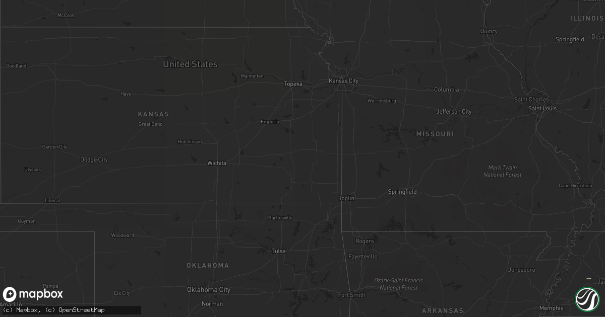
Hail Map in Tennessee on July 10, 2012
Get this storm
July 10 map
$229
one time, instant access
Download today. No call, no setup
Keep the $229
Bought the map and want the full workflow? Apply the entire $229 to a subscription within 7 days. None of it is wasted.
Every map, not just this one
This buys you this map. Subscription and you get every map we run, in the markets you choose from a few cities to whole states to nationwide. Plus real-time alerts the moment a storm fires.
Contact data
Name, contact info, occupancy, even credit band for addresses in the footprint. You go from where it hit to who to call.
Become the source they trust
Unlimited branding weather history reports on demand. You already have the documented answer ready for the property owner, and you are the one who showed up with it.
Property data and RoofTrace estimates
Pull up any address you have got, its value and the exact code rules for that jurisdiction, straight from One Click Code. Then RoofTrace estimates the squares, pitch, and roof value, priced the way you price.
Storm reports in Tennessee
Tennessee
| Date | Description |
|---|---|
| 07/10/20125:30 PM CDT | Dispatch reported a few trees down. |
| 07/10/20124:20 PM CDT | Dispatch reported several trees down. |
| 07/10/20123:20 PM CDT | Dispatch reported several trees down. |
| 07/10/20122:25 PM CDT | Several trees down. |
| 07/10/20122:12 PM CDT | Several trees down |
| 07/10/20121:42 PM CDT | A local report indicates 1.00 inch wind near CLEVELAND |
| 07/10/20121:40 PM CDT | A tree was blown down. Time estimated from radar. |
| 07/10/20121:03 PM CDT | Few trees down. |
| 07/10/201212:25 PM CDT | Couple of trees down. |
All States Impacted by Hail Map on July 10, 2012
Cities Impacted by Hail Map on July 10, 2012
- Madisonville, TN
- Salida, CO
- Kenansville, FL
- Buchanan, GA
- Tallapoosa, GA
- Cedartown, GA
- Newberry, SC
- Silverstreet, SC
- Pomaria, SC
- New Zion, SC
- Hesperus, CO
- Waxhaw, NC
- Brooksville, FL
- Lugoff, SC
- Columbia, SC
- Chester, MT
- Whitlash, MT
- Turbeville, SC
- Reevesville, SC
- Bowman, SC
- Saint George, SC
- Lawton, OK
- Wesley Chapel, FL
- Glen Saint Mary, FL
- Sanderson, FL
- Saint George, GA
- Currie, NC
- Walterboro, SC
- Yemassee, SC
- Homosassa, FL
- Mills, NE
- Gregory, SD
- Antonito, CO
- Lane, SC
- Salters, SC
- Cut Bank, MT
- Green Pond, SC
- Myrtle Beach, SC
- Pinellas Park, FL
- Saint Petersburg, FL
- Axson, GA
- Cache, OK
- Kinards, SC
- Joanna, SC
- Bunnell, FL
- Kingstree, SC
- Sweet Grass, MT
- Sunburst, MT
- Ruffin, SC
- Thermopolis, WY
- Shelby, MT
- Georgetown, SC
- Marietta, GA
- Gastonia, NC
- Hiram, GA
- Tampa, FL
- Clewiston, FL
- Gainesville, FL
- Monroe, NC
- Fort Stockton, TX
- Gainesville, GA
- Grantsboro, NC
- New Bern, NC
- Dallas, GA
- Bishopville, SC
- Fairfax, SC
- Allendale, SC
- Alamosa, CO
- Charlotte, NC
- Pineville, NC
- Matthews, NC
- Fort Mill, SC
- Whitewater, MT
- Hawthorne, FL
- Interlachen, FL
- Jenkinsville, SC
- Chapin, SC
- Little Mountain, SC
- Irmo, SC
- Andrews, SC
- Bristol, FL
- Whitmire, SC
- Atlanta, GA
- Dahlonega, GA
- Dawsonville, GA
- Murrayville, GA
- Dillon, SC
- Pierson, FL
- Saint Stephen, SC
- Jamestown, SC
- Bonneau, SC
- Waycross, GA
- Ridgeway, SC
- Winnsboro, SC
- Reliance, TN
- Old Fort, TN
- Seagrove, NC
- Robbins, NC
- Star, NC
- Dryden, TX
- Biscoe, NC
- Troy, NC
- Eagle Springs, NC
- New Port Richey, FL
- Odessa, FL
- Elgin, SC
- Decatur, GA
- Blackwell, TX
- Lutz, FL
- East Palatka, FL
- Brooker, FL
- Aberdeen, NC
- Riceville, TN
- Calhoun, TN
- Etowah, TN
- Athens, TN
- Charleston, TN
- Delano, TN
- Galata, MT
- Towaoc, CO
- Maryville, TN
- Polkton, NC
- Wadesboro, NC
- Bamberg, SC
- Comer, GA
- Danielsville, GA
- Aiken, SC
- Belmont, NC
- Harrison, TN
- Ooltewah, TN
- Magnolia, NC
- Rose Hill, NC
- Ellerbe, NC
- Marston, NC
- Pendleton, SC
- Florahome, FL
- Mableton, GA
- Oldsmar, FL
- Millwood, GA
- Marietta, SC
- Castle Hayne, NC
- Timmonsville, SC
- Abilene, TX
- Hastings, FL
- Dripping Springs, TX
- Johnson City, TX
- Round Mountain, TX
- Branchville, SC
- Beulaville, NC
- Barksdale, TX
- Mosca, CO
- Brownsville, TN
- Oriental, NC
- Arapahoe, NC
- Polson, MT
- Cassatt, SC
- Bethune, SC
- Sula, MT
- Elloree, SC
- Cameron, SC
- Lithonia, GA
- Stone Mountain, GA
- Scranton, SC
- Olanta, SC
- Quincy, FL
- Chattahoochee, FL
- Punta Gorda, FL
- Ocala, FL
- Ehrhardt, SC
- Venice, FL
- Santee, SC
- Pickens, SC
- Gunnison, CO
- Clayton, AL
- Alma, GA
- Nicholls, GA
- Dade City, FL
- San Antonio, FL
- Easley, SC
- Sunset, SC
- Lynchburg, SC
- Conway, SC
- Webster, FL
- Palmetto, FL
- Denmark, SC
- Olar, SC
- Gatlinburg, TN
- Cosby, TN
- Cape Coral, FL
- Pipe Creek, TX
- Bandera, TX
- Round O, SC
- Atoka, OK
- Lane, OK
- Hemingway, SC
- Medicine Bow, WY
- Anderson, SC
- Ledger, MT
- Riverview, FL
- Hubert, NC
- Havelock, NC
- Temple, GA
- Peachtree Corners, GA
- Smyrna, GA
- Lakemont, GA
- Tiger, GA
- Lexington, SC
- Clayton, GA
- Camden, SC
- Dalzell, SC
- Sumter, SC
- Rembert, SC
- Estero, FL
- Fort Myers, FL
- Wilmington, NC
- Candor, NC
- Duluth, GA
- Camp Wood, TX
- Loris, SC
- Lamar, SC
- Effingham, SC
- Lehigh Acres, FL
- Early Branch, SC
- Varnville, SC
- Macclenny, FL
- Blythewood, SC
- Girard, GA
- Clinton, SC
- Little Rock, SC
- Manning, SC
- Austell, GA
- McDonald, TN
- Cleveland, SC
- Blanding, UT
- Bremen, GA
- Union, SC
- Brevard, NC
- Rochelle, GA
- Abbeville, GA


