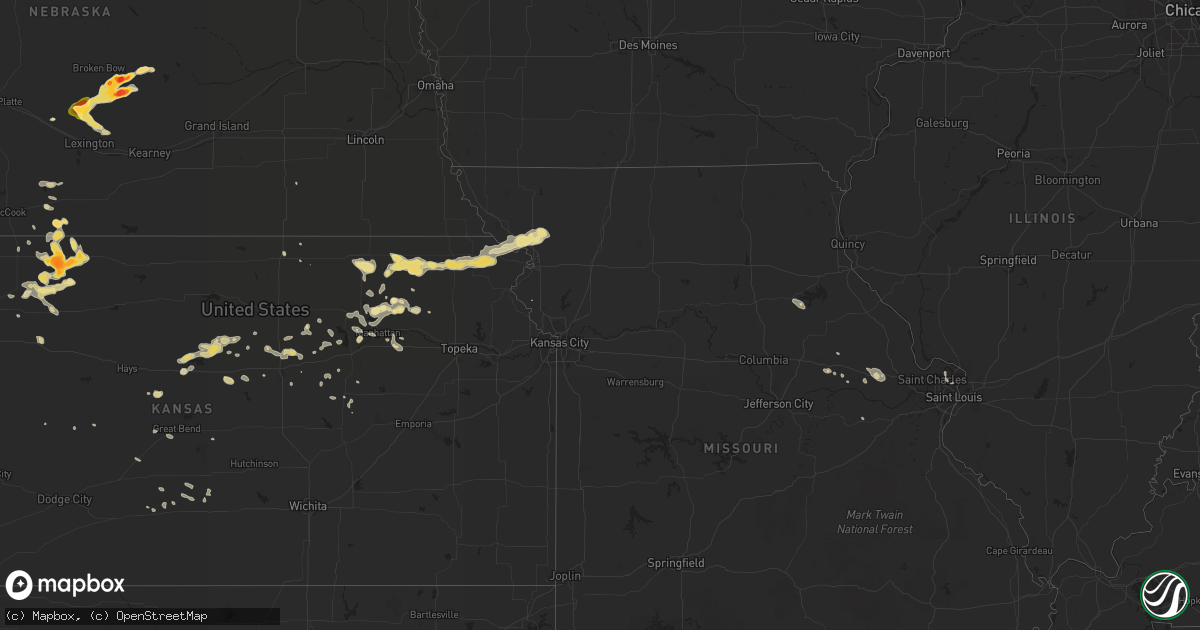
Hail Map in South Dakota on July 9, 2013
Get this storm
July 9 map
$229
one time, instant access
Download today. No call, no setup
Keep the $229
Bought the map and want the full workflow? Apply the entire $229 to a subscription within 7 days. None of it is wasted.
Every map, not just this one
This buys you this map. Subscription and you get every map we run, in the markets you choose from a few cities to whole states to nationwide. Plus real-time alerts the moment a storm fires.
Contact data
Name, contact info, occupancy, even credit band for addresses in the footprint. You go from where it hit to who to call.
Become the source they trust
Unlimited branding weather history reports on demand. You already have the documented answer ready for the property owner, and you are the one who showed up with it.
Property data and RoofTrace estimates
Pull up any address you have got, its value and the exact code rules for that jurisdiction, straight from One Click Code. Then RoofTrace estimates the squares, pitch, and roof value, priced the way you price.
Storm reports in South Dakota
South Dakota
| Date | Description |
|---|---|
| 07/09/20136:58 PM CDT | Nssl shave report. |
| 07/09/20136:55 PM CDT | Quarter size hail. Bean field destroyed. |
| 07/09/20136:50 PM CDT | Intersection of hiways 281 and 10 ping pong hail with 45 mph winds. |
| 07/09/20136:50 PM CDT | Intersection of hiways 281 and 10 ping pong hail with 45 mph winds. |
| 07/09/20136:46 PM CDT | Corn flattened by strong thunderstorm winds |
| 07/09/20136:38 PM CDT | A local report indicates 1.00 inch wind near 6 E SPRING CREEK COLONY |
| 07/08/20138:15 PM CDT | A local report indicates 60 MPH wind near 3 E LILY |
| 07/08/20138:00 PM CDT | Deputy reports brief quater to ping pong size hail. |
| 07/08/20137:42 PM CDT | Quarter size hail and 50 mph winds. |
| 07/08/20137:35 PM CDT | Nssl shave report. |
| 07/08/20137:34 PM CDT | Brown co em |
| 07/08/20137:32 PM CDT | Brown county em |
| 07/08/20137:30 PM CDT | Nssl shave report. |
| 07/08/20137:23 PM CDT | Groton fire dept quarter hail. |
| 07/08/20137:15 PM CDT | Nssl shave report. |
| 07/08/20137:10 PM CDT | Nssl shave report. |
| 07/08/20137:05 PM CDT | Nssl shave report. |
| 07/08/20137:05 PM CDT | A local report indicates 2.75 inch wind near 1 N COLUMBIA |
| 07/08/20137:01 PM CDT | Broken windows on house. Nssl shave report. |
All States Impacted by Hail Map on July 9, 2013
Cities Impacted by Hail Map on July 9, 2013
- Norton, KS
- Center, ND
- Stanton, ND
- Wilsonville, NE
- Washburn, IL
- Varna, IL
- Lacon, IL
- Wishek, ND
- Lehr, ND
- White Pigeon, MI
- Raleigh, NC
- Fuquay Varina, NC
- Shipshewana, IN
- Macksville, KS
- Potter, NE
- Sylvan Grove, KS
- Lincoln, KS
- Holyoke, CO
- Granger, IN
- Edwardsburg, MI
- Elkhart, IN
- Napoleon, OH
- Liberty Center, OH
- Moffit, ND
- Sterling, ND
- Bismarck, ND
- Menoken, ND
- Cambridge, NE
- Bronson, MI
- Fremont, IN
- Coldwater, MI
- Lamont, FL
- Greenville, FL
- Goff, KS
- Seneca, KS
- Columbia, SD
- Bristol, IN
- Raymond, KS
- Bisbee, AZ
- Hereford, AZ
- Ashley, ND
- Yoder, WY
- Jennings, KS
- Clayton, KS
- Westport, SD
- Horton, KS
- Fairview, KS
- Hiawatha, KS
- Powhattan, KS
- Sabetha, KS
- Andover, SD
- Groton, SD
- Bath, SD
- Bernalillo, NM
- Lenora, KS
- Norcatur, KS
- Beulah, ND
- Marysville, KS
- Blue Rapids, KS
- Waterville, KS
- Chapman, KS
- Junction City, KS
- Wallace, KS
- Sumner, NE
- Mason City, NE
- Eddyville, NE
- Ansley, NE
- Broken Bow, NE
- Lexington, NE
- Arcadia, NE
- Oconto, NE
- Baileyville, KS
- Beattie, KS
- Corning, KS
- Centralia, KS
- Frankfort, KS
- Axtell, KS
- Vermillion, KS
- Atwood, KS
- Live Oak, FL
- Hazen, ND
- New Salem, ND
- Galesburg, MI
- Moorefield, NE
- Eustis, NE
- Holbrook, NE
- Kintyre, ND
- Ludell, KS
- Mankato, MN
- Kasota, MN
- Baxley, GA
- Harrisburg, NE
- Florissant, MO
- Saint Louis, MO
- Gothenburg, NE
- New Florence, MO
- South Bend, IN
- New Carlisle, IN
- Forbes, ND
- Socorro, NM
- Davidson, NC
- Mooresville, NC
- Oakley, KS
- Colby, KS
- Saint Cloud, MN
- Clearwater, MN
- Kilkenny, MN
- Olsburg, KS
- Loup City, NE
- Bennington, KS
- Solomon, KS
- Truesdale, MO
- Warrenton, MO
- Wright City, MO
- Savannah, MO
- Amazonia, MO
- Highland, KS
- Fillmore, MO
- Oregon, MO
- Nogales, AZ
- Leola, SD
- Lowpoint, IL
- Roanoke, IL
- Monument, KS
- Russell, KS
- Otis, KS
- Olmitz, KS
- Hoisington, KS
- Barnard, SD
- Frederick, SD
- Houghton, SD
- Sidney, NE
- Gurley, NE
- Rutland, IL
- Wenona, IL
- Ancona, IL
- Dana, IL
- Lyman, NE
- Gering, NE
- Ellsworth, KS
- Oberlin, KS
- East Haddam, CT
- Randolph, KS
- Lucas, KS
- Bunker Hill, KS
- Barnard, KS
- Luray, KS
- Bristol, SD
- Westmoreland, KS
- Millersburg, IN
- Topeka, IN
- Apex, NC
- Wapakoneta, OH
- Hendley, NE
- Haviland, KS
- Troutman, NC
- Dresden, KS
- Selden, KS
- Morland, KS
- Darlington, SC
- Hartsville, SC
- Carthage, NC
- West End, NC
- Eagle Springs, NC
- Hanover, KS
- Leesburg, OH
- New Vienna, OH
- Ypsilanti, MI
- Burdick, KS
- Leesville, SC
- Riley, KS
- Bellefontaine, OH
- Zanesfield, OH
- Minneapolis, KS
- Vandalia, MI
- Cassopolis, MI
- Mandan, ND
- Hope, KS
- Enterprise, KS
- Edgeley, ND
- Kulm, ND
- Fredonia, ND
- Elgin, AZ
- Sonoita, AZ
- Metamora, IL
- Chillicothe, IL
- Benson, IL
- Groveport, OH
- Belleville, KS
- Metamora, OH
- Jasper, MI
- Blissfield, MI
- Napoleon, ND
- Winona, KS
- Toluca, IL
- Cold Spring, MN
- Becker, MN
- Albuquerque, NM
- Tijeras, NM
- Lima, OH
- Corrales, NM
- Miami, AZ
- Globe, AZ
- Peridot, AZ
- Springfield, OH
- Assaria, KS
- Gypsum, KS
- Wamego, KS
- Hoxie, KS
- Wetmore, KS
- Robinson, KS
- Everest, KS
- Troy, KS
- Hillsboro, OH
- Lynchburg, OH
- Manhattan, KS
- Green Springs, OH
- Tiffin, OH
- Longford, KS
- Onaga, KS
- Zap, ND
- Litchfield, NE
- Overton, NE
- Fort Riley, KS
- Ogden, KS
- Hamilton, OH
- Middletown, OH
- Monroe, OH
- Ness City, KS
- Nicholls, GA
- Johnson, KS
- Belen, NM
- Quinter, KS
- Webster, SD
- Waggoner, IL
- Harvel, IL
- Raymond, IL
- Union, MI
- Holly Springs, NC
- Garner, NC
- Willow Spring, NC
- Haddam, KS
- Buchanan, MI
- Houlton, WI
- Hudson, WI
- Corning, OH
- Crooksville, OH
- Trenton, OH
- Callaway, NE
- Leslie, MO
- Alma, KS
- Amherst, CO
- Wray, CO
- Mitchell, NE
- Union Grove, WI
- Saint Paul, MN
- Torrington, WY
- Algodones, NM
- Placitas, NM
- Pimento, IN
- Liberty, IL
- Barry, IL
- Martinsville, IN
- Paragon, IN
- Concord, NC
- El Paso, IL
- Minneapolis, MN
- Sunbury, OH
- Montgomery City, MO
- Upper Sandusky, OH
- Herington, KS
- Cleveland, GA
- Rea, MO
- Rosendale, MO
- Steinhatchee, FL
- Stafford, KS
- Lakeland, MN
- Stillwater, MN
- Fillmore, IL
- Ramsey, IL
- White Cloud, KS
- Hahira, GA
- Lexington, SC
- Lincolnville, KS
- McNeal, AZ
- Patagonia, AZ
- Mountainair, NM
- Martinsville, OH
- Midland, OH
- Tarboro, NC
- Marcellus, MI
- Decatur, MI
- Paris, MO
- Union, MO
- Hickory, NC
- Cochise, AZ
- Milan, MI
- Maybee, MI
- Circleville, OH
- Stoutsville, OH
- Talmage, KS
- Abilene, KS
- Kershaw, SC
- Bethune, SC
- Veteran, WY
- Bartley, NE
- Raymond, OH
- East Liberty, OH
- Mount Auburn, IA
- Vinton, IA
- Brandon, IA
- Tescott, KS
- Salina, KS
- Bayard, NE
- Marysville, OH
- Leonardville, KS
- Lilesville, NC
- Delta, OH
- Lyons, OH
- Clay Center, KS
- Turon, KS
- Iuka, KS
- Athens, GA
- Rio Rico, AZ
- Cross Hill, SC
- Greenwood, SC
- Glenwood City, WI
- Downing, WI
- McCormick, SC
- Kalamazoo, MI
- Pawnee Rock, KS
- Garfield, KS
- Larned, KS
- Ulysses, KS
- Sidney, OH
- Elfrida, AZ
- White City, KS
- Ramona, KS
- Lamar, SC
- Timmonsville, SC
- Pine Knot, KY
- Strunk, KY
- Cuba, KS
- Narka, KS
- Emmett, KS
- Delia, KS
- Bayport, MN
- Hermann, MO
- Canal Winchester, OH
- Willernie, MN
- Lake Elmo, MN
- Perry, FL
- Weston, MO
- Mount Sterling, OH
- Williamsport, OH
- Niles, MI
- Penokee, KS
- Lawton, MI
- Granville, OH
- Alexandria, OH
- Morganton, NC
- Willcox, AZ
- Hodges, SC
- Anna, OH
- Botkins, OH
- Fostoria, OH
- Forest City, MO
- Gilbert, SC
- Grinnell, KS
- Goodland, KS
- Santa Fe, MO
- West Mansfield, OH
- Cincinnati, OH
- Whitley City, KY
- Wakefield, KS
- Kimball, MN
- Great Bend, KS
- Plymouth, MI
- Canton, MI
- Tallahassee, FL
- Jackson, MI
- Parma, MI
- Pataskala, OH
- Ashville, OH
- Claxton, GA
- Union Star, MO
- Dorrance, KS
- Pratt, KS
- Prosperity, SC
- Ohiowa, NE
- Hugo, MN
- New Riegel, OH
- Claremont, SD
- Buckland, OH
- New Knoxville, OH
- Saint Marys, OH
- Kenton, OH
- Danbury, NE
- Frankfort, OH
- Cory, IN
- Alma, GA
- Brookville, KS
- Plain City, OH
- Beverly, KS
- Watkinsville, GA
- Blacklick, OH
- Newark, OH
- Huntsville, OH
- Lewistown, OH
- Long Point, IL
- La Rose, IL
- Minonk, IL
- Fort Loramie, OH
- Minster, OH
- Clear Lake, MN
- Ann Arbor, MI
- Clermont, GA
- Haxtun, CO
- Fremont, OH
- Annandale, MN
- South Haven, MN
- Beeler, KS
- Aberdeen, SD
- Middlebury, IN
- Springfield, GA
- Cozad, NE
- Taylorsville, NC


