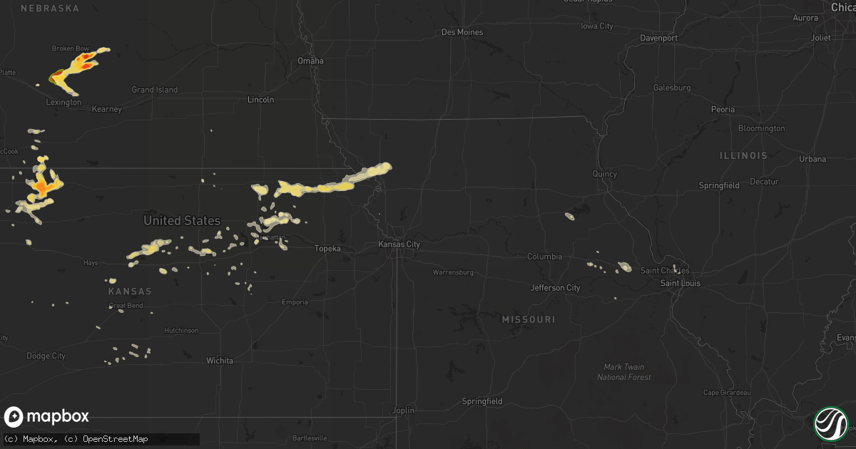
Hail Map in Kansas on July 9, 2013
Get this storm
July 9 map
$229
one time, instant access
Download today. No call, no setup
Keep the $229
Bought the map and want the full workflow? Apply the entire $229 to a subscription within 7 days. None of it is wasted.
Every map, not just this one
This buys you this map. Subscription and you get every map we run, in the markets you choose from a few cities to whole states to nationwide. Plus real-time alerts the moment a storm fires.
Contact data
Name, contact info, occupancy, even credit band for addresses in the footprint. You go from where it hit to who to call.
Become the source they trust
Unlimited branding weather history reports on demand. You already have the documented answer ready for the property owner, and you are the one who showed up with it.
Property data and RoofTrace estimates
Pull up any address you have got, its value and the exact code rules for that jurisdiction, straight from One Click Code. Then RoofTrace estimates the squares, pitch, and roof value, priced the way you price.
Storm reports in Kansas
Kansas
| Date | Description |
|---|---|
| 07/09/20136:50 PM CDT | Late report. Roof blown off of a grainery and metal feeders damaged. Large tree limbs down. Power poles and power lines down. Time estimated. |
| 07/09/20136:50 PM CDT | Nickel to quarter size hail. |
| 07/09/20135:35 PM CDT | The kansas highway patrol reported a semitrailer was blown over on highway 96 and mile marker 100. |
| 07/09/20131:00 AM CDT | Winds 35 to 40 mph. Hail fell for 15 minutes ranging from peas to quarter size. |
| 07/09/201312:54 AM CDT | A local report indicates 1.00 inch wind near 5 SSW POWHATTAN |
| 07/08/201310:35 PM CDT | 1 to 2 inch diameter tree limbs down. Wind gusts estimated around 50 to 60 mph. |
| 07/08/201310:25 PM CDT | A local report indicates 60 MPH wind near 5 W COUNCIL GROVE |
| 07/08/201310:10 PM CDT | Time estimated based on radar. Report via social media. |
| 07/08/201310:10 PM CDT | Time estimated based on radar. Report via social media. |
| 07/08/20139:25 PM CDT | A local report indicates 70 MPH wind near WSW CULVER |
| 07/08/20139:23 PM CDT | A local report indicates 1.00 inch wind near 4 E BENNINGTON |
| 07/08/20139:10 PM CDT | Lasted for 5 mins |
| 07/08/20139:07 PM CDT | A local report indicates 60 MPH wind near GLENDALE |
| 07/08/20138:52 PM CDT | Tree branches one inch or less in diameter were down. Delyaed report. |
| 07/08/20138:45 PM CDT | Hail quarter to half dollar size. Estimated wind gust of 60 mph. |
| 07/08/20138:38 PM CDT | A local report indicates 60 MPH wind near 2 S SYLVAN GROVE |
| 07/08/20138:35 PM CDT | Strong winds also were reported. No wind speed estimate. |
| 07/08/20138:30 PM CDT | A local report indicates 1.25 inch wind near NORTON |
| 07/08/20138:30 PM CDT | Large tree limb down with estimated 60 mph winds. Report via kwch on twitter. |
| 07/08/20138:28 PM CDT | A local report indicates 1.75 inch wind near 1 SW NORTON |
| 07/08/20138:25 PM CDT | A local report indicates 1.25 inch wind near 2 S NORTON |
| 07/08/20138:23 PM CDT | A local report indicates 1.00 inch wind near 1 SW NORTON |
| 07/08/20138:15 PM CDT | Golf ball to baseball size hail reported 6 miles east of clayton. Time estimated from radar. |
| 07/08/20138:13 PM CDT | Wind gusts of 50 to 60 mph. Some small tree limbs down. |
| 07/08/20137:50 PM CDT | Late report. Hail size ranged from pea to quarter size. |
| 07/08/20137:00 PM CDT | Lots of tree limbs down in morland. Most were 3 to 5 inches in diameter but a few were up to 12 inches in diameter. Pea size hail and a grass fire due to a lightning st |
All States Impacted by Hail Map on July 9, 2013
Cities Impacted by Hail Map on July 9, 2013
- Norton, KS
- Center, ND
- Stanton, ND
- Wilsonville, NE
- Washburn, IL
- Varna, IL
- Lacon, IL
- Wishek, ND
- Lehr, ND
- White Pigeon, MI
- Raleigh, NC
- Fuquay Varina, NC
- Shipshewana, IN
- Macksville, KS
- Potter, NE
- Sylvan Grove, KS
- Lincoln, KS
- Holyoke, CO
- Granger, IN
- Edwardsburg, MI
- Elkhart, IN
- Napoleon, OH
- Liberty Center, OH
- Moffit, ND
- Sterling, ND
- Bismarck, ND
- Menoken, ND
- Cambridge, NE
- Bronson, MI
- Fremont, IN
- Coldwater, MI
- Lamont, FL
- Greenville, FL
- Goff, KS
- Seneca, KS
- Columbia, SD
- Bristol, IN
- Raymond, KS
- Bisbee, AZ
- Hereford, AZ
- Ashley, ND
- Yoder, WY
- Jennings, KS
- Clayton, KS
- Westport, SD
- Horton, KS
- Fairview, KS
- Hiawatha, KS
- Powhattan, KS
- Sabetha, KS
- Andover, SD
- Groton, SD
- Bath, SD
- Bernalillo, NM
- Lenora, KS
- Norcatur, KS
- Beulah, ND
- Marysville, KS
- Blue Rapids, KS
- Waterville, KS
- Chapman, KS
- Junction City, KS
- Wallace, KS
- Sumner, NE
- Mason City, NE
- Eddyville, NE
- Ansley, NE
- Broken Bow, NE
- Lexington, NE
- Arcadia, NE
- Oconto, NE
- Baileyville, KS
- Beattie, KS
- Corning, KS
- Centralia, KS
- Frankfort, KS
- Axtell, KS
- Vermillion, KS
- Atwood, KS
- Live Oak, FL
- Hazen, ND
- New Salem, ND
- Galesburg, MI
- Moorefield, NE
- Eustis, NE
- Holbrook, NE
- Kintyre, ND
- Ludell, KS
- Mankato, MN
- Kasota, MN
- Baxley, GA
- Harrisburg, NE
- Florissant, MO
- Saint Louis, MO
- Gothenburg, NE
- New Florence, MO
- South Bend, IN
- New Carlisle, IN
- Forbes, ND
- Socorro, NM
- Davidson, NC
- Mooresville, NC
- Oakley, KS
- Colby, KS
- Saint Cloud, MN
- Clearwater, MN
- Kilkenny, MN
- Olsburg, KS
- Loup City, NE
- Bennington, KS
- Solomon, KS
- Truesdale, MO
- Warrenton, MO
- Wright City, MO
- Savannah, MO
- Amazonia, MO
- Highland, KS
- Fillmore, MO
- Oregon, MO
- Nogales, AZ
- Leola, SD
- Lowpoint, IL
- Roanoke, IL
- Monument, KS
- Russell, KS
- Otis, KS
- Olmitz, KS
- Hoisington, KS
- Barnard, SD
- Frederick, SD
- Houghton, SD
- Sidney, NE
- Gurley, NE
- Rutland, IL
- Wenona, IL
- Ancona, IL
- Dana, IL
- Lyman, NE
- Gering, NE
- Ellsworth, KS
- Oberlin, KS
- East Haddam, CT
- Randolph, KS
- Lucas, KS
- Bunker Hill, KS
- Barnard, KS
- Luray, KS
- Bristol, SD
- Westmoreland, KS
- Millersburg, IN
- Topeka, IN
- Apex, NC
- Wapakoneta, OH
- Hendley, NE
- Haviland, KS
- Troutman, NC
- Dresden, KS
- Selden, KS
- Morland, KS
- Darlington, SC
- Hartsville, SC
- Carthage, NC
- West End, NC
- Eagle Springs, NC
- Hanover, KS
- Leesburg, OH
- New Vienna, OH
- Ypsilanti, MI
- Burdick, KS
- Leesville, SC
- Riley, KS
- Bellefontaine, OH
- Zanesfield, OH
- Minneapolis, KS
- Vandalia, MI
- Cassopolis, MI
- Mandan, ND
- Hope, KS
- Enterprise, KS
- Edgeley, ND
- Kulm, ND
- Fredonia, ND
- Elgin, AZ
- Sonoita, AZ
- Metamora, IL
- Chillicothe, IL
- Benson, IL
- Groveport, OH
- Belleville, KS
- Metamora, OH
- Jasper, MI
- Blissfield, MI
- Napoleon, ND
- Winona, KS
- Toluca, IL
- Cold Spring, MN
- Becker, MN
- Albuquerque, NM
- Tijeras, NM
- Lima, OH
- Corrales, NM
- Miami, AZ
- Globe, AZ
- Peridot, AZ
- Springfield, OH
- Assaria, KS
- Gypsum, KS
- Wamego, KS
- Hoxie, KS
- Wetmore, KS
- Robinson, KS
- Everest, KS
- Troy, KS
- Hillsboro, OH
- Lynchburg, OH
- Manhattan, KS
- Green Springs, OH
- Tiffin, OH
- Longford, KS
- Onaga, KS
- Zap, ND
- Litchfield, NE
- Overton, NE
- Fort Riley, KS
- Ogden, KS
- Hamilton, OH
- Middletown, OH
- Monroe, OH
- Ness City, KS
- Nicholls, GA
- Johnson, KS
- Belen, NM
- Quinter, KS
- Webster, SD
- Waggoner, IL
- Harvel, IL
- Raymond, IL
- Union, MI
- Holly Springs, NC
- Garner, NC
- Willow Spring, NC
- Haddam, KS
- Buchanan, MI
- Houlton, WI
- Hudson, WI
- Corning, OH
- Crooksville, OH
- Trenton, OH
- Callaway, NE
- Leslie, MO
- Alma, KS
- Amherst, CO
- Wray, CO
- Mitchell, NE
- Union Grove, WI
- Saint Paul, MN
- Torrington, WY
- Algodones, NM
- Placitas, NM
- Pimento, IN
- Liberty, IL
- Barry, IL
- Martinsville, IN
- Paragon, IN
- Concord, NC
- El Paso, IL
- Minneapolis, MN
- Sunbury, OH
- Montgomery City, MO
- Upper Sandusky, OH
- Herington, KS
- Cleveland, GA
- Rea, MO
- Rosendale, MO
- Steinhatchee, FL
- Stafford, KS
- Lakeland, MN
- Stillwater, MN
- Fillmore, IL
- Ramsey, IL
- White Cloud, KS
- Hahira, GA
- Lexington, SC
- Lincolnville, KS
- McNeal, AZ
- Patagonia, AZ
- Mountainair, NM
- Martinsville, OH
- Midland, OH
- Tarboro, NC
- Marcellus, MI
- Decatur, MI
- Paris, MO
- Union, MO
- Hickory, NC
- Cochise, AZ
- Milan, MI
- Maybee, MI
- Circleville, OH
- Stoutsville, OH
- Talmage, KS
- Abilene, KS
- Kershaw, SC
- Bethune, SC
- Veteran, WY
- Bartley, NE
- Raymond, OH
- East Liberty, OH
- Mount Auburn, IA
- Vinton, IA
- Brandon, IA
- Tescott, KS
- Salina, KS
- Bayard, NE
- Marysville, OH
- Leonardville, KS
- Lilesville, NC
- Delta, OH
- Lyons, OH
- Clay Center, KS
- Turon, KS
- Iuka, KS
- Athens, GA
- Rio Rico, AZ
- Cross Hill, SC
- Greenwood, SC
- Glenwood City, WI
- Downing, WI
- McCormick, SC
- Kalamazoo, MI
- Pawnee Rock, KS
- Garfield, KS
- Larned, KS
- Ulysses, KS
- Sidney, OH
- Elfrida, AZ
- White City, KS
- Ramona, KS
- Lamar, SC
- Timmonsville, SC
- Pine Knot, KY
- Strunk, KY
- Cuba, KS
- Narka, KS
- Emmett, KS
- Delia, KS
- Bayport, MN
- Hermann, MO
- Canal Winchester, OH
- Willernie, MN
- Lake Elmo, MN
- Perry, FL
- Weston, MO
- Mount Sterling, OH
- Williamsport, OH
- Niles, MI
- Penokee, KS
- Lawton, MI
- Granville, OH
- Alexandria, OH
- Morganton, NC
- Willcox, AZ
- Hodges, SC
- Anna, OH
- Botkins, OH
- Fostoria, OH
- Forest City, MO
- Gilbert, SC
- Grinnell, KS
- Goodland, KS
- Santa Fe, MO
- West Mansfield, OH
- Cincinnati, OH
- Whitley City, KY
- Wakefield, KS
- Kimball, MN
- Great Bend, KS
- Plymouth, MI
- Canton, MI
- Tallahassee, FL
- Jackson, MI
- Parma, MI
- Pataskala, OH
- Ashville, OH
- Claxton, GA
- Union Star, MO
- Dorrance, KS
- Pratt, KS
- Prosperity, SC
- Ohiowa, NE
- Hugo, MN
- New Riegel, OH
- Claremont, SD
- Buckland, OH
- New Knoxville, OH
- Saint Marys, OH
- Kenton, OH
- Danbury, NE
- Frankfort, OH
- Cory, IN
- Alma, GA
- Brookville, KS
- Plain City, OH
- Beverly, KS
- Watkinsville, GA
- Blacklick, OH
- Newark, OH
- Huntsville, OH
- Lewistown, OH
- Long Point, IL
- La Rose, IL
- Minonk, IL
- Fort Loramie, OH
- Minster, OH
- Clear Lake, MN
- Ann Arbor, MI
- Clermont, GA
- Haxtun, CO
- Fremont, OH
- Annandale, MN
- South Haven, MN
- Beeler, KS
- Aberdeen, SD
- Middlebury, IN
- Springfield, GA
- Cozad, NE
- Taylorsville, NC


