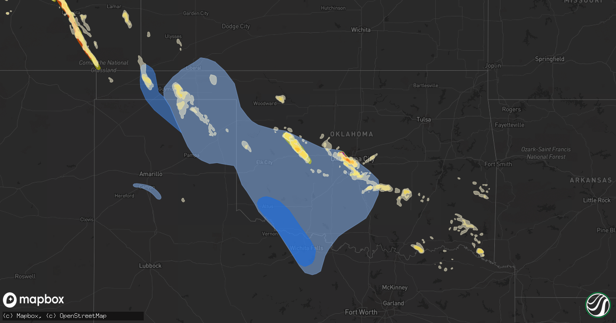
Hail Map in Oklahoma on July 8, 2023
Get this storm
July 8 map
$229
one time, instant access
Download today. No call, no setup
Keep the $229
Bought the map and want the full workflow? Apply the entire $229 to a subscription within 7 days. None of it is wasted.
Every map, not just this one
This buys you this map. Subscription and you get every map we run, in the markets you choose from a few cities to whole states to nationwide. Plus real-time alerts the moment a storm fires.
Contact data
Name, contact info, occupancy, even credit band for addresses in the footprint. You go from where it hit to who to call.
Become the source they trust
Unlimited branding weather history reports on demand. You already have the documented answer ready for the property owner, and you are the one who showed up with it.
Property data and RoofTrace estimates
Pull up any address you have got, its value and the exact code rules for that jurisdiction, straight from One Click Code. Then RoofTrace estimates the squares, pitch, and roof value, priced the way you price.
Storm reports in Oklahoma
Oklahoma
| Date | Description |
|---|---|
| 07/08/20239:40 AM CDT | Large tree and power pole snapped in hodgen via twitter. |
| 07/08/20239:40 AM CDT | Storm spotter approximately 1/4 mile south of hodgen on highway 59 reported large tree branches snapped. All branches that were broken were laying toward the east/south |
| 07/08/20239:38 AM CDT | Report from mping: 3-inch tree limbs broken; power poles broken. |
| 07/08/20234:45 AM CDT | Large tree split down the middle. This tree had been damaged during a previous storm years ago. Facebook report. Time estimated from radar. |
| 07/08/20234:45 AM CDT | Large tree split down the middle. This tree had been damaged duri |
| 07/08/20234:45 AM CDT | Six to nine inch tree branches broken at a couple of locations in town. Time estimated. |
| 07/08/20234:30 AM CDT | 12-inch diameter tree uprooted. Time estimated via radar. |
| 07/08/20234:20 AM CDT | A local report indicates 60 MPH wind near Newcastle |
| 07/08/20234:06 AM CDT | Facebook report with photo of large tree limbs down. Time based on radar. |
| 07/08/20234:05 AM CDT | A local report indicates 58 MPH wind near Hollister |
| 07/08/20233:55 AM CDT | Chickasha municipal airport. |
| 07/08/20233:52 AM CDT | A local report indicates 70 MPH wind near 2 S Moore |
| 07/08/20233:50 AM CDT | A few homes with shingles removed along with a 6–12-inch diameter tree snapped in half near this location. Time estimated via radar. |
| 07/08/20233:50 AM CDT | Corrects previous tstm wnd dmg report from 4 ssw moore. Multiple power poles blown down near this location. Time estimated via radar. |
| 07/08/20233:50 AM CDT | Multiple power poles blown down near this location. Time estimated via radar. |
| 07/08/20233:47 AM CDT | Will rogers world airport. |
| 07/08/20233:45 AM CDT | 12–18-inch diameter tree snapped near the base. Time estimated via radar. |
| 07/08/20233:45 AM CDT | A local report indicates 61 MPH wind near 4 S Tipton |
| 07/08/20233:45 AM CDT | 12-18 inch diameter tree branch blown down. Time estimated via radar. |
| 07/08/20233:45 AM CDT | Photo of wood/metal power lines down across road near sw 149th and penn. Time estimated from tokc radar. |
| 07/08/20233:40 AM CDT | Small tin machine shed destroyed. Time estimated via radar. |
| 07/08/20233:34 AM CDT | A local report indicates 2.75 inch wind near 4 SW Oklahoma City |
| 07/08/20233:30 AM CDT | A local report indicates 77 MPH wind near Altus |
| 07/08/20233:30 AM CDT | A local report indicates 58 MPH wind near 3 SSE Fort Cobb Reservo |
| 07/08/20233:28 AM CDT | Report from mping: tennis ball |
| 07/08/20233:28 AM CDT | A local report indicates 1.75 inch wind near 4 W Valley Brook |
| 07/08/20233:28 AM CDT | Will rogers world airport. |
| 07/08/20233:21 AM CDT | A local report indicates 1.75 inch wind near 3 SSE Bethany |
| 07/08/20233:20 AM CDT | Solar panels blown off the cedar lake fire department building. Time estimated via radar. |
| 07/08/20233:17 AM CDT | A local report indicates 70 MPH wind near Altus Air Force Base |
| 07/08/20233:15 AM CDT | Public called with report. |
| 07/08/20233:10 AM CDT | Center irrigation pivot blown down. Time estimated via radar. |
| 07/08/20233:05 AM CDT | A local report indicates 1.00 inch wind near 3 SSE Yukon |
| 07/08/20233:00 AM CDT | Large tree blown down. Time estimated via radar. |
| 07/08/20232:55 AM CDT | 12-24-inch diameter tree uprooted. Time estimated via radar. |
| 07/08/20232:53 AM CDT | Report from mping: quarter |
| 07/08/20232:48 AM CDT | Kcsm asos. |
| 07/08/20232:34 AM CDT | A local report indicates 1.50 inch wind near 8 SSE Thomas |
| 07/08/20232:34 AM CDT | Report from mping: ping pong ball |
| 07/08/20232:31 AM CDT | Report from mping: quarter |
| 07/08/20232:30 AM CDT | Major roof damage to church youth center near swosu... Many roofs damage in weatherford... Power lines down mainly in northeast side of town. Via kwey. Time estimated. |
| 07/08/20232:25 AM CDT | Several uprooted trees. Facebook post with photo. Time estimated from radar. |
| 07/08/20232:25 AM CDT | Large tree limb and powerlines blown down. Time estimated via radar. |
| 07/08/20232:18 AM CDT | Large trees snapped. Facebook comment with photo. Time estimated from radar. |
| 07/08/20232:10 AM CDT | A local report indicates 60 MPH wind near 5 ENE Dempsey |
| 07/08/20232:05 AM CDT | A local report indicates 59 MPH wind near 3 N Putnam |
| 07/08/20231:57 AM CDT | A local report indicates 1.00 inch wind near 1 SE Norman |
| 07/08/20231:55 AM CDT | A local report indicates 72 MPH wind near 3 N Putnam |
| 07/08/20231:50 AM CDT | Mesonet wind gust. |
| 07/08/20231:40 AM CDT | Report from mping: half dollar |
| 07/08/20231:40 AM CDT | Report from mping: quarter |
| 07/08/20231:40 AM CDT | A local report indicates 58 MPH wind near 8 WSW Arnett |
| 07/07/202311:46 PM CDT | A local report indicates 60 MPH wind near 1 WSW Guymon |
| 07/07/202311:40 PM CDT | A local report indicates 63 MPH wind near 1 SSW Beaver |
| 07/07/202311:30 PM CDT | A local report indicates 58 MPH wind near 1 WSW Hooker |
| 07/07/202311:23 PM CDT | Large tree downed across road. Report submitted with photo. Time estimated from radar. |
All States Impacted by Hail Map on July 8, 2023
Cities Impacted by Hail Map on July 8, 2023
- Idabel, OK
- Valliant, OK
- Winthrop, AR
- Foreman, AR
- Heavener, OK
- Howe, OK
- Haworth, OK
- Broken Bow, OK
- Gwinn, MI
- Hodgen, OK
- Wister, OK
- Rattan, OK
- Snow, OK
- Nashoba, OK
- Vernon, AL
- Sulligent, AL
- Poteau, OK
- Robinson, IL
- Willow Hill, IL
- Flat Rock, IL
- Oblong, IL
- Hot Springs National Park, AR
- West Liberty, IL
- Sardis, MS
- Red Oak, OK
- Claremont, IL
- Little Rock, AR
- Lake Cormorant, MS
- Charlotte, NC
- Heth, AR
- Earle, AR
- Fulton, MS
- Kinta, OK
- Rapid City, SD
- Scottsbluff, NE
- Harrison, NE
- Rock, MI
- Rapid River, MI
- Minatare, NE
- Bayard, NE
- Melbeta, NE
- Gering, NE
- Mcgrew, NE
- Buffalo, WY
- Kaycee, WY
- Harrisburg, NE
- Platteville, CO
- Fort Lupton, CO
- Bridgeport, NE
- Greenbrier, TN
- Springfield, TN
- Goodlettsville, TN
- Haxtun, CO
- Hudson, CO
- Lusk, WY
- Keenesburg, CO
- Hendersonville, TN
- Whites Creek, TN
- Joelton, TN
- Madison, TN
- Holyoke, CO
- Old Hickory, TN
- Nashville, TN
- Yuma, CO
- Wray, CO
- Jay Em, WY
- Morrison, CO
- Littleton, CO
- Denver, CO
- Torrington, WY
- Haigler, NE
- Lone Tree, CO
- Castle Rock, CO
- Parker, CO
- Englewood, CO
- Saint Francis, KS
- Kimball, NE
- Colorado Springs, CO
- Peyton, CO
- Hermitage, TN
- Mount Juliet, TN
- Dix, NE
- Dalton, NE
- Gurley, NE
- Sidney, NE
- Newcastle, WY
- Lance Creek, WY
- Douglas, WY
- Gillette, WY
- Yoder, CO
- Calhan, CO
- Sedgwick, CO
- Fleming, CO
- Paoli, CO
- Rush, CO
- Goodland, KS
- Edson, KS
- Brewster, KS
- Ramah, CO
- Shannon, NC
- Hartford, KY
- Olaton, KY
- Beaver Dam, KY
- Midwest, WY
- Briggsdale, CO
- Carney, MI
- Deatsville, AL
- Marbury, AL
- Hamlet, NC
- Bennett, CO
- Strasburg, CO
- Mitchell, NE
- Wright City, OK
- Snyder, CO
- Escanaba, MI
- Louisville, MS
- Crenshaw, MS
- Powderly, TX
- Arthur City, TX
- Underwood, IN
- Henryville, IN
- Lexington, IN
- Nabb, IN
- Portland, TN
- Golden, CO
- Evergreen, CO
- Idledale, CO
- Indian Hills, CO
- Milan, TN
- Velva, ND
- Upton, WY
- Greeley, CO
- Eaton, CO
- Lucerne, CO
- Galeton, CO
- Ferdinand, IN
- Red Springs, NC
- Santa Rosa, NM
- Pontotoc, MS
- Randolph, MS
- Blue Mountain, MS
- Ripley, MS
- Prattville, AL
- Verbena, AL
- Paris, TX
- Brookston, TX
- Bark River, MI
- Gibbstown, NJ
- Mickleton, NJ
- Berwyn, PA
- Newtown Square, PA
- Malvern, PA
- Abita Springs, LA
- Bush, LA
- Covington, LA
- Madisonville, LA
- Lodgepole, NE
- Chappell, NE
- Bennington, OK
- Bokchito, OK
- Telephone, TX
- Durant, OK
- Ivanhoe, TX
- Columbus, NJ
- Trenton, NJ
- Robbinsville, NJ
- Chesterfield, NJ
- Marks, MS
- Adolphus, KY
- Bowling Green, KY
- Scottsville, KY
- Alvaton, KY
- Champion, NE
- Carriere, MS
- Picayune, MS
- Garvin, OK
- Ringold, OK
- Evanston, IN
- Grandview, IN
- Lamar, IN
- Faunsdale, AL
- Linden, AL
- Perkins, MI
- Cuervo, NM
- Arlington, AL
- Thomaston, AL
- Catherine, AL
- Crook, CO
- Iliff, CO
- Hopkinsville, KY
- Crofton, KY
- Media, PA
- Glen Mills, PA
- Flourtown, PA
- Fort Washington, PA
- Lafayette Hill, PA
- Saint Meinrad, IN
- Santa Claus, IN
- Coosada, AL
- Wetumpka, AL
- Bethpage, TN
- Westmoreland, TN
- Opp, AL
- Ruidoso, NM
- Byers, CO
- Lonoke, AR
- Defuniak Springs, FL
- Nichols, SC
- Boswell, OK
- Atoka, OK
- Pembroke, KY
- Elkton, KY
- Trenton, KY
- Watford City, ND
- Corona, NM
- Live Oak, FL
- Mayo, FL
- Marianna, AR
- Palestine, AR
- Samson, AL
- Coffee Springs, AL
- Deport, TX
- Pattonville, TX
- Charleston, SC
- Clanton, AL
- Elba, AL
- Jack, AL
- English, IN
- Galivants Ferry, SC
- Kinston, AL
- Elmore, AL
- Moro, AR
- Cottontown, TN
- Trenton, TN
- South Hadley, MA
- Granby, MA
- Blossom, TX
- Saginaw, MI
- Batesville, MS
- Olney Springs, CO
- Boone, CO
- Ordway, CO
- Manville, WY
- Lost Springs, WY
- Cheyenne, WY
- Carpenter, WY
- Grover, CO
- Nunn, CO
- Sugar City, CO
- Manzanola, CO
- Rocky Ford, CO
- Swink, CO
- La Junta, CO
- Shawnee, WY
- Glendo, WY
- Orchard, CO
- Las Animas, CO
- Kim, CO
- Weldona, CO
- Karval, CO
- Pritchett, CO
- Canyon, TX
- Wildorado, TX
- Amarillo, TX
- Happy, TX
- Andalusia, AL
- Wing, AL
- Elgin, AZ
- Tucumcari, NM
- Marlborough, NH
- Nelson, NH
- Harrisville, NH
- Voltaire, ND
- Hereford, AZ
- Bisbee, AZ
- New Madrid, MO
- Martinsdale, MT
- Ronda, NC
- Birch Tree, MO
- Alton, MO
- Trementina, NM
- Aynor, SC
- Elizabeth, CO
- Winona, KS
- Monument, KS
- Otis, CO
- Akron, CO
- Lilbourn, MO
- Maxton, NC
- Brush, CO
- Hugo, CO
- Grafton, NH
- Kiowa, CO
- Elbert, CO
- Pueblo, CO
- Conchas Dam, NM
- Evergreen, AL
- Castleberry, AL
- Dayton, TN
- Fountain, CO
- Hartford, AL
- Chancellor, AL
- Enterprise, AL
- Daleville, AL
- Burns, WY
- Hillsdale, WY
- Eckley, CO
- Couch, MO
- Deer Trail, CO
- Franktown, CO
- Oakley, KS
- Rumney, NH
- Wagon Mound, NM
- Myrtle, MO
- Matheson, CO
- Ridgeway, SC
- Troup, TX
- Bosler, WY
- Colby, KS
- Bristol, NH
- Scott City, KS
- Healy, KS
- Newport, NH
- Wheatland, WY
- Garrett, WY
- Gould City, MI
- San Jon, NM
- Grinnell, KS
- Ackerman, MS
- Geneva, AL
- Roxton, TX
- Granada, CO
- Springfield, NH
- Lamar, CO
- Canaan, NH
- Thayer, MO
- Roswell, NM
- Paoli, PA
- Goodwell, OK
- Keyes, OK
- Texhoma, OK
- Elkhart, KS
- Meade, KS
- Canadian, TX
- Mobeetie, TX
- Gruver, TX
- Forgan, OK
- Hugoton, KS
- Hooker, OK
- Kismet, KS
- Turpin, OK
- Laverne, OK
- Hardesty, OK
- Miami, TX
- Arnett, OK
- Tyrone, OK
- Crawford, OK
- Durham, OK
- Cheyenne, OK
- Reydon, OK
- Higgins, TX
- Guymon, OK
- Pampa, TX
- Plains, KS
- Briscoe, TX
- Beaver, OK
- Darrouzett, TX
- Perryton, TX
- Liberal, KS
- Spearman, TX
- Follett, TX
- Stinnett, TX
- Lipscomb, TX
- Gate, OK
- Shattuck, OK
- Balko, OK
- Booker, TX
- Wheeler, TX
- Leedey, OK
- Hammon, OK
- Butler, OK
- Taloga, OK
- Oakwood, OK
- Fay, OK
- Watonga, OK
- Putnam, OK
- Gage, OK
- Camargo, OK
- Vici, OK
- Canton, OK
- Shamrock, TX
- Sweetwater, OK
- Sayre, OK
- Elk City, OK
- Custer City, OK
- Thomas, OK
- Clinton, OK
- Norman, OK
- Noble, OK
- Texola, OK
- Erick, OK
- Canute, OK
- Carter, OK
- Willow, OK
- Weatherford, OK
- Geary, OK
- Yukon, OK
- Oklahoma City, OK
- Bethany, OK
- Wheatland, OK
- Hydro, OK
- Lookeba, OK
- Hinton, OK
- Cordell, OK
- Rocky, OK
- Gotebo, OK
- Corn, OK
- Sentinel, OK
- Bessie, OK
- Foss, OK
- Granite, OK
- Hobart, OK
- Arapaho, OK
- Lone Wolf, OK
- Roosevelt, OK
- Colony, OK
- Mountain View, OK
- Dill City, OK
- Carnegie, OK
- Gracemont, OK
- Fort Cobb, OK
- Lawton, OK
- Medicine Park, OK
- Greenfield, OK
- Calumet, OK
- Apache, OK
- Binger, OK
- Elgin, OK
- Anadarko, OK
- Tuttle, OK
- Chickasha, OK
- Union City, OK
- Okarche, OK
- Piedmont, OK
- Minco, OK
- El Reno, OK
- Verden, OK
- Cyril, OK
- Mustang, OK
- Amber, OK
- Pocasset, OK
- Mangum, OK
- Blair, OK
- Olustee, OK
- Headrick, OK
- Altus, OK
- Mountain Park, OK
- Altus Afb, OK
- Vinson, OK
- Hollis, OK
- Gould, OK
- Duke, OK
- Eldorado, OK
- Vernon, TX
- Elmer, OK
- Odell, TX
- Snyder, OK
- Frederick, OK
- Tipton, OK
- Chattanooga, OK
- Marlow, OK
- Loveland, OK
- Cache, OK
- Fletcher, OK
- Geronimo, OK
- Fort Sill, OK
- Hollister, OK
- Indiahoma, OK
- Ninnekah, OK
- Rush Springs, OK
- Walters, OK
- Faxon, OK
- Cement, OK
- Newcastle, OK
- Alex, OK
- Blanchard, OK
- Lindsay, OK
- Duncan, OK
- Bradley, OK
- Washington, OK
- Davidson, OK
- Grandfield, OK
- Randlett, OK
- Devol, OK
- Stratford, TX
- Texhoma, TX
- Byers, TX
- Celina, TX
- Temple, OK
- Saint Jo, TX
- Muenster, TX
- Waurika, OK
- Mckinney, TX
- Ryan, OK
- Nocona, TX
- Pilot Point, TX
- Gainesville, TX
- Hastings, OK
- Lindsay, TX
- Valley View, TX
- Maysville, OK
- Purcell, OK
- Wayne, OK
- Lexington, OK
- Macomb, OK
- Tecumseh, OK
- Wanette, OK
- Newalla, OK
- Iowa Park, TX
- Harrold, TX
- Holliday, TX
- Wichita Falls, TX
- Oklaunion, TX
- Burkburnett, TX
- Electra, TX
- Sheppard Afb, TX
- Scotland, TX
- Petrolia, TX
- Archer City, TX
- Henrietta, TX
- Windthorst, TX
- Comanche, OK
- Loco, OK
- Ringling, OK
- Pauls Valley, OK
- Elmore City, OK
- Hennepin, OK
- Healdton, OK
- Foster, OK
- Ratliff City, OK
- Graham, OK
- Tussy, OK
- Byars, OK
- Asher, OK
- Paoli, OK
- Bryson, TX
- Perrin, TX
- Olney, TX
- Bellevue, TX
- Ringgold, TX
- Bowie, TX
- Terral, OK
- Jacksboro, TX
- Springer, OK
- Stratford, OK
- Wynnewood, OK
- Davis, OK
- Wilson, OK
- Boise City, OK
- Mooreland, OK
- Amherst, MA
- Walsh, CO
- Ault, CO
- Ulysses, KS
- Quitaque, TX
- Allen, OK
- Harrah, OK
- Mcloud, OK
- Calvin, OK
- Moscow, KS
- Fort Towson, OK
- Ada, OK
- Tupelo, OK
- Stonewall, OK
- Kingfisher, OK
- Holly, CO
- Atwood, OK
- Omega, OK
- Manter, KS
- Konawa, OK
- Kiowa, OK
- Choctaw, OK
- Sasakwa, OK
- Stuart, OK
- Mcalester, OK
- Seiling, OK
- Meeker, OK
- Wardville, OK
- Holdenville, OK


