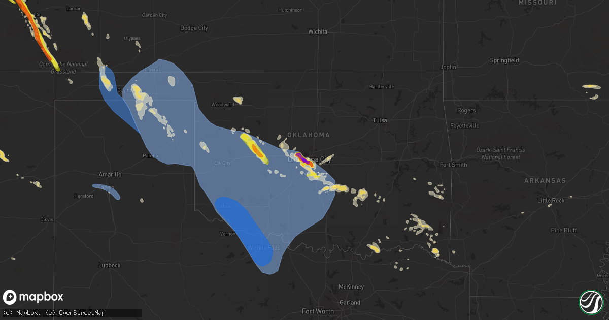
Hail Map on July 8, 2023
Get this storm
July 8 map
$229
one time, instant access
Download today. No call, no setup
Keep the $229
Bought the map and want the full workflow? Apply the entire $229 to a subscription within 7 days. None of it is wasted.
Every map, not just this one
This buys you this map. Subscription and you get every map we run, in the markets you choose from a few cities to whole states to nationwide. Plus real-time alerts the moment a storm fires.
Contact data
Name, contact info, occupancy, even credit band for addresses in the footprint. You go from where it hit to who to call.
Become the source they trust
Unlimited branding weather history reports on demand. You already have the documented answer ready for the property owner, and you are the one who showed up with it.
Property data and RoofTrace estimates
Pull up any address you have got, its value and the exact code rules for that jurisdiction, straight from One Click Code. Then RoofTrace estimates the squares, pitch, and roof value, priced the way you price.
States Impacted by Hail Map on July 8, 2023
Storm reports
Tennessee
| Date | Description |
|---|---|
| 07/08/20235:15 PM CDT | Limbs blown down along cool springs blvd and mallory lane. |
| 07/08/20235:15 PM CDT | Limbs blown down along cool springs blvd and mallory lane. |
| 07/08/20234:48 PM CDT | *** 2 inj *** trees down across roadways. One tree down on campbellsville pike and it fell on a truck. 2 people were inside it and they sustained minor injuries. |
| 07/08/20233:50 PM CDT | Roof torn off an outbuilding and landed on a truck. |
| 07/08/20233:35 PM CDT | Estimated wind gusts of 60 mph. |
| 07/08/20233:20 PM CDT | Wind gust estimated at 60 mph. Also....penny size hail. |
Texas
| Date | Description |
|---|---|
| 07/08/20234:52 AM CDT | A local report indicates 59 MPH wind near 2 SSE Wichita Falls |
| 07/08/20234:49 AM CDT | A local report indicates 64 MPH wind near 1 W Petrolia |
| 07/08/20234:45 AM CDT | A local report indicates 76 MPH wind near 3 NW Lakeside City |
| 07/08/20231:29 AM CDT | Severe gusts occurred from 129 am cdt through 141 am cdt with a peak gust of 59 mph at 129 am cdt. |
| 07/08/20231:25 AM CDT | Severe gusts occurred from 125 am cdt to 140 am cdt with a peak gust of 69 mph at 131 am cdt. |
| 07/08/20231:22 AM CDT | Severe gusts occurred from 122 am cdt through 132 am cdt with a peak of 63 mph at 122 am cdt. |
| 07/08/202312:53 AM CDT | Wt mesonet site had severe gusts from 1253 am cdt to 1255 am cdt... With a peak of 61 mph at 1255 am cdt. |
| 07/08/202312:31 AM CDT | A local report indicates 58 MPH wind near 9 NNE Sunray |
| 07/08/202312:24 AM CDT | A local report indicates 60 MPH wind near 4 E Perryton |
| 07/07/202311:50 PM CDT | West texas mesonet. Severe gust along leading edge of thunderstorm outflow. |
| 07/07/202310:47 PM CDT | West texas mesonet report. |
| 07/07/20239:58 PM CDT | Wtm station gusted to 61 mph at 9:58 pm... Then dropped before hitting 58 mph at 10:03 pm. |
| 07/07/20239:47 PM CDT | A local report indicates 60 MPH wind near 3 NNE Umbarger |
| 07/07/20238:48 PM CDT | A local report indicates 61 MPH wind near 11 WNW Bootleg |
Kentucky
| Date | Description |
|---|---|
| 07/08/20236:10 PM CDT | Sixth and jefferson closed due to wires down. |
Virginia
| Date | Description |
|---|---|
| 07/08/20235:53 PM CDT | Multiple trees down on w hoover road. |
| 07/08/20233:45 PM CDT | Tree downed along alliance road. |
| 07/08/20233:40 PM CDT | Numerous trees reported down across central and southern surry county. Time estimated. |
| 07/08/20233:30 PM CDT | Large tree downed onto a power pole at intersection of beaverdam rd and holly bush road. |
Oklahoma
| Date | Description |
|---|---|
| 07/08/20239:40 AM CDT | Storm spotter approximately 1/4 mile south of hodgen on highway 59 reported large tree branches snapped. All branches that were broken were laying toward the east/south |
| 07/08/20239:40 AM CDT | Large tree and power pole snapped in hodgen via twitter. |
| 07/08/20239:38 AM CDT | Report from mping: 3-inch tree limbs broken; power poles broken. |
| 07/08/20234:45 AM CDT | Large tree split down the middle. This tree had been damaged duri |
| 07/08/20234:45 AM CDT | Six to nine inch tree branches broken at a couple of locations in town. Time estimated. |
| 07/08/20234:45 AM CDT | Large tree split down the middle. This tree had been damaged during a previous storm years ago. Facebook report. Time estimated from radar. |
| 07/08/20234:30 AM CDT | 12-inch diameter tree uprooted. Time estimated via radar. |
| 07/08/20234:20 AM CDT | A local report indicates 60 MPH wind near Newcastle |
| 07/08/20234:06 AM CDT | Facebook report with photo of large tree limbs down. Time based on radar. |
| 07/08/20234:05 AM CDT | A local report indicates 58 MPH wind near Hollister |
| 07/08/20233:55 AM CDT | Chickasha municipal airport. |
| 07/08/20233:52 AM CDT | A local report indicates 70 MPH wind near 2 S Moore |
| 07/08/20233:50 AM CDT | A few homes with shingles removed along with a 6–12-inch diameter tree snapped in half near this location. Time estimated via radar. |
| 07/08/20233:50 AM CDT | Multiple power poles blown down near this location. Time estimated via radar. |
| 07/08/20233:50 AM CDT | Corrects previous tstm wnd dmg report from 4 ssw moore. Multiple power poles blown down near this location. Time estimated via radar. |
| 07/08/20233:47 AM CDT | Will rogers world airport. |
| 07/08/20233:45 AM CDT | 12–18-inch diameter tree snapped near the base. Time estimated via radar. |
| 07/08/20233:45 AM CDT | A local report indicates 61 MPH wind near 4 S Tipton |
| 07/08/20233:45 AM CDT | 12-18 inch diameter tree branch blown down. Time estimated via radar. |
| 07/08/20233:45 AM CDT | Photo of wood/metal power lines down across road near sw 149th and penn. Time estimated from tokc radar. |
| 07/08/20233:40 AM CDT | Small tin machine shed destroyed. Time estimated via radar. |
| 07/08/20233:34 AM CDT | A local report indicates 2.75 inch wind near 4 SW Oklahoma City |
| 07/08/20233:30 AM CDT | A local report indicates 77 MPH wind near Altus |
| 07/08/20233:30 AM CDT | A local report indicates 58 MPH wind near 3 SSE Fort Cobb Reservo |
| 07/08/20233:28 AM CDT | A local report indicates 1.75 inch wind near 4 W Valley Brook |
| 07/08/20233:28 AM CDT | Will rogers world airport. |
| 07/08/20233:28 AM CDT | Report from mping: tennis ball |
| 07/08/20233:21 AM CDT | A local report indicates 1.75 inch wind near 3 SSE Bethany |
| 07/08/20233:20 AM CDT | Solar panels blown off the cedar lake fire department building. Time estimated via radar. |
| 07/08/20233:17 AM CDT | A local report indicates 70 MPH wind near Altus Air Force Base |
| 07/08/20233:15 AM CDT | Public called with report. |
| 07/08/20233:10 AM CDT | Center irrigation pivot blown down. Time estimated via radar. |
| 07/08/20233:05 AM CDT | A local report indicates 1.00 inch wind near 3 SSE Yukon |
| 07/08/20233:00 AM CDT | Large tree blown down. Time estimated via radar. |
| 07/08/20232:55 AM CDT | 12-24-inch diameter tree uprooted. Time estimated via radar. |
| 07/08/20232:53 AM CDT | Report from mping: quarter |
| 07/08/20232:48 AM CDT | Kcsm asos. |
| 07/08/20232:34 AM CDT | A local report indicates 1.50 inch wind near 8 SSE Thomas |
| 07/08/20232:34 AM CDT | Report from mping: ping pong ball |
| 07/08/20232:31 AM CDT | Report from mping: quarter |
| 07/08/20232:30 AM CDT | Major roof damage to church youth center near swosu... Many roofs damage in weatherford... Power lines down mainly in northeast side of town. Via kwey. Time estimated. |
| 07/08/20232:25 AM CDT | Several uprooted trees. Facebook post with photo. Time estimated from radar. |
| 07/08/20232:25 AM CDT | Large tree limb and powerlines blown down. Time estimated via radar. |
| 07/08/20232:18 AM CDT | Large trees snapped. Facebook comment with photo. Time estimated from radar. |
| 07/08/20232:10 AM CDT | A local report indicates 60 MPH wind near 5 ENE Dempsey |
| 07/08/20232:05 AM CDT | A local report indicates 59 MPH wind near 3 N Putnam |
| 07/08/20231:57 AM CDT | A local report indicates 1.00 inch wind near 1 SE Norman |
| 07/08/20231:55 AM CDT | A local report indicates 72 MPH wind near 3 N Putnam |
| 07/08/20231:50 AM CDT | Mesonet wind gust. |
| 07/08/20231:40 AM CDT | Report from mping: quarter |
| 07/08/20231:40 AM CDT | A local report indicates 58 MPH wind near 8 WSW Arnett |
| 07/08/20231:40 AM CDT | Report from mping: half dollar |
| 07/07/202311:46 PM CDT | A local report indicates 60 MPH wind near 1 WSW Guymon |
| 07/07/202311:40 PM CDT | A local report indicates 63 MPH wind near 1 SSW Beaver |
| 07/07/202311:30 PM CDT | A local report indicates 58 MPH wind near 1 WSW Hooker |
| 07/07/202311:23 PM CDT | Large tree downed across road. Report submitted with photo. Time estimated from radar. |
South Dakota
| Date | Description |
|---|---|
| 07/08/20231:30 PM CDT | Mping report |
Florida
| Date | Description |
|---|---|
| 07/08/20236:54 PM CDT | Tree down on a power line off of hazel green road. |
| 07/07/20237:45 PM CDT | Tree limb on a power line near n meridian road and bannerman road resulting in a power outage. |
| 07/07/20237:45 PM CDT | Tree down near maclay road. |
| 07/07/20237:45 PM CDT | Tree limb on a power line along ox bottom road resulting in a power outage. |
Wyoming
| Date | Description |
|---|---|
| 07/08/20236:55 PM CDT | A local report indicates 1.75 inch wind near Bill |
| 07/08/20235:40 PM CDT | Lasted 5-10 minutes. |
| 07/08/20234:11 PM CDT | A local report indicates 1.00 inch wind near 9 N Jay Em |
| 07/08/20233:38 PM CDT | Quarter sized hail. Visibility 50 yards in mostly hail. |
| 07/08/20233:28 PM CDT | Hail ranged from pea sized to ping pong ball sized. |
| 07/07/20238:48 PM CDT | A local report indicates 1.00 inch wind near 4 ESE North Cheyenne |
| 07/07/20238:38 PM CDT | Mesonet station wy56 interstate 25 platte and converse county line. |
| 07/07/20238:22 PM CDT | A local report indicates 1.25 inch wind near 13 NNW Glendo |
| 07/07/20238:00 PM CDT | A local report indicates 1.25 inch wind near 28 NNW Cheyenne |
| 07/07/20238:00 PM CDT | A local report indicates 1.25 inch wind near 28 N Cheyenne |
| 07/07/20237:39 PM CDT | Social media report of quarter size hail that shredded trees/plants and broke a window. |
Alabama
| Date | Description |
|---|---|
| 07/08/20235:56 PM CDT | Trees down in the pansey area. |
| 07/08/20235:45 PM CDT | Trees down in the cottonwood area. |
| 07/08/20235:45 PM CDT | Tree down along highway 55. |
| 07/08/20235:44 PM CDT | Trees were blown down along fletcher smith road at metcalf street near cottonwood. |
| 07/08/20235:40 PM CDT | Trees down along county road 33 at smithville road. |
| 07/08/20235:29 PM CDT | Trees were blown down along alabama highway 109 at providence road near the florida line. |
| 07/08/20235:27 PM CDT | Trees down in the rehobeth area. |
| 07/08/20235:25 PM CDT | Trees down in the southern junction area. |
| 07/08/20235:08 PM CDT | A few trees were blown down south of ozark. |
| 07/08/20234:50 PM CDT | Tree down near chancellor just west of alabama state rd 27 per 911 dispatch. |
| 07/08/20234:42 PM CDT | A few trees were blown down north of ozark. |
| 07/08/20234:35 PM CDT | Tree down on county road 474. |
| 07/08/20231:58 PM CDT | Three trees down in the wetumpka area... On old montgomery highway at charles avenue... On firetower road... And on blake road. |
Colorado
| Date | Description |
|---|---|
| 07/08/20236:17 PM CDT | A local report indicates 1.00 inch wind near 9 S Ellicott |
| 07/08/20236:07 PM CDT | A local report indicates 1.75 inch wind near Haxtun |
| 07/08/20236:05 PM CDT | A local report indicates 70 MPH wind near 1 N Haxtun |
| 07/08/20235:33 PM CDT | Photo from social media shows hailstones at least 3 inches in fiameter in the vicinity of schriever space force base. Time based on radar. |
| 07/08/20235:32 PM CDT | A local report indicates 1.00 inch wind near 3 NW Schriever AFB |
| 07/08/20235:32 PM CDT | A local report indicates 1.50 inch wind near 5 NW Schriever AFB |
| 07/08/20235:13 PM CDT | A local report indicates 1.00 inch wind near 4 S Black Forest |
| 07/08/20235:09 PM CDT | Report from mping: quarter |
| 07/08/20235:08 PM CDT | Report from mping: half dollar |
| 07/08/20235:07 PM CDT | Hail around golf ball size or slightly larger reported at location via social media. |
| 07/08/20235:04 PM CDT | A local report indicates 1.00 inch wind near 4 WSW Black Forest |
| 07/08/20235:00 PM CDT | Delayed report. Half dollar sized hail shredded leaves... Created dents in vehicle and broke vehicle windows. There were also broken house windows. Hail fell for a dura |
| 07/08/20234:55 PM CDT | Golf ball sized hail reported at location. |
| 07/08/20234:55 PM CDT | Tree branches reported down due to thunderstorm wind gusts in wray... Co. |
| 07/08/20234:54 PM CDT | Report from mping: ping pong ball |
| 07/08/20234:53 PM CDT | Report from mping: quarter |
| 07/08/20234:53 PM CDT | Corrects previous hail report from laird. Hail larger than golf balls in size reported via social media at location. Hail broke a vehicle side mirror and a tail light a |
| 07/08/20234:53 PM CDT | Report from mping: quarter |
| 07/08/20234:51 PM CDT | Report from mping: ping pong ball |
| 07/08/20234:47 PM CDT | Report from mping: ping pong ball |
| 07/08/20234:45 PM CDT | Report from mping: quarter |
| 07/08/20234:45 PM CDT | Report from mping: quarter |
| 07/08/20234:43 PM CDT | A local report indicates 1.50 inch wind near 1 SSW Littleton |
| 07/08/20234:42 PM CDT | A local report indicates 1.25 inch wind near 1 W Columbine |
| 07/08/20234:41 PM CDT | A local report indicates 1.75 inch wind near 1 ENE Columbine |
| 07/08/20234:40 PM CDT | Corrects previous hail report from 1 sse wauneta. Reported via social media. Golf ball hail to baseball hail observed with damage to crops. Hail was mostly golf ball si |
| 07/08/20234:40 PM CDT | Reported via social media. Golf ball hail is ongoing. |
| 07/08/20234:39 PM CDT | A local report indicates 1.25 inch wind near 3 NW Columbine |
| 07/08/20234:39 PM CDT | Report from mping: quarter |
| 07/08/20234:38 PM CDT | A local report indicates 1.25 inch wind near 1 SE Littleton |
| 07/08/20234:36 PM CDT | Report from mping: quarter |
| 07/08/20234:33 PM CDT | Report from mping: quarter |
| 07/08/20234:30 PM CDT | Photo received via social media of wind damage to a large tree bending it almost at a 45 degree angle at the location. |
| 07/08/20234:30 PM CDT | Hail up to baseballs in size reported to have accumulated at location via social media. Hail reported to have broken windows on a vehicle... Put dents in a trailer... A |
| 07/08/20234:30 PM CDT | Delayed report via social media. Images received of hail damage to property. Reportee estimates up to softball sized hail based on dent sizes and the holes in glass win |
| 07/08/20233:15 PM CDT | A local report indicates 1.00 inch wind near 2 N Haxtun |
| 07/07/202310:00 PM CDT | Multiple videos and still pictures on social media indicate a torndo north and northeast of kim co. Media was from 8:40 through 9:00 pm. |
| 07/07/20239:44 PM CDT | Social media shows picture of tornado aprox 15 miles n of kim... Co taken by storm chaser. |
| 07/07/20239:06 PM CDT | Report from mping: ping pong ball |
| 07/07/20239:00 PM CDT | A local report indicates 2.00 inch wind near 2 ENE Forder |
| 07/07/20238:56 PM CDT | A local report indicates 1.00 inch wind near 6 E Briggsdale |
| 07/07/20238:54 PM CDT | A local report indicates 1.00 inch wind near 5 ENE Briggsdale |
| 07/07/20238:50 PM CDT | Sporadic stones lying on ground. Delayed report. |
| 07/07/20238:30 PM CDT | Mesonet station tt567 crow creek. Time estimated per radar since only hourly peak wind gusts available. |
| 07/07/20238:21 PM CDT | A local report indicates 1.50 inch wind near Swink |
| 07/07/20238:15 PM CDT | A local report indicates 1.50 inch wind near 5 N Swink |
| 07/07/20238:08 PM CDT | A local report indicates 1.00 inch wind near 1 NNW Rocky Ford |
Kansas
| Date | Description |
|---|---|
| 07/08/20236:34 PM CDT | Rickety fence blown down by strong winds. Time estimated via radar. |
| 07/08/20235:57 PM CDT | Dime to quarter size hail... Strong northwest winds... 1.50 inches of rain and severe damage to mature wheat... Corn... Trees and windows. Public report via twitter. Ti |
| 07/08/20235:46 PM CDT | Report from mping: 1-inch tree limbs broken. |
| 07/08/20235:45 PM CDT | Report received via social media of at least 4 large trees downed by strong winds in st. Francis... Ks with one possibly damaging the front of a pick-up truck. Time est |
| 07/08/20235:45 PM CDT | Mesonet station gw1726 st francis airport. |
| 07/08/20235:45 PM CDT | Pea to quarter sized hail reported via social media at location. |
| 07/08/20235:45 PM CDT | Report received via social media of a garden damaged by strong winds and hail. |
| 07/08/20235:45 PM CDT | Nickel to quarter sized hail reported to have accumulated at location. Hail with winds damaged garden at location as well. |
| 07/08/20235:45 PM CDT | Report received via social media of an estimated 60 mph wind gust at location. |
| 07/08/20235:40 PM CDT | Estimated 60 mph wind gusts reported blowing leaves off trees with torrential rain blowing sideways and causing 50 yd visibility. |
| 07/08/20235:15 PM CDT | Quarter sized hail at location while with strong winds bending the trees. |
| 07/07/202311:06 PM CDT | Mesonet station cw8810 elkhart. |
| 07/07/202311:05 PM CDT | Mesonet station up407 0.6 sw hayne |
| 07/07/20238:25 PM CDT | A local report indicates 61 MPH wind near 1 ESE Scott State Lake |
| 07/07/20237:40 PM CDT | Corrects previous non-tstm wnd gst report from 3 sw russell springs. Mesonet station ussk1 russell springs 3sw. 10m wind gust measurement. |
| 07/07/20237:40 PM CDT | Corrects previous non-tstm wnd gst report from 3 sw russell springs. Mesonet station ussk1 russell springs 3sw. 10m wind gust measurement. |
| 07/07/20237:30 PM CDT | Corrects previous tstm wnd dmg report from winona. Report received of several large tree branches downed by wind gusts in winona... Ks. A large pine tree was also repor |
| 07/07/20237:30 PM CDT | Report received of several large tree branches downed by wind gusts in winona... Ks. Time is radar estimated. |
| 07/07/20237:29 PM CDT | Mesonet station up840 9.0 w winona |
Nebraska
| Date | Description |
|---|---|
| 07/08/20235:30 PM CDT | A local report indicates 1.00 inch wind near 1 N Kimball |
| 07/08/20234:52 PM CDT | Emergency manager reported a flipped pivot and completely stripped vegetation |
| 07/08/20234:50 PM CDT | Upr site sunol1. Gust 63 mph at 355pm. |
| 07/08/20234:42 PM CDT | A local report indicates 1.00 inch wind near 6 S Harrisburg |
| 07/08/20234:32 PM CDT | Video from social media showing hailstones ranging from dime to quarter size. |
| 07/08/20233:48 PM CDT | Picture from twitter of slightly larger than quarter sized hail 3 miles east of minatare. |
| 07/08/20233:37 PM CDT | Corrected time based on radar imagery. Picture from twitter of slightly larger than quarter sized hail 3 miles east of minatare. |
| 07/08/20233:35 PM CDT | Received photos of hail and of cracked windshield via facebook. |
| 07/08/20233:13 PM CDT | A local report indicates 1.50 inch wind near 3 SSE Bayard |
| 07/08/20232:53 PM CDT | Corrects previous hail report from 3 ene gering. |
| 07/08/20232:53 PM CDT | . |
| 07/08/20232:53 PM CDT | A local report indicates 1.75 inch wind near 3 ENE Gering |
| 07/08/20232:49 PM CDT | A local report indicates 1.00 inch wind near 3 E Minatare |
| 07/08/20232:42 PM CDT | A local report indicates 1.00 inch wind near 7 NE Minatare |
| 07/08/20232:37 PM CDT | Corrects time of minatare 3 east report based on radar imagery. Twitter post for quarter sized hail 3 miles east of minatare. |
| 07/08/20232:13 PM CDT | Received phone call for pea size hail... Tree branches down... Inch of rain. |
| 07/08/20232:06 PM CDT | A local report indicates 1.00 inch wind near 7 ENE Mitchell |
Indiana
| Date | Description |
|---|---|
| 07/08/20238:52 AM CDT | Tree down on occupied car. No injuries. |
North Carolina
| Date | Description |
|---|---|
| 07/08/20236:59 PM CDT | Tree down along old 60 hwy. |
| 07/08/20236:59 PM CDT | Tree down along old 60 hwy. |
| 07/08/202312:31 PM CDT | Trees down on power lines/utility equipment. |
| 07/07/20237:50 PM CDT | Large tree blocking roadway near the intersection of jennings rd and eupeptic springs rd. |
| 07/07/20237:35 PM CDT | Multiple trees down area of hunting creek rd. |
| 07/07/20237:35 PM CDT | Multiple trees down area of hunting creek rd. |
| 07/07/20237:34 PM CDT | A few trees snapped in half in the area of mccarter rd/hunting creek rd. |
| 07/07/20237:34 PM CDT | A few trees snapped in half in the area of mccarter rd/hunting creek rd. |
| 07/07/20237:26 PM CDT | Tree and power lines down along somers road. |
| 07/07/20237:26 PM CDT | Tree and power lines down along somers road. |
| 07/07/20237:19 PM CDT | Tree down at 2500 block of wilkes yadkin road. |
| 07/07/20237:19 PM CDT | Tree down at 2500 block of wilkes yadkin road. |
South Carolina
| Date | Description |
|---|---|
| 07/08/20236:36 PM CDT | Newberry county sheriffs office reported a tree falling on a residence at this location causing significant damage. Time estimated by radar. |
| 07/08/20236:35 PM CDT | Newberry county sheriffs office reported a tree in the roadway near 717 state park rd. Which was quickly cleaned up. Time estimated by radar. |
| 07/08/20236:26 PM CDT | Fairfield county dispatch reported power lines down on wateree estates rd. Time estimated by radar. |
| 07/08/20232:28 PM CDT | Orangeburg county 911 call center reported a tree down at the intersection of north rd. And slab landing rd. Time estimated by radar. |
| 07/07/20237:00 PM CDT | Trained spotter relayed multiple tree limbs down among other smaller tree debris on us-21 between ridgeway and blythewood. He later reported a downed tree limb causing |
| 07/07/20237:00 PM CDT | Trained spotter relayed multiple tree limbs down among other smaller tree debris on us-21 between ridgeway and blythewood. He later reported a downed tree limb causing |
Mississippi
| Date | Description |
|---|---|
| 07/08/202312:52 PM CDT | Large tree down on tulane rd. South of church rd. |
| 07/07/20238:14 PM CDT | A tree was reported down across woodrow martin road. |
| 07/07/20237:34 PM CDT | A tree fell through a fence on hospital dr. |
Cities Impacted by Hail Map on July 8, 2023
- Idabel, OK
- Valliant, OK
- Winthrop, AR
- Foreman, AR
- Heavener, OK
- Howe, OK
- Haworth, OK
- Broken Bow, OK
- Gwinn, MI
- Hodgen, OK
- Wister, OK
- Rattan, OK
- Snow, OK
- Nashoba, OK
- Vernon, AL
- Sulligent, AL
- Poteau, OK
- Robinson, IL
- Willow Hill, IL
- Flat Rock, IL
- Oblong, IL
- Hot Springs National Park, AR
- West Liberty, IL
- Sardis, MS
- Red Oak, OK
- Claremont, IL
- Little Rock, AR
- Lake Cormorant, MS
- Charlotte, NC
- Heth, AR
- Earle, AR
- Fulton, MS
- Kinta, OK
- Rapid City, SD
- Scottsbluff, NE
- Harrison, NE
- Rock, MI
- Rapid River, MI
- Minatare, NE
- Bayard, NE
- Melbeta, NE
- Gering, NE
- Mcgrew, NE
- Buffalo, WY
- Kaycee, WY
- Harrisburg, NE
- Platteville, CO
- Fort Lupton, CO
- Bridgeport, NE
- Greenbrier, TN
- Springfield, TN
- Goodlettsville, TN
- Haxtun, CO
- Hudson, CO
- Lusk, WY
- Keenesburg, CO
- Hendersonville, TN
- Whites Creek, TN
- Joelton, TN
- Madison, TN
- Holyoke, CO
- Old Hickory, TN
- Nashville, TN
- Yuma, CO
- Wray, CO
- Jay Em, WY
- Morrison, CO
- Littleton, CO
- Denver, CO
- Torrington, WY
- Haigler, NE
- Lone Tree, CO
- Castle Rock, CO
- Parker, CO
- Englewood, CO
- Saint Francis, KS
- Kimball, NE
- Colorado Springs, CO
- Peyton, CO
- Hermitage, TN
- Mount Juliet, TN
- Dix, NE
- Dalton, NE
- Gurley, NE
- Sidney, NE
- Newcastle, WY
- Lance Creek, WY
- Douglas, WY
- Gillette, WY
- Yoder, CO
- Calhan, CO
- Sedgwick, CO
- Fleming, CO
- Paoli, CO
- Rush, CO
- Goodland, KS
- Edson, KS
- Brewster, KS
- Ramah, CO
- Shannon, NC
- Hartford, KY
- Olaton, KY
- Beaver Dam, KY
- Midwest, WY
- Briggsdale, CO
- Carney, MI
- Deatsville, AL
- Marbury, AL
- Hamlet, NC
- Bennett, CO
- Strasburg, CO
- Mitchell, NE
- Wright City, OK
- Snyder, CO
- Escanaba, MI
- Louisville, MS
- Crenshaw, MS
- Powderly, TX
- Arthur City, TX
- Underwood, IN
- Henryville, IN
- Lexington, IN
- Nabb, IN
- Portland, TN
- Golden, CO
- Evergreen, CO
- Idledale, CO
- Indian Hills, CO
- Milan, TN
- Velva, ND
- Upton, WY
- Greeley, CO
- Eaton, CO
- Lucerne, CO
- Galeton, CO
- Ferdinand, IN
- Red Springs, NC
- Santa Rosa, NM
- Pontotoc, MS
- Randolph, MS
- Blue Mountain, MS
- Ripley, MS
- Prattville, AL
- Verbena, AL
- Paris, TX
- Brookston, TX
- Bark River, MI
- Gibbstown, NJ
- Mickleton, NJ
- Berwyn, PA
- Newtown Square, PA
- Malvern, PA
- Abita Springs, LA
- Bush, LA
- Covington, LA
- Madisonville, LA
- Lodgepole, NE
- Chappell, NE
- Bennington, OK
- Bokchito, OK
- Telephone, TX
- Durant, OK
- Ivanhoe, TX
- Columbus, NJ
- Trenton, NJ
- Robbinsville, NJ
- Chesterfield, NJ
- Marks, MS
- Adolphus, KY
- Bowling Green, KY
- Scottsville, KY
- Alvaton, KY
- Champion, NE
- Carriere, MS
- Picayune, MS
- Garvin, OK
- Ringold, OK
- Evanston, IN
- Grandview, IN
- Lamar, IN
- Faunsdale, AL
- Linden, AL
- Perkins, MI
- Cuervo, NM
- Arlington, AL
- Thomaston, AL
- Catherine, AL
- Crook, CO
- Iliff, CO
- Hopkinsville, KY
- Crofton, KY
- Media, PA
- Glen Mills, PA
- Flourtown, PA
- Fort Washington, PA
- Lafayette Hill, PA
- Saint Meinrad, IN
- Santa Claus, IN
- Coosada, AL
- Wetumpka, AL
- Bethpage, TN
- Westmoreland, TN
- Opp, AL
- Ruidoso, NM
- Byers, CO
- Lonoke, AR
- Defuniak Springs, FL
- Nichols, SC
- Boswell, OK
- Atoka, OK
- Pembroke, KY
- Elkton, KY
- Trenton, KY
- Watford City, ND
- Corona, NM
- Live Oak, FL
- Mayo, FL
- Marianna, AR
- Palestine, AR
- Samson, AL
- Coffee Springs, AL
- Deport, TX
- Pattonville, TX
- Charleston, SC
- Clanton, AL
- Elba, AL
- Jack, AL
- English, IN
- Galivants Ferry, SC
- Kinston, AL
- Elmore, AL
- Moro, AR
- Cottontown, TN
- Trenton, TN
- South Hadley, MA
- Granby, MA
- Blossom, TX
- Saginaw, MI
- Batesville, MS
- Olney Springs, CO
- Boone, CO
- Ordway, CO
- Manville, WY
- Lost Springs, WY
- Cheyenne, WY
- Carpenter, WY
- Grover, CO
- Nunn, CO
- Sugar City, CO
- Manzanola, CO
- Rocky Ford, CO
- Swink, CO
- La Junta, CO
- Shawnee, WY
- Glendo, WY
- Orchard, CO
- Las Animas, CO
- Kim, CO
- Weldona, CO
- Karval, CO
- Pritchett, CO
- Canyon, TX
- Wildorado, TX
- Amarillo, TX
- Happy, TX
- Andalusia, AL
- Wing, AL
- Elgin, AZ
- Tucumcari, NM
- Marlborough, NH
- Nelson, NH
- Harrisville, NH
- Voltaire, ND
- Hereford, AZ
- Bisbee, AZ
- New Madrid, MO
- Martinsdale, MT
- Ronda, NC
- Birch Tree, MO
- Alton, MO
- Trementina, NM
- Aynor, SC
- Elizabeth, CO
- Winona, KS
- Monument, KS
- Otis, CO
- Akron, CO
- Lilbourn, MO
- Maxton, NC
- Brush, CO
- Hugo, CO
- Grafton, NH
- Kiowa, CO
- Elbert, CO
- Pueblo, CO
- Conchas Dam, NM
- Evergreen, AL
- Castleberry, AL
- Dayton, TN
- Fountain, CO
- Hartford, AL
- Chancellor, AL
- Enterprise, AL
- Daleville, AL
- Burns, WY
- Hillsdale, WY
- Eckley, CO
- Couch, MO
- Deer Trail, CO
- Franktown, CO
- Oakley, KS
- Rumney, NH
- Wagon Mound, NM
- Myrtle, MO
- Matheson, CO
- Ridgeway, SC
- Troup, TX
- Bosler, WY
- Colby, KS
- Bristol, NH
- Scott City, KS
- Healy, KS
- Newport, NH
- Wheatland, WY
- Garrett, WY
- Gould City, MI
- San Jon, NM
- Grinnell, KS
- Ackerman, MS
- Geneva, AL
- Roxton, TX
- Granada, CO
- Springfield, NH
- Lamar, CO
- Canaan, NH
- Thayer, MO
- Roswell, NM
- Paoli, PA
- Goodwell, OK
- Keyes, OK
- Texhoma, OK
- Elkhart, KS
- Meade, KS
- Canadian, TX
- Mobeetie, TX
- Gruver, TX
- Forgan, OK
- Hugoton, KS
- Hooker, OK
- Kismet, KS
- Turpin, OK
- Laverne, OK
- Hardesty, OK
- Miami, TX
- Arnett, OK
- Tyrone, OK
- Crawford, OK
- Durham, OK
- Cheyenne, OK
- Reydon, OK
- Higgins, TX
- Guymon, OK
- Pampa, TX
- Plains, KS
- Briscoe, TX
- Beaver, OK
- Darrouzett, TX
- Perryton, TX
- Liberal, KS
- Spearman, TX
- Follett, TX
- Stinnett, TX
- Lipscomb, TX
- Gate, OK
- Shattuck, OK
- Balko, OK
- Booker, TX
- Wheeler, TX
- Leedey, OK
- Hammon, OK
- Butler, OK
- Taloga, OK
- Oakwood, OK
- Fay, OK
- Watonga, OK
- Putnam, OK
- Gage, OK
- Camargo, OK
- Vici, OK
- Canton, OK
- Shamrock, TX
- Sweetwater, OK
- Sayre, OK
- Elk City, OK
- Custer City, OK
- Thomas, OK
- Clinton, OK
- Norman, OK
- Noble, OK
- Texola, OK
- Erick, OK
- Canute, OK
- Carter, OK
- Willow, OK
- Weatherford, OK
- Geary, OK
- Yukon, OK
- Oklahoma City, OK
- Bethany, OK
- Wheatland, OK
- Hydro, OK
- Lookeba, OK
- Hinton, OK
- Cordell, OK
- Rocky, OK
- Gotebo, OK
- Corn, OK
- Sentinel, OK
- Bessie, OK
- Foss, OK
- Granite, OK
- Hobart, OK
- Arapaho, OK
- Lone Wolf, OK
- Roosevelt, OK
- Colony, OK
- Mountain View, OK
- Dill City, OK
- Carnegie, OK
- Gracemont, OK
- Fort Cobb, OK
- Lawton, OK
- Medicine Park, OK
- Greenfield, OK
- Calumet, OK
- Apache, OK
- Binger, OK
- Elgin, OK
- Anadarko, OK
- Tuttle, OK
- Chickasha, OK
- Union City, OK
- Okarche, OK
- Piedmont, OK
- Minco, OK
- El Reno, OK
- Verden, OK
- Cyril, OK
- Mustang, OK
- Amber, OK
- Pocasset, OK
- Mangum, OK
- Blair, OK
- Olustee, OK
- Headrick, OK
- Altus, OK
- Mountain Park, OK
- Altus Afb, OK
- Vinson, OK
- Hollis, OK
- Gould, OK
- Duke, OK
- Eldorado, OK
- Vernon, TX
- Elmer, OK
- Odell, TX
- Snyder, OK
- Frederick, OK
- Tipton, OK
- Chattanooga, OK
- Marlow, OK
- Loveland, OK
- Cache, OK
- Fletcher, OK
- Geronimo, OK
- Fort Sill, OK
- Hollister, OK
- Indiahoma, OK
- Ninnekah, OK
- Rush Springs, OK
- Walters, OK
- Faxon, OK
- Cement, OK
- Newcastle, OK
- Alex, OK
- Blanchard, OK
- Lindsay, OK
- Duncan, OK
- Bradley, OK
- Washington, OK
- Davidson, OK
- Grandfield, OK
- Randlett, OK
- Devol, OK
- Stratford, TX
- Texhoma, TX
- Byers, TX
- Celina, TX
- Temple, OK
- Saint Jo, TX
- Muenster, TX
- Waurika, OK
- Mckinney, TX
- Ryan, OK
- Nocona, TX
- Pilot Point, TX
- Gainesville, TX
- Hastings, OK
- Lindsay, TX
- Valley View, TX
- Maysville, OK
- Purcell, OK
- Wayne, OK
- Lexington, OK
- Macomb, OK
- Tecumseh, OK
- Wanette, OK
- Newalla, OK
- Iowa Park, TX
- Harrold, TX
- Holliday, TX
- Wichita Falls, TX
- Oklaunion, TX
- Burkburnett, TX
- Electra, TX
- Sheppard Afb, TX
- Scotland, TX
- Petrolia, TX
- Archer City, TX
- Henrietta, TX
- Windthorst, TX
- Comanche, OK
- Loco, OK
- Ringling, OK
- Pauls Valley, OK
- Elmore City, OK
- Hennepin, OK
- Healdton, OK
- Foster, OK
- Ratliff City, OK
- Graham, OK
- Tussy, OK
- Byars, OK
- Asher, OK
- Paoli, OK
- Bryson, TX
- Perrin, TX
- Olney, TX
- Bellevue, TX
- Ringgold, TX
- Bowie, TX
- Terral, OK
- Jacksboro, TX
- Springer, OK
- Stratford, OK
- Wynnewood, OK
- Davis, OK
- Wilson, OK
- Boise City, OK
- Mooreland, OK
- Amherst, MA
- Walsh, CO
- Ault, CO
- Ulysses, KS
- Quitaque, TX
- Allen, OK
- Harrah, OK
- Mcloud, OK
- Calvin, OK
- Moscow, KS
- Fort Towson, OK
- Ada, OK
- Tupelo, OK
- Stonewall, OK
- Kingfisher, OK
- Holly, CO
- Atwood, OK
- Omega, OK
- Manter, KS
- Konawa, OK
- Kiowa, OK
- Choctaw, OK
- Sasakwa, OK
- Stuart, OK
- Mcalester, OK
- Seiling, OK
- Meeker, OK
- Wardville, OK
- Holdenville, OK