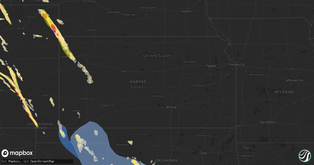
Hail Map in Kansas on July 8, 2023
Get this storm
July 8 map
$229
one time, instant access
Download today. No call, no setup
Keep the $229
Bought the map and want the full workflow? Apply the entire $229 to a subscription within 7 days. None of it is wasted.
Every map, not just this one
This buys you this map. Subscription and you get every map we run, in the markets you choose from a few cities to whole states to nationwide. Plus real-time alerts the moment a storm fires.
Contact data
Name, contact info, occupancy, even credit band for addresses in the footprint. You go from where it hit to who to call.
Become the source they trust
Unlimited branding weather history reports on demand. You already have the documented answer ready for the property owner, and you are the one who showed up with it.
Property data and RoofTrace estimates
Pull up any address you have got, its value and the exact code rules for that jurisdiction, straight from One Click Code. Then RoofTrace estimates the squares, pitch, and roof value, priced the way you price.
Storm reports in Kansas
Kansas
| Date | Description |
|---|---|
| 07/08/20236:34 PM CDT | Rickety fence blown down by strong winds. Time estimated via radar. |
| 07/08/20235:57 PM CDT | Dime to quarter size hail... Strong northwest winds... 1.50 inches of rain and severe damage to mature wheat... Corn... Trees and windows. Public report via twitter. Ti |
| 07/08/20235:46 PM CDT | Report from mping: 1-inch tree limbs broken. |
| 07/08/20235:45 PM CDT | Nickel to quarter sized hail reported to have accumulated at location. Hail with winds damaged garden at location as well. |
| 07/08/20235:45 PM CDT | Report received via social media of an estimated 60 mph wind gust at location. |
| 07/08/20235:45 PM CDT | Pea to quarter sized hail reported via social media at location. |
| 07/08/20235:45 PM CDT | Report received via social media of a garden damaged by strong winds and hail. |
| 07/08/20235:45 PM CDT | Report received via social media of at least 4 large trees downed by strong winds in st. Francis... Ks with one possibly damaging the front of a pick-up truck. Time est |
| 07/08/20235:45 PM CDT | Mesonet station gw1726 st francis airport. |
| 07/08/20235:40 PM CDT | Estimated 60 mph wind gusts reported blowing leaves off trees with torrential rain blowing sideways and causing 50 yd visibility. |
| 07/08/20235:15 PM CDT | Quarter sized hail at location while with strong winds bending the trees. |
| 07/07/202311:06 PM CDT | Mesonet station cw8810 elkhart. |
| 07/07/202311:05 PM CDT | Mesonet station up407 0.6 sw hayne |
| 07/07/20238:25 PM CDT | A local report indicates 61 MPH wind near 1 ESE Scott State Lake |
| 07/07/20237:40 PM CDT | Corrects previous non-tstm wnd gst report from 3 sw russell springs. Mesonet station ussk1 russell springs 3sw. 10m wind gust measurement. |
| 07/07/20237:40 PM CDT | Corrects previous non-tstm wnd gst report from 3 sw russell springs. Mesonet station ussk1 russell springs 3sw. 10m wind gust measurement. |
| 07/07/20237:30 PM CDT | Report received of several large tree branches downed by wind gusts in winona... Ks. Time is radar estimated. |
| 07/07/20237:30 PM CDT | Corrects previous tstm wnd dmg report from winona. Report received of several large tree branches downed by wind gusts in winona... Ks. A large pine tree was also repor |
| 07/07/20237:29 PM CDT | Mesonet station up840 9.0 w winona |
All States Impacted by Hail Map on July 8, 2023
Cities Impacted by Hail Map on July 8, 2023
- Idabel, OK
- Valliant, OK
- Winthrop, AR
- Foreman, AR
- Heavener, OK
- Howe, OK
- Haworth, OK
- Broken Bow, OK
- Gwinn, MI
- Hodgen, OK
- Wister, OK
- Rattan, OK
- Snow, OK
- Nashoba, OK
- Vernon, AL
- Sulligent, AL
- Poteau, OK
- Robinson, IL
- Willow Hill, IL
- Flat Rock, IL
- Oblong, IL
- Hot Springs National Park, AR
- West Liberty, IL
- Sardis, MS
- Red Oak, OK
- Claremont, IL
- Little Rock, AR
- Lake Cormorant, MS
- Charlotte, NC
- Heth, AR
- Earle, AR
- Fulton, MS
- Kinta, OK
- Rapid City, SD
- Scottsbluff, NE
- Harrison, NE
- Rock, MI
- Rapid River, MI
- Minatare, NE
- Bayard, NE
- Melbeta, NE
- Gering, NE
- Mcgrew, NE
- Buffalo, WY
- Kaycee, WY
- Harrisburg, NE
- Platteville, CO
- Fort Lupton, CO
- Bridgeport, NE
- Greenbrier, TN
- Springfield, TN
- Goodlettsville, TN
- Haxtun, CO
- Hudson, CO
- Lusk, WY
- Keenesburg, CO
- Hendersonville, TN
- Whites Creek, TN
- Joelton, TN
- Madison, TN
- Holyoke, CO
- Old Hickory, TN
- Nashville, TN
- Yuma, CO
- Wray, CO
- Jay Em, WY
- Morrison, CO
- Littleton, CO
- Denver, CO
- Torrington, WY
- Haigler, NE
- Lone Tree, CO
- Castle Rock, CO
- Parker, CO
- Englewood, CO
- Saint Francis, KS
- Kimball, NE
- Colorado Springs, CO
- Peyton, CO
- Hermitage, TN
- Mount Juliet, TN
- Dix, NE
- Dalton, NE
- Gurley, NE
- Sidney, NE
- Newcastle, WY
- Lance Creek, WY
- Douglas, WY
- Gillette, WY
- Yoder, CO
- Calhan, CO
- Sedgwick, CO
- Fleming, CO
- Paoli, CO
- Rush, CO
- Goodland, KS
- Edson, KS
- Brewster, KS
- Ramah, CO
- Shannon, NC
- Hartford, KY
- Olaton, KY
- Beaver Dam, KY
- Midwest, WY
- Briggsdale, CO
- Carney, MI
- Deatsville, AL
- Marbury, AL
- Hamlet, NC
- Bennett, CO
- Strasburg, CO
- Mitchell, NE
- Wright City, OK
- Snyder, CO
- Escanaba, MI
- Louisville, MS
- Crenshaw, MS
- Powderly, TX
- Arthur City, TX
- Underwood, IN
- Henryville, IN
- Lexington, IN
- Nabb, IN
- Portland, TN
- Golden, CO
- Evergreen, CO
- Idledale, CO
- Indian Hills, CO
- Milan, TN
- Velva, ND
- Upton, WY
- Greeley, CO
- Eaton, CO
- Lucerne, CO
- Galeton, CO
- Ferdinand, IN
- Red Springs, NC
- Santa Rosa, NM
- Pontotoc, MS
- Randolph, MS
- Blue Mountain, MS
- Ripley, MS
- Prattville, AL
- Verbena, AL
- Paris, TX
- Brookston, TX
- Bark River, MI
- Gibbstown, NJ
- Mickleton, NJ
- Berwyn, PA
- Newtown Square, PA
- Malvern, PA
- Abita Springs, LA
- Bush, LA
- Covington, LA
- Madisonville, LA
- Lodgepole, NE
- Chappell, NE
- Bennington, OK
- Bokchito, OK
- Telephone, TX
- Durant, OK
- Ivanhoe, TX
- Columbus, NJ
- Trenton, NJ
- Robbinsville, NJ
- Chesterfield, NJ
- Marks, MS
- Adolphus, KY
- Bowling Green, KY
- Scottsville, KY
- Alvaton, KY
- Champion, NE
- Carriere, MS
- Picayune, MS
- Garvin, OK
- Ringold, OK
- Evanston, IN
- Grandview, IN
- Lamar, IN
- Faunsdale, AL
- Linden, AL
- Perkins, MI
- Cuervo, NM
- Arlington, AL
- Thomaston, AL
- Catherine, AL
- Crook, CO
- Iliff, CO
- Hopkinsville, KY
- Crofton, KY
- Media, PA
- Glen Mills, PA
- Flourtown, PA
- Fort Washington, PA
- Lafayette Hill, PA
- Saint Meinrad, IN
- Santa Claus, IN
- Coosada, AL
- Wetumpka, AL
- Bethpage, TN
- Westmoreland, TN
- Opp, AL
- Ruidoso, NM
- Byers, CO
- Lonoke, AR
- Defuniak Springs, FL
- Nichols, SC
- Boswell, OK
- Atoka, OK
- Pembroke, KY
- Elkton, KY
- Trenton, KY
- Watford City, ND
- Corona, NM
- Live Oak, FL
- Mayo, FL
- Marianna, AR
- Palestine, AR
- Samson, AL
- Coffee Springs, AL
- Deport, TX
- Pattonville, TX
- Charleston, SC
- Clanton, AL
- Elba, AL
- Jack, AL
- English, IN
- Galivants Ferry, SC
- Kinston, AL
- Elmore, AL
- Moro, AR
- Cottontown, TN
- Trenton, TN
- South Hadley, MA
- Granby, MA
- Blossom, TX
- Saginaw, MI
- Batesville, MS
- Olney Springs, CO
- Boone, CO
- Ordway, CO
- Manville, WY
- Lost Springs, WY
- Cheyenne, WY
- Carpenter, WY
- Grover, CO
- Nunn, CO
- Sugar City, CO
- Manzanola, CO
- Rocky Ford, CO
- Swink, CO
- La Junta, CO
- Shawnee, WY
- Glendo, WY
- Orchard, CO
- Las Animas, CO
- Kim, CO
- Weldona, CO
- Karval, CO
- Pritchett, CO
- Canyon, TX
- Wildorado, TX
- Amarillo, TX
- Happy, TX
- Andalusia, AL
- Wing, AL
- Elgin, AZ
- Tucumcari, NM
- Marlborough, NH
- Nelson, NH
- Harrisville, NH
- Voltaire, ND
- Hereford, AZ
- Bisbee, AZ
- New Madrid, MO
- Martinsdale, MT
- Ronda, NC
- Birch Tree, MO
- Alton, MO
- Trementina, NM
- Aynor, SC
- Elizabeth, CO
- Winona, KS
- Monument, KS
- Otis, CO
- Akron, CO
- Lilbourn, MO
- Maxton, NC
- Brush, CO
- Hugo, CO
- Grafton, NH
- Kiowa, CO
- Elbert, CO
- Pueblo, CO
- Conchas Dam, NM
- Evergreen, AL
- Castleberry, AL
- Dayton, TN
- Fountain, CO
- Hartford, AL
- Chancellor, AL
- Enterprise, AL
- Daleville, AL
- Burns, WY
- Hillsdale, WY
- Eckley, CO
- Couch, MO
- Deer Trail, CO
- Franktown, CO
- Oakley, KS
- Rumney, NH
- Wagon Mound, NM
- Myrtle, MO
- Matheson, CO
- Ridgeway, SC
- Troup, TX
- Bosler, WY
- Colby, KS
- Bristol, NH
- Scott City, KS
- Healy, KS
- Newport, NH
- Wheatland, WY
- Garrett, WY
- Gould City, MI
- San Jon, NM
- Grinnell, KS
- Ackerman, MS
- Geneva, AL
- Roxton, TX
- Granada, CO
- Springfield, NH
- Lamar, CO
- Canaan, NH
- Thayer, MO
- Roswell, NM
- Paoli, PA
- Goodwell, OK
- Keyes, OK
- Texhoma, OK
- Elkhart, KS
- Meade, KS
- Canadian, TX
- Mobeetie, TX
- Gruver, TX
- Forgan, OK
- Hugoton, KS
- Hooker, OK
- Kismet, KS
- Turpin, OK
- Laverne, OK
- Hardesty, OK
- Miami, TX
- Arnett, OK
- Tyrone, OK
- Crawford, OK
- Durham, OK
- Cheyenne, OK
- Reydon, OK
- Higgins, TX
- Guymon, OK
- Pampa, TX
- Plains, KS
- Briscoe, TX
- Beaver, OK
- Darrouzett, TX
- Perryton, TX
- Liberal, KS
- Spearman, TX
- Follett, TX
- Stinnett, TX
- Lipscomb, TX
- Gate, OK
- Shattuck, OK
- Balko, OK
- Booker, TX
- Wheeler, TX
- Leedey, OK
- Hammon, OK
- Butler, OK
- Taloga, OK
- Oakwood, OK
- Fay, OK
- Watonga, OK
- Putnam, OK
- Gage, OK
- Camargo, OK
- Vici, OK
- Canton, OK
- Shamrock, TX
- Sweetwater, OK
- Sayre, OK
- Elk City, OK
- Custer City, OK
- Thomas, OK
- Clinton, OK
- Norman, OK
- Noble, OK
- Texola, OK
- Erick, OK
- Canute, OK
- Carter, OK
- Willow, OK
- Weatherford, OK
- Geary, OK
- Yukon, OK
- Oklahoma City, OK
- Bethany, OK
- Wheatland, OK
- Hydro, OK
- Lookeba, OK
- Hinton, OK
- Cordell, OK
- Rocky, OK
- Gotebo, OK
- Corn, OK
- Sentinel, OK
- Bessie, OK
- Foss, OK
- Granite, OK
- Hobart, OK
- Arapaho, OK
- Lone Wolf, OK
- Roosevelt, OK
- Colony, OK
- Mountain View, OK
- Dill City, OK
- Carnegie, OK
- Gracemont, OK
- Fort Cobb, OK
- Lawton, OK
- Medicine Park, OK
- Greenfield, OK
- Calumet, OK
- Apache, OK
- Binger, OK
- Elgin, OK
- Anadarko, OK
- Tuttle, OK
- Chickasha, OK
- Union City, OK
- Okarche, OK
- Piedmont, OK
- Minco, OK
- El Reno, OK
- Verden, OK
- Cyril, OK
- Mustang, OK
- Amber, OK
- Pocasset, OK
- Mangum, OK
- Blair, OK
- Olustee, OK
- Headrick, OK
- Altus, OK
- Mountain Park, OK
- Altus Afb, OK
- Vinson, OK
- Hollis, OK
- Gould, OK
- Duke, OK
- Eldorado, OK
- Vernon, TX
- Elmer, OK
- Odell, TX
- Snyder, OK
- Frederick, OK
- Tipton, OK
- Chattanooga, OK
- Marlow, OK
- Loveland, OK
- Cache, OK
- Fletcher, OK
- Geronimo, OK
- Fort Sill, OK
- Hollister, OK
- Indiahoma, OK
- Ninnekah, OK
- Rush Springs, OK
- Walters, OK
- Faxon, OK
- Cement, OK
- Newcastle, OK
- Alex, OK
- Blanchard, OK
- Lindsay, OK
- Duncan, OK
- Bradley, OK
- Washington, OK
- Davidson, OK
- Grandfield, OK
- Randlett, OK
- Devol, OK
- Stratford, TX
- Texhoma, TX
- Byers, TX
- Celina, TX
- Temple, OK
- Saint Jo, TX
- Muenster, TX
- Waurika, OK
- Mckinney, TX
- Ryan, OK
- Nocona, TX
- Pilot Point, TX
- Gainesville, TX
- Hastings, OK
- Lindsay, TX
- Valley View, TX
- Maysville, OK
- Purcell, OK
- Wayne, OK
- Lexington, OK
- Macomb, OK
- Tecumseh, OK
- Wanette, OK
- Newalla, OK
- Iowa Park, TX
- Harrold, TX
- Holliday, TX
- Wichita Falls, TX
- Oklaunion, TX
- Burkburnett, TX
- Electra, TX
- Sheppard Afb, TX
- Scotland, TX
- Petrolia, TX
- Archer City, TX
- Henrietta, TX
- Windthorst, TX
- Comanche, OK
- Loco, OK
- Ringling, OK
- Pauls Valley, OK
- Elmore City, OK
- Hennepin, OK
- Healdton, OK
- Foster, OK
- Ratliff City, OK
- Graham, OK
- Tussy, OK
- Byars, OK
- Asher, OK
- Paoli, OK
- Bryson, TX
- Perrin, TX
- Olney, TX
- Bellevue, TX
- Ringgold, TX
- Bowie, TX
- Terral, OK
- Jacksboro, TX
- Springer, OK
- Stratford, OK
- Wynnewood, OK
- Davis, OK
- Wilson, OK
- Boise City, OK
- Mooreland, OK
- Amherst, MA
- Walsh, CO
- Ault, CO
- Ulysses, KS
- Quitaque, TX
- Allen, OK
- Harrah, OK
- Mcloud, OK
- Calvin, OK
- Moscow, KS
- Fort Towson, OK
- Ada, OK
- Tupelo, OK
- Stonewall, OK
- Kingfisher, OK
- Holly, CO
- Atwood, OK
- Omega, OK
- Manter, KS
- Konawa, OK
- Kiowa, OK
- Choctaw, OK
- Sasakwa, OK
- Stuart, OK
- Mcalester, OK
- Seiling, OK
- Meeker, OK
- Wardville, OK
- Holdenville, OK


