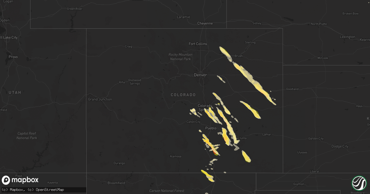
Hail Map in Colorado on July 7, 2024
Get this storm
July 7 map
$229
one time, instant access
Download today. No call, no setup
Keep the $229
Bought the map and want the full workflow? Apply the entire $229 to a subscription within 7 days. None of it is wasted.
Every map, not just this one
This buys you this map. Subscription and you get every map we run, in the markets you choose from a few cities to whole states to nationwide. Plus real-time alerts the moment a storm fires.
Contact data
Name, contact info, occupancy, even credit band for addresses in the footprint. You go from where it hit to who to call.
Become the source they trust
Unlimited branding weather history reports on demand. You already have the documented answer ready for the property owner, and you are the one who showed up with it.
Property data and RoofTrace estimates
Pull up any address you have got, its value and the exact code rules for that jurisdiction, straight from One Click Code. Then RoofTrace estimates the squares, pitch, and roof value, priced the way you price.
Storm reports in Colorado
Colorado
| Date | Description |
|---|---|
| 07/07/20246:50 PM CDT | Video and picture of funnel; chaser did confirm that it did briefly touch ground and was short lived and did not do any damage from what he can tell. |
| 07/07/20246:48 PM CDT | A local report indicates 1.75 inch wind near 4 SE Colorado City |
| 07/07/20246:44 PM CDT | Report from mping: quarter |
| 07/07/20246:42 PM CDT | A local report indicates 1.00 inch wind near 4 SE Colorado City |
| 07/07/20246:39 PM CDT | Report from mping: quarter |
| 07/07/20246:30 PM CDT | Estimated quarter sized hail. Time radar estimated. |
| 07/07/20246:30 PM CDT | Accumulating hail estimated to be golf ball in size. Hail was covering the ground. Timing estimated via radar. |
| 07/07/20246:20 PM CDT | Hail size and time is estimated based on a picture from social media. |
| 07/07/20246:20 PM CDT | Delayed report via social media. Accumulating pea to quarter sized hail in a corn field. Unknown depth of hail accumulation. |
| 07/07/20246:15 PM CDT | Estimated quarter sized hail. |
| 07/07/20246:14 PM CDT | Exact location on i-70 |
| 07/07/20246:13 PM CDT | Pea to golf ball hail was ongoing... But slowing down over the location after a duration of 5 minutes as of 5:17 pm. |
| 07/07/20246:05 PM CDT | Estimating ping pong ball size hail and around 50 mph winds at location of cr y and 13. |
| 07/07/20245:15 PM CDT | A local report indicates 1.75 inch wind near 16 W Forder |
| 07/07/20245:09 PM CDT | Report from mping: quarter |
| 07/07/20244:29 PM CDT | A local report indicates 1.75 inch wind near 1 NNW Woodrow |
| 07/07/20244:03 PM CDT | A local report indicates 1.50 inch wind near 1 SSE Security |
| 07/07/20243:42 PM CDT | Report from mping: quarter |
| 07/06/20247:03 PM CDT | A local report indicates 1.00 inch wind near 7 SE Peyton |
| 07/06/20247:00 PM CDT | A local report indicates 1.00 inch wind near 4 SE Peterson AFB |
All States Impacted by Hail Map on July 7, 2024
Cities Impacted by Hail Map on July 7, 2024
- Noble, OK
- Lexington, OK
- Norman, OK
- Wanette, OK
- Macomb, OK
- Tecumseh, OK
- Asher, OK
- Konawa, OK
- Ada, OK
- Stratford, OK
- Sasakwa, OK
- Roff, OK
- Mill Creek, OK
- Sulphur, OK
- Tishomingo, OK
- Stonewall, OK
- Coalgate, OK
- Lawson, MO
- Rayville, MO
- Richmond, MO
- Polo, MO
- Atoka, OK
- Kahoka, MO
- Wheeling, MO
- Meadville, MO
- Luray, MO
- Caddo, OK
- Caney, OK
- Wayland, MO
- Farmington, IA
- Higginsville, MO
- Keota, OK
- Argyle, IA
- Chambers, NE
- Corder, MO
- Rutledge, MO
- Knox City, MO
- Edina, MO
- Montrose, IA
- Revere, MO
- Linneus, MO
- Trenton, MO
- Galt, MO
- Browning, MO
- Humphreys, MO
- Lexington, MO
- La Belle, MO
- Wyaconda, MO
- Bassett, NE
- Spiro, OK
- Ewing, NE
- Hardin, MO
- Norborne, MO
- Mayview, MO
- Odessa, MO
- Williamstown, MO
- Burwell, NE
- Cameron, OK
- Bokoshe, OK
- Shady Point, OK
- Minocqua, WI
- Mendon, MO
- Rothville, MO
- Poteau, OK
- Saint Patrick, MO
- Monticello, MO
- Marceline, MO
- Novelty, MO
- Canton, MO
- Bartlett, NE
- Wolford, ND
- Rugby, ND
- Oneill, NE
- Defuniak Springs, FL
- Briggsdale, CO
- Alexandria, MO
- Kersey, CO
- Orchard, CO
- Warsaw, IL
- Elgin, NE
- Clearwater, NE
- Malta Bend, MO
- Weldona, CO
- Wiggins, CO
- Raton, NM
- Pierce, NE
- Britton, SD
- Colorado Springs, CO
- Neligh, NE
- Lewistown, MO
- Campbell, MN
- Fort Morgan, CO
- Gilmer, TX
- Big Sandy, TX
- Richardton, ND
- Langford, SD
- Breckenridge, MN
- Sutter, IL
- Fountain, CO
- Pittsburg, TX
- Madison, MO
- Holliday, MO
- Troy, AL
- Paris, MO
- Shelbina, MO
- Ewing, MO
- Pueblo, CO
- Ord, NE
- Elyria, NE
- Ericson, NE
- Durham, MO
- Osmond, NE
- Jakin, GA
- Leesburg, TX
- Winnsboro, TX
- Seale, AL
- Binger, OK
- Gracemont, OK
- Westminster, SC
- Quincy, IL
- Hoskins, NE
- Randolph, NE
- Woodrow, CO
- Lake Park, GA
- Statenville, GA
- Carroll, NE
- Yoder, CO
- Rush, CO
- Akron, CO
- Lindon, CO
- Minco, OK
- Norfolk, NE
- Albion, NE
- Mendon, IL
- Fowler, IL
- Winside, NE
- Hinton, OK
- Anadarko, OK
- El Reno, OK
- Union City, OK
- Fort Cobb, OK
- Coatsburg, IL
- Camp Point, IL
- Paloma, IL
- Anton, CO
- Marshallville, GA
- Granite, OK
- Hatchechubbee, AL
- Fort Mitchell, AL
- Boone, CO
- Napoleon, ND
- Sudan, TX
- Fargo, GA
- Amherst, TX
- Cope, CO
- Wayne, NE
- Cedar Rapids, NE
- New Berlin, WI
- Pocasset, OK
- Barry, TX
- Greeley, NE
- Wolbach, NE
- Lockney, TX
- Garner, IA
- Spalding, NE
- Leola, SD
- Murrayville, GA
- Cleveland, GA
- Primrose, NE
- Saint Edward, NE
- Belgrade, NE
- Littlefield, TX
- Flagler, CO
- Pep, TX
- Arriba, CO
- Sergeant Bluff, IA
- Sioux City, IA
- Dakota City, NE
- Brookfield, WI
- Waukesha, WI
- Earth, TX
- Verden, OK
- Amber, OK
- Chickasha, OK
- Ninnekah, OK
- Blanchard, OK
- Cement, OK
- Apache, OK
- Cyril, OK
- Bronson, IA
- Lawton, IA
- Moville, IA
- Lone Wolf, OK
- Gainesville, GA
- Hale Center, TX
- Springlake, TX
- Forest City, IA
- Dahlonega, GA
- Sentinel, OK
- Tuttle, OK
- Elm Grove, WI
- Palmer, NE
- Fullerton, NE
- Chatham, LA
- Jonesboro, LA
- Seibert, CO
- Ventura, IA
- Weston, CO
- Clovis, NM
- Matador, TX
- Cannon Afb, NM
- Cripple Creek, CO
- Florissant, CO
- Levelland, TX
- Crescent, IA
- Council Bluffs, IA
- Honey Creek, IA
- Strasburg, CO
- Byers, CO
- Muleshoe, TX
- Olton, TX
- Floydada, TX
- Ionia, IA
- Nashua, IA
- Alex, OK
- Herreid, SD
- Hague, ND
- Portales, NM
- Lindsay, OK
- Elbert, CO
- Kiowa, CO
- Vona, CO
- Plainview, TX
- Deer Trail, CO
- Anthon, IA
- Hornick, IA
- Climbing Hill, IA
- Lubbock, TX
- Wolfforth, TX
- Pollock, SD
- Calhan, CO
- Abernathy, TX
- Peyton, CO
- Bradley, OK
- Ipswich, SD
- New Hampton, IA
- Mountain View, OK
- Fletcher, OK
- Rush Springs, OK
- Ropesville, TX
- Platte Center, NE
- Purcell, OK
- Neola, IA
- Underwood, IA
- Stratton, CO
- Shallowater, TX
- Colorado City, CO
- Rye, CO
- Winnebago, NE
- Homer, NE
- Columbus, NE
- Petersburg, TX
- Hobart, OK
- Roosevelt, OK
- Guffey, CO
- Mangum, OK
- Walsenburg, CO
- Trinidad, CO
- Blair, OK
- Idalou, TX
- Bethune, CO
- Rogers, NM
- Childress, TX
- Maysville, OK
- McClelland, IA
- Foster, OK
- Elmore City, OK
- Roaring Springs, TX
- Minden, IA
- Lorenzo, TX
- Hephzibah, GA
- Mcadoo, TX
- Wetumpka, AL
- Union, SC
- Oakwood, GA
- Rushford, MN
- Holstein, IA
- Schuyler, NE
- Causey, NM
- Pauls Valley, OK
- Cheyenne Wells, CO
- Enochs, TX
- Ralls, TX
- Karval, CO
- Hugo, CO
- Wilson, TX
- Calhoun, LA
- Crosbyton, TX
- Dickens, TX
- Augusta, GA
- Burlington, CO
- Missouri Valley, IA
- Mountain Park, OK
- Snyder, OK
- Montgomery, AL
- Tahoka, TX
- New Deal, TX
- Slaton, TX
- Ransom Canyon, TX
- Anton, TX
- Smyer, TX
- Monroe, NE
- Frederick, OK
- Tuttle, ND
- Dupree, SD
- Downsville, LA
- Strasburg, ND
- Braselton, GA
- Scottdale, GA
- Decatur, GA
- Avondale Estates, GA
- Post, TX
- Afton, TX
- Persia, IA
- Logan, IA
- Canon City, CO
- Rogers, NE
- Linwood, NE
- Model, CO
- Paducah, TX
- Thomasville, AL
- Robinson, ND
- Comanche, OK
- Stone Mountain, GA
- Ratliff City, OK
- Tussy, OK
- Hennepin, OK
- Kit Carson, CO
- Haswell, CO
- Loveland, OK
- Chaseley, ND
- David City, NE
- Clarkston, GA
- Olney Springs, CO
- Rocky Ford, CO
- Spur, TX
- Justiceburg, TX
- Lithonia, GA
- Harvard, NE
- Indiahoma, OK
- Eads, CO
- Chattanooga, OK
- Buford, GA
- Trumbull, NE
- Giltner, NE
- Boncarbo, CO
- Fowler, CO
- Duncan, OK
- Hollister, OK
- Davidson, OK
- Davis, OK
- Springer, OK
- Ordway, CO
- Walters, OK
- Waurika, OK
- Manzanola, CO
- Crowley, CO
- Suwanee, GA
- Beulah, CO
- Temple, OK
- Sugar City, CO
- Wagon Mound, NM
- Miami, NM
- Springer, NM
- Crowell, TX
- Devol, OK
- Grandfield, OK
- Canton, GA
- Jayton, TX
- Snyder, TX
- Girard, TX
- Aspermont, TX
- Fontanelle, IA
- Burkburnett, TX
- Bridgewater, IA
- Greenfield, IA
- Farragut, IA
- Ringling, OK
- Stuart, IA
- Randlett, OK
- Sheppard Afb, TX
- Wichita Falls, TX
- Ryan, OK
- Avondale, CO
- Dexter, IA
- Winterset, IA
- Vernon, TX
- Henrietta, TX
- Seymour, TX
- Monroe, IA
- Earlham, IA
- Byers, TX
- Prairie City, IA
- Sully, IA
- Reasnor, IA
- Newton, IA
- Kim, CO
- Kellogg, IA
- Lynnville, IA
- La Junta, CO
- Throckmorton, TX
- Trinchera, CO
- Pella, IA
- Leighton, IA
- New Sharon, IA
- Oskaloosa, IA
- Woodson, TX
- Graham, TX
- Newcastle, TX
- Ellenwood, GA
- Elmaton, TX
- Palacios, TX
- Matagorda, TX
- Bay City, TX
- Port Lavaca, TX
- Brazoria, TX
- Freeport, TX
- Elk City, OK
- Gladstone, NM
- Blessing, TX
- Markham, TX
- Van Vleck, TX
- Sweeny, TX
- Lolita, TX
- Midfield, TX
- Grove, OK
- El Campo, TX
- Louise, TX
- Lake Jackson, TX
- Clute, TX
- Ganado, TX
- Wharton, TX
- Port O'Connor, TX
- Seadrift, TX
- Vanderbilt, TX
- Edna, TX
- Rockport, TX
- Tivoli, TX
- Bloomington, TX
- La Salle, TX
- Angleton, TX
- West Columbia, TX
- Pledger, TX
- Boling, TX
- Damon, TX
- Las Vegas, NM
- Trementina, NM
- Sapello, NM
- Danbury, TX
- Galveston, TX
- Melrose, NM
- Cuervo, NM
- Mosquero, NM
- Conchas Dam, NM
- Garita, NM
- Newkirk, NM
- House, NM
- Floyd, NM
- Santa Rosa, NM
- Liverpool, TX
- Hitchcock, TX
- Port Bolivar, TX
- La Marque, TX
- Seabrook, TX
- Santa Fe, TX
- Manvel, TX
- Rosharon, TX
- Alvin, TX
- Pearland, TX
- South Houston, TX
- Missouri City, TX
- Dickinson, TX
- Webster, TX
- Kemah, TX
- Houston, TX
- League City, TX
- Pasadena, TX
- Texas City, TX
- Bacliff, TX
- Friendswood, TX
- Baytown, TX
- La Porte, TX
- Richmond, TX
- Beasley, TX
- Sugar Land, TX
- Guy, TX
- Fresno, TX
- Stafford, TX
- East Bernard, TX
- Rosenberg, TX
- Needville, TX
- Glen Flora, TX
- Fitzhugh, OK
- Eagle Lake, TX
- Wallis, TX
- Deer Park, TX
- Bellaire, TX
- Katy, TX
- Fulshear, TX
- Fort Sumner, NM
- Kingwood, TX
- Humble, TX
- Galena Park, TX
- Channelview, TX
- Cypress, TX
- Brookshire, TX
- Dayton, TX
- Highlands, TX
- Crosby, TX
- Anahuac, TX
- Chillicothe, TX
- Lookeba, OK
- Spring, TX
- Porter, TX
- Tomball, TX
- Hollis, OK
- Sealy, TX
- Hockley, TX
- Taiban, NM
- Waller, TX
- Magnolia, TX
- Pinehurst, TX
- Huffman, TX
- Conroe, TX
- New Caney, TX
- Plantersville, TX
- Montgomery, TX
- Willis, TX
- Splendora, TX
- Cleveland, TX
- Hempstead, TX
- Bellville, TX
- Prairie View, TX
- Navasota, TX
- Washington, TX
- Richards, TX
- Anderson, TX
- Coldspring, TX
- Shepherd, TX
- Livingston, TX
- New Waverly, TX
- Huntsville, TX
- Oakhurst, TX
- Pointblank, TX
- Iola, TX
- Bedias, TX
- Bryan, TX
- Victor, CO
- Brush, CO
- Midway, TX
- Madisonville, TX
- Lovelady, TX
- Trinity, TX
- North Zulch, TX
- Groveton, TX
- Onalaska, TX
- Goodrich, TX
- Lufkin, TX
- Diboll, TX
- Corrigan, TX
- Moscow, TX
- Pennington, TX
- Crockett, TX
- Kennard, TX
- Apple Springs, TX
- Beaumont, TX


