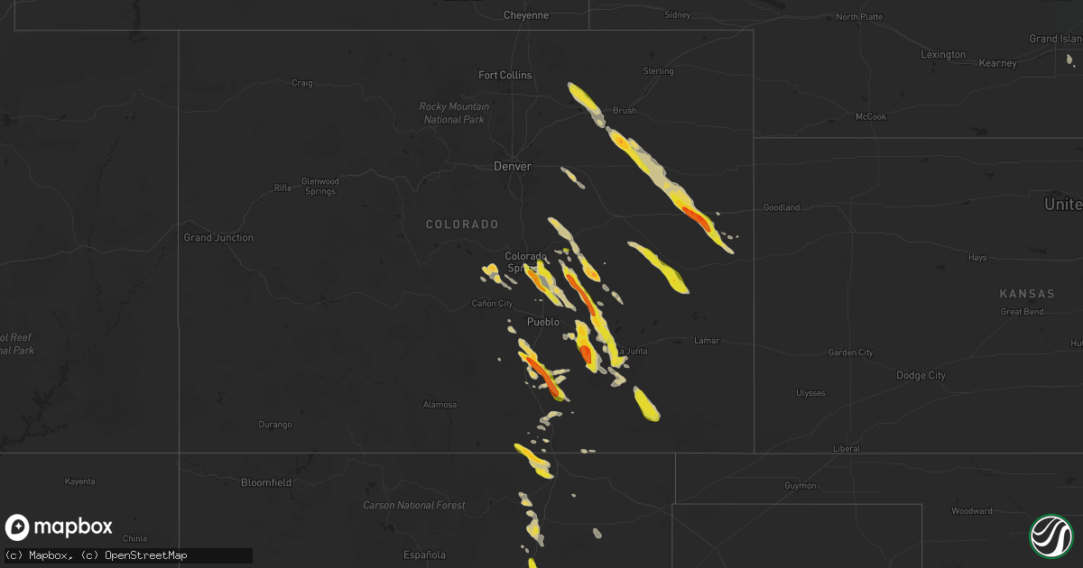
Hail Map on July 7, 2024
Get this storm
July 7 map
$229
one time, instant access
Download today. No call, no setup
Keep the $229
Bought the map and want the full workflow? Apply the entire $229 to a subscription within 7 days. None of it is wasted.
Every map, not just this one
This buys you this map. Subscription and you get every map we run, in the markets you choose from a few cities to whole states to nationwide. Plus real-time alerts the moment a storm fires.
Contact data
Name, contact info, occupancy, even credit band for addresses in the footprint. You go from where it hit to who to call.
Become the source they trust
Unlimited branding weather history reports on demand. You already have the documented answer ready for the property owner, and you are the one who showed up with it.
Property data and RoofTrace estimates
Pull up any address you have got, its value and the exact code rules for that jurisdiction, straight from One Click Code. Then RoofTrace estimates the squares, pitch, and roof value, priced the way you price.
States Impacted by Hail Map on July 7, 2024
Storm reports
Texas
| Date | Description |
|---|---|
| 07/07/20246:58 PM CDT | A local report indicates 71 MPH wind near 3 NNW Mcadoo |
| 07/07/20246:53 PM CDT | A local report indicates 60 MPH wind near 6 S Wolfforth |
| 07/07/20246:53 PM CDT | A local report indicates 66 MPH wind near 1 NNW Lubbock Int. Airp |
| 07/07/20246:50 PM CDT | Wind gusts estimated in the 70 to 80 mph range from 6:45 to 6:50 pm. |
| 07/07/20246:50 PM CDT | Tree trunk snapped at phil hoel park. Time estimated by radar. |
| 07/07/20246:46 PM CDT | A local report indicates 58 MPH wind near 3 WNW Lubbock |
| 07/07/20246:43 PM CDT | A local report indicates 66 MPH wind near 6 ENE Abernathy |
| 07/07/20246:40 PM CDT | A local report indicates 65 MPH wind near Reese Center |
| 07/07/20246:35 PM CDT | Report from mping: quarter |
| 07/07/20245:47 PM CDT | 1.25-1.50 inches. |
| 07/07/20242:54 PM CDT | Trees down in the 900 block of old highway 59. |
| 07/07/20242:53 PM CDT | Trees down in the 4600 block of highway 69 north just northwest of lufkin. |
| 07/07/20242:48 PM CDT | Trees down on bethlehem road in hudson. |
| 07/07/20242:30 PM CDT | Two trees were downed onto power lines near the intersection of fm 58 and southern drive. |
| 07/07/20241:55 PM CDT | Severe thunderstorm wind gusts damaged trees across northern tyler county. 888 customers were out of power due to large trees falling on transformers and power lines. |
| 07/07/20242:40 AM CDT | Pcnt2 - port oconnor. |
| 07/06/202410:55 PM CDT | A local report indicates 60 MPH wind near 3 NNW Seymour |
| 07/06/20249:32 PM CDT | A local report indicates 72 MPH wind near Sheppard Afb |
| 07/06/20249:19 PM CDT | 5-6 inch tree limbs down. |
| 07/06/20249:11 PM CDT | A local report indicates 64 MPH wind near 3 E Snyder |
| 07/06/20248:50 PM CDT | A local report indicates 61 MPH wind near 1 SSE Jayton |
| 07/06/20248:42 PM CDT | Report from mping: quarter |
| 07/06/20248:17 PM CDT | A local report indicates 59 MPH wind near 1 NW Lake Alan Henry |
| 07/06/20248:02 PM CDT | Corrects previous non-tstm wnd gst report from white river lake. |
| 07/06/20248:00 PM CDT | Corrects previous non-tstm wnd gst report from 5 ssw graham. |
| 07/06/20247:56 PM CDT | Corrects previous non-tstm wnd gst report from 1 ne post. |
| 07/06/20247:31 PM CDT | A local report indicates 75 MPH wind near 1 SE Ralls |
| 07/06/20247:30 PM CDT | Public submitted a video to broadcast media of a possible tornado near 11th street and north street as well as martin luther king and i-10. |
| 07/06/20247:29 PM CDT | A local report indicates 67 MPH wind near 1 SE Ralls |
| 07/06/20247:25 PM CDT | Shipping container overturned. |
| 07/06/20247:19 PM CDT | A local report indicates 66 MPH wind near 2 NE Slaton |
| 07/06/20247:01 PM CDT | Report from mping: 1-inch tree limbs broken; shingles blown off. |
| 07/06/20247:01 PM CDT | A local report indicates 74 MPH wind near 4 E Lubbock |
Wisconsin
| Date | Description |
|---|---|
| 07/07/20245:45 PM CDT | Emergency management reports tree damage on the corner of elmhurst pkwy & legion dr in elm grove. |
| 07/07/20245:41 PM CDT | Photo of tree limb damage on the corner of 118th and cherry streets in wauwatosa. Time estimated from radar. |
Illinois
| Date | Description |
|---|---|
| 07/07/20245:56 PM CDT | 3-inch tree limbs broken... And power poles blown down along highway 67. Photo on twitter. |
| 07/07/20244:45 PM CDT | Vegetation has been knocked over and tree branches are posing a hazard to traffic. Exact size of tree branches are unknown. |
Iowa
| Date | Description |
|---|---|
| 07/07/20246:57 PM CDT | A local report indicates 1.50 inch wind near 4 NE Council Bluffs |
| 07/07/20246:50 PM CDT | A local report indicates 1.25 inch wind near 4 NE Council Bluffs |
| 07/07/20246:20 PM CDT | A local report indicates 1.75 inch wind near Crescent |
| 07/07/20245:50 PM CDT | A local report indicates 1.25 inch wind near 1 ENE Sergeant Bluff |
| 07/07/20241:55 PM CDT | Four inch diameter tree branches down. Several branches blown down. |
| 07/07/20241:55 PM CDT | A local report indicates 1.00 inch wind near Argyle |
| 07/06/20249:34 PM CDT | Personal weather station kiagreen16. |
Colorado
| Date | Description |
|---|---|
| 07/07/20246:50 PM CDT | Video and picture of funnel; chaser did confirm that it did briefly touch ground and was short lived and did not do any damage from what he can tell. |
| 07/07/20246:48 PM CDT | A local report indicates 1.75 inch wind near 4 SE Colorado City |
| 07/07/20246:44 PM CDT | Report from mping: quarter |
| 07/07/20246:42 PM CDT | A local report indicates 1.00 inch wind near 4 SE Colorado City |
| 07/07/20246:39 PM CDT | Report from mping: quarter |
| 07/07/20246:30 PM CDT | Estimated quarter sized hail. Time radar estimated. |
| 07/07/20246:30 PM CDT | Accumulating hail estimated to be golf ball in size. Hail was covering the ground. Timing estimated via radar. |
| 07/07/20246:20 PM CDT | Delayed report via social media. Accumulating pea to quarter sized hail in a corn field. Unknown depth of hail accumulation. |
| 07/07/20246:20 PM CDT | Hail size and time is estimated based on a picture from social media. |
| 07/07/20246:15 PM CDT | Estimated quarter sized hail. |
| 07/07/20246:14 PM CDT | Exact location on i-70 |
| 07/07/20246:13 PM CDT | Pea to golf ball hail was ongoing... But slowing down over the location after a duration of 5 minutes as of 5:17 pm. |
| 07/07/20246:05 PM CDT | Estimating ping pong ball size hail and around 50 mph winds at location of cr y and 13. |
| 07/07/20245:15 PM CDT | A local report indicates 1.75 inch wind near 16 W Forder |
| 07/07/20245:09 PM CDT | Report from mping: quarter |
| 07/07/20244:29 PM CDT | A local report indicates 1.75 inch wind near 1 NNW Woodrow |
| 07/07/20244:03 PM CDT | A local report indicates 1.50 inch wind near 1 SSE Security |
| 07/07/20243:42 PM CDT | Report from mping: quarter |
| 07/06/20247:03 PM CDT | A local report indicates 1.00 inch wind near 7 SE Peyton |
| 07/06/20247:00 PM CDT | A local report indicates 1.00 inch wind near 4 SE Peterson AFB |
South Carolina
| Date | Description |
|---|---|
| 07/07/20244:40 PM CDT | One tree down on coffee road. |
| 07/06/20248:16 PM CDT | Large tree down blocking the roadway at the intersection of st. Lukes road at morris road. |
South Dakota
| Date | Description |
|---|---|
| 07/07/20241:56 PM CDT | A local report indicates 61 MPH wind near 27 WNW Castle Rock |
Missouri
| Date | Description |
|---|---|
| 07/07/20244:58 AM CDT | Delayed report. Time estimate. Photo of tree down on social media. |
| 07/07/20244:48 AM CDT | Delayed report. Time estimate. Photos of a down tree from social media. |
Georgia
| Date | Description |
|---|---|
| 07/07/20246:30 PM CDT | Tree down at walnut grove way and blue sky ct. |
| 07/07/20246:25 PM CDT | Tree down at 1100 block of ednaville rd. |
| 07/06/20248:32 PM CDT | Tree down on timor trail at the intersection of timor terrace. |
| 07/06/20248:20 PM CDT | Powerlines down across road at intersection of w side pl and moore rd. |
| 07/06/20248:15 PM CDT | Tree down across road at intersection of dogwood farm rd and lehigh blvd. |
| 07/06/20248:10 PM CDT | Tree down across road at intersection of magnolia path and oakleaf cove. |
| 07/06/20248:05 PM CDT | Tree down across road on 3500 block of maryvale dr. |
| 07/06/20248:00 PM CDT | Corrects previous tstm wnd dmg report from 2 ene panthersville. Powerlines down across road on springside ln. |
| 07/06/20248:00 PM CDT | Tree down across road at intersection of redan rd and holcombe rd. |
| 07/06/20247:59 PM CDT | Tree down on navarre court at intersection of navarre drive. |
| 07/06/20247:55 PM CDT | Tree down across road at intersection of glenwood rd and meadow ln. |
| 07/06/20247:50 PM CDT | Tree down across road at intersection of seven hills ct and indian manor dr. |
| 07/06/20247:45 PM CDT | Powerlines down across road at intersection of hillyer ave and brown pl. |
| 07/06/20247:29 PM CDT | Treedown on briarcliff road between shallowford road ne and henderson mill road ne. |
| 07/06/20247:29 PM CDT | Tree down at intersection of woodridge drive and larry lane. |
| 07/06/20247:29 PM CDT | Tree down on at intersection of pangborn road and springbrook drive. |
| 07/06/20247:05 PM CDT | Tree down on regalwoods drive between northcrest road and summitridge drive. |
| 07/06/20247:03 PM CDT | Richmond county dispatch reported damage at the intersection of peach orchard road and tobacco road. Mentioned additional downed trees and power lines reports scattered |
Oklahoma
| Date | Description |
|---|---|
| 07/07/20246:59 PM CDT | Power lines down on roadway starting small fires. Time estimated. |
| 07/07/20246:53 PM CDT | Spotter report of quarter sized hail. |
| 07/07/20246:53 PM CDT | Spotter report of quarter sized hail. (oun |
| 07/07/20246:45 PM CDT | Time estimated. |
| 07/07/20246:05 PM CDT | Tree downed blocking county street 2940. Time estimated. |
| 07/07/20245:40 PM CDT | A local report indicates 59 MPH wind near 4 ENE Apache |
| 07/07/20245:35 PM CDT | A local report indicates 62 MPH wind near 3 NW Chickasha |
| 07/07/20241:26 PM CDT | Tree down blocking roadway northeast of claremore... Near 450 road between 4160 road and 4170 road. Relayed by off duty nws employee. |
| 07/06/20248:50 PM CDT | A local report indicates 58 MPH wind near 3 W Grandfield |
| 07/06/20248:37 PM CDT | A local report indicates 1.00 inch wind near 4 SSW Chattanooga |
| 07/06/20248:15 PM CDT | 75 mph wind gusts measured by storm spotter in hollister. |
| 07/06/20248:14 PM CDT | Emergency manager measured wind gusts at 60 mph. |
| 07/06/20247:53 PM CDT | Quarter sized hail reported near lake frederick. |
| 07/06/20247:45 PM CDT | Camper overturned and large limbs downed. Time estimated from radar. |
| 07/06/20247:45 PM CDT | Light pole downed. Winds estimated 60-70 mph. Time estimated from radar. |
| 07/06/20247:44 PM CDT | Half dollar sized hail... 4 miles north of elmore city. |
| 07/06/20247:43 PM CDT | Emergency manager reports hail and wind gusts of 70 mph. |
| 07/06/20247:35 PM CDT | Power lines and trees downed... Camper trailer overturned... And a building damaged at lake frederick. |
Nebraska
| Date | Description |
|---|---|
| 07/07/20243:50 PM CDT | A local report indicates 1.00 inch wind near 1 SSE Neligh |
| 07/07/20243:42 PM CDT | A local report indicates 1.00 inch wind near 8 W Elgin |
New Mexico
| Date | Description |
|---|---|
| 07/07/20246:00 PM CDT | Pea to quarter size hail. |
Cities Impacted by Hail Map on July 7, 2024
- Noble, OK
- Lexington, OK
- Norman, OK
- Wanette, OK
- Macomb, OK
- Tecumseh, OK
- Asher, OK
- Konawa, OK
- Ada, OK
- Stratford, OK
- Sasakwa, OK
- Roff, OK
- Mill Creek, OK
- Sulphur, OK
- Tishomingo, OK
- Stonewall, OK
- Coalgate, OK
- Lawson, MO
- Rayville, MO
- Richmond, MO
- Polo, MO
- Atoka, OK
- Kahoka, MO
- Wheeling, MO
- Meadville, MO
- Luray, MO
- Caddo, OK
- Caney, OK
- Wayland, MO
- Farmington, IA
- Higginsville, MO
- Keota, OK
- Argyle, IA
- Chambers, NE
- Corder, MO
- Rutledge, MO
- Knox City, MO
- Edina, MO
- Montrose, IA
- Revere, MO
- Linneus, MO
- Trenton, MO
- Galt, MO
- Browning, MO
- Humphreys, MO
- Lexington, MO
- La Belle, MO
- Wyaconda, MO
- Bassett, NE
- Spiro, OK
- Ewing, NE
- Hardin, MO
- Norborne, MO
- Mayview, MO
- Odessa, MO
- Williamstown, MO
- Burwell, NE
- Cameron, OK
- Bokoshe, OK
- Shady Point, OK
- Minocqua, WI
- Mendon, MO
- Rothville, MO
- Poteau, OK
- Saint Patrick, MO
- Monticello, MO
- Marceline, MO
- Novelty, MO
- Canton, MO
- Bartlett, NE
- Wolford, ND
- Rugby, ND
- Oneill, NE
- Defuniak Springs, FL
- Briggsdale, CO
- Alexandria, MO
- Kersey, CO
- Orchard, CO
- Warsaw, IL
- Elgin, NE
- Clearwater, NE
- Malta Bend, MO
- Weldona, CO
- Wiggins, CO
- Raton, NM
- Pierce, NE
- Britton, SD
- Colorado Springs, CO
- Neligh, NE
- Lewistown, MO
- Campbell, MN
- Fort Morgan, CO
- Gilmer, TX
- Big Sandy, TX
- Richardton, ND
- Langford, SD
- Breckenridge, MN
- Sutter, IL
- Fountain, CO
- Pittsburg, TX
- Madison, MO
- Holliday, MO
- Troy, AL
- Paris, MO
- Shelbina, MO
- Ewing, MO
- Pueblo, CO
- Ord, NE
- Elyria, NE
- Ericson, NE
- Durham, MO
- Osmond, NE
- Jakin, GA
- Leesburg, TX
- Winnsboro, TX
- Seale, AL
- Binger, OK
- Gracemont, OK
- Westminster, SC
- Quincy, IL
- Hoskins, NE
- Randolph, NE
- Woodrow, CO
- Lake Park, GA
- Statenville, GA
- Carroll, NE
- Yoder, CO
- Rush, CO
- Akron, CO
- Lindon, CO
- Minco, OK
- Norfolk, NE
- Albion, NE
- Mendon, IL
- Fowler, IL
- Winside, NE
- Hinton, OK
- Anadarko, OK
- El Reno, OK
- Union City, OK
- Fort Cobb, OK
- Coatsburg, IL
- Camp Point, IL
- Paloma, IL
- Anton, CO
- Marshallville, GA
- Granite, OK
- Hatchechubbee, AL
- Fort Mitchell, AL
- Boone, CO
- Napoleon, ND
- Sudan, TX
- Fargo, GA
- Amherst, TX
- Cope, CO
- Wayne, NE
- Cedar Rapids, NE
- New Berlin, WI
- Pocasset, OK
- Barry, TX
- Greeley, NE
- Wolbach, NE
- Lockney, TX
- Garner, IA
- Spalding, NE
- Leola, SD
- Murrayville, GA
- Cleveland, GA
- Primrose, NE
- Saint Edward, NE
- Belgrade, NE
- Littlefield, TX
- Flagler, CO
- Pep, TX
- Arriba, CO
- Sergeant Bluff, IA
- Sioux City, IA
- Dakota City, NE
- Brookfield, WI
- Waukesha, WI
- Earth, TX
- Verden, OK
- Amber, OK
- Chickasha, OK
- Ninnekah, OK
- Blanchard, OK
- Cement, OK
- Apache, OK
- Cyril, OK
- Bronson, IA
- Lawton, IA
- Moville, IA
- Lone Wolf, OK
- Gainesville, GA
- Hale Center, TX
- Springlake, TX
- Forest City, IA
- Dahlonega, GA
- Sentinel, OK
- Tuttle, OK
- Elm Grove, WI
- Palmer, NE
- Fullerton, NE
- Chatham, LA
- Jonesboro, LA
- Seibert, CO
- Ventura, IA
- Weston, CO
- Clovis, NM
- Matador, TX
- Cannon Afb, NM
- Cripple Creek, CO
- Florissant, CO
- Levelland, TX
- Crescent, IA
- Council Bluffs, IA
- Honey Creek, IA
- Strasburg, CO
- Byers, CO
- Muleshoe, TX
- Olton, TX
- Floydada, TX
- Ionia, IA
- Nashua, IA
- Alex, OK
- Herreid, SD
- Hague, ND
- Portales, NM
- Lindsay, OK
- Elbert, CO
- Kiowa, CO
- Vona, CO
- Plainview, TX
- Deer Trail, CO
- Anthon, IA
- Hornick, IA
- Climbing Hill, IA
- Lubbock, TX
- Wolfforth, TX
- Pollock, SD
- Calhan, CO
- Abernathy, TX
- Peyton, CO
- Bradley, OK
- Ipswich, SD
- New Hampton, IA
- Mountain View, OK
- Fletcher, OK
- Rush Springs, OK
- Ropesville, TX
- Platte Center, NE
- Purcell, OK
- Neola, IA
- Underwood, IA
- Stratton, CO
- Shallowater, TX
- Colorado City, CO
- Rye, CO
- Winnebago, NE
- Homer, NE
- Columbus, NE
- Petersburg, TX
- Hobart, OK
- Roosevelt, OK
- Guffey, CO
- Mangum, OK
- Walsenburg, CO
- Trinidad, CO
- Blair, OK
- Idalou, TX
- Bethune, CO
- Rogers, NM
- Childress, TX
- Maysville, OK
- McClelland, IA
- Foster, OK
- Elmore City, OK
- Roaring Springs, TX
- Minden, IA
- Lorenzo, TX
- Hephzibah, GA
- Mcadoo, TX
- Wetumpka, AL
- Union, SC
- Oakwood, GA
- Rushford, MN
- Holstein, IA
- Schuyler, NE
- Causey, NM
- Pauls Valley, OK
- Cheyenne Wells, CO
- Enochs, TX
- Ralls, TX
- Karval, CO
- Hugo, CO
- Wilson, TX
- Calhoun, LA
- Crosbyton, TX
- Dickens, TX
- Augusta, GA
- Burlington, CO
- Missouri Valley, IA
- Mountain Park, OK
- Snyder, OK
- Montgomery, AL
- Tahoka, TX
- New Deal, TX
- Slaton, TX
- Ransom Canyon, TX
- Anton, TX
- Smyer, TX
- Monroe, NE
- Frederick, OK
- Tuttle, ND
- Dupree, SD
- Downsville, LA
- Strasburg, ND
- Braselton, GA
- Scottdale, GA
- Decatur, GA
- Avondale Estates, GA
- Post, TX
- Afton, TX
- Persia, IA
- Logan, IA
- Canon City, CO
- Rogers, NE
- Linwood, NE
- Model, CO
- Paducah, TX
- Thomasville, AL
- Robinson, ND
- Comanche, OK
- Stone Mountain, GA
- Ratliff City, OK
- Tussy, OK
- Hennepin, OK
- Kit Carson, CO
- Haswell, CO
- Loveland, OK
- Chaseley, ND
- David City, NE
- Clarkston, GA
- Olney Springs, CO
- Rocky Ford, CO
- Spur, TX
- Justiceburg, TX
- Lithonia, GA
- Harvard, NE
- Indiahoma, OK
- Eads, CO
- Chattanooga, OK
- Buford, GA
- Trumbull, NE
- Giltner, NE
- Boncarbo, CO
- Fowler, CO
- Duncan, OK
- Hollister, OK
- Davidson, OK
- Davis, OK
- Springer, OK
- Ordway, CO
- Walters, OK
- Waurika, OK
- Manzanola, CO
- Crowley, CO
- Suwanee, GA
- Beulah, CO
- Temple, OK
- Sugar City, CO
- Wagon Mound, NM
- Miami, NM
- Springer, NM
- Crowell, TX
- Devol, OK
- Grandfield, OK
- Canton, GA
- Jayton, TX
- Snyder, TX
- Girard, TX
- Aspermont, TX
- Fontanelle, IA
- Burkburnett, TX
- Bridgewater, IA
- Greenfield, IA
- Farragut, IA
- Ringling, OK
- Stuart, IA
- Randlett, OK
- Sheppard Afb, TX
- Wichita Falls, TX
- Ryan, OK
- Avondale, CO
- Dexter, IA
- Winterset, IA
- Vernon, TX
- Henrietta, TX
- Seymour, TX
- Monroe, IA
- Earlham, IA
- Byers, TX
- Prairie City, IA
- Sully, IA
- Reasnor, IA
- Newton, IA
- Kim, CO
- Kellogg, IA
- Lynnville, IA
- La Junta, CO
- Throckmorton, TX
- Trinchera, CO
- Pella, IA
- Leighton, IA
- New Sharon, IA
- Oskaloosa, IA
- Woodson, TX
- Graham, TX
- Newcastle, TX
- Ellenwood, GA
- Elmaton, TX
- Palacios, TX
- Matagorda, TX
- Bay City, TX
- Port Lavaca, TX
- Brazoria, TX
- Freeport, TX
- Elk City, OK
- Gladstone, NM
- Blessing, TX
- Markham, TX
- Van Vleck, TX
- Sweeny, TX
- Lolita, TX
- Midfield, TX
- Grove, OK
- El Campo, TX
- Louise, TX
- Lake Jackson, TX
- Clute, TX
- Ganado, TX
- Wharton, TX
- Port O'Connor, TX
- Seadrift, TX
- Vanderbilt, TX
- Edna, TX
- Rockport, TX
- Tivoli, TX
- Bloomington, TX
- La Salle, TX
- Angleton, TX
- West Columbia, TX
- Pledger, TX
- Boling, TX
- Damon, TX
- Las Vegas, NM
- Trementina, NM
- Sapello, NM
- Danbury, TX
- Galveston, TX
- Melrose, NM
- Cuervo, NM
- Mosquero, NM
- Conchas Dam, NM
- Garita, NM
- Newkirk, NM
- House, NM
- Floyd, NM
- Santa Rosa, NM
- Liverpool, TX
- Hitchcock, TX
- Port Bolivar, TX
- La Marque, TX
- Seabrook, TX
- Santa Fe, TX
- Manvel, TX
- Rosharon, TX
- Alvin, TX
- Pearland, TX
- South Houston, TX
- Missouri City, TX
- Dickinson, TX
- Webster, TX
- Kemah, TX
- Houston, TX
- League City, TX
- Pasadena, TX
- Texas City, TX
- Bacliff, TX
- Friendswood, TX
- Baytown, TX
- La Porte, TX
- Richmond, TX
- Beasley, TX
- Sugar Land, TX
- Guy, TX
- Fresno, TX
- Stafford, TX
- East Bernard, TX
- Rosenberg, TX
- Needville, TX
- Glen Flora, TX
- Fitzhugh, OK
- Eagle Lake, TX
- Wallis, TX
- Deer Park, TX
- Bellaire, TX
- Katy, TX
- Fulshear, TX
- Fort Sumner, NM
- Kingwood, TX
- Humble, TX
- Galena Park, TX
- Channelview, TX
- Cypress, TX
- Brookshire, TX
- Dayton, TX
- Highlands, TX
- Crosby, TX
- Anahuac, TX
- Chillicothe, TX
- Lookeba, OK
- Spring, TX
- Porter, TX
- Tomball, TX
- Hollis, OK
- Sealy, TX
- Hockley, TX
- Taiban, NM
- Waller, TX
- Magnolia, TX
- Pinehurst, TX
- Huffman, TX
- Conroe, TX
- New Caney, TX
- Plantersville, TX
- Montgomery, TX
- Willis, TX
- Splendora, TX
- Cleveland, TX
- Hempstead, TX
- Bellville, TX
- Prairie View, TX
- Navasota, TX
- Washington, TX
- Richards, TX
- Anderson, TX
- Coldspring, TX
- Shepherd, TX
- Livingston, TX
- New Waverly, TX
- Huntsville, TX
- Oakhurst, TX
- Pointblank, TX
- Iola, TX
- Bedias, TX
- Bryan, TX
- Victor, CO
- Brush, CO
- Midway, TX
- Madisonville, TX
- Lovelady, TX
- Trinity, TX
- North Zulch, TX
- Groveton, TX
- Onalaska, TX
- Goodrich, TX
- Lufkin, TX
- Diboll, TX
- Corrigan, TX
- Moscow, TX
- Pennington, TX
- Crockett, TX
- Kennard, TX
- Apple Springs, TX
- Beaumont, TX