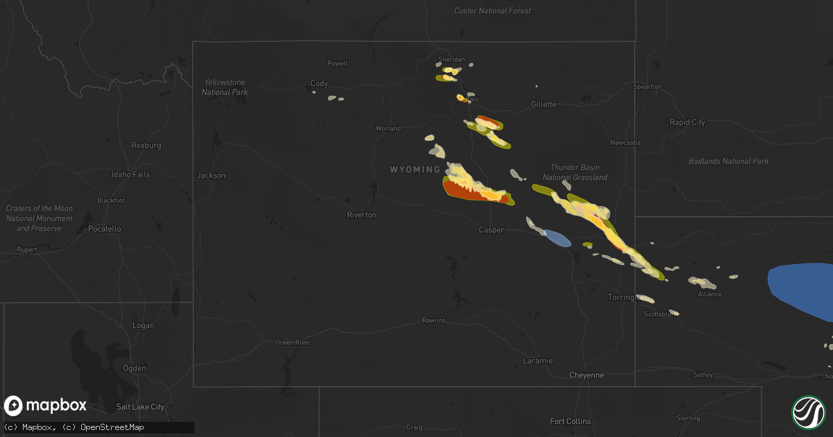
Hail Map in Wyoming on July 6, 2023
Get this storm
July 6 map
$229
one time, instant access
Download today. No call, no setup
Keep the $229
Bought the map and want the full workflow? Apply the entire $229 to a subscription within 7 days. None of it is wasted.
Every map, not just this one
This buys you this map. Subscription and you get every map we run, in the markets you choose from a few cities to whole states to nationwide. Plus real-time alerts the moment a storm fires.
Contact data
Name, contact info, occupancy, even credit band for addresses in the footprint. You go from where it hit to who to call.
Become the source they trust
Unlimited branding weather history reports on demand. You already have the documented answer ready for the property owner, and you are the one who showed up with it.
Property data and RoofTrace estimates
Pull up any address you have got, its value and the exact code rules for that jurisdiction, straight from One Click Code. Then RoofTrace estimates the squares, pitch, and roof value, priced the way you price.
Storm reports in Wyoming
Wyoming
| Date | Description |
|---|---|
| 07/06/20235:40 PM CDT | Hail of nickel to ping pong ball size reported along wyoming highway 259 about 3 to 5 miles north of the i-25 interchange. |
| 07/06/20234:46 PM CDT | Mesonet station wy34 1.8 sw leroy |
| 07/06/20234:37 PM CDT | A local report indicates 1.75 inch wind near 2 W Story |
| 07/06/20234:32 PM CDT | Mainly pea to nickel with a few half dollar |
| 07/06/20234:19 PM CDT | A lot of quarter sized hail and very heavy rain. |
| 07/06/20233:10 PM CDT | A local report indicates 1.25 inch wind near Buffalo |
| 07/06/20233:10 PM CDT | Public report relayed through em. |
| 07/05/202311:13 PM CDT | Asos station kdgw douglas airport - dgw. |
| 07/05/202310:35 PM CDT | 75 mph winds and half dollar size hail. |
| 07/05/202310:30 PM CDT | Delayed report. Cocorahs report on 2 inch hail 12.1n manville. Resulted in damage to cars and roof shingles. |
| 07/05/202310:25 PM CDT | A local report indicates 1.75 inch wind near 2 N Lusk |
| 07/05/202310:20 PM CDT | A local report indicates 1.25 inch wind near 3 NNE Lusk |
| 07/05/202310:20 PM CDT | Quarter size hail between mm153 and mm155. |
| 07/05/202310:20 PM CDT | A local report indicates 75 MPH wind near 7 ESE Lusk |
| 07/05/20239:37 PM CDT | Hail ranging from the size of nickels to ping pong balls reported along interstate 25. |
| 07/05/20239:33 PM CDT | Near exit 210 on interstate 25. |
| 07/05/20239:02 PM CDT | Golf ball sized hail and 40 to 50 mph wind gusts. |
| 07/05/20239:02 PM CDT | A local report indicates 1.75 inch wind near 22 N Natrona |
All States Impacted by Hail Map on July 6, 2023
Cities Impacted by Hail Map on July 6, 2023
- Johnson, KS
- Conchas Dam, NM
- Tucumcari, NM
- Sidney, NE
- Peetz, CO
- Sugar City, CO
- Ordway, CO
- Manzanola, CO
- Las Animas, CO
- La Junta, CO
- Cheraw, CO
- Rocky Ford, CO
- Swink, CO
- Olney Springs, CO
- Crowley, CO
- Chandler, OK
- Detroit, TX
- Rattan, OK
- Fort Morgan, CO
- Woodrow, CO
- Bokoshe, OK
- Shady Point, OK
- Stroud, OK
- Ringold, OK
- Gurdon, AR
- Broken Bow, OK
- Depew, OK
- Paden, OK
- Sparks, OK
- Summerville, GA
- Buffalo, WY
- Kaycee, WY
- Sheridan, WY
- Big Horn, WY
- Story, WY
- Corona, NM
- Vaughn, NM
- Rapid City, SD
- Clearmont, WY
- Clarksville, TN
- Ashland City, TN
- Eclectic, AL
- Sweetwater, TX
- Banner, WY
- Martinsdale, MT
- Calhoun, LA
- West Monroe, LA
- Casper, WY
- Ranger, TX
- Caddo, TX
- Breckenridge, TX
- Cisco, TX
- Hope, AR
- Sandy Hook, MS
- Malvern, AR
- Mineral Springs, AR
- Texarkana, TX
- Marshall, TX
- De Berry, TX
- Nashville, AR
- Idabel, OK
- Emmet, AR
- Crossett, AR
- Boulder, MT
- Parker, CO
- Lockesburg, AR
- De Queen, AR
- Honey Grove, TX
- Telephone, TX
- Gillette, WY
- Cedar Hill, TN
- Ida, LA
- Plain Dealing, LA
- Coushatta, LA
- Blossom, TX
- Aliceville, AL
- West Palm Beach, FL
- Bastrop, LA
- Hooks, TX
- Hamburg, AR
- Charlotte, TN
- Huntsville, TX
- Oakhurst, TX
- Rockledge, FL
- Cocoa, FL
- Douglas, WY
- Lander, WY
- Big Piney, WY
- Thatcher, ID
- Riverton, WY
- Boulder, WY
- Downey, ID
- Malad City, ID
- Montpelier, ID
- Holbrook, ID
- Preston, ID
- Shoshoni, WY
- Pinedale, WY
- Fruita, CO
- Glade Park, CO
- Shonto, AZ
- Loma, CO
- Monticello, UT
- Hanna, WY
- Craig, CO
- Rifle, CO
- Blanding, UT
- De Beque, CO
- Mexican Hat, UT
- Dixon, WY
- Flagstaff, AZ
- Saratoga, WY
- Monument Valley, UT
- Maybell, CO
- Meeker, CO
- Glenrock, WY
- Tuba City, AZ
- Kaibeto, AZ
- Rawlins, WY
- Savery, WY
- Dinosaur, CO
- Moab, UT
- Lake Powell, UT
- Hugo, CO
- Karval, CO
- Ramah, CO
- Haswell, CO
- Kit Carson, CO
- Lance Creek, WY
- Shawnee, WY
- Lusk, WY
- Lost Springs, WY
- Manville, WY
- Eads, CO
- Wiley, CO
- Rush, CO
- Limon, CO
- Arlington, CO
- Van Tassell, WY
- Torrington, WY
- Lamar, CO
- Holly, CO
- McClave, CO
- Granada, CO
- Hasty, CO
- Weskan, KS
- Sharon Springs, KS
- Harrison, NE
- Cheyenne Wells, CO
- Pine Ridge, SD
- Milroy, PA
- McClure, PA
- Rhame, ND
- Scooba, MS
- Crosby, MS
- Kyle, SD
- Gordo, AL
- Strasburg, CO
- Lumberton, MS
- Wiggins, MS
- Camp Crook, SD
- Ten Sleep, WY
- Cody, WY
- Alpine, AL
- Meeteetse, WY
- Talladega, AL
- Williamsport, PA
- Bennett, CO
- Tribune, KS
- Olla, LA
- Aimwell, LA
- Roggen, CO
- Onida, SD
- Cloudcroft, NM
- Lisman, AL
- Greensburg, LA
- Alzada, MT
- Newark, TX
- Ferriday, LA
- Vidalia, LA
- Lavina, MT
- Bridger, MT
- Sylacauga, AL
- Childersburg, AL
- Castor, LA
- Ashland, LA
- Tillar, AR
- Natchez, MS
- Sparta, GA
- Sandersville, GA
- Saline, LA
- Wesson, MS
- Tylertown, MS
- Elizabeth, CO
- Weogufka, AL
- Rockford, AL
- Goodwater, AL
- Union Center, SD
- Roundup, MT
- Arapahoe, CO
- Jachin, AL
- Perkinston, MS
- Hartselle, AL
- Macon, MS
- Milledgeville, GA
- Satanta, KS
- Kismet, KS
- Plains, KS
- Liberal, KS
- Meade, KS
- Forgan, OK
- Beaver, OK
- Ulysses, KS
- Moscow, KS
- Hugoton, KS
- Manter, KS
- Syracuse, KS
- Two Buttes, CO
- Walsh, CO
- Springfield, CO
- Lakin, KS
- Kendall, KS
- Marsland, NE
- Hemingford, NE
- Wallace, KS
- Brewster, KS
- Edson, KS
- Colby, KS
- Levant, KS
- Merriman, NE
- Whitman, NE
- Ashby, NE
- Cody, NE
- Valentine, NE
- Thedford, NE
- Seneca, NE
- Mullen, NE
- Johnstown, NE
- Purdum, NE
- Halsey, NE
- Stapleton, NE
- Hyannis, NE
- Laverne, OK
- Gate, OK
- Follett, TX
- Darrouzett, TX
- Balko, OK
- Tyrone, OK
- Rolla, KS
- Richfield, KS
- Hooker, OK
- Turpin, OK
- May, OK
- Booker, TX
- Shattuck, OK
- Fargo, OK
- Elkhart, KS
- Arnett, OK
- Perryton, TX
- Buffalo, OK
- Woodward, OK
- Fort Supply, OK
- Higgins, TX
- Lipscomb, TX
- Sharon, OK
- Gage, OK
- Mooreland, OK
- Chester, OK
- Vici, OK
- Fairview, OK
- Mutual, OK
- Clinton, OK
- Putnam, OK
- Taloga, OK
- Crawford, OK
- Custer City, OK
- Seiling, OK
- Camargo, OK
- Hammon, OK
- Butler, OK
- Leedey, OK
- Cheyenne, OK
- Miami, TX
- Canadian, TX
- Durham, OK
- Oakwood, OK
- Canton, OK
- Thomas, OK
- Watonga, OK
- Fay, OK
- Ellsworth, NE
- Ozan, AR
- Pierre, SD
- Goodland, KS
- Jay Em, WY
- Montoursville, PA
- El Dorado, AR
- Sheridan Lake, CO
- Sublette, KS
- Stromsburg, NE
- Polk, NE
- Woodville, MS
- Success, AR
- Winona, KS
- Ashdown, AR
- Glendo, WY
- Wilmot, AR
- Crumrod, AR
- Butler, AL
- Morrill, NE
- Camden, AR
- Winchester, AR
- Fulton, AR
- Washington, AR
- Rosston, AR
- Stephens, AR
- Harrisonburg, LA
- Hordville, NE
- Central City, NE
- Clarks, NE
- Hay Springs, NE
- Stratton, CO
- Monticello, AR
- Prescott, AR
- Alliance, NE
- Wilton, AR
- Montrose, AR
- Quinter, KS
- Park, KS
- Hampton, AR
- Ogden, AR
- Texarkana, AR
- Poplarville, MS
- Blevins, AR
- Naylor, MO
- Longdale, OK
- Arapaho, OK
- Foss, OK
- Weatherford, OK
- Geary, OK
- Corn, OK
- Lakeview, TX
- Memphis, TX
- Canute, OK
- Hollis, OK
- Willow, OK
- Sayre, OK
- Carter, OK
- Wellington, TX
- Dill City, OK
- Greenfield, OK
- Minatare, NE
- Guymon, OK
- Monument, KS
- Mitchell, NE
- Englewood, KS
- North Platte, NE
- Tryon, NE
- Monroe, NE
- Bayard, NE
- Rosston, OK
- Oakley, KS
- Fouke, AR
- Haworth, OK
- Ord, NE
- Elk City, OK
- Gresham, NE
- Maxwell, NE
- Reydon, OK
- Cordell, OK


