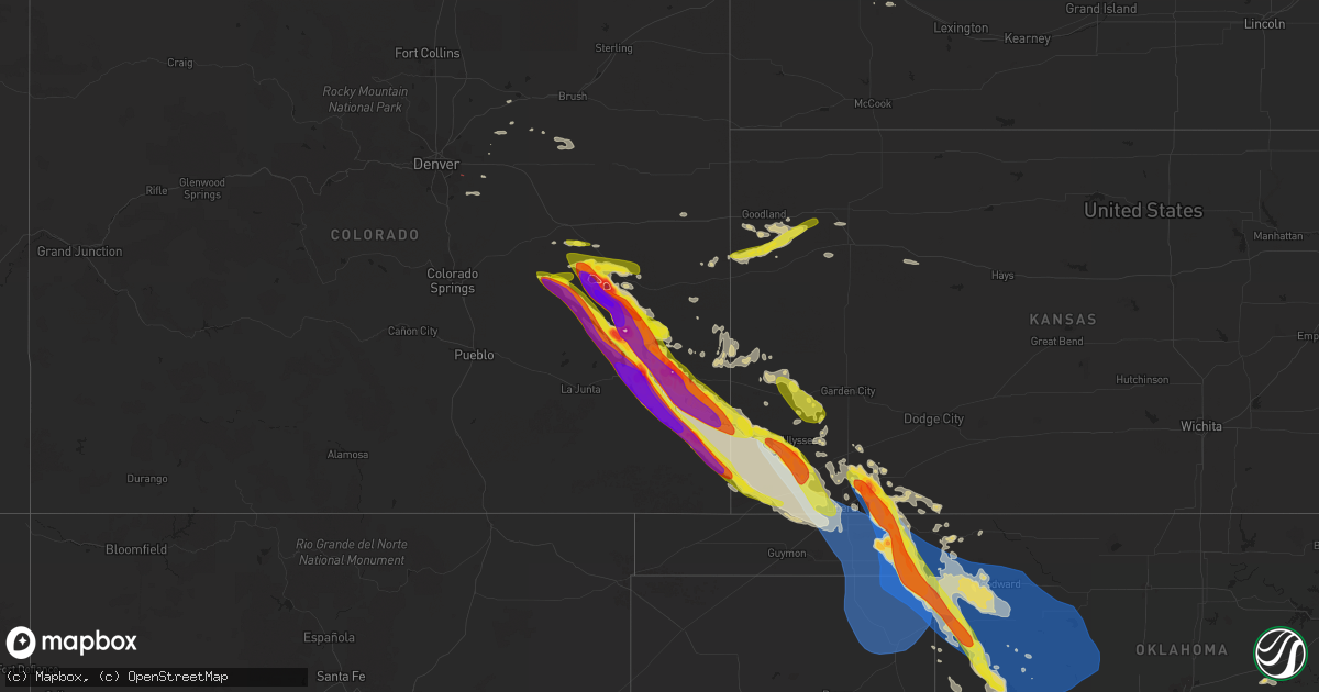
Hail Map on July 6, 2023
Get this storm
July 6 map
$229
one time, instant access
Download today. No call, no setup
Keep the $229
Bought the map and want the full workflow? Apply the entire $229 to a subscription within 7 days. None of it is wasted.
Every map, not just this one
This buys you this map. Subscription and you get every map we run, in the markets you choose from a few cities to whole states to nationwide. Plus real-time alerts the moment a storm fires.
Contact data
Name, contact info, occupancy, even credit band for addresses in the footprint. You go from where it hit to who to call.
Become the source they trust
Unlimited branding weather history reports on demand. You already have the documented answer ready for the property owner, and you are the one who showed up with it.
Property data and RoofTrace estimates
Pull up any address you have got, its value and the exact code rules for that jurisdiction, straight from One Click Code. Then RoofTrace estimates the squares, pitch, and roof value, priced the way you price.
States Impacted by Hail Map on July 6, 2023
Storm reports
Oklahoma
| Date | Description |
|---|---|
| 07/06/20235:45 AM CDT | Seiling |
| 07/06/20235:00 AM CDT | Roof blown off the mutual fire department building. Time estimated via radar. |
| 07/06/20234:55 AM CDT | Kwwr. |
| 07/06/20234:50 AM CDT | Multiple large |
| 07/06/20234:45 AM CDT | Woodward |
| 07/06/20234:35 AM CDT | Numerous power poles and lines down in the vicinity. Time estimated via radar. |
| 07/06/20234:20 AM CDT | Multiple power poles snapped in the vicinity. Time estimated via radar. |
| 07/06/20234:20 AM CDT | 40-ft tall tree... 18 inches in diameter... Snapped near the base. Time estimated via radar. |
| 07/06/20234:18 AM CDT | Time estimated via radar. |
| 07/06/20233:30 AM CDT | A local report indicates 62 MPH wind near 8 W Slapout |
| 07/06/20233:03 AM CDT | A local report indicates 1.75 inch wind near 5 S Beaver |
| 07/06/20233:03 AM CDT | A metal outbuilding was destroyed in beaver. Multiple power lines were downed between forgan and beaver. |
| 07/06/20233:00 AM CDT | A local report indicates 83 MPH wind near 1 SSW Beaver |
| 07/06/20232:55 AM CDT | Thunderstorm wind gusts estimated to be 70 to 80 mph. Tree limbs downed in forgan. Hail up to the size of dimes also reported. |
Maryland
| Date | Description |
|---|---|
| 07/06/20231:10 PM CDT | Several trees and branches blew down near watersville... Including near the intersection of flag marsh road and watersville road... Watersville road and gillis falls ro |
Alabama
| Date | Description |
|---|---|
| 07/06/20235:26 PM CDT | Powerlines down. Time estimated based on radar. |
| 07/06/20234:09 PM CDT | Minor roof damage to five points grocery and some small trees down in the immediate vicinity. Time estimated based on radar. |
| 07/06/20233:52 PM CDT | Powerlines and trees knocked down in the 1700 block of county road 87. Time estimated based on radar. |
| 07/06/20232:58 PM CDT | A few trees were blown down around vernon... With a couple falling power lines. |
Kansas
| Date | Description |
|---|---|
| 07/06/20233:33 AM CDT | A local report indicates 1.00 inch wind near Liberal |
| 07/06/20233:26 AM CDT | A local report indicates 60 MPH wind near Liberal |
| 07/06/20232:55 AM CDT | A local report indicates 1.00 inch wind near 7 WSW Richfield |
| 07/06/20232:34 AM CDT | A local report indicates 1.00 inch wind near 9 WNW Moscow |
| 07/06/20232:30 AM CDT | A local report indicates 2.00 inch wind near Kismet |
| 07/06/20232:30 AM CDT | A local report indicates 70 MPH wind near Kismet |
| 07/06/20232:21 AM CDT | A local report indicates 1.75 inch wind near 7 S Ulysses |
| 07/06/20232:15 AM CDT | Awos station kjhn johnson city. |
| 07/06/202312:25 AM CDT | A local report indicates 58 MPH wind near 6 E Tribune |
| 07/06/202312:00 AM CDT | Time and location approximate... Based on radar. |
Nebraska
| Date | Description |
|---|---|
| 07/06/20233:20 AM CDT | Delayed report of 60 to 70 mph thunderstorm winds. |
| 07/05/202311:55 PM CDT | A local report indicates 1.00 inch wind near 2 W Agate |
Utah
| Date | Description |
|---|---|
| 07/06/20231:00 AM CDT | Mesonet station gni 8.5 n lakeside |
Pennsylvania
| Date | Description |
|---|---|
| 07/06/20236:01 PM CDT | Large tree down on sardis rd. Time estimated based on radar. |
| 07/06/20236:01 PM CDT | Large tree down along greensburg rd. Estimated time indicated by radar. |
| 07/06/20236:01 PM CDT | Trees reported down near drennen rd. Estimated time indicated by radar. |
| 07/06/20235:50 PM CDT | Approx 30 to 40 trees down around mt eagle rd and on the bald eagle train tracks. Time estimated from radar. |
| 07/06/20235:20 PM CDT | Damaged awning... Punctured roof... And several trees down along garriston rd near the intersection with pa-382 in newberry township. |
| 07/06/20233:54 PM CDT | Roof blown off of a barn near intersection of west and maple roads in cussewago township. Time estimated via radar. |
| 07/06/20233:47 PM CDT | Several trees down in hayfield township. |
| 07/05/20238:10 PM CDT | A local report indicates 58 MPH wind near Williamsport Airport |
| 07/05/20238:00 PM CDT | Powerlines down causing outages for over 700 individuals. |
| 07/05/20237:25 PM CDT | Trees down. Structural damage to barn... Gates... And fencing. Report relayed via social media. |
| 07/05/20237:05 PM CDT | Trees down on powerlines. |
| 07/05/20237:00 PM CDT | Report of power line down along the 7600 block of franklin road. Time estimated based on radar. |
Colorado
| Date | Description |
|---|---|
| 07/06/20234:56 PM CDT | Landspout tornado near front range airport. Has been on the ground for 2 to 3 minutes. |
| 07/06/20234:52 PM CDT | Landspout tornado near front range airport. Was on the ground for 3 to 4 minutes. |
| 07/06/20234:52 PM CDT | Corrects previous tornado report from 5 e denver intl airport. Landspout tornado near front range airport. Was on the ground for 3 to 4 minutes. |
| 07/06/20234:29 PM CDT | Tornado threw a 1400 pound disk 100 yards. |
| 07/06/20231:52 AM CDT | A local report indicates 2.00 inch wind near 1 N Two Buttes |
| 07/06/202312:39 AM CDT | A local report indicates 2.00 inch wind near 3 E Hasty |
| 07/06/202312:20 AM CDT | Report from mping: baseball |
| 07/06/202312:19 AM CDT | A local report indicates 2.50 inch wind near 1 SE Hasty |
| 07/06/202312:15 AM CDT | Photo relayed from broadcast media via social media. |
| 07/06/202312:09 AM CDT | Photo relayed via social media. |
| 07/05/202311:27 PM CDT | Report from mping: ping pong ball |
| 07/05/202311:26 PM CDT | Report from mping: ping pong ball |
| 07/05/202311:20 PM CDT | Hail has been ongoing for 10 minutes and has been getting bigger. |
| 07/05/202311:19 PM CDT | At least quarter sized hail which broke a large picture window. |
| 07/05/202311:15 PM CDT | Report from mping: hen egg |
| 07/05/202311:10 PM CDT | Corrects previous hail report from lamar. Ping pong to baseball sized hail in lamar reported by law enforcement. |
| 07/05/202311:10 PM CDT | Ping pong to baseball sized hail in lamver reported by law enforcement. |
| 07/05/202310:56 PM CDT | Report from mping: ping pong ball |
| 07/05/202310:55 PM CDT | Relayed via broadcast media. |
| 07/05/202310:54 PM CDT | A local report indicates 1.25 inch wind near 3 NE Wiley |
| 07/05/202310:44 PM CDT | Klaa asos. |
| 07/05/202310:41 PM CDT | Report from mping: half dollar |
| 07/05/202310:11 PM CDT | 2.5 to 3 inch hail photos via social media. |
| 07/05/20239:50 PM CDT | A local report indicates 2.00 inch wind near Haswell |
| 07/05/20239:49 PM CDT | Relayed by broadcast media with photo via social media. |
| 07/05/20239:43 PM CDT | Report from mping: golf ball |
| 07/05/20239:25 PM CDT | Report from mping: quarter |
| 07/05/20239:05 PM CDT | A local report indicates 2.00 inch wind near 9 NNE Karval |
| 07/05/20239:00 PM CDT | A local report indicates 4.00 inch wind near 13 E Karval |
| 07/05/20238:55 PM CDT | Report from mping: hen egg+ |
| 07/05/20238:52 PM CDT | A local report indicates 2.50 inch wind near 8 NNE Karval |
| 07/05/20238:50 PM CDT | A local report indicates 3.50 inch wind near 9 SW Boyero |
Montana
| Date | Description |
|---|---|
| 07/06/20231:29 PM CDT | Hail estimated up to quarter size. |
Arkansas
| Date | Description |
|---|---|
| 07/06/20236:29 PM CDT | Awning of a gas station displaced in monticello. Winds estimated by radar to be 45 to 50 mph. |
Missouri
| Date | Description |
|---|---|
| 07/05/20239:43 PM CDT | Large tree down on power lines in senath. Power is out across much of town. |
Louisiana
| Date | Description |
|---|---|
| 07/06/20236:34 PM CDT | Tree downed along hwy 126 near sandy lake. Time estimated based on radar. |
| 07/05/20237:08 PM CDT | Powerlines downed at hwy 84/hwy 425 in vidalia near sprint mart. Time estimated based on radar. |
| 07/05/20237:03 PM CDT | Tree downed by crawford welding. Time estimated based on radar. |
| 07/05/20237:00 PM CDT | Tree fell on a powerline... Causing a fire. Time estimated based on radar. |
Virginia
| Date | Description |
|---|---|
| 07/05/20239:27 PM CDT | A few trees reported down in western albemarle county |
| 07/05/20237:50 PM CDT | Report of trees down and an outbuilding destroyed in mt. Crawford |
| 07/05/20237:49 PM CDT | There were several reports of trees... Tree limbs and wires blown down in bridgewater... Including on east college street. |
North Carolina
| Date | Description |
|---|---|
| 07/06/20234:24 PM CDT | Tree fell on truck. |
| 07/06/20233:02 PM CDT | Fallen trees/limbs damaged power equipment. |
| 07/06/20232:40 PM CDT | Tree down on pond rd near alamance rd. |
Wyoming
| Date | Description |
|---|---|
| 07/06/20235:40 PM CDT | Hail of nickel to ping pong ball size reported along wyoming highway 259 about 3 to 5 miles north of the i-25 interchange. |
| 07/06/20234:46 PM CDT | Mesonet station wy34 1.8 sw leroy |
| 07/06/20234:37 PM CDT | A local report indicates 1.75 inch wind near 2 W Story |
| 07/06/20234:32 PM CDT | Mainly pea to nickel with a few half dollar |
| 07/06/20234:19 PM CDT | A lot of quarter sized hail and very heavy rain. |
| 07/06/20233:10 PM CDT | Public report relayed through em. |
| 07/06/20233:10 PM CDT | A local report indicates 1.25 inch wind near Buffalo |
| 07/05/202311:13 PM CDT | Asos station kdgw douglas airport - dgw. |
| 07/05/202310:35 PM CDT | 75 mph winds and half dollar size hail. |
| 07/05/202310:30 PM CDT | Delayed report. Cocorahs report on 2 inch hail 12.1n manville. Resulted in damage to cars and roof shingles. |
| 07/05/202310:25 PM CDT | A local report indicates 1.75 inch wind near 2 N Lusk |
| 07/05/202310:20 PM CDT | A local report indicates 75 MPH wind near 7 ESE Lusk |
| 07/05/202310:20 PM CDT | A local report indicates 1.25 inch wind near 3 NNE Lusk |
| 07/05/202310:20 PM CDT | Quarter size hail between mm153 and mm155. |
| 07/05/20239:37 PM CDT | Hail ranging from the size of nickels to ping pong balls reported along interstate 25. |
| 07/05/20239:33 PM CDT | Near exit 210 on interstate 25. |
| 07/05/20239:02 PM CDT | A local report indicates 1.75 inch wind near 22 N Natrona |
| 07/05/20239:02 PM CDT | Golf ball sized hail and 40 to 50 mph wind gusts. |
Cities Impacted by Hail Map on July 6, 2023
- Johnson, KS
- Conchas Dam, NM
- Tucumcari, NM
- Sidney, NE
- Peetz, CO
- Sugar City, CO
- Ordway, CO
- Manzanola, CO
- Las Animas, CO
- La Junta, CO
- Cheraw, CO
- Rocky Ford, CO
- Swink, CO
- Olney Springs, CO
- Crowley, CO
- Chandler, OK
- Detroit, TX
- Rattan, OK
- Fort Morgan, CO
- Woodrow, CO
- Bokoshe, OK
- Shady Point, OK
- Stroud, OK
- Ringold, OK
- Gurdon, AR
- Broken Bow, OK
- Depew, OK
- Paden, OK
- Sparks, OK
- Summerville, GA
- Buffalo, WY
- Kaycee, WY
- Sheridan, WY
- Big Horn, WY
- Story, WY
- Corona, NM
- Vaughn, NM
- Rapid City, SD
- Clearmont, WY
- Clarksville, TN
- Ashland City, TN
- Eclectic, AL
- Sweetwater, TX
- Banner, WY
- Martinsdale, MT
- Calhoun, LA
- West Monroe, LA
- Casper, WY
- Ranger, TX
- Caddo, TX
- Breckenridge, TX
- Cisco, TX
- Hope, AR
- Sandy Hook, MS
- Malvern, AR
- Mineral Springs, AR
- Texarkana, TX
- Marshall, TX
- De Berry, TX
- Nashville, AR
- Idabel, OK
- Emmet, AR
- Crossett, AR
- Boulder, MT
- Parker, CO
- Lockesburg, AR
- De Queen, AR
- Honey Grove, TX
- Telephone, TX
- Gillette, WY
- Cedar Hill, TN
- Ida, LA
- Plain Dealing, LA
- Coushatta, LA
- Blossom, TX
- Aliceville, AL
- West Palm Beach, FL
- Bastrop, LA
- Hooks, TX
- Hamburg, AR
- Charlotte, TN
- Huntsville, TX
- Oakhurst, TX
- Rockledge, FL
- Cocoa, FL
- Douglas, WY
- Lander, WY
- Big Piney, WY
- Thatcher, ID
- Riverton, WY
- Boulder, WY
- Downey, ID
- Malad City, ID
- Montpelier, ID
- Holbrook, ID
- Preston, ID
- Shoshoni, WY
- Pinedale, WY
- Fruita, CO
- Glade Park, CO
- Shonto, AZ
- Loma, CO
- Monticello, UT
- Hanna, WY
- Craig, CO
- Rifle, CO
- Blanding, UT
- De Beque, CO
- Mexican Hat, UT
- Dixon, WY
- Flagstaff, AZ
- Saratoga, WY
- Monument Valley, UT
- Maybell, CO
- Meeker, CO
- Glenrock, WY
- Tuba City, AZ
- Kaibeto, AZ
- Rawlins, WY
- Savery, WY
- Dinosaur, CO
- Moab, UT
- Lake Powell, UT
- Hugo, CO
- Karval, CO
- Ramah, CO
- Haswell, CO
- Kit Carson, CO
- Lance Creek, WY
- Shawnee, WY
- Lusk, WY
- Lost Springs, WY
- Manville, WY
- Eads, CO
- Wiley, CO
- Rush, CO
- Limon, CO
- Arlington, CO
- Van Tassell, WY
- Torrington, WY
- Lamar, CO
- Holly, CO
- McClave, CO
- Granada, CO
- Hasty, CO
- Weskan, KS
- Sharon Springs, KS
- Harrison, NE
- Cheyenne Wells, CO
- Pine Ridge, SD
- Milroy, PA
- McClure, PA
- Rhame, ND
- Scooba, MS
- Crosby, MS
- Kyle, SD
- Gordo, AL
- Strasburg, CO
- Lumberton, MS
- Wiggins, MS
- Camp Crook, SD
- Ten Sleep, WY
- Cody, WY
- Alpine, AL
- Meeteetse, WY
- Talladega, AL
- Williamsport, PA
- Bennett, CO
- Tribune, KS
- Olla, LA
- Aimwell, LA
- Roggen, CO
- Onida, SD
- Cloudcroft, NM
- Lisman, AL
- Greensburg, LA
- Alzada, MT
- Newark, TX
- Ferriday, LA
- Vidalia, LA
- Lavina, MT
- Bridger, MT
- Sylacauga, AL
- Childersburg, AL
- Castor, LA
- Ashland, LA
- Tillar, AR
- Natchez, MS
- Sparta, GA
- Sandersville, GA
- Saline, LA
- Wesson, MS
- Tylertown, MS
- Elizabeth, CO
- Weogufka, AL
- Rockford, AL
- Goodwater, AL
- Union Center, SD
- Roundup, MT
- Arapahoe, CO
- Jachin, AL
- Perkinston, MS
- Hartselle, AL
- Macon, MS
- Milledgeville, GA
- Satanta, KS
- Kismet, KS
- Plains, KS
- Liberal, KS
- Meade, KS
- Forgan, OK
- Beaver, OK
- Ulysses, KS
- Moscow, KS
- Hugoton, KS
- Manter, KS
- Syracuse, KS
- Two Buttes, CO
- Walsh, CO
- Springfield, CO
- Lakin, KS
- Kendall, KS
- Marsland, NE
- Hemingford, NE
- Wallace, KS
- Brewster, KS
- Edson, KS
- Colby, KS
- Levant, KS
- Merriman, NE
- Whitman, NE
- Ashby, NE
- Cody, NE
- Valentine, NE
- Thedford, NE
- Seneca, NE
- Mullen, NE
- Johnstown, NE
- Purdum, NE
- Halsey, NE
- Stapleton, NE
- Hyannis, NE
- Laverne, OK
- Gate, OK
- Follett, TX
- Darrouzett, TX
- Balko, OK
- Tyrone, OK
- Rolla, KS
- Richfield, KS
- Hooker, OK
- Turpin, OK
- May, OK
- Booker, TX
- Shattuck, OK
- Fargo, OK
- Elkhart, KS
- Arnett, OK
- Perryton, TX
- Buffalo, OK
- Woodward, OK
- Fort Supply, OK
- Higgins, TX
- Lipscomb, TX
- Sharon, OK
- Gage, OK
- Mooreland, OK
- Chester, OK
- Vici, OK
- Fairview, OK
- Mutual, OK
- Clinton, OK
- Putnam, OK
- Taloga, OK
- Crawford, OK
- Custer City, OK
- Seiling, OK
- Camargo, OK
- Hammon, OK
- Butler, OK
- Leedey, OK
- Cheyenne, OK
- Miami, TX
- Canadian, TX
- Durham, OK
- Oakwood, OK
- Canton, OK
- Thomas, OK
- Watonga, OK
- Fay, OK
- Ellsworth, NE
- Ozan, AR
- Pierre, SD
- Goodland, KS
- Jay Em, WY
- Montoursville, PA
- El Dorado, AR
- Sheridan Lake, CO
- Sublette, KS
- Stromsburg, NE
- Polk, NE
- Woodville, MS
- Success, AR
- Winona, KS
- Ashdown, AR
- Glendo, WY
- Wilmot, AR
- Crumrod, AR
- Butler, AL
- Morrill, NE
- Camden, AR
- Winchester, AR
- Fulton, AR
- Washington, AR
- Rosston, AR
- Stephens, AR
- Harrisonburg, LA
- Hordville, NE
- Central City, NE
- Clarks, NE
- Hay Springs, NE
- Stratton, CO
- Monticello, AR
- Prescott, AR
- Alliance, NE
- Wilton, AR
- Montrose, AR
- Quinter, KS
- Park, KS
- Hampton, AR
- Ogden, AR
- Texarkana, AR
- Poplarville, MS
- Blevins, AR
- Naylor, MO
- Longdale, OK
- Arapaho, OK
- Foss, OK
- Weatherford, OK
- Geary, OK
- Corn, OK
- Lakeview, TX
- Memphis, TX
- Canute, OK
- Hollis, OK
- Willow, OK
- Sayre, OK
- Carter, OK
- Wellington, TX
- Dill City, OK
- Greenfield, OK
- Minatare, NE
- Guymon, OK
- Monument, KS
- Mitchell, NE
- Englewood, KS
- North Platte, NE
- Tryon, NE
- Monroe, NE
- Bayard, NE
- Rosston, OK
- Oakley, KS
- Fouke, AR
- Haworth, OK
- Ord, NE
- Elk City, OK
- Gresham, NE
- Maxwell, NE
- Reydon, OK
- Cordell, OK