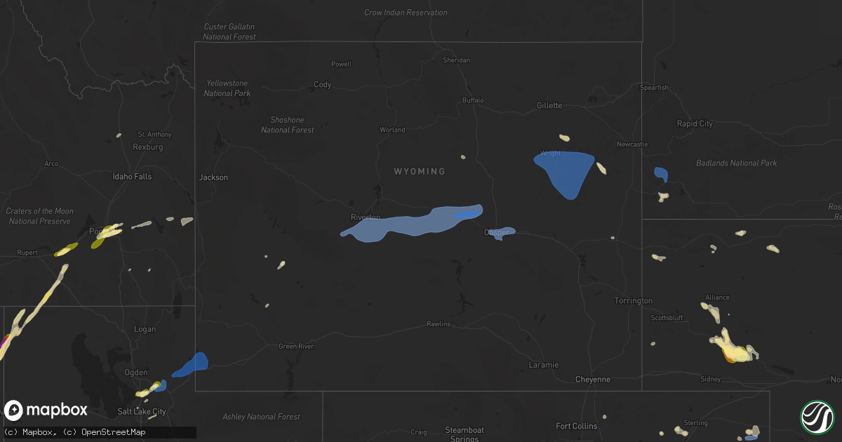
Hail Map in Wyoming on July 4, 2025
Get this storm
July 4 map
$229
one time, instant access
Download today. No call, no setup
Keep the $229
Bought the map and want the full workflow? Apply the entire $229 to a subscription within 7 days. None of it is wasted.
Every map, not just this one
This buys you this map. Subscription and you get every map we run, in the markets you choose from a few cities to whole states to nationwide. Plus real-time alerts the moment a storm fires.
Contact data
Name, contact info, occupancy, even credit band for addresses in the footprint. You go from where it hit to who to call.
Become the source they trust
Unlimited branding weather history reports on demand. You already have the documented answer ready for the property owner, and you are the one who showed up with it.
Property data and RoofTrace estimates
Pull up any address you have got, its value and the exact code rules for that jurisdiction, straight from One Click Code. Then RoofTrace estimates the squares, pitch, and roof value, priced the way you price.
Storm reports in Wyoming
Wyoming
| Date | Description |
|---|---|
| 07/04/20256:52 PM CDT | Mesonet station wy61 i25 - hat six. |
| 07/04/20256:50 PM CDT | Claude creek... Wy pacificorp site. |
| 07/04/20256:50 PM CDT | Scenic drive... Wy pacificorp site. |
| 07/04/20256:50 PM CDT | Casper mountain road... Wy pacificorp site. |
| 07/04/20256:50 PM CDT | Mesonet station pc576 horse ranch creek. |
| 07/04/20256:42 PM CDT | Wy dot weather sensor. |
| 07/04/20256:42 PM CDT | Wy dot weather sensor. |
| 07/04/20256:20 PM CDT | Mesonet station rsnw4 hiland 16 s... Time estimate... Fales rock. |
| 07/04/20256:12 PM CDT | Wy dot weather station. |
| 07/04/20256:00 PM CDT | Mesonet station pc457 hidden dome. |
| 07/04/20255:47 PM CDT | Wy dot weather sensor. |
| 07/04/20255:40 PM CDT | Time and location estimate; trees and powerlines down. |
| 07/04/20255:40 PM CDT | 5 inch diameter tree branch fell on house... Report from trained spotter. Location approximate. |
| 07/04/20255:21 PM CDT | Asos station kgey greybull airport. |
| 07/04/20254:40 PM CDT | At nws riverton wfo... Measured gust from onsite weather station. |
| 07/04/20254:30 PM CDT | Pavilion... Wy cwop site. |
| 07/04/20254:27 PM CDT | A local report indicates 58 MPH wind near 1 S Lander |
| 07/03/20259:44 PM CDT | A local report indicates 58 MPH wind near 11 NE Morrisey |
| 07/03/20259:06 PM CDT | A local report indicates 60 MPH wind near 7 NNE Rochelle |
| 07/03/20258:34 PM CDT | A local report indicates 72 MPH wind near 1 N Wright |
| 07/03/20258:24 PM CDT | Corrects previous tstm wnd gst report from 8 ne bill to add staion information. Umrb station dcmw4 |
| 07/03/20258:24 PM CDT | Corrects previous tstm wnd gst report from 8 ne bill to add staion information. Um |
| 07/03/20258:00 PM CDT | Measured at the first divide wyoming dot rwis site. |
| 07/03/20258:00 PM CDT | Measured at the first divide wyoming dot |
| 07/03/20257:50 PM CDT | Measured at the evanston uinta county airport burns field asos. |
| 07/03/20257:20 PM CDT | Mesonet station pc602 glen rock rolling hills. |
All States Impacted by Hail Map on July 4, 2025
Cities Impacted by Hail Map on July 4, 2025
- Grand Marais, MN
- Williams, MN
- New Brockton, AL
- Enterprise, AL
- Baudette, MN
- Daleville, AL
- Usaf Academy, CO
- Colorado Springs, CO
- Adrian, OR
- Chancellor, AL
- Murphy, ID
- Jordan Valley, OR
- Ashley, ND
- Zephyrhills, FL
- Geneva, AL
- Coffee Springs, AL
- Gackle, ND
- Grady, AL
- Jamestown, ND
- Luverne, AL
- Samson, AL
- Loman, MN
- Littlefork, MN
- International Falls, MN
- Highland Home, AL
- Edgeley, ND
- Big Piney, WY
- Pinedale, WY
- Chipley, FL
- Bonifay, FL
- Big Falls, MN
- Hope Hull, AL
- Sylacauga, AL
- Kulm, ND
- Hannaford, ND
- Leola, SD
- Wimbledon, ND
- Sanborn, ND
- Cooperstown, ND
- Shelby, AL
- Ypsilanti, ND
- Caryville, FL
- Columbiana, AL
- Spiritwood, ND
- Harrold, SD
- Ipswich, SD
- Birchdale, MN
- Kabetogama, MN
- Orr, MN
- Dazey, ND
- Rogers, ND
- Blunt, SD
- Jud, ND
- Cresbard, SD
- Frederick, SD
- Lowndesboro, AL
- Calera, AL
- Jemison, AL
- Clanton, AL
- Mountain Home, ID
- Prattville, AL
- Millbrook, AL
- Autaugaville, AL
- Boulder, WY
- Ault, CO
- Pierce, CO
- Aberdeen, SD
- Warner, SD
- Mansfield, SD
- Bath, SD
- Columbia, SD
- Luverne, ND
- Valley City, ND
- Oakes, ND
- Montello, NV
- Finley, ND
- Northville, SD
- Montgomery, AL
- East Grand Forks, MN
- Montevallo, AL
- Hope, ND
- Pillsbury, ND
- Clifford, ND
- Portland, ND
- Maplesville, AL
- Thief River Falls, MN
- Brierfield, AL
- Pike Road, AL
- Arlington, CO
- Reynolds, ND
- Wing, ND
- Euclid, MN
- Emerado, ND
- Andrews, NC
- Salt Lake City, UT
- Forsyth, MT
- Robinson, ND
- Grouse Creek, UT
- Park Valley, UT
- Mayville, ND
- Buxton, ND
- Hatton, ND
- Fisher, MN
- Thompson, ND
- Grand Forks, ND
- Carrington, ND
- Hayesville, NC
- Brooklet, GA
- Bessemer, AL
- Marion, AL
- Lawley, AL
- Centreville, AL
- Stanton, ND
- Ismay, MT
- Gladstone, ND
- Salmon, ID
- Leadore, ID
- Beulah, ND
- Kinsey, MT
- Denhoff, ND
- Ontario, OR
- Washburn, ND
- Belfield, ND
- Bowdon, ND
- Wilton, ND
- Mchenry, ND
- Springdale, MT
- Chaseley, ND
- Shepherd, MT
- Grace City, ND
- Richardton, ND
- Zap, ND
- Rapelje, MT
- Dickinson, ND
- Norris, MT
- Sykeston, ND
- Worden, MT
- Dillon, MT
- New Salem, ND
- Wibaux, MT
- Sheridan, MT
- Cascade, ID
- Vale, OR
- Mcclusky, ND
- Gallatin Gateway, MT
- McAllister, MT
- Center, ND
- Broadview, MT
- Reed Point, MT
- Glenfield, ND
- Medora, ND
- Bozeman, MT
- Manning, ND
- Binford, ND
- Sharon, ND
- Alder, MT
- Big Timber, MT
- Goodrich, ND
- Payette, ID
- Beach, ND
- Livingston, MT
- Regan, ND
- Fallon, MT
- Taylor, ND
- Halliday, ND
- Hazen, ND
- Sentinel Butte, ND
- Aneta, ND
- Hurdsfield, ND
- Climax, MN
- McCalla, AL
- West Blocton, AL
- American Falls, ID
- Malta, ID
- Helena, AL
- Elliott, SC
- Lynchburg, SC
- Bishopville, SC
- Mayesville, SC
- Fort Morgan, CO
- Crookston, MN
- Gillette, WY
- Colfax, ND
- Brookwood, AL
- Adger, AL
- Pocatello, ID
- Baxley, GA
- Merino, CO
- Lusk, WY
- Vance, AL
- Sumter, SC
- Declo, ID
- Wewahitchka, FL
- Snyder, CO
- Hazlehurst, GA
- Shoshoni, WY
- Casper, WY
- Hiland, WY
- Quinton, AL
- Park, KS
- Jeffrey City, WY
- Selden, KS
- Terry, MT
- Parrish, AL
- Oakman, AL
- Harrison, NE
- Crane Lake, MN
- Syracuse, KS
- Quinter, KS
- Centerville, UT
- Farmington, UT
- Birmingham, AL
- Mills, WY
- Evansville, WY
- Glenrock, WY
- Yuma, CO
- Haxtun, CO
- Newcastle, WY
- Dryden, TX
- Tribune, KS
- Inkom, ID
- Kaycee, WY
- Kit Carson, CO
- Morgan, UT
- Kaysville, UT
- Bountiful, UT
- Coalville, UT
- Henefer, UT
- Croydon, UT
- Holyoke, CO
- Courtenay, ND
- Grinnell, KS
- Eckley, CO
- Downey, ID
- Three Forks, MT
- Cleveland, ND
- Chadron, NE
- Manter, KS
- Winona, KS
- Wray, CO
- Grace, ID
- Oakley, KS
- Woodruff, UT
- Hay Springs, NE
- Johnson, KS
- Green River, WY
- Soda Springs, ID
- Evanston, WY
- Gove, KS
- Harrisburg, NE
- Alliance, NE
- Cope, CO
- Anton, CO
- Joes, CO
- Kirk, CO
- Wayan, ID
- Rushville, NE
- Angora, NE
- Bridgeport, NE
- Ulysses, KS
- Richfield, KS
- Merriman, NE
- Gordon, NE
- Healy, KS
- Burlington, CO
- Ellsworth, NE
- Broadwater, NE
- Rolla, KS
- Hamer, ID
- Lisco, NE
- Lodgepole, NE
- Oshkosh, NE
- Edgemont, SD
- Custer, SD
- Hot Springs, SD
- Hugoton, KS
- Hooker, OK
- Guymon, OK
- Plains, KS
- Forgan, OK
- Meade, KS
- Peyton, CO
- Calhan, CO
- Lander, WY
- Riverton, WY
- Hudson, WY
- Wright, WY
- Douglas, WY
- Burnet, TX
- Seibert, CO
- Marble Falls, TX


