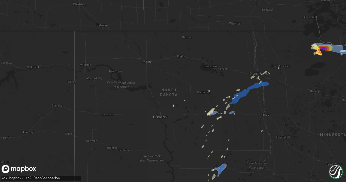
Hail Map in North Dakota on July 4, 2025
Get this storm
July 4 map
$229
one time, instant access
Download today. No call, no setup
Keep the $229
Bought the map and want the full workflow? Apply the entire $229 to a subscription within 7 days. None of it is wasted.
Every map, not just this one
This buys you this map. Subscription and you get every map we run, in the markets you choose from a few cities to whole states to nationwide. Plus real-time alerts the moment a storm fires.
Contact data
Name, contact info, occupancy, even credit band for addresses in the footprint. You go from where it hit to who to call.
Become the source they trust
Unlimited branding weather history reports on demand. You already have the documented answer ready for the property owner, and you are the one who showed up with it.
Property data and RoofTrace estimates
Pull up any address you have got, its value and the exact code rules for that jurisdiction, straight from One Click Code. Then RoofTrace estimates the squares, pitch, and roof value, priced the way you price.
Storm reports in North Dakota
North Dakota
| Date | Description |
|---|---|
| 07/04/20255:13 PM CDT | Delayed report: there was a report of tree branches down... Trampoline thrown about 150 yards... And wind gust of 59 mph recorded. Time estimated via radar. |
| 07/04/20255:11 PM CDT | Photos of tree damage (limbs ~ 5-6 inch |
| 07/04/20255:11 PM CDT | Photos of tree damage |
| 07/04/20254:26 PM CDT | A local report indicates 59 MPH wind near 4 SSW Galesburg |
| 07/04/20253:32 PM CDT | A local report indicates 61 MPH wind near 1 NNW Valley City |
| 07/04/20253:06 PM CDT | Ndawn 10 meter peak wind report. |
| 07/04/20252:56 PM CDT | Asos station kjms jamestown airport. |
| 07/04/20252:52 PM CDT | Ham radio operator report of quarter sized hail at parkhurst. |
All States Impacted by Hail Map on July 4, 2025
Cities Impacted by Hail Map on July 4, 2025
- Grand Marais, MN
- Williams, MN
- New Brockton, AL
- Enterprise, AL
- Baudette, MN
- Daleville, AL
- Usaf Academy, CO
- Colorado Springs, CO
- Adrian, OR
- Chancellor, AL
- Murphy, ID
- Jordan Valley, OR
- Ashley, ND
- Zephyrhills, FL
- Geneva, AL
- Coffee Springs, AL
- Gackle, ND
- Grady, AL
- Jamestown, ND
- Luverne, AL
- Samson, AL
- Loman, MN
- Littlefork, MN
- International Falls, MN
- Highland Home, AL
- Edgeley, ND
- Big Piney, WY
- Pinedale, WY
- Chipley, FL
- Bonifay, FL
- Big Falls, MN
- Hope Hull, AL
- Sylacauga, AL
- Kulm, ND
- Hannaford, ND
- Leola, SD
- Wimbledon, ND
- Sanborn, ND
- Cooperstown, ND
- Shelby, AL
- Ypsilanti, ND
- Caryville, FL
- Columbiana, AL
- Spiritwood, ND
- Harrold, SD
- Ipswich, SD
- Birchdale, MN
- Kabetogama, MN
- Orr, MN
- Dazey, ND
- Rogers, ND
- Blunt, SD
- Jud, ND
- Cresbard, SD
- Frederick, SD
- Lowndesboro, AL
- Calera, AL
- Jemison, AL
- Clanton, AL
- Mountain Home, ID
- Prattville, AL
- Millbrook, AL
- Autaugaville, AL
- Boulder, WY
- Ault, CO
- Pierce, CO
- Aberdeen, SD
- Warner, SD
- Mansfield, SD
- Bath, SD
- Columbia, SD
- Luverne, ND
- Valley City, ND
- Oakes, ND
- Montello, NV
- Finley, ND
- Northville, SD
- Montgomery, AL
- East Grand Forks, MN
- Montevallo, AL
- Hope, ND
- Pillsbury, ND
- Clifford, ND
- Portland, ND
- Maplesville, AL
- Thief River Falls, MN
- Brierfield, AL
- Pike Road, AL
- Arlington, CO
- Reynolds, ND
- Wing, ND
- Euclid, MN
- Emerado, ND
- Andrews, NC
- Salt Lake City, UT
- Forsyth, MT
- Robinson, ND
- Grouse Creek, UT
- Park Valley, UT
- Mayville, ND
- Buxton, ND
- Hatton, ND
- Fisher, MN
- Thompson, ND
- Grand Forks, ND
- Carrington, ND
- Hayesville, NC
- Brooklet, GA
- Bessemer, AL
- Marion, AL
- Lawley, AL
- Centreville, AL
- Stanton, ND
- Ismay, MT
- Gladstone, ND
- Salmon, ID
- Leadore, ID
- Beulah, ND
- Kinsey, MT
- Denhoff, ND
- Ontario, OR
- Washburn, ND
- Belfield, ND
- Bowdon, ND
- Wilton, ND
- Mchenry, ND
- Springdale, MT
- Chaseley, ND
- Shepherd, MT
- Grace City, ND
- Richardton, ND
- Zap, ND
- Rapelje, MT
- Dickinson, ND
- Norris, MT
- Sykeston, ND
- Worden, MT
- Dillon, MT
- New Salem, ND
- Wibaux, MT
- Sheridan, MT
- Cascade, ID
- Vale, OR
- Mcclusky, ND
- Gallatin Gateway, MT
- McAllister, MT
- Center, ND
- Broadview, MT
- Reed Point, MT
- Glenfield, ND
- Medora, ND
- Bozeman, MT
- Manning, ND
- Binford, ND
- Sharon, ND
- Alder, MT
- Big Timber, MT
- Goodrich, ND
- Payette, ID
- Beach, ND
- Livingston, MT
- Regan, ND
- Fallon, MT
- Taylor, ND
- Halliday, ND
- Hazen, ND
- Sentinel Butte, ND
- Aneta, ND
- Hurdsfield, ND
- Climax, MN
- McCalla, AL
- West Blocton, AL
- American Falls, ID
- Malta, ID
- Helena, AL
- Elliott, SC
- Lynchburg, SC
- Bishopville, SC
- Mayesville, SC
- Fort Morgan, CO
- Crookston, MN
- Gillette, WY
- Colfax, ND
- Brookwood, AL
- Adger, AL
- Pocatello, ID
- Baxley, GA
- Merino, CO
- Lusk, WY
- Vance, AL
- Sumter, SC
- Declo, ID
- Wewahitchka, FL
- Snyder, CO
- Hazlehurst, GA
- Shoshoni, WY
- Casper, WY
- Hiland, WY
- Quinton, AL
- Park, KS
- Jeffrey City, WY
- Selden, KS
- Terry, MT
- Parrish, AL
- Oakman, AL
- Harrison, NE
- Crane Lake, MN
- Syracuse, KS
- Quinter, KS
- Centerville, UT
- Farmington, UT
- Birmingham, AL
- Mills, WY
- Evansville, WY
- Glenrock, WY
- Yuma, CO
- Haxtun, CO
- Newcastle, WY
- Dryden, TX
- Tribune, KS
- Inkom, ID
- Kaycee, WY
- Kit Carson, CO
- Morgan, UT
- Kaysville, UT
- Bountiful, UT
- Coalville, UT
- Henefer, UT
- Croydon, UT
- Holyoke, CO
- Courtenay, ND
- Grinnell, KS
- Eckley, CO
- Downey, ID
- Three Forks, MT
- Cleveland, ND
- Chadron, NE
- Manter, KS
- Winona, KS
- Wray, CO
- Grace, ID
- Oakley, KS
- Woodruff, UT
- Hay Springs, NE
- Johnson, KS
- Green River, WY
- Soda Springs, ID
- Evanston, WY
- Gove, KS
- Harrisburg, NE
- Alliance, NE
- Cope, CO
- Anton, CO
- Joes, CO
- Kirk, CO
- Wayan, ID
- Rushville, NE
- Angora, NE
- Bridgeport, NE
- Ulysses, KS
- Richfield, KS
- Merriman, NE
- Gordon, NE
- Healy, KS
- Burlington, CO
- Ellsworth, NE
- Broadwater, NE
- Rolla, KS
- Hamer, ID
- Lisco, NE
- Lodgepole, NE
- Oshkosh, NE
- Edgemont, SD
- Custer, SD
- Hot Springs, SD
- Hugoton, KS
- Hooker, OK
- Guymon, OK
- Plains, KS
- Forgan, OK
- Meade, KS
- Peyton, CO
- Calhan, CO
- Lander, WY
- Riverton, WY
- Hudson, WY
- Wright, WY
- Douglas, WY
- Burnet, TX
- Seibert, CO
- Marble Falls, TX


