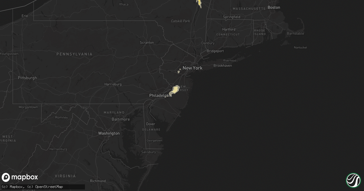
Hail Map in New Jersey on July 4, 2023
Get this storm
July 4 map
$229
one time, instant access
Download today. No call, no setup
Keep the $229
Bought the map and want the full workflow? Apply the entire $229 to a subscription within 7 days. None of it is wasted.
Every map, not just this one
This buys you this map. Subscription and you get every map we run, in the markets you choose from a few cities to whole states to nationwide. Plus real-time alerts the moment a storm fires.
Contact data
Name, contact info, occupancy, even credit band for addresses in the footprint. You go from where it hit to who to call.
Become the source they trust
Unlimited branding weather history reports on demand. You already have the documented answer ready for the property owner, and you are the one who showed up with it.
Property data and RoofTrace estimates
Pull up any address you have got, its value and the exact code rules for that jurisdiction, straight from One Click Code. Then RoofTrace estimates the squares, pitch, and roof value, priced the way you price.
Storm reports in New Jersey
New Jersey
| Date | Description |
|---|---|
| 07/04/20235:30 PM CDT | Tree down on highland ave. Time estimated by radar. |
| 07/04/20235:18 PM CDT | Tree down on cedar ave. Time estimated by radar. |
| 07/04/20235:14 PM CDT | Trees... Wires... And numerous large branches down; street flooding; navigation difficult. |
| 07/04/20235:12 PM CDT | Estimated 50 to 60 mph wind gusts on interstate 295 southbound by woodcrest station. Small branches flying onto the roadway. Time estimated from radar. |
| 07/04/20235:10 PM CDT | A downburst occurred around mt. Ephraim... Brooklawn... And westville... Nj on tuesday... July 4... 2023... Resulting in severe winds and downed trees across the area. |
| 07/04/20235:05 PM CDT | Tree across roadway. Time estimated by radar. |
| 07/04/20235:05 PM CDT | Estimated 60 mph wind gust. Time estimated from radar. |
| 07/04/20235:02 PM CDT | Power line down... Pole on house. Time estimated by radar. |
| 07/04/20235:00 PM CDT | Multiple trees down along kings hwy e and sylvan lake ave at haddonfield memorial high school and haddonfield baptist cemetery. Sylvan lake ave closed due to tree and p |
| 07/04/20235:00 PM CDT | A downburst occurred in the area of haddonfield... Nj on tuesday... July 4... 2023 resulting in widespread wind damage with numerous large trees uprooted or snapped at |
| 07/04/20235:00 PM CDT | Numerous downed trees... Poles... And power lines across the neighborhood between downtown haddonfield and mountwell park. |
| 07/04/20235:00 PM CDT | Multiple trees down on homes. Time estimated by radar. |
| 07/04/20235:00 PM CDT | Multiple roads closed due to downed trees... Power lines... And flooding. Time estimated by radar. |
| 07/04/20235:00 PM CDT | Tree and power lines down across centre street at ellis street. Road closed. Time estimated by radar. |
| 07/04/20234:50 PM CDT | Some trees down. Time estimated from radar. |
| 07/04/20234:50 PM CDT | Trees down at marlton parkway and sagemore drive. Time estimated from radar. |
| 07/04/20234:40 PM CDT | A series of downbursts occurred in the area of cherry hill... Evesham township... And marlton... Nj on tuesday... July 4... 2023 resulting in multiple downed trees acro |
| 07/04/20234:25 PM CDT | Trees down around indigo drive with damage to siding on homes. Time estimated by radar. |
| 07/04/20234:25 PM CDT | A downburst occurred in mount laurel... Nj on tuesday... July 4... 2023 resulting in multiple downed trees in the area surrounding union mill rd. Time estimated by rada |
| 07/04/20234:10 PM CDT | Tree down onto wires near union mill road. Time estimated from radar. |
| 07/04/20233:55 PM CDT | Tree down on landing street in lumberton. Time estimated from radar. |
| 07/04/20233:47 PM CDT | Hail estimated to be quarter size in westampton township in the deerwood area. Time estimated from radar. |
| 07/04/20233:20 PM CDT | Couple of trees down in the springfield township and jobstown areas. Time estimated from radar. |
| 07/04/20233:05 PM CDT | Tree onto power lines on west millstream road. Power outages reported. Time estimated from radar. |
| 07/04/20232:40 PM CDT | Poles and wires down in parts of upper freehold. Power outages. Time estimated from radar. |
| 07/04/20231:40 PM CDT | Picture shared on social media of a gas station canopy blown over on route 22 near rock avenue in north plainfield. Time estimated from radar. |
All States Impacted by Hail Map on July 4, 2023
Cities Impacted by Hail Map on July 4, 2023
- Scenic, SD
- Kyle, SD
- Interior, SD
- Pine Ridge, SD
- Caputa, SD
- Wall, SD
- New Underwood, SD
- Kadoka, SD
- Wasta, SD
- Owanka, SD
- Wanblee, SD
- Somerville, AL
- Union Grove, AL
- Arab, AL
- Hudson, WI
- River Falls, WI
- Roberts, WI
- Hastings, MN
- Cottage Grove, MN
- Saint Paul, MN
- Stillwater, MN
- Renville, MN
- Sacred Heart, MN
- Lake Andes, SD
- Wagner, SD
- Hurley, SD
- Bird Island, MN
- Honey Grove, TX
- Freeman, SD
- Viborg, SD
- Saint Paul Park, MN
- Inver Grove Heights, MN
- Mount Vernon, SD
- Mitchell, SD
- Buffalo Lake, MN
- Hector, MN
- Olivia, MN
- Danube, MN
- Utica, SD
- Lesterville, SD
- Avon, SD
- Irene, SD
- Tyndall, SD
- Sumner, TX
- Telephone, TX
- Scotland, SD
- Menno, SD
- Yankton, SD
- Tabor, SD
- Festus, MO
- Beldenville, WI
- Ellsworth, WI
- Afton, MN
- Colorado Springs, CO
- Peyton, CO
- Wheatland, WY
- Guernsey, WY
- Fort Laramie, WY
- Lingle, WY
- Yoder, WY
- Sanger, TX
- Calhan, CO
- Yoder, CO
- Humphrey, NE
- Lindsay, NE
- Genoa, NE
- Saint Edward, NE
- Platte Center, NE
- Monroe, NE
- Norfolk, NE
- Meadow Grove, NE
- Battle Creek, NE
- Pierce, NE
- Grinnell, KS
- Oakley, KS
- Columbus, NE
- Creston, NE
- Kensington, KS
- Agra, KS
- Cedar, KS
- Gaylord, KS
- Kirwin, KS
- Veteran, WY
- Torrington, WY
- Lyman, NE
- Gering, NE
- Morrill, NE
- Hoxie, KS
- Leoti, KS
- Manitou Springs, CO
- Cascade, CO
- Ordway, CO
- Manzanola, CO
- Sugar City, CO
- Rocky Ford, CO
- Olney Springs, CO
- Crowley, CO
- Selden, KS
- Morland, KS
- Campbell, NE
- Riverton, NE
- Inavale, NE
- Bladen, NE
- Sutton, NE
- Grafton, NE
- Henderson, NE
- Silver Creek, NE
- Duncan, NE
- Shelby, NE
- Osceola, NE
- Ponca, NE
- Dixon, NE
- Waterbury, NE
- Allen, NE
- Jackson, NE
- Sioux City, IA
- North Sioux City, SD
- Dakota City, NE
- South Sioux City, NE
- Lawton, IA
- Jefferson, SD
- Salix, IA
- Sergeant Bluff, IA
- Homer, NE
- Hubbard, NE
- Bronson, IA
- Emerson, NE
- Madison, NE
- Cherry Hill, NJ
- Ridgeville, SC
- Adams Run, SC
- Cottageville, SC
- Plattsburgh, NY
- West Chazy, NY
- Tunica, MS
- Fremont, MO
- Van Buren, MO
- Taylor, AR
- Hamilton, KS
- Mansfield, MO
- Irondale, MO
- Bismarck, MO
- Caledonia, MO
- Ironton, MO
- Brundidge, AL
- Banks, AL
- Sikes, LA
- Newcastle, NE
- Chester, IL
- Gillette, NJ
- Berkeley Heights, NJ
- Warren, NJ
- Watchung, NJ
- Alton, IA
- Hospers, IA
- Ellington, MO
- Leigh, NE
- Bunker Hill, IL
- Shipman, IL
- Osseo, WI
- Hixton, WI
- East Hardwick, VT
- Troy, AL
- Winona, KS
- Wrightstown, NJ
- Trenton, NJ
- Allentown, NJ
- Chesterfield, NJ
- Bellwood, NE
- La Junta, CO
- Saint Mary, MO
- Hartington, NE
- Jacksonville, FL
- Pemberton, NJ
- Benedict, NE
- Stromsburg, NE
- De Soto, MO
- Durant, MS
- Peru, NY
- Morgan, VT
- Usaf Academy, CO
- Alton, MO
- Model, CO
- Lamar, CO
- Water Valley, MS
- Batesville, MS
- Oxford, MS
- Columbus, NJ
- Jobstown, NJ
- Cream Ridge, NJ
- Stewart, MS
- Eupora, MS
- Wallace, KS
- Hinton, IA
- Doniphan, MO
- Fleming, GA
- Richmond Hill, GA
- Rouses Point, NY
- Yorktown, AR
- Gould, AR
- Star City, AR
- Sainte Genevieve, MO
- Perryville, MO
- Philipp, MS
- Doe Run, MO
- Park Hills, MO
- Elizabethtown, NY
- Warren, TX
- Tilden, NE
- Conway, MO
- Long Lane, MO
- Boone, CO
- Le Mars, IA
- Merrill, IA
- Mellwood, AR
- Taylor, MS
- Courtland, MS
- Stumpy Point, NC
- Newman Grove, NE
- Schuyler, NE
- Joint Base Mdl, NJ
- Robbinsville, NJ
- Forkland, AL
- West Helena, AR
- Greenback, TN
- Orlando, FL
- Hardeeville, SC
- Eminence, MO
- Salem, MO
- Sicily Island, LA
- Rising Star, TX
- Cisco, TX
- Carbon, TX
- Myrtle, MO
- Kountze, TX
- Charleston, MS
- Clarkson, NE
- Gatewood, MO
- Saint Johns, FL
- Orange City, IA
- Belvidere Center, VT
- Thomasville, AL
- Winona, MO
- Marion, IL
- Pittsburg, IL
- Summerville, SC
- Memphis, TN
- Germantown, TN
- Pueblo, CO
- Fouke, AR
- Winter, WI
- Clarksdale, MS
- Alligator, MS
- Alburgh, VT
- Champlain, NY
- Bolton, NC
- Crown Point, NY
- Ticonderoga, NY
- Tabor City, NC
- East Dublin, GA
- Wrightsville, GA
- Saint Augustine, FL
- Couch, MO
- Saint Cloud, FL
- Rentz, GA
- Morrisonville, NY
- Altona, NY
- Lake Waccamaw, NC
- Divide, CO
- Wakefield, NE
- Warm Springs, AR
- Boligee, AL
- Bound Brook, NJ
- Dunellen, NJ
- Martinsville, NJ
- Middlesex, NJ
- Mount Laurel, NJ
- Marlton, NJ
- Kingsley, IA
- Gilman, WI
- Mount Holly, NJ
- Bordentown, NJ
- Hainesport, NJ
- Vincentown, NJ
- Burlington, NJ
- Lumberton, NJ
- Medford, NJ
- Cookstown, NJ
- Hightstown, NJ
- New Egypt, NJ
- Glendora, MS
- Philadelphia, TN
- Loudon, TN
- Charleston, SC
- Goose Creek, SC
- Geneva, NE
- Glade, KS
- New London, MO
- Winter Park, FL
- Lyons, CO
- Fort Lupton, CO
- Longmont, CO
- Platteville, CO
- Mead, CO
- Johnstown, CO
- Milliken, CO
- Eureka, KS
- Hill City, KS
- Penokee, KS
- Lenora, KS
- Norton, KS
- Stockton, KS
- Phillipsburg, KS
- Tribune, KS
- Syracuse, KS
- Ayr, NE
- Blue Hill, NE
- Roseland, NE
- Fairfield, NE
- Glenvil, NE
- Lawrence, NE
- Clay Center, NE
- Deweese, NE
- Edgar, NE
- Nelson, NE
- Fairmont, NE
- McCool Junction, NE
- Shickley, NE
- Bruning, NE
- Strang, NE
- Carleton, NE
- Ong, NE
- Dwight, NE
- Valparaiso, NE
- Malmo, NE
- Bruno, NE
- Abie, NE
- Colon, NE
- Ulysses, NE
- Rising City, NE
- Linwood, NE
- Wahoo, NE
- Prague, NE
- Brainard, NE
- Weston, NE
- David City, NE
- Ceresco, NE
- Ithaca, NE
- Ashland, NE
- Waverly, NE
- Raymond, NE
- Memphis, NE
- Greenwood, NE
- Seward, NE
- Davey, NE
- Alvo, NE
- Elmwood, NE
- Eagle, NE
- Lincoln, NE
- Garland, NE
- Avoca, NE
- Bee, NE
- Weeping Water, NE
- Murdock, NE
- Palmyra, NE
- Pleasant Dale, NE
- Unadilla, NE
- Walton, NE
- Staplehurst, NE
- Bennet, NE
- Malcolm, NE
- Denton, NE
- Martell, NE
- Crete, NE
- Hickman, NE
- Adams, NE
- Roca, NE
- Milford, NE
- Surprise, NE
- Gresham, NE
- Waco, NE
- Utica, NE
- Goehner, NE
- Beaver Crossing, NE
- Kendall, KS
- Lakin, KS
- Coolidge, KS
- Oak, NE
- Davenport, NE
- Long Island, KS
- Almena, KS
- Prairie View, KS
- Deerfield, KS
- Holcomb, KS
- Granby, CO
- Parshall, CO
- Kremmling, CO
- Grand Lake, CO
- Hot Sulphur Springs, CO
- Rollinsville, CO
- Nederland, CO
- Tabernash, CO
- Winter Park, CO
- Ward, CO
- Fraser, CO
- Sprague, NE
- Hallam, NE
- Cook, NE
- Douglas, NE
- Firth, NE
- Syracuse, NE
- Burr, NE
- Panama, NE
- Sterling, NE
- Johnson, NE
- Tecumseh, NE
- Filley, NE
- Beatrice, NE
- Lewiston, NE
- Pickrell, NE
- Liberty, NE
- Clatonia, NE
- Cortland, NE
- Steinauer, NE
- Virginia, NE
- Elk Creek, NE
- Crab Orchard, NE
- Burchard, NE
- Jamestown, CO
- Central City, CO
- Boulder, CO
- Golden, CO
- Black Hawk, CO
- Eldorado Springs, CO
- Humboldt, NE
- Auburn, NE
- Table Rock, NE
- Pawnee City, NE
- Harvard, NE
- Saronville, NE
- Wilsey, KS
- Council Grove, KS
- Du Bois, NE
- Bern, KS
- Dawson, NE
- Salem, NE
- Baileyville, KS
- Seneca, KS
- Oneida, KS
- Sabetha, KS
- Buford, WY
- Tie Siding, WY
- Laramie, WY
- Cheyenne, WY
- Livermore, CO
- Red Feather Lakes, CO
- Granite Canon, WY
- Wellington, CO
- Laporte, CO
- Fort Collins, CO
- Verdon, NE
- Hiawatha, KS
- Morrill, KS
- Fairview, KS
- Powhattan, KS
- Horton, KS
- Soldier, KS
- Corning, KS
- Centralia, KS
- Vermillion, KS
- Frankfort, KS
- Wetmore, KS
- Circleville, KS
- Onaga, KS
- Netawaka, KS
- Axtell, KS
- Havensville, KS
- Goff, KS
- Westmoreland, KS
- Whiting, KS
- Oketo, KS
- Home, KS
- Summerfield, KS
- Wymore, NE
- Beattie, KS
- Blue Springs, NE
- Clay Center, KS
- Morganville, KS
- Green, KS
- Randolph, KS
- Leonardville, KS
- Riley, KS
- Manhattan, KS
- Milford, KS
- Wakefield, KS
- Junction City, KS
- Gypsum, KS
- Assaria, KS
- New Cambria, KS
- Lindsborg, KS
- Hope, KS
- Salina, KS
- Solomon, KS
- Abilene, KS
- Herington, KS
- Burdick, KS
- Woodbine, KS
- Enterprise, KS
- Chapman, KS
- Lost Springs, KS
- Ramona, KS
- White City, KS
- Tampa, KS
- Lincolnville, KS
- Durham, KS
- Everest, KS
- Robinson, KS
- Muscotah, KS
- Holton, KS
- Lancaster, KS
- Atchison, KS
- Effingham, KS
- Denton, KS
- Delia, KS
- Emmett, KS
- Hoyt, KS
- Saint Marys, KS
- Mayetta, KS
- Meriden, KS
- Valley Falls, KS
- Silver Lake, KS
- Nortonville, KS
- Topeka, KS
- Cummings, KS
- Denison, KS
- Rossville, KS
- Ozawkie, KS
- Maple Hill, KS
- Alma, KS
- Belvue, KS
- Wamego, KS
- Paxico, KS
- McFarland, KS
- Olsburg, KS
- Saint George, KS
- Auburn, KS
- Eskridge, KS
- Harveyville, KS
- Wakarusa, KS
- Carbondale, KS
- Burlingame, KS
- Tecumseh, KS
- Berryton, KS
- Grantville, KS
- Oskaloosa, KS
- Winchester, KS
- McLouth, KS
- Perry, KS
- Lecompton, KS
- Allen, KS
- Alta Vista, KS
- Dwight, KS
- Admire, KS
- Reading, KS
- Emporia, KS
- Americus, KS
- Strong City, KS
- Marion, KS
- Elmdale, KS
- Cottonwood Falls, KS
- Fairlee, VT
- Windsor, VT
- Franklin, NE
- Winnebago, NE
- Walthill, NE
- Macy, NE
- Upland, NE
- Sloan, IA
- Whiting, IA
- Tekamah, NE
- Craig, NE
- Stowe, VT
- Little Sioux, IA
- Blencoe, IA
- Onawa, IA
- Florissant, CO
- Minneapolis, KS
- Mason, TN
- Walden, CO
- Berthoud, CO
- Fort Edward, NY
- Argyle, NY
- Marienthal, KS
- Byhalia, MS
- Durand, WI
- Kinderhook, NY
- Stuyvesant, NY
- Selkirk, NY
- Castleton On Hudson, NY
- Valatie, NY
- Schodack Landing, NY
- Maynard, AR
- Pocahontas, AR
- Ravenden Springs, AR
- Rolla, MO
- Saint James, MO
- Bennington, KS
- Republican City, NE
- Schenectady, NY
- Ballston Lake, NY
- Amsterdam, NY
- Galway, NY
- Hernando, MS
- Clinton, NC
- Turkey, NC
- Monument, KS
- Mapleton, IA
- Glenmont, NY
- Ghent, NY
- Hudson, NY
- Ravena, NY
- Coeymans, NY
- Delmar, NY
- South Bethlehem, NY
- York, NE
- Punta Gorda, FL
- Maiden Rock, WI
- Bay City, WI
- Olive Branch, MS
- Colby, KS
- Athol, KS
- Morton, MS
- Pelahatchie, MS
- Brandon, MS
- Mendenhall, MS
- Greenwich, NY
- Schuylerville, NY
- Kingston, GA
- Taylorsville, GA
- Saint Pauls, NC
- Ellsworth, KS
- Clayton, LA
- Castana, IA
- Smithland, IA
- Rodney, IA
- Wasola, MO
- Exeter, NE
- Nelson, WI
- Mondovi, WI
- Stockholm, WI
- Plum City, WI
- Arkansaw, WI
- Holstein, NE
- Denton, TX
- Autryville, NC
- Stedman, NC
- Marion, SC
- Aynor, SC
- Nichols, SC
- Galivants Ferry, SC
- Mullins, SC
- Moville, IA
- Hornick, IA
- Rifle, CO
- Tipton, KS
- Longford, KS
- Duanesburg, NY
- Bloomington, NE
- Naponee, NE
- Hagaman, NY
- Portis, KS
- Pender, NE
- Bushton, KS
- Inland, NE
- Fredericktown, MO
- Potosi, MO
- Belgrade, MO
- Farmington, MO
- Parsons, TN
- Ireton, IA
- Rogers, NE
- Clarks, NE
- Morse Bluff, NE
- Walhalla, SC
- Thornfield, MO
- Squires, MO
- Drury, MO
- Norwood, MO
- Ava, MO
- Miltonvale, KS
- Osage City, KS
- Somerville, TN
- Oakland, TN
- Alton, KS
- Lake Placid, FL
- Bellvue, CO
- Rosalie, NE
- Bancroft, NE
- Pinson, AL
- Logan, KS
- Lyons, NE
- Barnes, KS
- Greenleaf, KS
- Luray, TN
- Huron, TN
- Henderson, TN
- Jacks Creek, TN
- Evergreen, CO
- Clifton, KS
- Palmer, KS
- Holly, CO
- Bogue, KS
- Cambridge, VT
- Smith Center, KS
- Woodbine, IA
- Logan, IA
- Elsberry, MO
- Osborne, KS
- Ballston Spa, NY
- Myakka City, FL
- Clayton, KS
- Jennings, KS
- Henning, TN
- Hillsboro, MO
- Warsaw, NC
- Decatur, NE
- Lonedell, MO
- Saint Clair, MO
- Batchtown, IL
- Hamburg, IL
- Mountain Grove, MO
- Bourbon, MO
- Fieldon, IL
- Hardin, IL
- Belvidere, NE
- Medon, TN
- Pinson, TN
- Fairbury, NE
- Dillon, SC
- Anthon, IA
- Toone, TN
- Hyde Park, VT
- Johnson, VT
- Waynesboro, TN
- Collinwood, TN
- Lake Cormorant, MS
- South Fulton, TN
- Remlap, AL
- Ladson, SC
- North Charleston, SC
- East Greenbush, NY
- Rensselaer, NY
- Concordia, KS
- Pine, CO
- Hendley, NE
- Fork, SC
- Stanton, TN
- Geneseo, KS
- Bolivar, TN
- Hildreth, NE
- Woodston, KS
- Slingerlands, NY
- Delphos, KS
- Cordova, NE
- Friend, NE
- Agency, MO
- Weston, MO
- Saint Joseph, MO
- Faucett, MO
- Bendena, KS
- Leavenworth, KS
- Highland, KS
- Wathena, KS
- Dearborn, MO
- Rushville, MO
- Troy, KS
- De Kalb, MO
- Easton, KS
- Camden Point, MO
- Liberty, MO
- Platte City, MO
- Kearney, MO
- Holt, MO
- Kansas City, MO
- Lathrop, MO
- Trimble, MO
- Farley, MO
- Fort Leavenworth, KS
- Edgerton, MO
- Gower, MO
- Lawson, MO
- Excelsior Springs, MO
- Plattsburg, MO
- Smithville, MO
- Lansing, KS
- Bonner Springs, KS
- Overland Park, KS
- Linwood, KS
- Prairie Village, KS
- Tonganoxie, KS
- Lenexa, KS
- Waldron, MO
- Kansas City, KS
- Riverside, MO
- De Soto, KS
- Basehor, KS
- Lawrence, KS
- Mission, KS
- Gardner, KS
- Shawnee, KS
- Olathe, KS
- Eudora, KS
- New Century, KS
- Lebo, KS
- Melvern, KS
- Le Roy, KS
- Garnett, KS
- Matfield Green, KS
- Olpe, KS
- Westphalia, KS
- Neosho Rapids, KS
- Welda, KS
- Gridley, KS
- Hartford, KS
- Madison, KS
- Waverly, KS
- Burlington, KS
- Morrisville, VT
- Cornish, NH
- Claremont, NH
- Lees Summit, MO
- Independence, MO
- Sibley, MO
- Oak Grove, MO
- Rayville, MO
- Leawood, KS
- Missouri City, MO
- Belton, MO
- Richmond, MO
- Bates City, MO
- Bucyrus, KS
- Napoleon, MO
- Camden, MO
- Blue Springs, MO
- Raymore, MO
- Stilwell, KS
- Greenwood, MO
- Grain Valley, MO
- Grandview, MO
- Orrick, MO
- Levasy, MO
- Lone Jack, MO
- Buckner, MO
- Iola, KS
- Kincaid, KS
- Neosho Falls, KS
- Colony, KS
- Yates Center, KS
- Piqua, KS
- La Harpe, KS
- Virgil, KS
- Humboldt, KS
- Toronto, KS
- Neal, KS
- Lyons, KS
- Chase, KS
- Lorraine, KS
- Inman, KS
- Little River, KS
- Linn, KS
- Sterling, KS
- Kanopolis, KS
- Cambridge, KS
- Latham, KS
- Denver, CO
- Pisgah, IA
- Littleton, CO
- Washington, KS
- Watkins, CO
- Aurora, CO
- Goddard, KS
- Garden Plain, KS
- Morrowville, KS
- Matheson, CO
- Limon, CO
- Hugo, CO
- Hutchinson, KS
- Buhler, KS
- Burrton, KS
- Cassoday, KS
- El Dorado, KS
- Burden, KS
- Karval, CO
- Marquette, KS
- Bentley, KS
- Maize, KS
- Colwich, KS
- Wichita, KS
- Kechi, KS
- Sedgwick, KS
- Valley Center, KS
- Newton, KS
- Greenwich, KS
- Mount Hope, KS
- Cedar Point, KS
- Bennett, CO
- Strasburg, CO
- Lehigh, KS
- Goessel, KS
- Hillsboro, KS
- Strum, WI
- Conifer, CO
- Brookville, KS
- Clark, CO
- Windom, KS
- Florence, KS
- Leon, KS
- Rosalia, KS
- Levant, KS
- Loveland, CO
- Fall River, KS
- Noble, MO
- Pollocksville, NC
- Deer Trail, CO
- Soldier, IA
- Halstead, KS
- Baldwin City, KS
- Estes Park, CO
- Atlanta, KS
- Kit Carson, CO
- Wild Horse, CO
- Loris, SC
- Turon, KS
- Stafford, KS
- Cunningham, KS
- Forestburg, TX
- Cheney, KS
- Wausau, WI
- Merrill, WI
- Antigo, WI
- Agate, CO
- Andale, KS
- Haven, KS
- Benton, KS
- Whitewater, KS
- Syracuse, MO
- Fortuna, MO
- Quenemo, KS
- Kingman, KS
- Pretty Prairie, KS
- Arlington, KS


