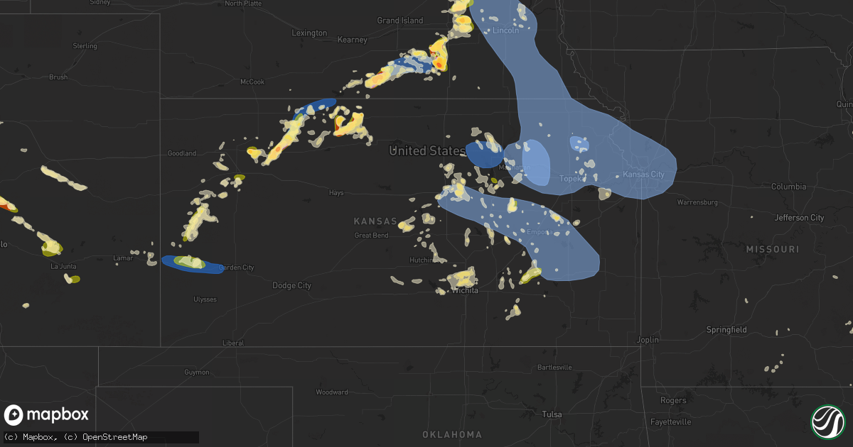
Hail Map in Kansas on July 4, 2023
Get this storm
July 4 map
$229
one time, instant access
Download today. No call, no setup
Keep the $229
Bought the map and want the full workflow? Apply the entire $229 to a subscription within 7 days. None of it is wasted.
Every map, not just this one
This buys you this map. Subscription and you get every map we run, in the markets you choose from a few cities to whole states to nationwide. Plus real-time alerts the moment a storm fires.
Contact data
Name, contact info, occupancy, even credit band for addresses in the footprint. You go from where it hit to who to call.
Become the source they trust
Unlimited branding weather history reports on demand. You already have the documented answer ready for the property owner, and you are the one who showed up with it.
Property data and RoofTrace estimates
Pull up any address you have got, its value and the exact code rules for that jurisdiction, straight from One Click Code. Then RoofTrace estimates the squares, pitch, and roof value, priced the way you price.
Storm reports in Kansas
Kansas
| Date | Description |
|---|---|
| 07/04/20236:59 PM CDT | Very heavy rain as well. |
| 07/04/20236:58 PM CDT | Quarter to half dollar size hail has been falling for approximately the last 15 minutes in phillipsburg. |
| 07/04/20236:56 PM CDT | Report from mping: half dollar |
| 07/04/20236:54 PM CDT | Delayed report of 60 mph winds with video. Time estimated from radar. |
| 07/04/20236:52 PM CDT | Mesonet recorded 58mph thunderstorm wind gust at 6:52pm. |
| 07/04/20236:52 PM CDT | Report from mping: quarter |
| 07/04/20236:50 PM CDT | Spotter reported quarter inch hail began at location at 6:40p ct... Increased to 1.25 inch hail at 6:44p ct... And still ongoing at time of report. |
| 07/04/20236:48 PM CDT | Spotter reports quarter to ping pong ball sized hail falling in phillipsburg. |
| 07/04/20236:45 PM CDT | Spotter reported estimated 60-70 mph wind gusts with storm at location. Trees bending with leaves blowing. No notable wind damage at the time. |
| 07/04/20236:30 PM CDT | Hail up to 1.25 inches reported at location. Time is radar estimated. |
| 07/04/20236:19 PM CDT | A local report indicates 71 MPH wind near 4 S Glade |
| 07/04/20236:10 PM CDT | 2 rounds of hail reported at location via social media with hail ranging up to quarter size. |
| 07/04/20236:00 PM CDT | Delayed facebook report of heavy quarter size hail. Time estimated from radar. |
| 07/04/20236:00 PM CDT | Report received via social media of estimated ping pong ball sized hail at location. Time is radar estimated. |
| 07/04/20235:30 PM CDT | Reported via social media. Golf ball to some bigger near egg/lime size. |
| 07/04/20235:30 PM CDT | A local report indicates 1.00 inch wind near 10 NNW Leoti |
| 07/04/20235:16 PM CDT | Time estimated via radar and ongoing for 5 minutes as of 4:22 pm mt. |
| 07/04/20235:00 PM CDT | Delayed social media report of hail ranging in size from peas to golf balls. |
| 07/04/20235:00 PM CDT | Ping pong ball sized hail falling in kensington. |
| 07/04/20234:45 PM CDT | Photo from facebook of golf ball size hail in kensington. |
| 07/04/20231:05 AM CDT | Co-op observer reported a tree had fallen on a house in la harpe. |
| 07/04/20231:02 AM CDT | Large tree fell onto car parked on street. |
| 07/04/202312:47 AM CDT | Report from mping: 1-inch tree limbs broken; time estimated via radar. |
| 07/04/202312:41 AM CDT | Report from mping: 1-inch tree limbs broken; timing estimated via radar. |
| 07/04/202312:22 AM CDT | Two 16 inch tree branches broken... One fell into an electrical line. |
| 07/04/202312:22 AM CDT | Measured via personal weather station. Time estimated via radar. |
| 07/04/202312:22 AM CDT | Several 1 to 2 inch tree limbs downed. Time estimated via radar. |
| 07/04/202312:10 AM CDT | 67 mph wind gust on personal weather station. |
| 07/04/202312:01 AM CDT | Corrects previous non-tstm wnd dmg report from baldwin city. Delayed report via social media of broken patio furniture and planters... A bent metal basketball pole and |
| 07/04/202312:00 AM CDT | Downed tree at 2nd and spruce in downtown leavenworth. Unknown tree size. Time estimated via radar. |
| 07/03/202311:55 PM CDT | Klwc asos. |
| 07/03/202311:52 PM CDT | A local report indicates 60 MPH wind near 1 ENE Lawrence |
| 07/03/202311:47 PM CDT | Corrects previous non-tstm wnd dmg report from mclouth. Delayed report via social media of a large tree limb about 8 inches in diameter down. Winds estimated between 60 |
| 07/03/202311:46 PM CDT | Personal weather station. |
| 07/03/202311:44 PM CDT | Personal weather station. |
| 07/03/202311:43 PM CDT | Estimated wind gust with visibility of 100 feet in the rain. |
| 07/03/202311:43 PM CDT | A local report indicates 58 MPH wind near 5 NNW Olpe |
| 07/03/202311:38 PM CDT | Estimate from em. |
| 07/03/202311:35 PM CDT | 72 mph gust measured on mesonet... On ks 99. |
| 07/03/202311:33 PM CDT | Quarter size hail per em. |
| 07/03/202311:26 PM CDT | A local report indicates 64 MPH wind near Elmdale |
| 07/03/202311:24 PM CDT | Personal weather station. |
| 07/03/202311:23 PM CDT | A local report indicates 58 MPH wind near 1 ENE Elmdale |
| 07/03/202311:18 PM CDT | Report from mping: 1-inch tree limbs broken; shingles blown off. |
| 07/03/202311:11 PM CDT | Corrects previous non-tstm wnd gst report from 4 n auburn. Delayed report via social media of estimated 75 to 80 mph wind gusts. |
| 07/03/202311:01 PM CDT | Personal weather station. |
| 07/03/202311:00 PM CDT | Pea size hail also fell. Delayed report. Time verified by radar. |
| 07/03/202310:47 PM CDT | A local report indicates 64 MPH wind near Galva |
| 07/03/202310:45 PM CDT | 86 mph wind measured on mobile mesonet along us 24. |
| 07/03/202310:45 PM CDT | 86 mph wind measured on mobile mesonet along us 24. |
| 07/03/202310:45 PM CDT | Corrects previous non-tstm wnd dmg report from 5 wnw mayetta. Delayed report of 6 inch tree limbs broken from healthy tree. Winds estimated at 75 to 80 mph. |
| 07/03/202310:34 PM CDT | Report from mping: quarter |
| 07/03/202310:32 PM CDT | A local report indicates 72 MPH wind near 2 SW Salina |
| 07/03/202310:32 PM CDT | Personal weather station. |
| 07/03/202310:25 PM CDT | 2 inch tree limbs down on w side of abilene. Time estimated from radar. |
| 07/03/202310:25 PM CDT | 2 inch limb down... Estimated 55 to 60 mph. |
| 07/03/202310:21 PM CDT | A local report indicates 73 MPH wind near Havensville |
| 07/03/202310:20 PM CDT | Corrects previous non-tstm wnd dmg report from 1 w manhattan. Picture via social media showing a large tree limb... Around a foot in diameter... Broken from a healthy t |
| 07/03/202310:18 PM CDT | Personal weather station. |
| 07/03/202310:10 PM CDT | A local report indicates 68 MPH wind near Frankfort |
| 07/03/202310:10 PM CDT | Trained spotter estimates 70 mph wind gust. |
| 07/03/20239:54 PM CDT | Kansas state mesonet reports gust to 62 mph. |
| 07/03/20239:43 PM CDT | Kansas state mesonet reported gust to 61 mph. |
| 07/03/20239:40 PM CDT | Unio and pacific station reported gusts to 65 mph. |
| 07/03/20239:25 PM CDT | Public weather station. |
| 07/03/20238:25 PM CDT | Social media report of an enclosed trailer flipped and a center pivot down. |
| 07/03/20238:19 PM CDT | Social media reports of power out and tree limbs down in the city of lakin. |
| 07/03/20238:00 PM CDT | A local report indicates 70 MPH wind near 5 N Almena |
| 07/03/20237:57 PM CDT | Mesonet reports wind gust of 68 mph at 7:57pm se of long island. |
| 07/03/20237:56 PM CDT | A local report indicates 70 MPH wind near 1 NNW Lakin |
| 07/03/20237:55 PM CDT | Corrects previous non-tstm wnd gst report from 5 wsw norton. Mesonet station nrrk1 norton 4sw. 10m wind speed measurement. |
| 07/03/20237:50 PM CDT | Kksnorto3 mesonet station reported 64 mph gust. |
| 07/03/20237:42 PM CDT | Corrects previous tstm wnd gst report from almena. Estimated 50-60 mph wind gusts at location reported causing rain to fall sideways briefly. Time is radar estimated. |
| 07/03/20237:42 PM CDT | Estimated 50-60 mph wind gusts at location reported causing rain to fall sideways briefly. |
| 07/03/20237:15 PM CDT | Estimated 60 mph strong wind gust at location with 1.5 inches of storm total rainfall so far. |
| 07/03/20237:13 PM CDT | Spotter reported wind blowing cabin roof blown off at location with an estimated 70+ mph wind gust. Power also lost at location. Time is radar estimated. |
| 07/03/20237:04 PM CDT | Estimated 60 mph wind gust reported at location. Spotter also reported that equipment needed to be tied down just in case it blew harder... But trees were bending a bit |
| 07/03/20237:00 PM CDT | Delayed report from mping: ping pong ball |
All States Impacted by Hail Map on July 4, 2023
Cities Impacted by Hail Map on July 4, 2023
- Scenic, SD
- Kyle, SD
- Interior, SD
- Pine Ridge, SD
- Caputa, SD
- Wall, SD
- New Underwood, SD
- Kadoka, SD
- Wasta, SD
- Owanka, SD
- Wanblee, SD
- Somerville, AL
- Union Grove, AL
- Arab, AL
- Hudson, WI
- River Falls, WI
- Roberts, WI
- Hastings, MN
- Cottage Grove, MN
- Saint Paul, MN
- Stillwater, MN
- Renville, MN
- Sacred Heart, MN
- Lake Andes, SD
- Wagner, SD
- Hurley, SD
- Bird Island, MN
- Honey Grove, TX
- Freeman, SD
- Viborg, SD
- Saint Paul Park, MN
- Inver Grove Heights, MN
- Mount Vernon, SD
- Mitchell, SD
- Buffalo Lake, MN
- Hector, MN
- Olivia, MN
- Danube, MN
- Utica, SD
- Lesterville, SD
- Avon, SD
- Irene, SD
- Tyndall, SD
- Sumner, TX
- Telephone, TX
- Scotland, SD
- Menno, SD
- Yankton, SD
- Tabor, SD
- Festus, MO
- Beldenville, WI
- Ellsworth, WI
- Afton, MN
- Colorado Springs, CO
- Peyton, CO
- Wheatland, WY
- Guernsey, WY
- Fort Laramie, WY
- Lingle, WY
- Yoder, WY
- Sanger, TX
- Calhan, CO
- Yoder, CO
- Humphrey, NE
- Lindsay, NE
- Genoa, NE
- Saint Edward, NE
- Platte Center, NE
- Monroe, NE
- Norfolk, NE
- Meadow Grove, NE
- Battle Creek, NE
- Pierce, NE
- Grinnell, KS
- Oakley, KS
- Columbus, NE
- Creston, NE
- Kensington, KS
- Agra, KS
- Cedar, KS
- Gaylord, KS
- Kirwin, KS
- Veteran, WY
- Torrington, WY
- Lyman, NE
- Gering, NE
- Morrill, NE
- Hoxie, KS
- Leoti, KS
- Manitou Springs, CO
- Cascade, CO
- Ordway, CO
- Manzanola, CO
- Sugar City, CO
- Rocky Ford, CO
- Olney Springs, CO
- Crowley, CO
- Selden, KS
- Morland, KS
- Campbell, NE
- Riverton, NE
- Inavale, NE
- Bladen, NE
- Sutton, NE
- Grafton, NE
- Henderson, NE
- Silver Creek, NE
- Duncan, NE
- Shelby, NE
- Osceola, NE
- Ponca, NE
- Dixon, NE
- Waterbury, NE
- Allen, NE
- Jackson, NE
- Sioux City, IA
- North Sioux City, SD
- Dakota City, NE
- South Sioux City, NE
- Lawton, IA
- Jefferson, SD
- Salix, IA
- Sergeant Bluff, IA
- Homer, NE
- Hubbard, NE
- Bronson, IA
- Emerson, NE
- Madison, NE
- Cherry Hill, NJ
- Ridgeville, SC
- Adams Run, SC
- Cottageville, SC
- Plattsburgh, NY
- West Chazy, NY
- Tunica, MS
- Fremont, MO
- Van Buren, MO
- Taylor, AR
- Hamilton, KS
- Mansfield, MO
- Irondale, MO
- Bismarck, MO
- Caledonia, MO
- Ironton, MO
- Brundidge, AL
- Banks, AL
- Sikes, LA
- Newcastle, NE
- Chester, IL
- Gillette, NJ
- Berkeley Heights, NJ
- Warren, NJ
- Watchung, NJ
- Alton, IA
- Hospers, IA
- Ellington, MO
- Leigh, NE
- Bunker Hill, IL
- Shipman, IL
- Osseo, WI
- Hixton, WI
- East Hardwick, VT
- Troy, AL
- Winona, KS
- Wrightstown, NJ
- Trenton, NJ
- Allentown, NJ
- Chesterfield, NJ
- Bellwood, NE
- La Junta, CO
- Saint Mary, MO
- Hartington, NE
- Jacksonville, FL
- Pemberton, NJ
- Benedict, NE
- Stromsburg, NE
- De Soto, MO
- Durant, MS
- Peru, NY
- Morgan, VT
- Usaf Academy, CO
- Alton, MO
- Model, CO
- Lamar, CO
- Water Valley, MS
- Batesville, MS
- Oxford, MS
- Columbus, NJ
- Jobstown, NJ
- Cream Ridge, NJ
- Stewart, MS
- Eupora, MS
- Wallace, KS
- Hinton, IA
- Doniphan, MO
- Fleming, GA
- Richmond Hill, GA
- Rouses Point, NY
- Yorktown, AR
- Gould, AR
- Star City, AR
- Sainte Genevieve, MO
- Perryville, MO
- Philipp, MS
- Doe Run, MO
- Park Hills, MO
- Elizabethtown, NY
- Warren, TX
- Tilden, NE
- Conway, MO
- Long Lane, MO
- Boone, CO
- Le Mars, IA
- Merrill, IA
- Mellwood, AR
- Taylor, MS
- Courtland, MS
- Stumpy Point, NC
- Newman Grove, NE
- Schuyler, NE
- Joint Base Mdl, NJ
- Robbinsville, NJ
- Forkland, AL
- West Helena, AR
- Greenback, TN
- Orlando, FL
- Hardeeville, SC
- Eminence, MO
- Salem, MO
- Sicily Island, LA
- Rising Star, TX
- Cisco, TX
- Carbon, TX
- Myrtle, MO
- Kountze, TX
- Charleston, MS
- Clarkson, NE
- Gatewood, MO
- Saint Johns, FL
- Orange City, IA
- Belvidere Center, VT
- Thomasville, AL
- Winona, MO
- Marion, IL
- Pittsburg, IL
- Summerville, SC
- Memphis, TN
- Germantown, TN
- Pueblo, CO
- Fouke, AR
- Winter, WI
- Clarksdale, MS
- Alligator, MS
- Alburgh, VT
- Champlain, NY
- Bolton, NC
- Crown Point, NY
- Ticonderoga, NY
- Tabor City, NC
- East Dublin, GA
- Wrightsville, GA
- Saint Augustine, FL
- Couch, MO
- Saint Cloud, FL
- Rentz, GA
- Morrisonville, NY
- Altona, NY
- Lake Waccamaw, NC
- Divide, CO
- Wakefield, NE
- Warm Springs, AR
- Boligee, AL
- Bound Brook, NJ
- Dunellen, NJ
- Martinsville, NJ
- Middlesex, NJ
- Mount Laurel, NJ
- Marlton, NJ
- Kingsley, IA
- Gilman, WI
- Mount Holly, NJ
- Bordentown, NJ
- Hainesport, NJ
- Vincentown, NJ
- Burlington, NJ
- Lumberton, NJ
- Medford, NJ
- Cookstown, NJ
- Hightstown, NJ
- New Egypt, NJ
- Glendora, MS
- Philadelphia, TN
- Loudon, TN
- Charleston, SC
- Goose Creek, SC
- Geneva, NE
- Glade, KS
- New London, MO
- Winter Park, FL
- Lyons, CO
- Fort Lupton, CO
- Longmont, CO
- Platteville, CO
- Mead, CO
- Johnstown, CO
- Milliken, CO
- Eureka, KS
- Hill City, KS
- Penokee, KS
- Lenora, KS
- Norton, KS
- Stockton, KS
- Phillipsburg, KS
- Tribune, KS
- Syracuse, KS
- Ayr, NE
- Blue Hill, NE
- Roseland, NE
- Fairfield, NE
- Glenvil, NE
- Lawrence, NE
- Clay Center, NE
- Deweese, NE
- Edgar, NE
- Nelson, NE
- Fairmont, NE
- McCool Junction, NE
- Shickley, NE
- Bruning, NE
- Strang, NE
- Carleton, NE
- Ong, NE
- Dwight, NE
- Valparaiso, NE
- Malmo, NE
- Bruno, NE
- Abie, NE
- Colon, NE
- Ulysses, NE
- Rising City, NE
- Linwood, NE
- Wahoo, NE
- Prague, NE
- Brainard, NE
- Weston, NE
- David City, NE
- Ceresco, NE
- Ithaca, NE
- Ashland, NE
- Waverly, NE
- Raymond, NE
- Memphis, NE
- Greenwood, NE
- Seward, NE
- Davey, NE
- Alvo, NE
- Elmwood, NE
- Eagle, NE
- Lincoln, NE
- Garland, NE
- Avoca, NE
- Bee, NE
- Weeping Water, NE
- Murdock, NE
- Palmyra, NE
- Pleasant Dale, NE
- Unadilla, NE
- Walton, NE
- Staplehurst, NE
- Bennet, NE
- Malcolm, NE
- Denton, NE
- Martell, NE
- Crete, NE
- Hickman, NE
- Adams, NE
- Roca, NE
- Milford, NE
- Surprise, NE
- Gresham, NE
- Waco, NE
- Utica, NE
- Goehner, NE
- Beaver Crossing, NE
- Kendall, KS
- Lakin, KS
- Coolidge, KS
- Oak, NE
- Davenport, NE
- Long Island, KS
- Almena, KS
- Prairie View, KS
- Deerfield, KS
- Holcomb, KS
- Granby, CO
- Parshall, CO
- Kremmling, CO
- Grand Lake, CO
- Hot Sulphur Springs, CO
- Rollinsville, CO
- Nederland, CO
- Tabernash, CO
- Winter Park, CO
- Ward, CO
- Fraser, CO
- Sprague, NE
- Hallam, NE
- Cook, NE
- Douglas, NE
- Firth, NE
- Syracuse, NE
- Burr, NE
- Panama, NE
- Sterling, NE
- Johnson, NE
- Tecumseh, NE
- Filley, NE
- Beatrice, NE
- Lewiston, NE
- Pickrell, NE
- Liberty, NE
- Clatonia, NE
- Cortland, NE
- Steinauer, NE
- Virginia, NE
- Elk Creek, NE
- Crab Orchard, NE
- Burchard, NE
- Jamestown, CO
- Central City, CO
- Boulder, CO
- Golden, CO
- Black Hawk, CO
- Eldorado Springs, CO
- Humboldt, NE
- Auburn, NE
- Table Rock, NE
- Pawnee City, NE
- Harvard, NE
- Saronville, NE
- Wilsey, KS
- Council Grove, KS
- Du Bois, NE
- Bern, KS
- Dawson, NE
- Salem, NE
- Baileyville, KS
- Seneca, KS
- Oneida, KS
- Sabetha, KS
- Buford, WY
- Tie Siding, WY
- Laramie, WY
- Cheyenne, WY
- Livermore, CO
- Red Feather Lakes, CO
- Granite Canon, WY
- Wellington, CO
- Laporte, CO
- Fort Collins, CO
- Verdon, NE
- Hiawatha, KS
- Morrill, KS
- Fairview, KS
- Powhattan, KS
- Horton, KS
- Soldier, KS
- Corning, KS
- Centralia, KS
- Vermillion, KS
- Frankfort, KS
- Wetmore, KS
- Circleville, KS
- Onaga, KS
- Netawaka, KS
- Axtell, KS
- Havensville, KS
- Goff, KS
- Westmoreland, KS
- Whiting, KS
- Oketo, KS
- Home, KS
- Summerfield, KS
- Wymore, NE
- Beattie, KS
- Blue Springs, NE
- Clay Center, KS
- Morganville, KS
- Green, KS
- Randolph, KS
- Leonardville, KS
- Riley, KS
- Manhattan, KS
- Milford, KS
- Wakefield, KS
- Junction City, KS
- Gypsum, KS
- Assaria, KS
- New Cambria, KS
- Lindsborg, KS
- Hope, KS
- Salina, KS
- Solomon, KS
- Abilene, KS
- Herington, KS
- Burdick, KS
- Woodbine, KS
- Enterprise, KS
- Chapman, KS
- Lost Springs, KS
- Ramona, KS
- White City, KS
- Tampa, KS
- Lincolnville, KS
- Durham, KS
- Everest, KS
- Robinson, KS
- Muscotah, KS
- Holton, KS
- Lancaster, KS
- Atchison, KS
- Effingham, KS
- Denton, KS
- Delia, KS
- Emmett, KS
- Hoyt, KS
- Saint Marys, KS
- Mayetta, KS
- Meriden, KS
- Valley Falls, KS
- Silver Lake, KS
- Nortonville, KS
- Topeka, KS
- Cummings, KS
- Denison, KS
- Rossville, KS
- Ozawkie, KS
- Maple Hill, KS
- Alma, KS
- Belvue, KS
- Wamego, KS
- Paxico, KS
- McFarland, KS
- Olsburg, KS
- Saint George, KS
- Auburn, KS
- Eskridge, KS
- Harveyville, KS
- Wakarusa, KS
- Carbondale, KS
- Burlingame, KS
- Tecumseh, KS
- Berryton, KS
- Grantville, KS
- Oskaloosa, KS
- Winchester, KS
- McLouth, KS
- Perry, KS
- Lecompton, KS
- Allen, KS
- Alta Vista, KS
- Dwight, KS
- Admire, KS
- Reading, KS
- Emporia, KS
- Americus, KS
- Strong City, KS
- Marion, KS
- Elmdale, KS
- Cottonwood Falls, KS
- Fairlee, VT
- Windsor, VT
- Franklin, NE
- Winnebago, NE
- Walthill, NE
- Macy, NE
- Upland, NE
- Sloan, IA
- Whiting, IA
- Tekamah, NE
- Craig, NE
- Stowe, VT
- Little Sioux, IA
- Blencoe, IA
- Onawa, IA
- Florissant, CO
- Minneapolis, KS
- Mason, TN
- Walden, CO
- Berthoud, CO
- Fort Edward, NY
- Argyle, NY
- Marienthal, KS
- Byhalia, MS
- Durand, WI
- Kinderhook, NY
- Stuyvesant, NY
- Selkirk, NY
- Castleton On Hudson, NY
- Valatie, NY
- Schodack Landing, NY
- Maynard, AR
- Pocahontas, AR
- Ravenden Springs, AR
- Rolla, MO
- Saint James, MO
- Bennington, KS
- Republican City, NE
- Schenectady, NY
- Ballston Lake, NY
- Amsterdam, NY
- Galway, NY
- Hernando, MS
- Clinton, NC
- Turkey, NC
- Monument, KS
- Mapleton, IA
- Glenmont, NY
- Ghent, NY
- Hudson, NY
- Ravena, NY
- Coeymans, NY
- Delmar, NY
- South Bethlehem, NY
- York, NE
- Punta Gorda, FL
- Maiden Rock, WI
- Bay City, WI
- Olive Branch, MS
- Colby, KS
- Athol, KS
- Morton, MS
- Pelahatchie, MS
- Brandon, MS
- Mendenhall, MS
- Greenwich, NY
- Schuylerville, NY
- Kingston, GA
- Taylorsville, GA
- Saint Pauls, NC
- Ellsworth, KS
- Clayton, LA
- Castana, IA
- Smithland, IA
- Rodney, IA
- Wasola, MO
- Exeter, NE
- Nelson, WI
- Mondovi, WI
- Stockholm, WI
- Plum City, WI
- Arkansaw, WI
- Holstein, NE
- Denton, TX
- Autryville, NC
- Stedman, NC
- Marion, SC
- Aynor, SC
- Nichols, SC
- Galivants Ferry, SC
- Mullins, SC
- Moville, IA
- Hornick, IA
- Rifle, CO
- Tipton, KS
- Longford, KS
- Duanesburg, NY
- Bloomington, NE
- Naponee, NE
- Hagaman, NY
- Portis, KS
- Pender, NE
- Bushton, KS
- Inland, NE
- Fredericktown, MO
- Potosi, MO
- Belgrade, MO
- Farmington, MO
- Parsons, TN
- Ireton, IA
- Rogers, NE
- Clarks, NE
- Morse Bluff, NE
- Walhalla, SC
- Thornfield, MO
- Squires, MO
- Drury, MO
- Norwood, MO
- Ava, MO
- Miltonvale, KS
- Osage City, KS
- Somerville, TN
- Oakland, TN
- Alton, KS
- Lake Placid, FL
- Bellvue, CO
- Rosalie, NE
- Bancroft, NE
- Pinson, AL
- Logan, KS
- Lyons, NE
- Barnes, KS
- Greenleaf, KS
- Luray, TN
- Huron, TN
- Henderson, TN
- Jacks Creek, TN
- Evergreen, CO
- Clifton, KS
- Palmer, KS
- Holly, CO
- Bogue, KS
- Cambridge, VT
- Smith Center, KS
- Woodbine, IA
- Logan, IA
- Elsberry, MO
- Osborne, KS
- Ballston Spa, NY
- Myakka City, FL
- Clayton, KS
- Jennings, KS
- Henning, TN
- Hillsboro, MO
- Warsaw, NC
- Decatur, NE
- Lonedell, MO
- Saint Clair, MO
- Batchtown, IL
- Hamburg, IL
- Mountain Grove, MO
- Bourbon, MO
- Fieldon, IL
- Hardin, IL
- Belvidere, NE
- Medon, TN
- Pinson, TN
- Fairbury, NE
- Dillon, SC
- Anthon, IA
- Toone, TN
- Hyde Park, VT
- Johnson, VT
- Waynesboro, TN
- Collinwood, TN
- Lake Cormorant, MS
- South Fulton, TN
- Remlap, AL
- Ladson, SC
- North Charleston, SC
- East Greenbush, NY
- Rensselaer, NY
- Concordia, KS
- Pine, CO
- Hendley, NE
- Fork, SC
- Stanton, TN
- Geneseo, KS
- Bolivar, TN
- Hildreth, NE
- Woodston, KS
- Slingerlands, NY
- Delphos, KS
- Cordova, NE
- Friend, NE
- Agency, MO
- Weston, MO
- Saint Joseph, MO
- Faucett, MO
- Bendena, KS
- Leavenworth, KS
- Highland, KS
- Wathena, KS
- Dearborn, MO
- Rushville, MO
- Troy, KS
- De Kalb, MO
- Easton, KS
- Camden Point, MO
- Liberty, MO
- Platte City, MO
- Kearney, MO
- Holt, MO
- Kansas City, MO
- Lathrop, MO
- Trimble, MO
- Farley, MO
- Fort Leavenworth, KS
- Edgerton, MO
- Gower, MO
- Lawson, MO
- Excelsior Springs, MO
- Plattsburg, MO
- Smithville, MO
- Lansing, KS
- Bonner Springs, KS
- Overland Park, KS
- Linwood, KS
- Prairie Village, KS
- Tonganoxie, KS
- Lenexa, KS
- Waldron, MO
- Kansas City, KS
- Riverside, MO
- De Soto, KS
- Basehor, KS
- Lawrence, KS
- Mission, KS
- Gardner, KS
- Shawnee, KS
- Olathe, KS
- Eudora, KS
- New Century, KS
- Lebo, KS
- Melvern, KS
- Le Roy, KS
- Garnett, KS
- Matfield Green, KS
- Olpe, KS
- Westphalia, KS
- Neosho Rapids, KS
- Welda, KS
- Gridley, KS
- Hartford, KS
- Madison, KS
- Waverly, KS
- Burlington, KS
- Morrisville, VT
- Cornish, NH
- Claremont, NH
- Lees Summit, MO
- Independence, MO
- Sibley, MO
- Oak Grove, MO
- Rayville, MO
- Leawood, KS
- Missouri City, MO
- Belton, MO
- Richmond, MO
- Bates City, MO
- Bucyrus, KS
- Napoleon, MO
- Camden, MO
- Blue Springs, MO
- Raymore, MO
- Stilwell, KS
- Greenwood, MO
- Grain Valley, MO
- Grandview, MO
- Orrick, MO
- Levasy, MO
- Lone Jack, MO
- Buckner, MO
- Iola, KS
- Kincaid, KS
- Neosho Falls, KS
- Colony, KS
- Yates Center, KS
- Piqua, KS
- La Harpe, KS
- Virgil, KS
- Humboldt, KS
- Toronto, KS
- Neal, KS
- Lyons, KS
- Chase, KS
- Lorraine, KS
- Inman, KS
- Little River, KS
- Linn, KS
- Sterling, KS
- Kanopolis, KS
- Cambridge, KS
- Latham, KS
- Denver, CO
- Pisgah, IA
- Littleton, CO
- Washington, KS
- Watkins, CO
- Aurora, CO
- Goddard, KS
- Garden Plain, KS
- Morrowville, KS
- Matheson, CO
- Limon, CO
- Hugo, CO
- Hutchinson, KS
- Buhler, KS
- Burrton, KS
- Cassoday, KS
- El Dorado, KS
- Burden, KS
- Karval, CO
- Marquette, KS
- Bentley, KS
- Maize, KS
- Colwich, KS
- Wichita, KS
- Kechi, KS
- Sedgwick, KS
- Valley Center, KS
- Newton, KS
- Greenwich, KS
- Mount Hope, KS
- Cedar Point, KS
- Bennett, CO
- Strasburg, CO
- Lehigh, KS
- Goessel, KS
- Hillsboro, KS
- Strum, WI
- Conifer, CO
- Brookville, KS
- Clark, CO
- Windom, KS
- Florence, KS
- Leon, KS
- Rosalia, KS
- Levant, KS
- Loveland, CO
- Fall River, KS
- Noble, MO
- Pollocksville, NC
- Deer Trail, CO
- Soldier, IA
- Halstead, KS
- Baldwin City, KS
- Estes Park, CO
- Atlanta, KS
- Kit Carson, CO
- Wild Horse, CO
- Loris, SC
- Turon, KS
- Stafford, KS
- Cunningham, KS
- Forestburg, TX
- Cheney, KS
- Wausau, WI
- Merrill, WI
- Antigo, WI
- Agate, CO
- Andale, KS
- Haven, KS
- Benton, KS
- Whitewater, KS
- Syracuse, MO
- Fortuna, MO
- Quenemo, KS
- Kingman, KS
- Pretty Prairie, KS
- Arlington, KS


