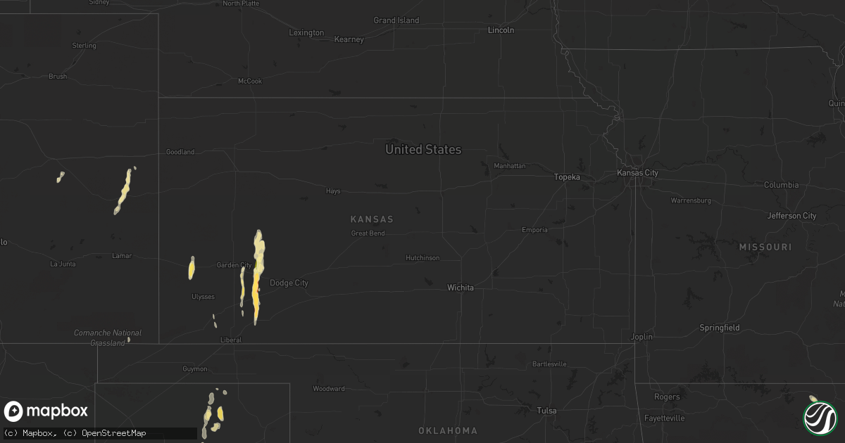
Hail Map in Kansas on July 3, 2015
Get this storm
July 3 map
$229
one time, instant access
Download today. No call, no setup
Keep the $229
Bought the map and want the full workflow? Apply the entire $229 to a subscription within 7 days. None of it is wasted.
Every map, not just this one
This buys you this map. Subscription and you get every map we run, in the markets you choose from a few cities to whole states to nationwide. Plus real-time alerts the moment a storm fires.
Contact data
Name, contact info, occupancy, even credit band for addresses in the footprint. You go from where it hit to who to call.
Become the source they trust
Unlimited branding weather history reports on demand. You already have the documented answer ready for the property owner, and you are the one who showed up with it.
Property data and RoofTrace estimates
Pull up any address you have got, its value and the exact code rules for that jurisdiction, straight from One Click Code. Then RoofTrace estimates the squares, pitch, and roof value, priced the way you price.
Storm reports in Kansas
Kansas
| Date | Description |
|---|---|
| 07/03/20156:40 PM CDT | Powerlines were reported down at the intersection of road j and road 10 |
| 07/03/20156:36 PM CDT | The hailstones were reported to be soft. |
| 07/03/20156:33 PM CDT | Numerous large branches were blown down in copeland. |
| 07/03/20156:33 PM CDT | The metal roof was blown from a building... And a tree three feet in diameter was blown down. |
| 07/03/20156:32 PM CDT | A local report indicates 58 MPH wind near COPELAND |
| 07/03/20156:27 PM CDT | Center pivot overturned at y and 5 road |
| 07/03/20156:25 PM CDT | Wind estimated at 80 to 100 mph. |
| 07/03/20156:25 PM CDT | Numerous large limbs were blown from trees around a residence. |
| 07/03/20156:25 PM CDT | Part of the roof was blown from a residence. |
| 07/03/20156:18 PM CDT | Power lines down and power poles snapped |
| 07/03/20156:15 PM CDT | Six center pivot spriklers were overturned in this vicinity from 6 road to 9 road along t road |
| 07/03/20156:14 PM CDT | A local report indicates 2.00 inch wind near 9 SW INGALLS |
| 07/03/20156:14 PM CDT | A local report indicates 60 MPH wind near 9 SW INGALLS |
| 07/03/20156:12 PM CDT | Power lines down at 8 and n road |
| 07/03/20156:00 PM CDT | Large tree branches were down and automobile windows broken out at the charleston rest area. |
| 07/03/20155:50 PM CDT | Powerlines were reported down at the intersection of road j and road 10 |
| 07/03/20155:33 PM CDT | A local report indicates 1.25 inch wind near 1 WSW KENDALL |
| 07/03/20155:28 PM CDT | A local report indicates 60 MPH wind near 11 WNW KALVESTA |
All States Impacted by Hail Map on July 3, 2015
Cities Impacted by Hail Map on July 3, 2015
- Kit Carson, CO
- Colorado Springs, CO
- Cascade, CO
- Pie Town, NM
- Arcadia, FL
- Zolfo Springs, FL
- Macon, MS
- Louisville, MS
- Garden City, KS
- Pierceville, KS
- Cimarron, KS
- Eudora, AR
- Laramie, WY
- Spearman, TX
- Hardesty, OK
- Eutaw, AL
- Thermopolis, WY
- Worland, WY
- Grandfield, OK
- Westwood, CA
- Chester, CA
- Immokalee, FL
- Hugo, CO
- Ingalls, KS
- Cleveland, NM
- Mora, NM
- Hooker, OK
- West Blocton, AL
- Mercer, WI
- Meeteetse, WY
- Fort Myers, FL
- Stinnett, TX
- Mcalester, OK
- Savanna, OK
- Kaycee, WY
- Midwest, WY
- Casper, WY
- Cimarron, NM
- Cheyenne, WY
- Hurley, WI
- Garrett, WY
- Waurika, OK
- Bosler, WY
- Wheatland, WY
- Clermont, FL
- Lakin, KS
- Kendall, KS
- Labelle, FL
- Sublette, KS
- Oak Grove, LA
- Punta Gorda, FL
- Winter Garden, FL
- Los Lunas, NM
- Lawley, AL
- Brierfield, AL
- Brent, AL
- Thorsby, AL
- Randolph, AL
- Jemison, AL
- Centreville, AL
- Duncanville, AL
- Maplesville, AL
- Wauchula, FL
- Davisboro, GA
- Bartow, GA
- Moscow, KS
- Tampa, FL
- Stratton, CO
- Buffalo, WY
- Boligee, AL
- Newton, AL
- Dothan, AL
- Tyler, AL
- Pine Apple, AL
- Hayneville, AL
- Minter, AL
- Hobart, OK
- Roosevelt, OK
- Indianola, MS
- Leland, MS
- Vici, OK
- Leedey, OK
- Weleetka, OK
- Lovington, NM
- Salem, AR
- Fargo, OK
- Elbert, CO
- Lagrange, GA
- Montezuma, KS
- Hogansville, GA
- Ringling, OK
- Ryan, OK
- Livermore, CO
- Granite Canon, WY
- Wellington, CO
- Brooksville, KY
- Mount Olivet, KY
- Cynthiana, KY
- Crossett, AR
- Hamburg, AR
- Wetumpka, AL
- Tallassee, AL
- Eclectic, AL
- Stanton, AL
- Green Mountain Falls, CO
- Stuart, OK
- Oklaunion, TX
- Vernon, TX
- Eagletown, OK
- Perryton, TX
- Miami, TX
- Noxapater, MS
- Woodland Park, CO
- Roswell, NM
- Coila, MS
- Sidon, MS
- Greenwood, MS
- Bethune, CO
- Cheyenne Wells, CO
- Copeland, KS
- Lowndesboro, AL
- Livingston, TX
- Onalaska, TX
- Yazoo City, MS
- Plains, KS
- Winter Haven, FL
- Auburndale, FL
- Butler, OK
- Naples, FL
- Wilmot, AR
- Shaw, MS
- Lakeland, FL
- Kingsland, AR
- Louisville, GA
- Bentonia, MS
- Broken Bow, OK
- Buford, WY
- Aliceville, AL
- Crowell, TX
- Midland City, AL
- Dighton, KS
- Lake Alfred, FL
- Polk City, FL
- Rockford, AL
- Burlington, CO
- Bonita Springs, FL
- Mountain Park, OK
- Spooner, WI
- Sallisaw, OK
- Equality, AL
- Guymon, OK
- Peyton, CO
- New Edinburg, AR
- Charleston, MS
- Tutwiler, MS
- Sarasota, FL
- Vincent, AL
- Cropwell, AL
- Springfield, AR
- Hope, AR
- Dunnellon, FL
- Warren, AR
- Burgaw, NC
- Parrish, FL
- Hattieville, AR
- Dermott, AR
- North Fort Myers, FL
- Saint George, UT
- Coy, AL
- Ackerman, MS
- Thomaston, AL
- Catherine, AL
- Susanville, CA
- Indianola, OK
- Duncan, MS
- Clarksdale, MS
- Glenrock, WY
- Gordon, WI
- Snow Lake, AR
- Billingsley, AL
- Prattville, AL
- New Blaine, AR
- Verbena, AL
- Marbury, AL
- Solon Springs, WI
- Hanna, OK
- Dustin, OK
- Lexington, OK
- Campo, CO
- Mena, AR
- Sylacauga, AL
- Epes, AL
- Havana, AR
- Belleville, AR
- Coalgate, OK
- Knoxville, AL
- Deatsville, AL
- Alpine, AL
- Byars, OK
- Wetumka, OK
- Saint Cloud, FL
- Muldrow, OK
- Eatonton, GA
- Lower Peach Tree, AL
- Alligator, MS
- Montverde, FL
- Rolling Fork, MS
- Greensboro, AL
- Montevallo, AL
- Marion, AL
- Clanton, AL
- West Point, GA
- Weogufka, AL
- Marion Junction, AL
- Orrville, AL
- Davidson, OK
- Hugoton, KS
- Arnett, OK
- Banks, AR
- Lake Village, AR
- Shell Lake, WI
- Tatum, NM
- Brooksville, FL
- Mulberry, FL
- Gainesville, AL
- Ganado, AZ
- Groveland, FL
- Slocomb, AL
- Headland, AL
- Gardner, CO
- Tecumseh, OK
- Holman, NM
- Waverly, AL
- Maud, OK
- Konawa, OK
- Trego, WI
- Vero Beach, FL
- Oak Ridge, LA
- Chadbourn, NC
- Borger, TX
- Bena, MN
- Pell City, AL
- Ellaville, GA
- Buena Vista, GA
- Okeechobee, FL
- Eads, CO
- Gunnison, MS
- Talladega, AL
- Morriston, FL
- Lamar, OK
- Lanett, AL
- Oakland, FL


