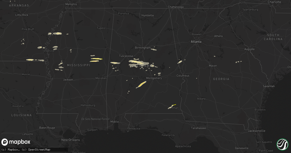
Hail Map in Alabama on July 3, 2015
Get this storm
July 3 map
$229
one time, instant access
Download today. No call, no setup
Keep the $229
Bought the map and want the full workflow? Apply the entire $229 to a subscription within 7 days. None of it is wasted.
Every map, not just this one
This buys you this map. Subscription and you get every map we run, in the markets you choose from a few cities to whole states to nationwide. Plus real-time alerts the moment a storm fires.
Contact data
Name, contact info, occupancy, even credit band for addresses in the footprint. You go from where it hit to who to call.
Become the source they trust
Unlimited branding weather history reports on demand. You already have the documented answer ready for the property owner, and you are the one who showed up with it.
Property data and RoofTrace estimates
Pull up any address you have got, its value and the exact code rules for that jurisdiction, straight from One Click Code. Then RoofTrace estimates the squares, pitch, and roof value, priced the way you price.
Storm reports in Alabama
Alabama
| Date | Description |
|---|---|
| 07/03/20155:40 PM CDT | Numerous calls and reports from the jemison area of 1 inch hail...mixed with larger stones |
| 07/03/20154:43 PM CDT | Large hail reported in and around centreville with some damage. Trees also reported down near brent. |
| 07/03/201512:05 AM CDT | Trees down in two separate locations near the eagle creek community. |
| 07/02/20159:32 PM CDT | Several trees down. Also a home weather station recorded a 57 mph wind gust in north phenix city. |
| 07/02/20159:30 PM CDT | Trees down in numerous locations across chambers county including lafayette...lanett...and valley. |
| 07/02/20157:22 PM CDT | Reported near wallace college. |
| 07/02/20157:20 PM CDT | Tree blown down in the pinckard area. |
| 07/02/20157:07 PM CDT | Several trees and powerlines down. Also reports of pea to marble size hail. |
| 07/02/20157:07 PM CDT | Large tree uprooted and fell into judge logue road blocking the roadway. Tweeted photo by dothan fire dept. |
All States Impacted by Hail Map on July 3, 2015
Cities Impacted by Hail Map on July 3, 2015
- Kit Carson, CO
- Colorado Springs, CO
- Cascade, CO
- Pie Town, NM
- Arcadia, FL
- Zolfo Springs, FL
- Macon, MS
- Louisville, MS
- Garden City, KS
- Pierceville, KS
- Cimarron, KS
- Eudora, AR
- Laramie, WY
- Spearman, TX
- Hardesty, OK
- Eutaw, AL
- Thermopolis, WY
- Worland, WY
- Grandfield, OK
- Westwood, CA
- Chester, CA
- Immokalee, FL
- Hugo, CO
- Ingalls, KS
- Cleveland, NM
- Mora, NM
- Hooker, OK
- West Blocton, AL
- Mercer, WI
- Meeteetse, WY
- Fort Myers, FL
- Stinnett, TX
- Mcalester, OK
- Savanna, OK
- Kaycee, WY
- Midwest, WY
- Casper, WY
- Cimarron, NM
- Cheyenne, WY
- Hurley, WI
- Garrett, WY
- Waurika, OK
- Bosler, WY
- Wheatland, WY
- Clermont, FL
- Lakin, KS
- Kendall, KS
- Labelle, FL
- Sublette, KS
- Oak Grove, LA
- Punta Gorda, FL
- Winter Garden, FL
- Los Lunas, NM
- Lawley, AL
- Brierfield, AL
- Brent, AL
- Thorsby, AL
- Randolph, AL
- Jemison, AL
- Centreville, AL
- Duncanville, AL
- Maplesville, AL
- Wauchula, FL
- Davisboro, GA
- Bartow, GA
- Moscow, KS
- Tampa, FL
- Stratton, CO
- Buffalo, WY
- Boligee, AL
- Newton, AL
- Dothan, AL
- Tyler, AL
- Pine Apple, AL
- Hayneville, AL
- Minter, AL
- Hobart, OK
- Roosevelt, OK
- Indianola, MS
- Leland, MS
- Vici, OK
- Leedey, OK
- Weleetka, OK
- Lovington, NM
- Salem, AR
- Fargo, OK
- Elbert, CO
- Lagrange, GA
- Montezuma, KS
- Hogansville, GA
- Ringling, OK
- Ryan, OK
- Livermore, CO
- Granite Canon, WY
- Wellington, CO
- Brooksville, KY
- Mount Olivet, KY
- Cynthiana, KY
- Crossett, AR
- Hamburg, AR
- Wetumpka, AL
- Tallassee, AL
- Eclectic, AL
- Stanton, AL
- Green Mountain Falls, CO
- Stuart, OK
- Oklaunion, TX
- Vernon, TX
- Eagletown, OK
- Perryton, TX
- Miami, TX
- Noxapater, MS
- Woodland Park, CO
- Roswell, NM
- Coila, MS
- Sidon, MS
- Greenwood, MS
- Bethune, CO
- Cheyenne Wells, CO
- Copeland, KS
- Lowndesboro, AL
- Livingston, TX
- Onalaska, TX
- Yazoo City, MS
- Plains, KS
- Winter Haven, FL
- Auburndale, FL
- Butler, OK
- Naples, FL
- Wilmot, AR
- Shaw, MS
- Lakeland, FL
- Kingsland, AR
- Louisville, GA
- Bentonia, MS
- Broken Bow, OK
- Buford, WY
- Aliceville, AL
- Crowell, TX
- Midland City, AL
- Dighton, KS
- Lake Alfred, FL
- Polk City, FL
- Rockford, AL
- Burlington, CO
- Bonita Springs, FL
- Mountain Park, OK
- Spooner, WI
- Sallisaw, OK
- Equality, AL
- Guymon, OK
- Peyton, CO
- New Edinburg, AR
- Charleston, MS
- Tutwiler, MS
- Sarasota, FL
- Vincent, AL
- Cropwell, AL
- Springfield, AR
- Hope, AR
- Dunnellon, FL
- Warren, AR
- Burgaw, NC
- Parrish, FL
- Hattieville, AR
- Dermott, AR
- North Fort Myers, FL
- Saint George, UT
- Coy, AL
- Ackerman, MS
- Thomaston, AL
- Catherine, AL
- Susanville, CA
- Indianola, OK
- Duncan, MS
- Clarksdale, MS
- Glenrock, WY
- Gordon, WI
- Snow Lake, AR
- Billingsley, AL
- Prattville, AL
- New Blaine, AR
- Verbena, AL
- Marbury, AL
- Solon Springs, WI
- Hanna, OK
- Dustin, OK
- Lexington, OK
- Campo, CO
- Mena, AR
- Sylacauga, AL
- Epes, AL
- Havana, AR
- Belleville, AR
- Coalgate, OK
- Knoxville, AL
- Deatsville, AL
- Alpine, AL
- Byars, OK
- Wetumka, OK
- Saint Cloud, FL
- Muldrow, OK
- Eatonton, GA
- Lower Peach Tree, AL
- Alligator, MS
- Montverde, FL
- Rolling Fork, MS
- Greensboro, AL
- Montevallo, AL
- Marion, AL
- Clanton, AL
- West Point, GA
- Weogufka, AL
- Marion Junction, AL
- Orrville, AL
- Davidson, OK
- Hugoton, KS
- Arnett, OK
- Banks, AR
- Lake Village, AR
- Shell Lake, WI
- Tatum, NM
- Brooksville, FL
- Mulberry, FL
- Gainesville, AL
- Ganado, AZ
- Groveland, FL
- Slocomb, AL
- Headland, AL
- Gardner, CO
- Tecumseh, OK
- Holman, NM
- Waverly, AL
- Maud, OK
- Konawa, OK
- Trego, WI
- Vero Beach, FL
- Oak Ridge, LA
- Chadbourn, NC
- Borger, TX
- Bena, MN
- Pell City, AL
- Ellaville, GA
- Buena Vista, GA
- Okeechobee, FL
- Eads, CO
- Gunnison, MS
- Talladega, AL
- Morriston, FL
- Lamar, OK
- Lanett, AL
- Oakland, FL


