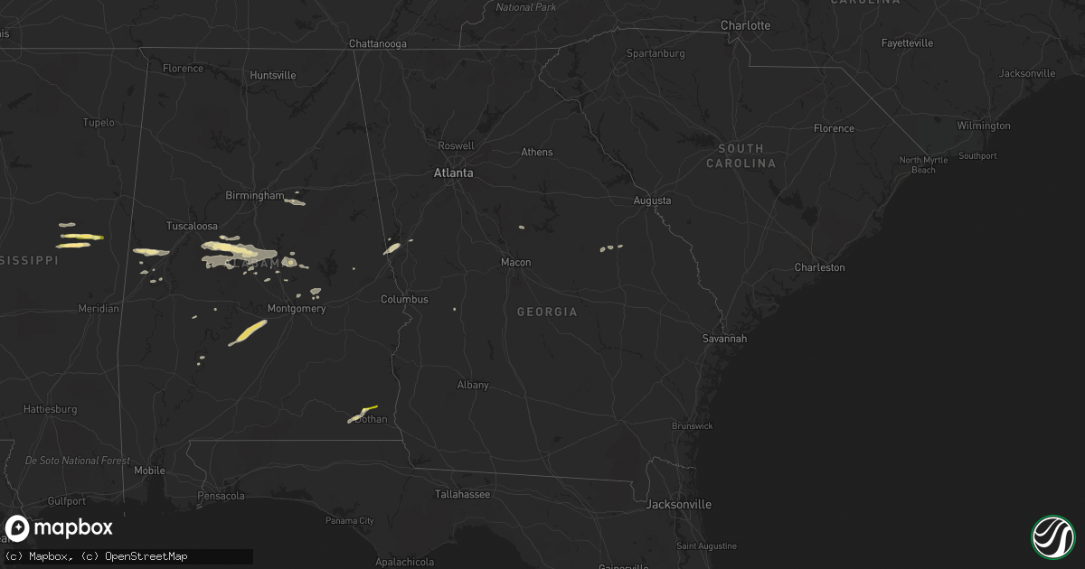
Hail Map in Georgia on July 3, 2015
Get this storm
July 3 map
$229
one time, instant access
Download today. No call, no setup
Keep the $229
Bought the map and want the full workflow? Apply the entire $229 to a subscription within 7 days. None of it is wasted.
Every map, not just this one
This buys you this map. Subscription and you get every map we run, in the markets you choose from a few cities to whole states to nationwide. Plus real-time alerts the moment a storm fires.
Contact data
Name, contact info, occupancy, even credit band for addresses in the footprint. You go from where it hit to who to call.
Become the source they trust
Unlimited branding weather history reports on demand. You already have the documented answer ready for the property owner, and you are the one who showed up with it.
Property data and RoofTrace estimates
Pull up any address you have got, its value and the exact code rules for that jurisdiction, straight from One Click Code. Then RoofTrace estimates the squares, pitch, and roof value, priced the way you price.
Storm reports in Georgia
Georgia
| Date | Description |
|---|---|
| 07/03/201512:35 PM CDT | Power lines were blown down onto curtis and east ogeechee streets. |
| 07/03/201512:14 PM CDT | Large tree limbs were blown down on a private lot near grimm avenue. |
| 07/03/201512:06 PM CDT | Burke ema reported tree down on hwy 56 at mile marker 15...which is 15 miles sw of waynesboro. Time estimated. |
| 07/03/201512:05 PM CDT | Burke ema reported tree down on herndon rd at mccollough church rd. Time estimated. |
| 07/03/201512:00 PM CDT | Burke ema reported tree down on hills mill pond rd. Time estimated. |
| 07/03/201511:05 AM CDT | Tree down at wrightsboro road and baker place road. Time estimated by radar. |
| 07/03/201510:52 AM CDT | 911 center reports several trees and powerlines down between highway 22 and highway 49. |
| 07/03/201510:05 AM CDT | Reports from 911 center of several trees down along highway 212. |
| 07/03/20159:15 AM CDT | 911 center reports several trees down near highway 155 and jodeco roads. |
| 07/03/20158:50 AM CDT | Several trees were reported down along lower fayetteville road near summergrove.. |
| 07/03/20157:30 AM CDT | At least 3 trees were blown down near downtown clarkesville along with the roof of a commercial business being ripped off. Base velocity radar imagery of around 35 knot |
| 07/02/20159:45 PM CDT | Several trees down in north columbus west of the airport. Approx 1700 outages reported by georgia power. |
All States Impacted by Hail Map on July 3, 2015
Cities Impacted by Hail Map on July 3, 2015
- Kit Carson, CO
- Colorado Springs, CO
- Cascade, CO
- Pie Town, NM
- Arcadia, FL
- Zolfo Springs, FL
- Macon, MS
- Louisville, MS
- Garden City, KS
- Pierceville, KS
- Cimarron, KS
- Eudora, AR
- Laramie, WY
- Spearman, TX
- Hardesty, OK
- Eutaw, AL
- Thermopolis, WY
- Worland, WY
- Grandfield, OK
- Westwood, CA
- Chester, CA
- Immokalee, FL
- Hugo, CO
- Ingalls, KS
- Cleveland, NM
- Mora, NM
- Hooker, OK
- West Blocton, AL
- Mercer, WI
- Meeteetse, WY
- Fort Myers, FL
- Stinnett, TX
- Mcalester, OK
- Savanna, OK
- Kaycee, WY
- Midwest, WY
- Casper, WY
- Cimarron, NM
- Cheyenne, WY
- Hurley, WI
- Garrett, WY
- Waurika, OK
- Bosler, WY
- Wheatland, WY
- Clermont, FL
- Lakin, KS
- Kendall, KS
- Labelle, FL
- Sublette, KS
- Oak Grove, LA
- Punta Gorda, FL
- Winter Garden, FL
- Los Lunas, NM
- Lawley, AL
- Brierfield, AL
- Brent, AL
- Thorsby, AL
- Randolph, AL
- Jemison, AL
- Centreville, AL
- Duncanville, AL
- Maplesville, AL
- Wauchula, FL
- Davisboro, GA
- Bartow, GA
- Moscow, KS
- Tampa, FL
- Stratton, CO
- Buffalo, WY
- Boligee, AL
- Newton, AL
- Dothan, AL
- Tyler, AL
- Pine Apple, AL
- Hayneville, AL
- Minter, AL
- Hobart, OK
- Roosevelt, OK
- Indianola, MS
- Leland, MS
- Vici, OK
- Leedey, OK
- Weleetka, OK
- Lovington, NM
- Salem, AR
- Fargo, OK
- Elbert, CO
- Lagrange, GA
- Montezuma, KS
- Hogansville, GA
- Ringling, OK
- Ryan, OK
- Livermore, CO
- Granite Canon, WY
- Wellington, CO
- Brooksville, KY
- Mount Olivet, KY
- Cynthiana, KY
- Crossett, AR
- Hamburg, AR
- Wetumpka, AL
- Tallassee, AL
- Eclectic, AL
- Stanton, AL
- Green Mountain Falls, CO
- Stuart, OK
- Oklaunion, TX
- Vernon, TX
- Eagletown, OK
- Perryton, TX
- Miami, TX
- Noxapater, MS
- Woodland Park, CO
- Roswell, NM
- Coila, MS
- Sidon, MS
- Greenwood, MS
- Bethune, CO
- Cheyenne Wells, CO
- Copeland, KS
- Lowndesboro, AL
- Livingston, TX
- Onalaska, TX
- Yazoo City, MS
- Plains, KS
- Winter Haven, FL
- Auburndale, FL
- Butler, OK
- Naples, FL
- Wilmot, AR
- Shaw, MS
- Lakeland, FL
- Kingsland, AR
- Louisville, GA
- Bentonia, MS
- Broken Bow, OK
- Buford, WY
- Aliceville, AL
- Crowell, TX
- Midland City, AL
- Dighton, KS
- Lake Alfred, FL
- Polk City, FL
- Rockford, AL
- Burlington, CO
- Bonita Springs, FL
- Mountain Park, OK
- Spooner, WI
- Sallisaw, OK
- Equality, AL
- Guymon, OK
- Peyton, CO
- New Edinburg, AR
- Charleston, MS
- Tutwiler, MS
- Sarasota, FL
- Vincent, AL
- Cropwell, AL
- Springfield, AR
- Hope, AR
- Dunnellon, FL
- Warren, AR
- Burgaw, NC
- Parrish, FL
- Hattieville, AR
- Dermott, AR
- North Fort Myers, FL
- Saint George, UT
- Coy, AL
- Ackerman, MS
- Thomaston, AL
- Catherine, AL
- Susanville, CA
- Indianola, OK
- Duncan, MS
- Clarksdale, MS
- Glenrock, WY
- Gordon, WI
- Snow Lake, AR
- Billingsley, AL
- Prattville, AL
- New Blaine, AR
- Verbena, AL
- Marbury, AL
- Solon Springs, WI
- Hanna, OK
- Dustin, OK
- Lexington, OK
- Campo, CO
- Mena, AR
- Sylacauga, AL
- Epes, AL
- Havana, AR
- Belleville, AR
- Coalgate, OK
- Knoxville, AL
- Deatsville, AL
- Alpine, AL
- Byars, OK
- Wetumka, OK
- Saint Cloud, FL
- Muldrow, OK
- Eatonton, GA
- Lower Peach Tree, AL
- Alligator, MS
- Montverde, FL
- Rolling Fork, MS
- Greensboro, AL
- Montevallo, AL
- Marion, AL
- Clanton, AL
- West Point, GA
- Weogufka, AL
- Marion Junction, AL
- Orrville, AL
- Davidson, OK
- Hugoton, KS
- Arnett, OK
- Banks, AR
- Lake Village, AR
- Shell Lake, WI
- Tatum, NM
- Brooksville, FL
- Mulberry, FL
- Gainesville, AL
- Ganado, AZ
- Groveland, FL
- Slocomb, AL
- Headland, AL
- Gardner, CO
- Tecumseh, OK
- Holman, NM
- Waverly, AL
- Maud, OK
- Konawa, OK
- Trego, WI
- Vero Beach, FL
- Oak Ridge, LA
- Chadbourn, NC
- Borger, TX
- Bena, MN
- Pell City, AL
- Ellaville, GA
- Buena Vista, GA
- Okeechobee, FL
- Eads, CO
- Gunnison, MS
- Talladega, AL
- Morriston, FL
- Lamar, OK
- Lanett, AL
- Oakland, FL


