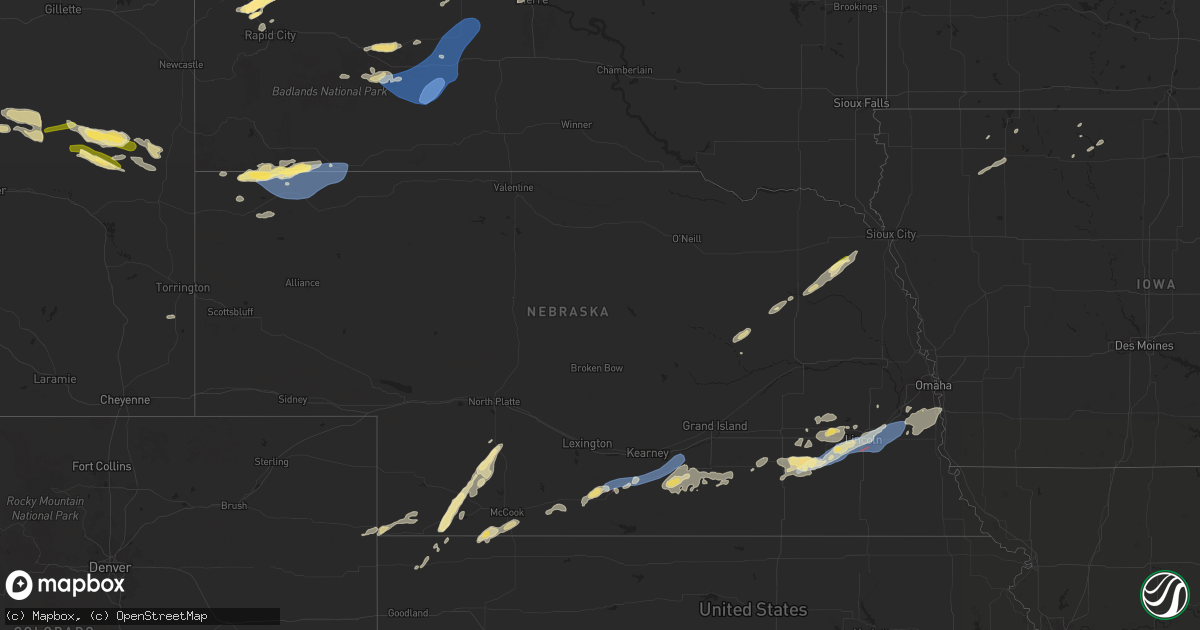
Hail Map in Nebraska on July 1, 2024
Get this storm
July 1 map
$229
one time, instant access
Download today. No call, no setup
Keep the $229
Bought the map and want the full workflow? Apply the entire $229 to a subscription within 7 days. None of it is wasted.
Every map, not just this one
This buys you this map. Subscription and you get every map we run, in the markets you choose from a few cities to whole states to nationwide. Plus real-time alerts the moment a storm fires.
Contact data
Name, contact info, occupancy, even credit band for addresses in the footprint. You go from where it hit to who to call.
Become the source they trust
Unlimited branding weather history reports on demand. You already have the documented answer ready for the property owner, and you are the one who showed up with it.
Property data and RoofTrace estimates
Pull up any address you have got, its value and the exact code rules for that jurisdiction, straight from One Click Code. Then RoofTrace estimates the squares, pitch, and roof value, priced the way you price.
Storm reports in Nebraska
Nebraska
| Date | Description |
|---|---|
| 07/01/20246:58 PM CDT | Public report via social media of a fence down in axtell and damage to a home. Time estimated based on radar. |
| 07/01/20246:57 PM CDT | A local report indicates 66 MPH wind near 2 SW Axtell |
| 07/01/20246:55 PM CDT | Awos station khde holdrege airport. |
| 07/01/20246:39 PM CDT | From wl-holdrege3.44ssw. |
| 07/01/20246:38 PM CDT | Social media report of 1-2 inch in diameter branches down south of the fairgrounds. Time estimated based on radar. |
| 07/01/20246:30 PM CDT | A local report indicates 61 MPH wind near 6 WNW Atlanta |
| 07/01/20246:29 PM CDT | Estimated location of trained spotter reporting a brief touchdown of a tornado. |
| 07/01/20246:09 PM CDT | A tornado was on the ground temporarily... Dropping in and out with lots of rotation. |
| 07/01/20245:51 PM CDT | Storm chaser reports brief touchdown of a rope tornado 2-3 miles north of beaver city. |
| 07/01/20245:45 PM CDT | Pictures via social media of large visibly healthy tree snapped. Time estimated from radar. |
| 07/01/20245:35 PM CDT | Corrects time of previous tstm wnd gst report from 6 sse holbrook. |
| 07/01/20245:32 PM CDT | A local report indicates 58 MPH wind near 6 SSE Holbrook |
| 07/01/20244:43 PM CDT | Spotter report of 50-60 mph winds and heavy rain reducing visibility down to 0.25 mile. |
| 07/01/20243:47 PM CDT | Asos station kcdr chadron airport - cdr. |
| 07/01/202411:51 AM CDT | Roof ripped off a farm building... Extensive tree damage... And silo destroyed. Potential tornado damage. Time estimated from radar. |
| 07/01/202412:05 AM CDT | Numerous large trees split/limbs down. |
| 07/01/202412:03 AM CDT | Gas station awning blown down. |
| 06/30/202411:45 PM CDT | A local report indicates 58 MPH wind near 2 SE Pleasant Dale |
| 06/30/202410:46 PM CDT | Ef-0. A narrow area... Less than 100 yards across with several damaged trees and large limbs was documented along highway 15. Roads off of the highway near this locatio |
| 06/30/202410:23 PM CDT | Via personal weather station. |
| 06/30/20249:45 PM CDT | Report from mping: 1-inch tree limbs broken; shingles blown off. |
| 06/30/20248:48 PM CDT | A local report indicates 59 MPH wind near 4 ESE Hastings |
| 06/30/20248:32 PM CDT | A local report indicates 1.00 inch wind near Wayne |
| 06/30/20248:25 PM CDT | A local report indicates 1.00 inch wind near Wayne |
| 06/30/20247:40 PM CDT | Delayed report. Via mping shingles blown off and one inch tree limbs broken. |
| 06/30/20247:24 PM CDT | Estimated location of rope tornado. |
| 06/30/20247:23 PM CDT | A tree was split in half & tree fell on neighbors garage in east axtell. |
| 06/30/20247:12 PM CDT | 6 inch tree limbs reported broken in the city of minden. Time estimated from radar. |
| 06/30/20247:08 PM CDT | A brief tornado. |
| 06/30/20247:05 PM CDT | Several branches down across the yard |
| 06/30/20247:03 PM CDT | Tree branches down on the highway in axtell via storm chaser. |
All States Impacted by Hail Map on July 1, 2024
Cities Impacted by Hail Map on July 1, 2024
- Limon, CO
- Matheson, CO
- Genoa, CO
- Hugo, CO
- Waldorf, MD
- Bryantown, MD
- Hughesville, MD
- Charlotte Hall, MD
- Mechanicsville, MD
- Forsyth, MT
- Hysham, MT
- Sanders, MT
- Dayton, WY
- Yoder, WY
- Piedmont, SD
- Sturgis, SD
- Fort Meade, SD
- Deadwood, SD
- Bird City, KS
- Harrison, NE
- Wewahitchka, FL
- San Manuel, AZ
- Black Hawk, SD
- Rapid City, SD
- Whitney, NE
- Chadron, NE
- McDonald, KS
- Crawford, NE
- Max, NE
- Gladstone, ND
- Midland, SD
- San Simon, AZ
- Oelrichs, SD
- Lefor, ND
- Regent, ND
- Dickinson, ND
- Taylor, ND
- Richardton, ND
- Lance Creek, WY
- Eagle Butte, SD
- Greybull, WY
- Belen, NM
- Bosque, NM
- Jarales, NM
- Los Lunas, NM
- Pine Ridge, SD
- Stratton, NE
- Worland, WY
- Hayes, SD
- Thermopolis, WY
- Hay Springs, NE
- Rushville, NE
- Silver City, NM
- Arenas Valley, NM
- Herndon, KS
- Palisade, NE
- Hayes Center, NE
- Trenton, NE
- Batesland, SD
- Culbertson, NE
- Haigler, NE
- Wray, CO
- Scenic, SD
- Willcox, AZ
- Hazen, ND
- New Salem, ND
- McCook, NE
- Wall, SD
- Trail City, SD
- Quinn, SD
- Beulah, ND
- Maywood, NE
- Stanton, ND
- Center, ND
- Kadoka, SD
- Indianola, NE
- Panama City, FL
- Pierre, SD
- Roberts, ID
- Philip, SD
- Parks, NE
- Wellfleet, NE
- Menan, ID
- Edgemont, SD
- Washburn, ND
- Benkelman, NE
- Rexburg, ID
- Interior, SD
- Cambridge, NE
- Onida, SD
- Linton, ND
- Hazelton, ND
- Fort Pierre, SD
- Belvidere, SD
- Holbrook, NE
- Wanblee, SD
- Long Valley, SD
- White River, SD
- Denhoff, ND
- Mcclusky, ND
- Braddock, ND
- Socorro, NM
- Okaton, SD
- Oxford, NE
- Edison, NE
- Arapahoe, NE
- Steele, ND
- Bertrand, NE
- Casper, WY
- Kaycee, WY
- Driscoll, ND
- Atlanta, NE
- Holdrege, NE
- Midwest, WY
- Buckhorn, NM
- Tularosa, NM
- Glenrock, WY
- Cedar Rapids, NE
- Albion, NE
- Funk, NE
- Superior, AZ
- Loomis, NE
- Axtell, NE
- Minden, NE
- Heartwell, NE
- Douglas, WY
- Kenesaw, NE
- Manderson, SD
- Madison, NE
- Newman Grove, NE
- Meadow Grove, NE
- Lindsay, NE
- McNeal, AZ
- Norfolk, NE
- Battle Creek, NE
- Stanton, NE
- Campbell, NE
- Holstein, NE
- Hoskins, NE
- Winside, NE
- Fullerton, NE
- Shawnee, WY
- Wayne, NE
- Upland, NE
- Roseland, NE
- Hastings, NE
- Bladen, NE
- Juniata, NE
- Wakefield, NE
- Glenvil, NE
- Ayr, NE
- Inland, NE
- Lost Springs, WY
- Emerson, NE
- Allen, NE
- Fairfield, NE
- Clay Center, NE
- Harvard, NE
- Lusk, WY
- Saronville, NE
- Sutton, NE
- Grafton, NE
- Utica, NE
- Beaver Crossing, NE
- Sutherland, IA
- Fairmont, NE
- Whittemore, IA
- Exeter, NE
- Burt, IA
- Milford, IA
- Everly, IA
- Titonka, IA
- Geneva, NE
- Royal, IA
- Waco, NE
- York, NE
- Seward, NE
- Peterson, IA
- Spencer, IA
- Greenville, IA
- Friend, NE
- Cordova, NE
- Milligan, NE
- Milford, NE
- Goehner, NE
- Dorchester, NE
- Terril, IA
- Pleasant Dale, NE
- Crete, NE
- Garland, NE
- Swea City, IA
- Denton, NE
- Lincoln, NE
- Bancroft, IA
- Lone Rock, IA
- Malcolm, NE
- Martell, NE
- Roca, NE
- Walton, NE
- Staplehurst, NE
- Bee, NE
- Waverly, NE
- Greenwood, NE
- Weeping Water, NE
- Alvo, NE
- Murdock, NE
- Louisville, NE
- Manley, NE
- Elmwood, NE
- Raymond, NE
- Nehawka, NE
- Murray, NE
- Ithaca, NE
- Wahoo, NE
- Ceresco, NE
- Plattsmouth, NE
- Eagle, NE
- Bennet, NE
- Davey, NE
- Ashland, NE
- Springfield, NE
- Gretna, NE
- Cedar Creek, NE
- Bellevue, NE
- Papillion, NE
- Glenwood, IA
- Pacific Junction, IA


