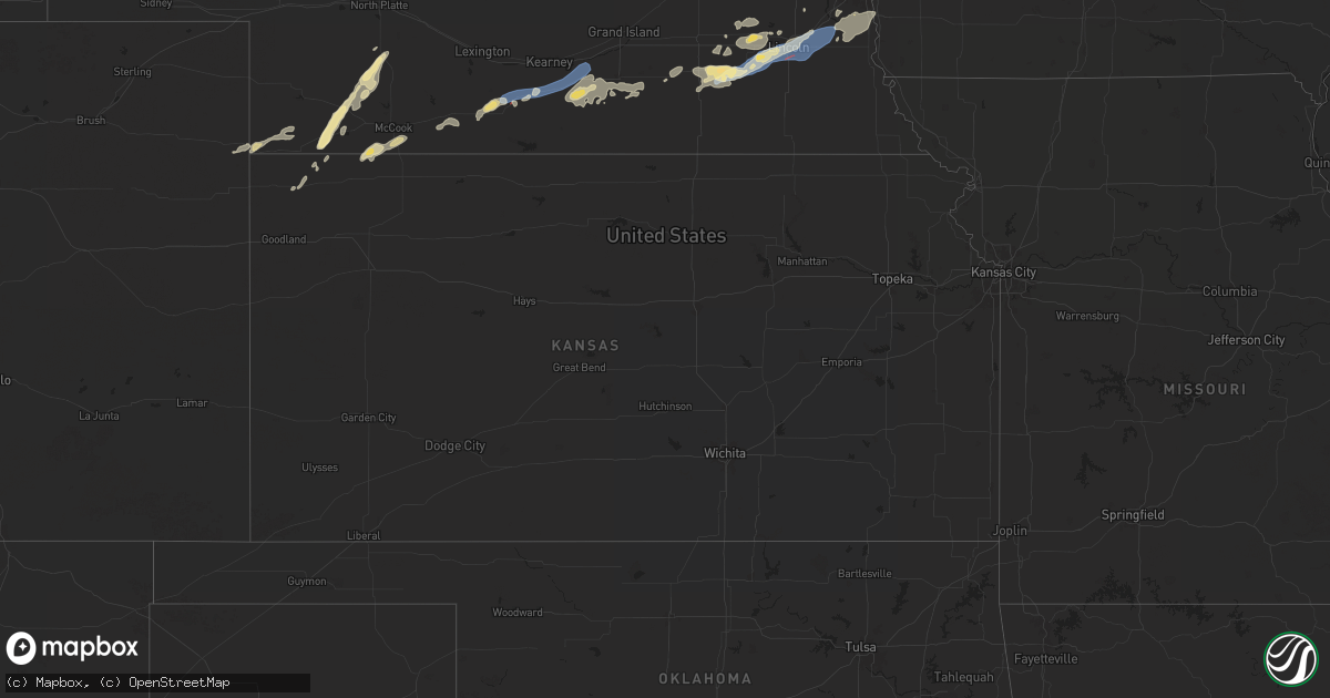
Hail Map in Kansas on July 1, 2024
Get this storm
July 1 map
$229
one time, instant access
Download today. No call, no setup
Keep the $229
Bought the map and want the full workflow? Apply the entire $229 to a subscription within 7 days. None of it is wasted.
Every map, not just this one
This buys you this map. Subscription and you get every map we run, in the markets you choose from a few cities to whole states to nationwide. Plus real-time alerts the moment a storm fires.
Contact data
Name, contact info, occupancy, even credit band for addresses in the footprint. You go from where it hit to who to call.
Become the source they trust
Unlimited branding weather history reports on demand. You already have the documented answer ready for the property owner, and you are the one who showed up with it.
Property data and RoofTrace estimates
Pull up any address you have got, its value and the exact code rules for that jurisdiction, straight from One Click Code. Then RoofTrace estimates the squares, pitch, and roof value, priced the way you price.
Storm reports in Kansas
Kansas
| Date | Description |
|---|---|
| 07/01/20245:45 PM CDT | Mesonet station up840 9.0 w winona |
| 07/01/20245:34 PM CDT | Ambient weather station ostmeyer in eastern colby reported 64 mph gust. |
| 07/01/20245:33 PM CDT | Ks mesonet site reported 61 mph gust. |
| 07/01/20245:31 PM CDT | Delayed report of em weather station recording a 86 mph gust. Damage was also reported around colby. |
| 07/01/20245:31 PM CDT | Delayed report from em of structural damage to a shed... Windows blown out of trucks... And tree limbs blown down. |
All States Impacted by Hail Map on July 1, 2024
Cities Impacted by Hail Map on July 1, 2024
- Limon, CO
- Matheson, CO
- Genoa, CO
- Hugo, CO
- Waldorf, MD
- Bryantown, MD
- Hughesville, MD
- Charlotte Hall, MD
- Mechanicsville, MD
- Forsyth, MT
- Hysham, MT
- Sanders, MT
- Dayton, WY
- Yoder, WY
- Piedmont, SD
- Sturgis, SD
- Fort Meade, SD
- Deadwood, SD
- Bird City, KS
- Harrison, NE
- Wewahitchka, FL
- San Manuel, AZ
- Black Hawk, SD
- Rapid City, SD
- Whitney, NE
- Chadron, NE
- McDonald, KS
- Crawford, NE
- Max, NE
- Gladstone, ND
- Midland, SD
- San Simon, AZ
- Oelrichs, SD
- Lefor, ND
- Regent, ND
- Dickinson, ND
- Taylor, ND
- Richardton, ND
- Lance Creek, WY
- Eagle Butte, SD
- Greybull, WY
- Belen, NM
- Bosque, NM
- Jarales, NM
- Los Lunas, NM
- Pine Ridge, SD
- Stratton, NE
- Worland, WY
- Hayes, SD
- Thermopolis, WY
- Hay Springs, NE
- Rushville, NE
- Silver City, NM
- Arenas Valley, NM
- Herndon, KS
- Palisade, NE
- Hayes Center, NE
- Trenton, NE
- Batesland, SD
- Culbertson, NE
- Haigler, NE
- Wray, CO
- Scenic, SD
- Willcox, AZ
- Hazen, ND
- New Salem, ND
- McCook, NE
- Wall, SD
- Trail City, SD
- Quinn, SD
- Beulah, ND
- Maywood, NE
- Stanton, ND
- Center, ND
- Kadoka, SD
- Indianola, NE
- Panama City, FL
- Pierre, SD
- Roberts, ID
- Philip, SD
- Parks, NE
- Wellfleet, NE
- Menan, ID
- Edgemont, SD
- Washburn, ND
- Benkelman, NE
- Rexburg, ID
- Interior, SD
- Cambridge, NE
- Onida, SD
- Linton, ND
- Hazelton, ND
- Fort Pierre, SD
- Belvidere, SD
- Holbrook, NE
- Wanblee, SD
- Long Valley, SD
- White River, SD
- Denhoff, ND
- Mcclusky, ND
- Braddock, ND
- Socorro, NM
- Okaton, SD
- Oxford, NE
- Edison, NE
- Arapahoe, NE
- Steele, ND
- Bertrand, NE
- Casper, WY
- Kaycee, WY
- Driscoll, ND
- Atlanta, NE
- Holdrege, NE
- Midwest, WY
- Buckhorn, NM
- Tularosa, NM
- Glenrock, WY
- Cedar Rapids, NE
- Albion, NE
- Funk, NE
- Superior, AZ
- Loomis, NE
- Axtell, NE
- Minden, NE
- Heartwell, NE
- Douglas, WY
- Kenesaw, NE
- Manderson, SD
- Madison, NE
- Newman Grove, NE
- Meadow Grove, NE
- Lindsay, NE
- McNeal, AZ
- Norfolk, NE
- Battle Creek, NE
- Stanton, NE
- Campbell, NE
- Holstein, NE
- Hoskins, NE
- Winside, NE
- Fullerton, NE
- Shawnee, WY
- Wayne, NE
- Upland, NE
- Roseland, NE
- Hastings, NE
- Bladen, NE
- Juniata, NE
- Wakefield, NE
- Glenvil, NE
- Ayr, NE
- Inland, NE
- Lost Springs, WY
- Emerson, NE
- Allen, NE
- Fairfield, NE
- Clay Center, NE
- Harvard, NE
- Lusk, WY
- Saronville, NE
- Sutton, NE
- Grafton, NE
- Utica, NE
- Beaver Crossing, NE
- Sutherland, IA
- Fairmont, NE
- Whittemore, IA
- Exeter, NE
- Burt, IA
- Milford, IA
- Everly, IA
- Titonka, IA
- Geneva, NE
- Royal, IA
- Waco, NE
- York, NE
- Seward, NE
- Peterson, IA
- Spencer, IA
- Greenville, IA
- Friend, NE
- Cordova, NE
- Milligan, NE
- Milford, NE
- Goehner, NE
- Dorchester, NE
- Terril, IA
- Pleasant Dale, NE
- Crete, NE
- Garland, NE
- Swea City, IA
- Denton, NE
- Lincoln, NE
- Bancroft, IA
- Lone Rock, IA
- Malcolm, NE
- Martell, NE
- Roca, NE
- Walton, NE
- Staplehurst, NE
- Bee, NE
- Waverly, NE
- Greenwood, NE
- Weeping Water, NE
- Alvo, NE
- Murdock, NE
- Louisville, NE
- Manley, NE
- Elmwood, NE
- Raymond, NE
- Nehawka, NE
- Murray, NE
- Ithaca, NE
- Wahoo, NE
- Ceresco, NE
- Plattsmouth, NE
- Eagle, NE
- Bennet, NE
- Davey, NE
- Ashland, NE
- Springfield, NE
- Gretna, NE
- Cedar Creek, NE
- Bellevue, NE
- Papillion, NE
- Glenwood, IA
- Pacific Junction, IA


