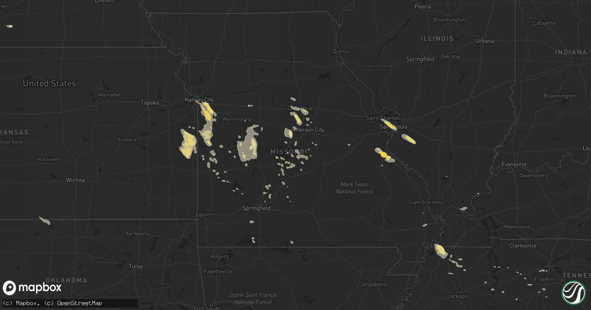
Hail Map in Missouri on July 1, 2015
Get this storm
July 1 map
$229
one time, instant access
Download today. No call, no setup
Keep the $229
Bought the map and want the full workflow? Apply the entire $229 to a subscription within 7 days. None of it is wasted.
Every map, not just this one
This buys you this map. Subscription and you get every map we run, in the markets you choose from a few cities to whole states to nationwide. Plus real-time alerts the moment a storm fires.
Contact data
Name, contact info, occupancy, even credit band for addresses in the footprint. You go from where it hit to who to call.
Become the source they trust
Unlimited branding weather history reports on demand. You already have the documented answer ready for the property owner, and you are the one who showed up with it.
Property data and RoofTrace estimates
Pull up any address you have got, its value and the exact code rules for that jurisdiction, straight from One Click Code. Then RoofTrace estimates the squares, pitch, and roof value, priced the way you price.
Storm reports in Missouri
Missouri
| Date | Description |
|---|---|
| 07/01/20156:58 PM CDT | Law enforcement reports rotation at 40th and woods chapel and i-70 also. Rotation lowering. |
| 07/01/20156:55 PM CDT | Tornado confirmed via broadcast media helicopter feed. Debris and transformers blown. |
| 07/01/20156:50 PM CDT | Trained spotter reporting lowering rotation at blackwell and shannodoah looking toward raytown. |
| 07/01/20156:33 PM CDT | Trained spotter reporting rotation directly over raytown 59th and woodson. |
| 07/01/20151:40 AM CDT | Delayed report...several trees down in chadwick. |
| 07/01/20151:15 AM CDT | Delayed report...a picture on social media of a tree snapped in rogersville. Time estimated. |
| 07/01/20151:00 AM CDT | Delayed report...several large trees uprooted and tree damage around the northview area. Pictures sent in from social media. Time estimated. |
| 07/01/201512:56 AM CDT | Multiple trees down. A house with minor shingle and roof damage. |
| 07/01/201512:56 AM CDT | Large tree uprooted. Power lines down. |
| 07/01/201512:50 AM CDT | Report of a large tree falling through a residence near quail road and highway bb 2 miles south of nevada. No injuries. |
| 07/01/201512:40 AM CDT | A large tree fell into a house near quail road and highway bb. Tree fell through the living room trapping a person in the home. |
| 07/01/201512:15 AM CDT | Delayed report...a large tree was blown down onto wooden fence and storage outbuilding causing damage. Picture from social media and time estimated. |
| 07/01/201512:01 AM CDT | Tree branches down. Power out |
| 06/30/201511:57 PM CDT | Delayed report...numerous reports and picture from social media of large trees blown down around lebanon. A couple trees onto outbuildings and fences causing minor dama |
| 06/30/201511:54 PM CDT | Large limbs down into powerlines at rafe road in lebanon. |
| 06/30/201511:50 PM CDT | Facebook post of tree that has fallen on an residents ac unit near the city of metz. |
| 06/30/201511:42 PM CDT | Delayed report...numerous reports and picture from social media of large trees blown down around lebanon. A couple trees onto outbuildings and fences causing minor dama |
| 06/30/201510:55 PM CDT | A nws storm survey found a brief ef-0 tornado touched down near highway e near hayden. The tornado uprooted one tree and several large tree branches were blown down acr |
| 06/30/201510:45 PM CDT | Path of tree damage... Multiple trees stripped along e highway and county road 506 |
| 06/30/201510:45 PM CDT | Numerous trees reported blown down around dixon. |
| 06/30/201510:25 PM CDT | Reports of numerous trees and large limbs blown down on fairview and sequoia road in iberia. |
| 06/30/201510:20 PM CDT | Tree down on carol road |
| 06/30/201510:15 PM CDT | Two large trees down. |
| 06/30/201510:05 PM CDT | Trained storm chaser measured a 59 mph at the bagnell dam. |
| 06/30/201510:00 PM CDT | Multiple large trees down in warsaw |
| 06/30/201510:00 PM CDT | Report of fallen tree on road near saline valley. |
| 06/30/201510:00 PM CDT | Report of a path of multiple trees uprooted and blown down. Also damage to mobile homes. |
| 06/30/20159:56 PM CDT | Nws storm survey concluded that a ef1 tornado with a estimated maximum wind speed of 94 mph touched down 3 miles nw of warsaw. It had a path width of 1/4 to 1/2 mile wi |
| 06/30/20159:56 PM CDT | Nws storm survey concluded that a ef1 tornado with a estimated maximum wind speed of 94 mph touched down 3 miles nw of warsaw. It had a path width of 1/4 to 1/2 mile wi |
| 06/30/20159:53 PM CDT | 3-4 6 inch branches down in yard from trained spotter. |
| 06/30/20159:45 PM CDT | Report of tree over road near hittridge road near eldon. |
| 06/30/20159:42 PM CDT | A local report indicates 60 MPH wind near 1 ESE VICTORIA |
| 06/30/20159:41 PM CDT | Skylights broken at walmart just south of columbia with water flooding store. |
| 06/30/20159:35 PM CDT | Trees down blocking highway 135 south of stover. |
| 06/30/20159:35 PM CDT | 12 inch tree down on highway 52 |
| 06/30/20159:30 PM CDT | Mostly 1.25 inch hail with a few that were up to 3 inches. |
| 06/30/20159:30 PM CDT | Quarter size hail in lincoln |
| 06/30/20159:26 PM CDT | A local report indicates 60 MPH wind near 5 W HARRISONVILLE |
| 06/30/20159:20 PM CDT | 3 trees uprooted and a 2 foot diameter tree snapped approx 3 feet off the ground...time est from radar |
| 06/30/20159:15 PM CDT | Large tree branches down in ionia |
| 06/30/20159:15 PM CDT | Power lines down in cole camp. Also tree down... Unknown size |
| 06/30/20159:10 PM CDT | 6 inch tree limbs down in yard and neighbors. |
| 06/30/20159:03 PM CDT | Trees down on power lines. |
| 06/30/20159:00 PM CDT | Delayed report...large barn 100ft x 60ft destroyed with one wall remaining. Time estimated from radar. |
| 06/30/20158:40 PM CDT | Delayed report via facebook photo...tree uprooted and fell onto garage...time estimated |
| 06/30/20158:38 PM CDT | Deputy reports several utility poles down on hwy b between sacajawea and ragar rds. Time estimate by radar. |
| 06/30/20158:30 PM CDT | Delayed report...one foot diameter tree blown down |
| 06/30/20158:24 PM CDT | Deputy reported near the intersection of 32nd street and prairie road |
| 06/30/20158:20 PM CDT | Komu...via twitter. On georgetown drive just west of scott blvd. Time estimated. |
| 06/30/20158:05 PM CDT | Spotter reports tornado on ground at hwy 7 and hwy 58. |
| 06/30/20158:05 PM CDT | 2 to 3 inch tree limbs reported down near the 24000 block of hwy 58... Possibly due to tornado |
| 06/30/20157:58 PM CDT | Several large trees blown down in forest park as well as numerous large tree limbs. Some were blown down near lindell blvd and union. Time estimated. |
| 06/30/20157:48 PM CDT | Tree down near intersection of lindell and union. |
| 06/30/20157:45 PM CDT | Numerous small branches downed. |
| 06/30/20157:28 PM CDT | Several large tree limbs down across a neighborhood in st. Ann. |
All States Impacted by Hail Map on July 1, 2015
Cities Impacted by Hail Map on July 1, 2015
- Lambert, MT
- Circle, MT
- Grand Canyon, AZ
- Otter, MT
- Smithwick, SD
- Chadron, NE
- Hot Springs, SD
- Hay Springs, NE
- Buffalo Gap, SD
- Pine Ridge, SD
- Oral, SD
- Oelrichs, SD
- Campbell, NE
- Thermopolis, WY
- Kenansville, FL
- Saint Cloud, FL
- Chamberlain, SD
- Oacoma, SD
- Gregory, SD
- Pukwana, SD
- Platte, SD
- Reliance, SD
- Concho, AZ
- Custer, SD
- Edgemont, SD
- Newcastle, WY
- Lame Deer, MT
- Ashland, MT
- Springerville, AZ
- Hillsboro, MO
- De Soto, MO
- Carter, MT
- Geyser, MT
- Geraldine, MT
- Loma, MT
- Fort Benton, MT
- Myakka City, FL
- Glenrock, WY
- Wing, AL
- Grovespring, MO
- Laurel Hill, FL
- Baker, FL
- Linden, TN
- Sugar Tree, TN
- Parsons, TN
- Ganado, AZ
- Pulaski, TN
- Rushville, NE
- Dickson, TN
- Flagstaff, AZ
- Minden, NE
- Norton, KS
- Oberlin, KS
- Clayton, KS
- Jennings, KS
- Norcatur, KS
- Heber, AZ
- Winslow, AZ
- Colorado City, AZ
- Osage, WY
- Upton, WY
- Clermont, FL
- Ashland, MO
- Wooldridge, MO
- Columbia, MO
- Jefferson City, MO
- Jamestown, MO
- Hartsburg, MO
- Centertown, MO
- Ohatchee, AL
- Gadsden, AL
- Okeechobee, FL
- Weston, WY
- Moorcroft, WY
- Gillette, WY
- Rozet, WY
- Butler, MO
- Sedalia, MO
- Green Ridge, MO
- Sedona, AZ
- Shawnee, WY
- Lost Springs, WY
- Dudley, GA
- Dexter, GA
- Paola, KS
- Pleasanton, KS
- Mound City, KS
- Prescott, KS
- Fontana, KS
- Parker, KS
- Centerville, KS
- Osawatomie, KS
- La Cygne, KS
- Blue Mound, KS
- Louisburg, KS
- Saint Louis, MO
- Maryland Heights, MO
- Saint Ann, MO
- Bridgeton, MO
- Musselshell, MT
- Bassett, NE
- Winnett, MT
- Elkland, MO
- Buffalo, MO
- Fayette, AL
- Berry, AL
- Wakita, OK
- Manchester, OK
- Lusk, WY
- Harrison, NE
- Douglas, WY
- Manville, WY
- Fort Myers, FL
- Parks, AZ
- Williams, AZ
- Dry Creek, LA
- Kaibeto, AZ
- Independence, MO
- Greenwood, MO
- Lees Summit, MO
- Kansas City, MO
- Winter Garden, FL
- Kissimmee, FL
- Davenport, FL
- Orlando, FL
- Bertrand, NE
- Braithwaite, LA
- Belle Chasse, LA
- Mora, MO
- Smithton, MO
- Sheldon, MO
- Jerico Springs, MO
- Richey, MT
- Bloomfield, MT
- Savage, MT
- Adrian, MO
- Westcliffe, CO
- Osceola, MO
- Lowry City, MO
- Quincy, MO
- Deepwater, MO
- Broken Bow, NE
- Comstock, NE
- Lebanon, MO
- Phillipsburg, MO
- Cuba, NM
- Clyo, GA
- Springfield, GA
- Warsaw, MO
- Lincoln, MO
- Indiantown, FL
- Festus, MO
- Twin City, GA
- Eva, TN
- Jemez Springs, NM
- Garrett, WY
- Roach, MO
- Camdenton, MO
- Dickens, NE
- Saint Elizabeth, MO
- Ulman, MO
- Dixon, MO
- Iberia, MO
- Tuscumbia, MO
- Marshfield, MO
- Bloomsdale, MO
- Soperton, GA
- Avon Park, FL
- Lobelville, TN
- Brewton, AL
- Curtis, NE
- Frazer, MT
- Larslan, MT
- Peerless, MT
- Sebring, FL
- Evansville, WY
- Casper, WY
- Vail, AZ
- Roy, MT
- Naples, FL
- Zuni, NM
- Hickman, KY
- Union City, TN
- Troy, TN
- Burwell, NE
- Drexel, MO
- Harrisonville, MO
- Archie, MO
- Saint Francis, KS
- Strafford, MO
- Rives, TN
- Chambers, AZ
- Caliente, NV
- Sonoita, AZ
- Nashua, MT
- Clever, MO
- Billings, MO
- Highlandville, MO
- Crane, MO
- Santa Fe, TN
- Primm Springs, TN
- Ekalaka, MT
- Oconto, NE
- Mason City, NE
- Busby, MT
- Cape Coral, FL
- Bay Minette, AL
- Frostproof, FL
- Roundup, MT
- Worden, MT
- Athens, AL
- Madison, AL
- Lower Brule, SD
- Kansas City, KS
- Lake Wales, FL
- Goodspring, TN
- Vernon, AL
- Sulligent, AL
- Bardwell, KY
- Cunningham, KY
- Kevil, KY
- Barlow, KY
- Wickliffe, KY
- Paducah, KY
- La Center, KY
- Melber, KY
- Brusett, MT
- Happy Jack, AZ
- McDavid, FL
- Greenville, FL
- Madison, FL
- Arthur, NE
- Sundance, WY
- Saraland, AL
- Axis, AL
- Creola, AL
- Holbrook, AZ
- Rockville, MO
- Schell City, MO
- Fence Lake, NM
- Wauchula, FL
- Fort Meade, FL
- Forsyth, MT
- Buffalo, WY
- Hardin, MT
- Crow Agency, MT
- Birney, MT
- Keystone Heights, FL
- Prospect, TN
- Braman, OK
- Blackwell, OK
- Ansley, NE
- Marion, KY
- Quemado, NM
- Rich Hill, MO
- Hume, MO
- Hinsdale, MT
- Alpine, AZ
- Hollywood, AL
- Stevenson, AL
- Jordan, MT
- Pleasant Hill, MO
- Raymore, MO
- Kaiser, MO
- Osage Beach, MO
- El Dorado Springs, MO
- Trenton, TN
- Dyer, TN
- Statesboro, GA
- New Bloomfield, MO
- Anthony, KS
- Glasgow, MT
- Perry, GA
- California, MO
- Russellville, MO
- Stockton, MO
- Lincoln, AL
- Eastaboga, AL
- Western Grove, AR
- Saint Joe, AR
- Hasty, AR
- Counselor, NM
- La Jara, NM
- Regina, NM
- Wolf Point, MT
- Pinon, AZ
- Melrose, FL
- Waldo, FL
- Starke, FL
- Eagar, AZ
- Sand Springs, MT
- Vida, MT
- Harrold, SD
- Medford, OK
- Lehigh Acres, FL
- Lindrith, NM
- Freeman, MO
- Peculiar, MO
- Garden City, MO
- Grandview, MO
- Lone Jack, MO
- Albertville, AL
- Sargent, NE
- Pine Grove, LA
- Denham Springs, LA
- Greenwell Springs, LA
- Clinton, LA
- Greensburg, LA
- Volborg, MT
- Haines City, FL
- Walker, MO
- Nevada, MO
- Buffalo, SD
- Hopkinsville, KY
- Freeburg, IL
- Mascoutah, IL
- New Athens, IL
- Lohman, MO
- Harrisburg, MO
- Fayette, MO
- Chinook, MT
- Trafford, AL
- Hartville, MO
- Milo, MO
- Lance Creek, WY
- Westerville, NE
- Harlem, MT
- Hays, MT
- Rockledge, GA
- Sikeston, MO
- Bertrand, MO
- Montreal, MO
- Linn Creek, MO
- Hohenwald, TN
- Leslie, MO
- Sullivan, MO
- Adrian, GA
- Sarasota, FL
- Zolfo Springs, FL
- Polacca, AZ
- Bonita Springs, FL
- Richland, MT
- French Village, MO
- Hartselle, AL
- Clewiston, FL
- Aragon, NM
- Carterville, IL
- Columbia, TN
- Weaubleau, MO
- Dresden, TN
- Sharon, TN
- Valdosta, GA
- Pinetta, FL
- Florissant, CO
- Upland, NE
- Burke, SD
- Earth City, MO
- Saint Charles, MO
- East Saint Louis, IL
- Andalusia, AL
- Calhoun, MO
- Richards, MO
- Kennebec, SD
- Columbiana, AL
- Shelby, AL
- Martin, TN
- Rawlins, WY
- Lenzburg, IL
- Marissa, IL
- Belleville, IL
- Eldridge, MO
- Glendive, MT
- Tarrytown, GA
- Bon Aqua, TN
- Lyles, TN
- Loxahatchee, FL
- Keams Canyon, AZ
- Montrose, GA
- Cochran, GA
- Chester, GA
- Eugene, MO
- Eldon, MO
- Henley, MO
- Reeds Spring, MO
- Branson, MO
- Gallina, NM
- Ionia, MO
- Wheatland, MO
- Windsor, MO
- Edwards, MO
- Clinton, MO
- Cole Camp, MO
- Smithton, IL
- Millstadt, IL
- Freeburg, MO
- Koeltztown, MO
- Ponca City, OK
- Arcadia, FL
- Spring Hill, TN
- Estero, FL
- Ochopee, FL
- Kanab, UT
- McKenzie, TN
- Waynesville, MO
- Richland, MO
- Metropolis, IL
- Ledger, MT
- Whiteman Air Force Base, MO
- Knob Noster, MO
- Dadeville, MO
- Brooksville, FL
- Meta, MO
- Boaz, KY
- Snowflake, AZ
- Chester, MT
- Greenfield, MO
- Wilsonville, NE
- Holladay, TN
- Westport, TN
- Collinsville, AL
- Barnett, MO
- Latham, MO
- Rocheport, MO
- Fulton, MO
- Gainesville, MO
- Lewisburg, TN
- Sumner, NE
- Taylor, NE
- Brinktown, MO
- Pagosa Springs, CO
- Hickory, MS
- Wright, WY
- Riceville, TN
- Athens, TN
- Toney, AL
- Guffey, CO
- Hotevilla, AZ
- Pride, LA
- Oran, MO
- Benton, MO
- Blue Eye, MO
- Waverly, TN
- Nashville, TN
- Stoutland, MO
- Metter, GA
- Greenfield, TN
- Falkville, AL
- Oglala, SD
- Brentwood, TN
- Lucedale, MS
- Argyle, MO
- Montrose, MO
- New Orleans, LA
- Meraux, LA
- Chalmette, LA
- Ardmore, AL
- Ardmore, TN
- New Leipzig, ND
- Pinehill, NM
- Harpersville, AL
- Baton Rouge, LA
- Crocker, MO
- McEwen, TN
- Woodbury, GA
- Lake Park, GA
- Rosiclare, IL
- Long Lane, MO
- Fair Grove, MO
- Huntsville, AL
- Sweet Springs, MO
- Bonne Terre, MO
- Walnut Grove, MO
- Appleton City, MO
- Patagonia, AZ
- Second Mesa, AZ
- Brumley, MO
- Holts Summit, MO
- Ismay, MT
- Plevna, MT
- Kaycee, WY
- Conrad, MT
- Brady, MT
- Custer, MT
- Broadus, MT
- Recluse, WY


