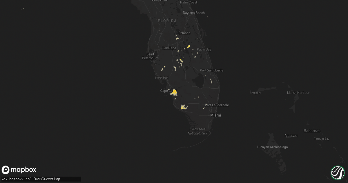
Hail Map on July 1, 2015
Get this storm
July 1 map
$229
one time, instant access
Download today. No call, no setup
Keep the $229
Bought the map and want the full workflow? Apply the entire $229 to a subscription within 7 days. None of it is wasted.
Every map, not just this one
This buys you this map. Subscription and you get every map we run, in the markets you choose from a few cities to whole states to nationwide. Plus real-time alerts the moment a storm fires.
Contact data
Name, contact info, occupancy, even credit band for addresses in the footprint. You go from where it hit to who to call.
Become the source they trust
Unlimited branding weather history reports on demand. You already have the documented answer ready for the property owner, and you are the one who showed up with it.
Property data and RoofTrace estimates
Pull up any address you have got, its value and the exact code rules for that jurisdiction, straight from One Click Code. Then RoofTrace estimates the squares, pitch, and roof value, priced the way you price.
States Impacted by Hail Map on July 1, 2015
Storm reports
Tennessee
| Date | Description |
|---|---|
| 07/01/20152:17 PM CDT | Trees down on highway 110 - ardmore highway. |
| 07/01/20152:13 PM CDT | Trees reported down by law enforcement. |
| 07/01/20151:45 PM CDT | Large branch snapped and estimated wind gust of 50 mph |
| 07/01/20151:42 PM CDT | Several trees down |
| 07/01/20151:30 PM CDT | Two trees down. One tree was on collier ave and the other tree was 1 mile south of the shelbyville municipal airport. |
| 07/01/201512:28 PM CDT | Trees down blocking the road near the intersection of beechcroft rd and dr robertson rd. |
| 07/01/201512:12 PM CDT | Large tree down on clarksville pike |
| 07/01/201511:43 AM CDT | Delayed report. Trees blown down on highway 48n between dickson and charlotte. |
| 07/01/201511:42 AM CDT | Trees down near mile 171 on i-40 south of dickson |
| 07/01/201511:42 AM CDT | Trees down along eno road and hwy 48 south |
| 07/01/201511:40 AM CDT | Trees down along eno road and hwy 48 south |
| 07/01/201511:30 AM CDT | Delayed report. Barn roof blown off on manley loop. |
| 07/01/201511:20 AM CDT | Several trees down and power outages in mcewen |
| 07/01/201511:08 AM CDT | Several trees down and power outages in waverly... Including a tree on a house on duffle street. |
| 07/01/201510:40 AM CDT | Multiple trees down and roof blown off house near reynoldsburg and french roads. Time is radar estimated. |
| 07/01/201510:25 AM CDT | Multiple trees down and roof blown off house near reynoldsburg and french roads. Time is radar estimated. |
| 07/01/20156:00 AM CDT | Wsmv-tv reported a tree blown down on woodmont blvd at granny white pike |
| 07/01/20153:55 AM CDT | Wkrn-tv reported several trees blown down across ashland city. A tree fell on top of a car at 119 w mcquarry st. Other trees were blown down on fairgrounds road and bel |
| 07/01/201512:55 AM CDT | Wsmv-tv reported a tree blown down at woodmont blvd and granny white pike |
| 06/30/201511:15 PM CDT | Public report of trees down along highway 54 in dresden. Report received via twitter from wbbj jackson tennessee weather department. |
| 06/30/201510:45 PM CDT | Trees and powerlines down around the city...time estimated based on radar and reports. |
Vermont
| Date | Description |
|---|---|
| 07/01/20153:27 PM CDT | Large tree down at intersection of south stream road and coleville road. Time estimated by radar. |
North Dakota
| Date | Description |
|---|---|
| 06/30/201510:06 PM CDT | Estimated 60 mph wind gusts. |
| 06/30/20159:55 PM CDT | Straight line winds. Also 0.75 inches of rainfall with the thunderstorm. |
Nevada
| Date | Description |
|---|---|
| 06/30/20159:50 PM CDT | Tikaboo peak measured a 62 mph thunderstorm wind gust. |
Mississippi
| Date | Description |
|---|---|
| 07/01/20154:10 PM CDT | Large tree downed along old foxworth rd |
Georgia
| Date | Description |
|---|---|
| 07/01/20156:05 PM CDT | Counyt sheriff reported wind damage to awning at the law enforcment complex in statenville. Severeal trees were also blown down within the statenville area. |
| 07/01/20155:22 PM CDT | The broadcast media relayed a report of a tree down on power lines on west johnston street in forsyth. Power was out across the city of forsyth. |
| 06/30/201510:51 PM CDT | Tree down on stillson-leefield rd near the intersection of spring creek rd. Time estimated from radar |
| 06/30/20159:59 PM CDT | Tree down on wood valley circle road |
| 06/30/20159:33 PM CDT | Tree down on stillson-leefield rd near the intersection of spring creek rd. Time estimated from radar |
| 06/30/20159:16 PM CDT | Large tree down at 700 block pine straw ct |
| 06/30/20159:16 PM CDT | Tree down on wood valley circle road |
| 06/30/20159:15 PM CDT | Tree down across road at 700 block of w jones ave |
| 06/30/20158:58 PM CDT | Tree down on hwy 80 near intersection with reddick rd |
| 06/30/20158:25 PM CDT | Multiple trees down near highway 86 and midway road. |
| 06/30/20157:50 PM CDT | 911 call center has received a report of 1 tree down on eastman road as well as several calls regarding a few downed powerlines. Employee from pilot travel center near |
South Carolina
| Date | Description |
|---|---|
| 06/30/201510:34 PM CDT | Sc highway patrol reported a tree down at i-95 near us-17. |
| 06/30/201510:34 PM CDT | The town of ridgeland reports multiple trees and large tree limbs down around ridgeland. Some were across roadways and others were down on power lines. The sign of a fa |
| 06/30/201510:34 PM CDT | Jasper county 911 center reported a tree down at old fordsville rd and captain bill rd. |
| 06/30/201510:34 PM CDT | Sc highway patrol reported a tree down at logan st and azalea ave. |
Alabama
| Date | Description |
|---|---|
| 07/01/20153:48 PM CDT | Trees down on hwy 431 at wellington rd |
| 07/01/20152:54 PM CDT | Tree down on deams ferry rd |
| 07/01/20152:45 PM CDT | Tree down on i59 near mm198 |
| 07/01/20152:24 PM CDT | A few trees down across the county on coutny hwy 1...county hwy 15...370 poplar tr. Spotter estimated winds gust to 40mph |
| 07/01/20152:15 PM CDT | Trees down on leeth gap rd |
| 07/01/20152:00 PM CDT | Trees down blocking antioch rd. |
| 07/01/201512:57 AM CDT | Quarter sized hail reported in hollywood. Relayed via social media. |
Massachusetts
| Date | Description |
|---|---|
| 07/01/20154:50 PM CDT | Tree down on house and tree down on wires along pierson road |
| 07/01/20158:00 AM CDT | Large limbs down on quaker meeting house road... Rte 6a and rte 130 |
| 07/01/20157:38 AM CDT | A local report indicates 61 MPH wind near EAST FALMOUTH |
Nebraska
| Date | Description |
|---|---|
| 07/01/20153:26 AM CDT | Delayed report |
| 07/01/20152:22 AM CDT | Delayed report. Several signs and tree branches down in bridgeport. |
| 07/01/20152:09 AM CDT | Delayed report |
| 06/30/201510:00 PM CDT | A local report indicates 1.00 inch wind near 11 SW MASON CITY |
Kansas
| Date | Description |
|---|---|
| 06/30/201511:40 PM CDT | 4 power poles down on 152 hwy. Numerous traffic signs and stops blown down. |
| 06/30/201511:10 PM CDT | A local report indicates 60 MPH wind near 1 N LA CYGNE |
South Dakota
| Date | Description |
|---|---|
| 07/01/20156:25 AM CDT | Quarter to ping pong ball size hail |
| 07/01/201512:24 AM CDT | A local report indicates 60 MPH wind near 13 W OGLALA |
| 07/01/201512:10 AM CDT | A local report indicates 69 MPH wind near 10 W EDGEMONT |
| 06/30/201511:55 PM CDT | A local report indicates 70 MPH wind near 14 NW EDGEMONT |
Arizona
| Date | Description |
|---|---|
| 07/01/20155:00 PM CDT | A lot of pea to dime sized hail with a few pieces to quarter size. |
| 07/01/20154:54 PM CDT | Public posted picture on facebook |
| 07/01/20154:40 PM CDT | A local report indicates 1.00 inch wind near FORT VALLEY |
| 07/01/20154:30 PM CDT | Hail broke a skylight and dented vehicles. |
| 07/01/20154:27 PM CDT | Measured golf ball sized hail. |
| 07/01/20154:00 PM CDT | 1 inch diamter hail near az snowbowl |
| 07/01/20152:57 AM CDT | Adot site ash fork hill at 1-40 |
| 06/30/201511:12 PM CDT | Azdot two guns at 1-40 |
| 06/30/201510:33 PM CDT | Adot jackrabbit at i-40 |
| 06/30/20159:18 PM CDT | Adot sr-77 14 mile hill... Az |
| 06/30/20157:45 PM CDT | Reported large tree toppled by winds onto part of a residence. Minimal damage to house. Crews had to be dispatched to sa and remove the tree. |
New York
| Date | Description |
|---|---|
| 07/01/20153:20 PM CDT | Tress and wires down at the intersection of rt. 67 and north hoosick street. |
| 07/01/20153:17 PM CDT | Route 67 closed at cottrell road due to downed wires. Time estimated by radar. |
| 07/01/20151:26 PM CDT | Trees and wires down near intersection of west state st. And hall ave. |
Montana
| Date | Description |
|---|---|
| 07/01/20156:00 PM CDT | Ground is covered with hail. |
| 07/01/20155:57 PM CDT | A local report indicates 60 MPH wind near 15 N POMPEYS PILLAR |
| 07/01/20154:38 PM CDT | Based off of photos from the reporting person and in discussion over the phone with the nws glasgow office... A 95 mph wind is estimated. Damage includes a metal pole bar (gg |
| 07/01/20154:05 PM CDT | Nickel size hail and a good size tree uprooted. Time of event radar estimated. |
| 07/01/20153:40 PM CDT | Second-hand report of grain silo blown down near mile marker 13 on hwy 223. Time and location of event estimated |
| 07/01/20153:40 PM CDT | Quarter size hail reported in the fort benton area by the chouteau county sheriff office. |
| 07/01/20153:35 PM CDT | Peak wind gust of 64 mph and 0.50-in hail. Some damage to buildings and trees. |
| 07/01/20153:19 PM CDT | Power pole knocked down during a thunderstorm. Time of event radar estimated. Location of event estimated. |
| 07/01/20153:15 PM CDT | Power pole knocked down during a thunderstorm. Time of event radar estimated. Location of event estimated. |
| 06/30/20159:10 PM CDT | A local report indicates 60 MPH wind near 5 NE BROADUS |
| 06/30/20158:50 PM CDT | A local report indicates 70 MPH wind near 7 S PLEVNA |
| 06/30/20158:30 PM CDT | Severe wind damage: 15 inch diameter trees in shelter belt snapped. One shed in the shelter belt had a door shredded and another shed lost its roof. |
| 06/30/20158:00 PM CDT | Several power poles snapped |
| 06/30/20157:59 PM CDT | A local report indicates 70 MPH wind near 10 ESE BUSBY |
| 06/30/20157:59 PM CDT | A local report indicates 1.00 inch wind near 10 ESE BUSBY |
| 06/30/20157:35 PM CDT | Observer reported gusty winds at least 60 mph |
| 06/30/20157:25 PM CDT | Less than 200 yards visibility. |
New Mexico
| Date | Description |
|---|---|
| 07/01/20156:00 PM CDT | A local report indicates 1.00 inch wind near 13 ESE CUBA |
Missouri
| Date | Description |
|---|---|
| 07/01/20156:58 PM CDT | Law enforcement reports rotation at 40th and woods chapel and i-70 also. Rotation lowering. |
| 07/01/20156:55 PM CDT | Tornado confirmed via broadcast media helicopter feed. Debris and transformers blown. |
| 07/01/20156:50 PM CDT | Trained spotter reporting lowering rotation at blackwell and shannodoah looking toward raytown. |
| 07/01/20156:33 PM CDT | Trained spotter reporting rotation directly over raytown 59th and woodson. |
| 07/01/20151:40 AM CDT | Delayed report...several trees down in chadwick. |
| 07/01/20151:15 AM CDT | Delayed report...a picture on social media of a tree snapped in rogersville. Time estimated. |
| 07/01/20151:00 AM CDT | Delayed report...several large trees uprooted and tree damage around the northview area. Pictures sent in from social media. Time estimated. |
| 07/01/201512:56 AM CDT | Multiple trees down. A house with minor shingle and roof damage. |
| 07/01/201512:56 AM CDT | Large tree uprooted. Power lines down. |
| 07/01/201512:50 AM CDT | Report of a large tree falling through a residence near quail road and highway bb 2 miles south of nevada. No injuries. |
| 07/01/201512:40 AM CDT | A large tree fell into a house near quail road and highway bb. Tree fell through the living room trapping a person in the home. |
| 07/01/201512:15 AM CDT | Delayed report...a large tree was blown down onto wooden fence and storage outbuilding causing damage. Picture from social media and time estimated. |
| 07/01/201512:01 AM CDT | Tree branches down. Power out |
| 06/30/201511:57 PM CDT | Delayed report...numerous reports and picture from social media of large trees blown down around lebanon. A couple trees onto outbuildings and fences causing minor dama |
| 06/30/201511:54 PM CDT | Large limbs down into powerlines at rafe road in lebanon. |
| 06/30/201511:50 PM CDT | Facebook post of tree that has fallen on an residents ac unit near the city of metz. |
| 06/30/201511:42 PM CDT | Delayed report...numerous reports and picture from social media of large trees blown down around lebanon. A couple trees onto outbuildings and fences causing minor dama |
| 06/30/201510:55 PM CDT | A nws storm survey found a brief ef-0 tornado touched down near highway e near hayden. The tornado uprooted one tree and several large tree branches were blown down acr |
| 06/30/201510:45 PM CDT | Numerous trees reported blown down around dixon. |
| 06/30/201510:45 PM CDT | Path of tree damage... Multiple trees stripped along e highway and county road 506 |
| 06/30/201510:25 PM CDT | Reports of numerous trees and large limbs blown down on fairview and sequoia road in iberia. |
| 06/30/201510:20 PM CDT | Tree down on carol road |
| 06/30/201510:15 PM CDT | Two large trees down. |
| 06/30/201510:05 PM CDT | Trained storm chaser measured a 59 mph at the bagnell dam. |
| 06/30/201510:00 PM CDT | Report of a path of multiple trees uprooted and blown down. Also damage to mobile homes. |
| 06/30/201510:00 PM CDT | Report of fallen tree on road near saline valley. |
| 06/30/201510:00 PM CDT | Multiple large trees down in warsaw |
| 06/30/20159:56 PM CDT | Nws storm survey concluded that a ef1 tornado with a estimated maximum wind speed of 94 mph touched down 3 miles nw of warsaw. It had a path width of 1/4 to 1/2 mile wi |
| 06/30/20159:56 PM CDT | Nws storm survey concluded that a ef1 tornado with a estimated maximum wind speed of 94 mph touched down 3 miles nw of warsaw. It had a path width of 1/4 to 1/2 mile wi |
| 06/30/20159:53 PM CDT | 3-4 6 inch branches down in yard from trained spotter. |
| 06/30/20159:45 PM CDT | Report of tree over road near hittridge road near eldon. |
| 06/30/20159:42 PM CDT | A local report indicates 60 MPH wind near 1 ESE VICTORIA |
| 06/30/20159:41 PM CDT | Skylights broken at walmart just south of columbia with water flooding store. |
| 06/30/20159:35 PM CDT | Trees down blocking highway 135 south of stover. |
| 06/30/20159:35 PM CDT | 12 inch tree down on highway 52 |
| 06/30/20159:30 PM CDT | Quarter size hail in lincoln |
| 06/30/20159:30 PM CDT | Mostly 1.25 inch hail with a few that were up to 3 inches. |
| 06/30/20159:26 PM CDT | A local report indicates 60 MPH wind near 5 W HARRISONVILLE |
| 06/30/20159:20 PM CDT | 3 trees uprooted and a 2 foot diameter tree snapped approx 3 feet off the ground...time est from radar |
| 06/30/20159:15 PM CDT | Large tree branches down in ionia |
| 06/30/20159:15 PM CDT | Power lines down in cole camp. Also tree down... Unknown size |
| 06/30/20159:10 PM CDT | 6 inch tree limbs down in yard and neighbors. |
| 06/30/20159:03 PM CDT | Trees down on power lines. |
| 06/30/20159:00 PM CDT | Delayed report...large barn 100ft x 60ft destroyed with one wall remaining. Time estimated from radar. |
| 06/30/20158:40 PM CDT | Delayed report via facebook photo...tree uprooted and fell onto garage...time estimated |
| 06/30/20158:38 PM CDT | Deputy reports several utility poles down on hwy b between sacajawea and ragar rds. Time estimate by radar. |
| 06/30/20158:30 PM CDT | Delayed report...one foot diameter tree blown down |
| 06/30/20158:24 PM CDT | Deputy reported near the intersection of 32nd street and prairie road |
| 06/30/20158:20 PM CDT | Komu...via twitter. On georgetown drive just west of scott blvd. Time estimated. |
| 06/30/20158:05 PM CDT | 2 to 3 inch tree limbs reported down near the 24000 block of hwy 58... Possibly due to tornado |
| 06/30/20158:05 PM CDT | Spotter reports tornado on ground at hwy 7 and hwy 58. |
| 06/30/20157:58 PM CDT | Several large trees blown down in forest park as well as numerous large tree limbs. Some were blown down near lindell blvd and union. Time estimated. |
| 06/30/20157:48 PM CDT | Tree down near intersection of lindell and union. |
| 06/30/20157:45 PM CDT | Numerous small branches downed. |
| 06/30/20157:28 PM CDT | Several large tree limbs down across a neighborhood in st. Ann. |
Florida
| Date | Description |
|---|---|
| 07/01/20155:40 PM CDT | Large business sign destroyed by wind at market 27 in avon park. |
| 07/01/20155:40 PM CDT | Quarter size hail reported at market 27 in avon park. |
| 07/01/20154:49 PM CDT | Broadcast media report of ping pong ball size hail. |
| 07/01/20153:30 PM CDT | A tree was blown down along county road 315c. The time of the event was based on radar imagery. |
| 07/01/20151:40 PM CDT | Wind gusts from a thunderstorm uprooted a few small trees and broke off tree branches about 3 to 4 inches in diameter. |
California
| Date | Description |
|---|---|
| 07/01/20157:27 AM CDT | Bird springs pass raws |
| 07/01/20157:26 AM CDT | Laurel mountain raws; also 58 mph report at 4:26 am pdt. |
| 07/01/20157:26 AM CDT | Indian wells canyon |
North Carolina
| Date | Description |
|---|---|
| 07/01/20156:55 PM CDT | Several trees down at meadowbrook rd and brookwood dr... Time estimated by radar |
| 07/01/20156:55 PM CDT | Tree down in the road at w presnell st and white oak st... Time estimated by radar |
| 06/30/20157:23 PM CDT | One tree down on lawndale drive |
| 06/30/20157:23 PM CDT | One tree down at exit 149 of route 29 that intersects with route 87 |
Kentucky
| Date | Description |
|---|---|
| 07/01/20153:01 PM CDT | Barn and trees blown down near the intersection of ky-196 and ky-1664. |
| 07/01/20153:00 PM CDT | A weather service storm survey confirmed that an ef0 tornado briefly touched down near nancy. The tornado damaged a barn and downed several trees. More details will be |
| 07/01/20152:05 AM CDT | Three trees blown across roads between kevil and grahamville. Woodville road blocked by two trees... Each 8 to 12 inches in diameter. |
New Hampshire
| Date | Description |
|---|---|
| 07/01/20156:21 PM CDT | *** 1 inj *** boy hit by fallen tree...wires also down on whitney road |
| 07/01/20155:55 PM CDT | *** 1 inj *** boy hit by fallen tree...wires also down on whitney road |
| 07/01/20155:40 PM CDT | Large branches and wires down on intersection of merrimack road and poneamah road |
| 07/01/20154:08 PM CDT | About a dozen trees fell in a residents back yard on mt delight road |
Wyoming
| Date | Description |
|---|---|
| 07/01/20156:33 PM CDT | Brief touchdown. |
| 06/30/201511:20 PM CDT | A local report indicates 60 MPH wind near 4 NE DOWNTOWN NEWCASTLE |
| 06/30/201511:00 PM CDT | Relayed by law enforcement. Time estimated based on radar. |
| 06/30/201510:46 PM CDT | Considerable wind damage to trees and building roofs. Some nearby power lines were downed. Also had pea hail. |
| 06/30/201510:45 PM CDT | 2 trailer houses to the southeast are gone. Hay bales rolled onto county road. Stock tank gone. Big limbs broken off trees. Tall grass laid down. Snowmobile trailer tor |
| 06/30/20159:50 PM CDT | A local report indicates 60 MPH wind near 1 E WESTON |
| 06/30/20159:10 PM CDT | A local report indicates 1.00 inch wind near 17 N RECLUSE |
| 06/30/20159:10 PM CDT | A local report indicates 60 MPH wind near 17 N RECLUSE |
| 06/30/20159:00 PM CDT | Quarter size hail. |
| 06/30/20158:57 PM CDT | A local report indicates 1.00 inch wind near GLENROCK |
| 06/30/20158:48 PM CDT | Golf ball size hail at mile marker 167 along interstate 25. |
| 06/30/20158:30 PM CDT | A local report indicates 1.00 inch wind near 9 E EVANSVILLE |
Cities Impacted by Hail Map on July 1, 2015
- Lambert, MT
- Circle, MT
- Grand Canyon, AZ
- Otter, MT
- Smithwick, SD
- Chadron, NE
- Hot Springs, SD
- Hay Springs, NE
- Buffalo Gap, SD
- Pine Ridge, SD
- Oral, SD
- Oelrichs, SD
- Campbell, NE
- Thermopolis, WY
- Kenansville, FL
- Saint Cloud, FL
- Chamberlain, SD
- Oacoma, SD
- Gregory, SD
- Pukwana, SD
- Platte, SD
- Reliance, SD
- Concho, AZ
- Custer, SD
- Edgemont, SD
- Newcastle, WY
- Lame Deer, MT
- Ashland, MT
- Springerville, AZ
- Hillsboro, MO
- De Soto, MO
- Carter, MT
- Geyser, MT
- Geraldine, MT
- Loma, MT
- Fort Benton, MT
- Myakka City, FL
- Glenrock, WY
- Wing, AL
- Grovespring, MO
- Laurel Hill, FL
- Baker, FL
- Linden, TN
- Sugar Tree, TN
- Parsons, TN
- Ganado, AZ
- Pulaski, TN
- Rushville, NE
- Dickson, TN
- Flagstaff, AZ
- Minden, NE
- Norton, KS
- Oberlin, KS
- Clayton, KS
- Jennings, KS
- Norcatur, KS
- Heber, AZ
- Winslow, AZ
- Colorado City, AZ
- Osage, WY
- Upton, WY
- Clermont, FL
- Ashland, MO
- Wooldridge, MO
- Columbia, MO
- Jefferson City, MO
- Jamestown, MO
- Hartsburg, MO
- Centertown, MO
- Ohatchee, AL
- Gadsden, AL
- Okeechobee, FL
- Weston, WY
- Moorcroft, WY
- Gillette, WY
- Rozet, WY
- Butler, MO
- Sedalia, MO
- Green Ridge, MO
- Sedona, AZ
- Shawnee, WY
- Lost Springs, WY
- Dudley, GA
- Dexter, GA
- Paola, KS
- Pleasanton, KS
- Mound City, KS
- Prescott, KS
- Fontana, KS
- Parker, KS
- Centerville, KS
- Osawatomie, KS
- La Cygne, KS
- Blue Mound, KS
- Louisburg, KS
- Saint Louis, MO
- Maryland Heights, MO
- Saint Ann, MO
- Bridgeton, MO
- Musselshell, MT
- Bassett, NE
- Winnett, MT
- Elkland, MO
- Buffalo, MO
- Fayette, AL
- Berry, AL
- Wakita, OK
- Manchester, OK
- Lusk, WY
- Harrison, NE
- Douglas, WY
- Manville, WY
- Fort Myers, FL
- Parks, AZ
- Williams, AZ
- Dry Creek, LA
- Kaibeto, AZ
- Independence, MO
- Greenwood, MO
- Lees Summit, MO
- Kansas City, MO
- Winter Garden, FL
- Kissimmee, FL
- Davenport, FL
- Orlando, FL
- Bertrand, NE
- Braithwaite, LA
- Belle Chasse, LA
- Mora, MO
- Smithton, MO
- Sheldon, MO
- Jerico Springs, MO
- Richey, MT
- Bloomfield, MT
- Savage, MT
- Adrian, MO
- Westcliffe, CO
- Osceola, MO
- Lowry City, MO
- Quincy, MO
- Deepwater, MO
- Broken Bow, NE
- Comstock, NE
- Lebanon, MO
- Phillipsburg, MO
- Cuba, NM
- Clyo, GA
- Springfield, GA
- Warsaw, MO
- Lincoln, MO
- Indiantown, FL
- Festus, MO
- Twin City, GA
- Eva, TN
- Jemez Springs, NM
- Garrett, WY
- Roach, MO
- Camdenton, MO
- Dickens, NE
- Saint Elizabeth, MO
- Ulman, MO
- Dixon, MO
- Iberia, MO
- Tuscumbia, MO
- Marshfield, MO
- Bloomsdale, MO
- Soperton, GA
- Avon Park, FL
- Lobelville, TN
- Brewton, AL
- Curtis, NE
- Frazer, MT
- Larslan, MT
- Peerless, MT
- Sebring, FL
- Evansville, WY
- Casper, WY
- Vail, AZ
- Roy, MT
- Naples, FL
- Zuni, NM
- Hickman, KY
- Union City, TN
- Troy, TN
- Burwell, NE
- Drexel, MO
- Harrisonville, MO
- Archie, MO
- Saint Francis, KS
- Strafford, MO
- Rives, TN
- Chambers, AZ
- Caliente, NV
- Sonoita, AZ
- Nashua, MT
- Clever, MO
- Billings, MO
- Highlandville, MO
- Crane, MO
- Santa Fe, TN
- Primm Springs, TN
- Ekalaka, MT
- Oconto, NE
- Mason City, NE
- Busby, MT
- Cape Coral, FL
- Bay Minette, AL
- Frostproof, FL
- Roundup, MT
- Worden, MT
- Athens, AL
- Madison, AL
- Lower Brule, SD
- Kansas City, KS
- Lake Wales, FL
- Goodspring, TN
- Vernon, AL
- Sulligent, AL
- Bardwell, KY
- Cunningham, KY
- Kevil, KY
- Barlow, KY
- Wickliffe, KY
- Paducah, KY
- La Center, KY
- Melber, KY
- Brusett, MT
- Happy Jack, AZ
- McDavid, FL
- Greenville, FL
- Madison, FL
- Arthur, NE
- Sundance, WY
- Saraland, AL
- Axis, AL
- Creola, AL
- Holbrook, AZ
- Rockville, MO
- Schell City, MO
- Fence Lake, NM
- Wauchula, FL
- Fort Meade, FL
- Forsyth, MT
- Buffalo, WY
- Hardin, MT
- Crow Agency, MT
- Birney, MT
- Keystone Heights, FL
- Prospect, TN
- Braman, OK
- Blackwell, OK
- Ansley, NE
- Marion, KY
- Quemado, NM
- Rich Hill, MO
- Hume, MO
- Hinsdale, MT
- Alpine, AZ
- Hollywood, AL
- Stevenson, AL
- Jordan, MT
- Pleasant Hill, MO
- Raymore, MO
- Kaiser, MO
- Osage Beach, MO
- El Dorado Springs, MO
- Trenton, TN
- Dyer, TN
- Statesboro, GA
- New Bloomfield, MO
- Anthony, KS
- Glasgow, MT
- Perry, GA
- California, MO
- Russellville, MO
- Stockton, MO
- Lincoln, AL
- Eastaboga, AL
- Western Grove, AR
- Saint Joe, AR
- Hasty, AR
- Counselor, NM
- La Jara, NM
- Regina, NM
- Wolf Point, MT
- Pinon, AZ
- Melrose, FL
- Waldo, FL
- Starke, FL
- Eagar, AZ
- Sand Springs, MT
- Vida, MT
- Harrold, SD
- Medford, OK
- Lehigh Acres, FL
- Lindrith, NM
- Freeman, MO
- Peculiar, MO
- Garden City, MO
- Grandview, MO
- Lone Jack, MO
- Albertville, AL
- Sargent, NE
- Pine Grove, LA
- Denham Springs, LA
- Greenwell Springs, LA
- Clinton, LA
- Greensburg, LA
- Volborg, MT
- Haines City, FL
- Walker, MO
- Nevada, MO
- Buffalo, SD
- Hopkinsville, KY
- Freeburg, IL
- Mascoutah, IL
- New Athens, IL
- Lohman, MO
- Harrisburg, MO
- Fayette, MO
- Chinook, MT
- Trafford, AL
- Hartville, MO
- Milo, MO
- Lance Creek, WY
- Westerville, NE
- Harlem, MT
- Hays, MT
- Rockledge, GA
- Sikeston, MO
- Bertrand, MO
- Montreal, MO
- Linn Creek, MO
- Hohenwald, TN
- Leslie, MO
- Sullivan, MO
- Adrian, GA
- Sarasota, FL
- Zolfo Springs, FL
- Polacca, AZ
- Bonita Springs, FL
- Richland, MT
- French Village, MO
- Hartselle, AL
- Clewiston, FL
- Aragon, NM
- Carterville, IL
- Columbia, TN
- Weaubleau, MO
- Dresden, TN
- Sharon, TN
- Valdosta, GA
- Pinetta, FL
- Florissant, CO
- Upland, NE
- Burke, SD
- Earth City, MO
- Saint Charles, MO
- East Saint Louis, IL
- Andalusia, AL
- Calhoun, MO
- Richards, MO
- Kennebec, SD
- Columbiana, AL
- Shelby, AL
- Martin, TN
- Rawlins, WY
- Lenzburg, IL
- Marissa, IL
- Belleville, IL
- Eldridge, MO
- Glendive, MT
- Tarrytown, GA
- Bon Aqua, TN
- Lyles, TN
- Loxahatchee, FL
- Keams Canyon, AZ
- Montrose, GA
- Cochran, GA
- Chester, GA
- Eugene, MO
- Eldon, MO
- Henley, MO
- Reeds Spring, MO
- Branson, MO
- Gallina, NM
- Ionia, MO
- Wheatland, MO
- Windsor, MO
- Edwards, MO
- Clinton, MO
- Cole Camp, MO
- Smithton, IL
- Millstadt, IL
- Freeburg, MO
- Koeltztown, MO
- Ponca City, OK
- Arcadia, FL
- Spring Hill, TN
- Estero, FL
- Ochopee, FL
- Kanab, UT
- McKenzie, TN
- Waynesville, MO
- Richland, MO
- Metropolis, IL
- Ledger, MT
- Whiteman Air Force Base, MO
- Knob Noster, MO
- Dadeville, MO
- Brooksville, FL
- Meta, MO
- Boaz, KY
- Snowflake, AZ
- Chester, MT
- Greenfield, MO
- Wilsonville, NE
- Holladay, TN
- Westport, TN
- Collinsville, AL
- Barnett, MO
- Latham, MO
- Rocheport, MO
- Fulton, MO
- Gainesville, MO
- Lewisburg, TN
- Sumner, NE
- Taylor, NE
- Brinktown, MO
- Pagosa Springs, CO
- Hickory, MS
- Wright, WY
- Riceville, TN
- Athens, TN
- Toney, AL
- Guffey, CO
- Hotevilla, AZ
- Pride, LA
- Oran, MO
- Benton, MO
- Blue Eye, MO
- Waverly, TN
- Nashville, TN
- Stoutland, MO
- Metter, GA
- Greenfield, TN
- Falkville, AL
- Oglala, SD
- Brentwood, TN
- Lucedale, MS
- Argyle, MO
- Montrose, MO
- New Orleans, LA
- Meraux, LA
- Chalmette, LA
- Ardmore, AL
- Ardmore, TN
- New Leipzig, ND
- Pinehill, NM
- Harpersville, AL
- Baton Rouge, LA
- Crocker, MO
- McEwen, TN
- Woodbury, GA
- Lake Park, GA
- Rosiclare, IL
- Long Lane, MO
- Fair Grove, MO
- Huntsville, AL
- Sweet Springs, MO
- Bonne Terre, MO
- Walnut Grove, MO
- Appleton City, MO
- Patagonia, AZ
- Second Mesa, AZ
- Brumley, MO
- Holts Summit, MO
- Ismay, MT
- Plevna, MT
- Kaycee, WY
- Conrad, MT
- Brady, MT
- Custer, MT
- Broadus, MT
- Recluse, WY