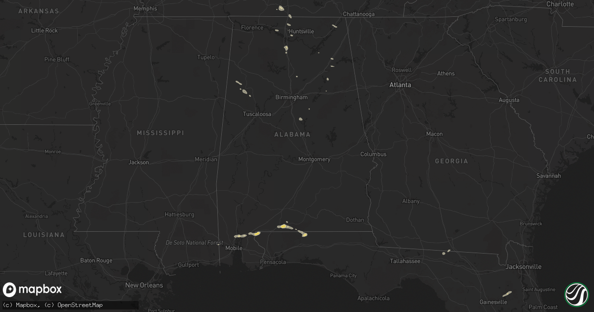
Hail Map in Alabama on July 1, 2015
Get this storm
July 1 map
$229
one time, instant access
Download today. No call, no setup
Keep the $229
Bought the map and want the full workflow? Apply the entire $229 to a subscription within 7 days. None of it is wasted.
Every map, not just this one
This buys you this map. Subscription and you get every map we run, in the markets you choose from a few cities to whole states to nationwide. Plus real-time alerts the moment a storm fires.
Contact data
Name, contact info, occupancy, even credit band for addresses in the footprint. You go from where it hit to who to call.
Become the source they trust
Unlimited branding weather history reports on demand. You already have the documented answer ready for the property owner, and you are the one who showed up with it.
Property data and RoofTrace estimates
Pull up any address you have got, its value and the exact code rules for that jurisdiction, straight from One Click Code. Then RoofTrace estimates the squares, pitch, and roof value, priced the way you price.
Storm reports in Alabama
Alabama
| Date | Description |
|---|---|
| 07/01/20153:48 PM CDT | Trees down on hwy 431 at wellington rd |
| 07/01/20152:54 PM CDT | Tree down on deams ferry rd |
| 07/01/20152:45 PM CDT | Tree down on i59 near mm198 |
| 07/01/20152:24 PM CDT | A few trees down across the county on coutny hwy 1...county hwy 15...370 poplar tr. Spotter estimated winds gust to 40mph |
| 07/01/20152:15 PM CDT | Trees down on leeth gap rd |
| 07/01/20152:00 PM CDT | Trees down blocking antioch rd. |
| 07/01/201512:57 AM CDT | Quarter sized hail reported in hollywood. Relayed via social media. |
All States Impacted by Hail Map on July 1, 2015
Cities Impacted by Hail Map on July 1, 2015
- Lambert, MT
- Circle, MT
- Grand Canyon, AZ
- Otter, MT
- Smithwick, SD
- Chadron, NE
- Hot Springs, SD
- Hay Springs, NE
- Buffalo Gap, SD
- Pine Ridge, SD
- Oral, SD
- Oelrichs, SD
- Campbell, NE
- Thermopolis, WY
- Kenansville, FL
- Saint Cloud, FL
- Chamberlain, SD
- Oacoma, SD
- Gregory, SD
- Pukwana, SD
- Platte, SD
- Reliance, SD
- Concho, AZ
- Custer, SD
- Edgemont, SD
- Newcastle, WY
- Lame Deer, MT
- Ashland, MT
- Springerville, AZ
- Hillsboro, MO
- De Soto, MO
- Carter, MT
- Geyser, MT
- Geraldine, MT
- Loma, MT
- Fort Benton, MT
- Myakka City, FL
- Glenrock, WY
- Wing, AL
- Grovespring, MO
- Laurel Hill, FL
- Baker, FL
- Linden, TN
- Sugar Tree, TN
- Parsons, TN
- Ganado, AZ
- Pulaski, TN
- Rushville, NE
- Dickson, TN
- Flagstaff, AZ
- Minden, NE
- Norton, KS
- Oberlin, KS
- Clayton, KS
- Jennings, KS
- Norcatur, KS
- Heber, AZ
- Winslow, AZ
- Colorado City, AZ
- Osage, WY
- Upton, WY
- Clermont, FL
- Ashland, MO
- Wooldridge, MO
- Columbia, MO
- Jefferson City, MO
- Jamestown, MO
- Hartsburg, MO
- Centertown, MO
- Ohatchee, AL
- Gadsden, AL
- Okeechobee, FL
- Weston, WY
- Moorcroft, WY
- Gillette, WY
- Rozet, WY
- Butler, MO
- Sedalia, MO
- Green Ridge, MO
- Sedona, AZ
- Shawnee, WY
- Lost Springs, WY
- Dudley, GA
- Dexter, GA
- Paola, KS
- Pleasanton, KS
- Mound City, KS
- Prescott, KS
- Fontana, KS
- Parker, KS
- Centerville, KS
- Osawatomie, KS
- La Cygne, KS
- Blue Mound, KS
- Louisburg, KS
- Saint Louis, MO
- Maryland Heights, MO
- Saint Ann, MO
- Bridgeton, MO
- Musselshell, MT
- Bassett, NE
- Winnett, MT
- Elkland, MO
- Buffalo, MO
- Fayette, AL
- Berry, AL
- Wakita, OK
- Manchester, OK
- Lusk, WY
- Harrison, NE
- Douglas, WY
- Manville, WY
- Fort Myers, FL
- Parks, AZ
- Williams, AZ
- Dry Creek, LA
- Kaibeto, AZ
- Independence, MO
- Greenwood, MO
- Lees Summit, MO
- Kansas City, MO
- Winter Garden, FL
- Kissimmee, FL
- Davenport, FL
- Orlando, FL
- Bertrand, NE
- Braithwaite, LA
- Belle Chasse, LA
- Mora, MO
- Smithton, MO
- Sheldon, MO
- Jerico Springs, MO
- Richey, MT
- Bloomfield, MT
- Savage, MT
- Adrian, MO
- Westcliffe, CO
- Osceola, MO
- Lowry City, MO
- Quincy, MO
- Deepwater, MO
- Broken Bow, NE
- Comstock, NE
- Lebanon, MO
- Phillipsburg, MO
- Cuba, NM
- Clyo, GA
- Springfield, GA
- Warsaw, MO
- Lincoln, MO
- Indiantown, FL
- Festus, MO
- Twin City, GA
- Eva, TN
- Jemez Springs, NM
- Garrett, WY
- Roach, MO
- Camdenton, MO
- Dickens, NE
- Saint Elizabeth, MO
- Ulman, MO
- Dixon, MO
- Iberia, MO
- Tuscumbia, MO
- Marshfield, MO
- Bloomsdale, MO
- Soperton, GA
- Avon Park, FL
- Lobelville, TN
- Brewton, AL
- Curtis, NE
- Frazer, MT
- Larslan, MT
- Peerless, MT
- Sebring, FL
- Evansville, WY
- Casper, WY
- Vail, AZ
- Roy, MT
- Naples, FL
- Zuni, NM
- Hickman, KY
- Union City, TN
- Troy, TN
- Burwell, NE
- Drexel, MO
- Harrisonville, MO
- Archie, MO
- Saint Francis, KS
- Strafford, MO
- Rives, TN
- Chambers, AZ
- Caliente, NV
- Sonoita, AZ
- Nashua, MT
- Clever, MO
- Billings, MO
- Highlandville, MO
- Crane, MO
- Santa Fe, TN
- Primm Springs, TN
- Ekalaka, MT
- Oconto, NE
- Mason City, NE
- Busby, MT
- Cape Coral, FL
- Bay Minette, AL
- Frostproof, FL
- Roundup, MT
- Worden, MT
- Athens, AL
- Madison, AL
- Lower Brule, SD
- Kansas City, KS
- Lake Wales, FL
- Goodspring, TN
- Vernon, AL
- Sulligent, AL
- Bardwell, KY
- Cunningham, KY
- Kevil, KY
- Barlow, KY
- Wickliffe, KY
- Paducah, KY
- La Center, KY
- Melber, KY
- Brusett, MT
- Happy Jack, AZ
- McDavid, FL
- Greenville, FL
- Madison, FL
- Arthur, NE
- Sundance, WY
- Saraland, AL
- Axis, AL
- Creola, AL
- Holbrook, AZ
- Rockville, MO
- Schell City, MO
- Fence Lake, NM
- Wauchula, FL
- Fort Meade, FL
- Forsyth, MT
- Buffalo, WY
- Hardin, MT
- Crow Agency, MT
- Birney, MT
- Keystone Heights, FL
- Prospect, TN
- Braman, OK
- Blackwell, OK
- Ansley, NE
- Marion, KY
- Quemado, NM
- Rich Hill, MO
- Hume, MO
- Hinsdale, MT
- Alpine, AZ
- Hollywood, AL
- Stevenson, AL
- Jordan, MT
- Pleasant Hill, MO
- Raymore, MO
- Kaiser, MO
- Osage Beach, MO
- El Dorado Springs, MO
- Trenton, TN
- Dyer, TN
- Statesboro, GA
- New Bloomfield, MO
- Anthony, KS
- Glasgow, MT
- Perry, GA
- California, MO
- Russellville, MO
- Stockton, MO
- Lincoln, AL
- Eastaboga, AL
- Western Grove, AR
- Saint Joe, AR
- Hasty, AR
- Counselor, NM
- La Jara, NM
- Regina, NM
- Wolf Point, MT
- Pinon, AZ
- Melrose, FL
- Waldo, FL
- Starke, FL
- Eagar, AZ
- Sand Springs, MT
- Vida, MT
- Harrold, SD
- Medford, OK
- Lehigh Acres, FL
- Lindrith, NM
- Freeman, MO
- Peculiar, MO
- Garden City, MO
- Grandview, MO
- Lone Jack, MO
- Albertville, AL
- Sargent, NE
- Pine Grove, LA
- Denham Springs, LA
- Greenwell Springs, LA
- Clinton, LA
- Greensburg, LA
- Volborg, MT
- Haines City, FL
- Walker, MO
- Nevada, MO
- Buffalo, SD
- Hopkinsville, KY
- Freeburg, IL
- Mascoutah, IL
- New Athens, IL
- Lohman, MO
- Harrisburg, MO
- Fayette, MO
- Chinook, MT
- Trafford, AL
- Hartville, MO
- Milo, MO
- Lance Creek, WY
- Westerville, NE
- Harlem, MT
- Hays, MT
- Rockledge, GA
- Sikeston, MO
- Bertrand, MO
- Montreal, MO
- Linn Creek, MO
- Hohenwald, TN
- Leslie, MO
- Sullivan, MO
- Adrian, GA
- Sarasota, FL
- Zolfo Springs, FL
- Polacca, AZ
- Bonita Springs, FL
- Richland, MT
- French Village, MO
- Hartselle, AL
- Clewiston, FL
- Aragon, NM
- Carterville, IL
- Columbia, TN
- Weaubleau, MO
- Dresden, TN
- Sharon, TN
- Valdosta, GA
- Pinetta, FL
- Florissant, CO
- Upland, NE
- Burke, SD
- Earth City, MO
- Saint Charles, MO
- East Saint Louis, IL
- Andalusia, AL
- Calhoun, MO
- Richards, MO
- Kennebec, SD
- Columbiana, AL
- Shelby, AL
- Martin, TN
- Rawlins, WY
- Lenzburg, IL
- Marissa, IL
- Belleville, IL
- Eldridge, MO
- Glendive, MT
- Tarrytown, GA
- Bon Aqua, TN
- Lyles, TN
- Loxahatchee, FL
- Keams Canyon, AZ
- Montrose, GA
- Cochran, GA
- Chester, GA
- Eugene, MO
- Eldon, MO
- Henley, MO
- Reeds Spring, MO
- Branson, MO
- Gallina, NM
- Ionia, MO
- Wheatland, MO
- Windsor, MO
- Edwards, MO
- Clinton, MO
- Cole Camp, MO
- Smithton, IL
- Millstadt, IL
- Freeburg, MO
- Koeltztown, MO
- Ponca City, OK
- Arcadia, FL
- Spring Hill, TN
- Estero, FL
- Ochopee, FL
- Kanab, UT
- McKenzie, TN
- Waynesville, MO
- Richland, MO
- Metropolis, IL
- Ledger, MT
- Whiteman Air Force Base, MO
- Knob Noster, MO
- Dadeville, MO
- Brooksville, FL
- Meta, MO
- Boaz, KY
- Snowflake, AZ
- Chester, MT
- Greenfield, MO
- Wilsonville, NE
- Holladay, TN
- Westport, TN
- Collinsville, AL
- Barnett, MO
- Latham, MO
- Rocheport, MO
- Fulton, MO
- Gainesville, MO
- Lewisburg, TN
- Sumner, NE
- Taylor, NE
- Brinktown, MO
- Pagosa Springs, CO
- Hickory, MS
- Wright, WY
- Riceville, TN
- Athens, TN
- Toney, AL
- Guffey, CO
- Hotevilla, AZ
- Pride, LA
- Oran, MO
- Benton, MO
- Blue Eye, MO
- Waverly, TN
- Nashville, TN
- Stoutland, MO
- Metter, GA
- Greenfield, TN
- Falkville, AL
- Oglala, SD
- Brentwood, TN
- Lucedale, MS
- Argyle, MO
- Montrose, MO
- New Orleans, LA
- Meraux, LA
- Chalmette, LA
- Ardmore, AL
- Ardmore, TN
- New Leipzig, ND
- Pinehill, NM
- Harpersville, AL
- Baton Rouge, LA
- Crocker, MO
- McEwen, TN
- Woodbury, GA
- Lake Park, GA
- Rosiclare, IL
- Long Lane, MO
- Fair Grove, MO
- Huntsville, AL
- Sweet Springs, MO
- Bonne Terre, MO
- Walnut Grove, MO
- Appleton City, MO
- Patagonia, AZ
- Second Mesa, AZ
- Brumley, MO
- Holts Summit, MO
- Ismay, MT
- Plevna, MT
- Kaycee, WY
- Conrad, MT
- Brady, MT
- Custer, MT
- Broadus, MT
- Recluse, WY


