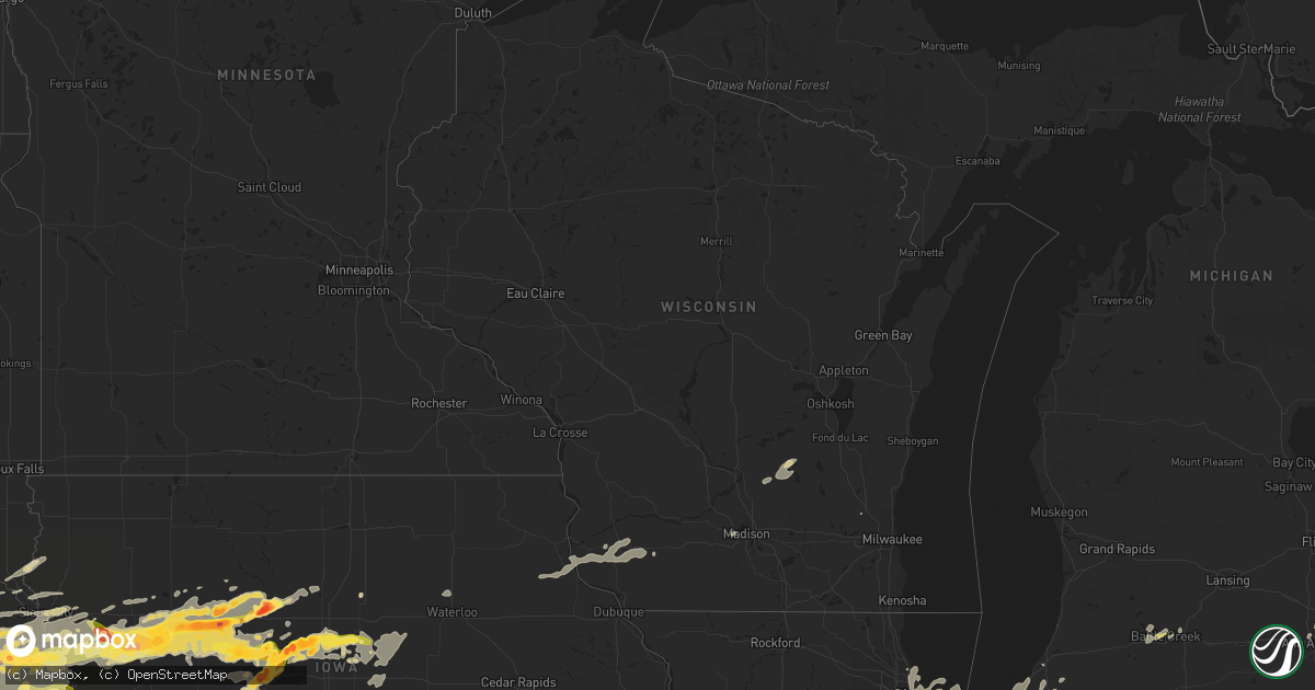
Hail Map in Wisconsin on June 30, 2014
Get this storm
June 30 map
$229
one time, instant access
Download today. No call, no setup
Keep the $229
Bought the map and want the full workflow? Apply the entire $229 to a subscription within 7 days. None of it is wasted.
Every map, not just this one
This buys you this map. Subscription and you get every map we run, in the markets you choose from a few cities to whole states to nationwide. Plus real-time alerts the moment a storm fires.
Contact data
Name, contact info, occupancy, even credit band for addresses in the footprint. You go from where it hit to who to call.
Become the source they trust
Unlimited branding weather history reports on demand. You already have the documented answer ready for the property owner, and you are the one who showed up with it.
Property data and RoofTrace estimates
Pull up any address you have got, its value and the exact code rules for that jurisdiction, straight from One Click Code. Then RoofTrace estimates the squares, pitch, and roof value, priced the way you price.
Storm reports in Wisconsin
Wisconsin
| Date | Description |
|---|---|
| 06/30/20146:25 PM CDT | Many trees in roadways. Shopko garden center damaged. |
| 06/30/20146:25 PM CDT | A couple trees and powerlines down. |
| 06/30/20146:25 PM CDT | Wind gust measured at home weather station. Trees snapped and uprooted. Widespread power outages. |
| 06/30/20146:20 PM CDT | Wind snapped a large tree in half and came through the roof and ceiling of residence on the north side of college ave. Exact location is college ave just west of howell |
| 06/30/20146:17 PM CDT | Multiple trees down. |
| 06/30/20146:15 PM CDT | 16 inch diameter tree knocked onto highway 145 near bonnie lane. |
| 06/30/20146:10 PM CDT | 2 foot diameter tree uprooted and fallen on a vehicle and completely blocking southbound 60th st. Exact location is 60th and morgan. |
| 06/30/20146:05 PM CDT | Major tree damage. Large trees and powerlines were downed. |
| 06/30/20146:03 PM CDT | Location is 1.3 miles north of waukesha. |
| 06/30/20146:00 PM CDT | Multiple reports of trees down in the city of waukesha. Some roads are blocked by fallen trees. |
| 06/30/20145:58 PM CDT | Location is 0.2 miles se of delavan. 18 inch diameter tree down. |
| 06/30/20145:55 PM CDT | 1 power pole blown down in town of concord. Time of event estimated from weather radar. Report via social media. |
| 06/30/20145:47 PM CDT | Location is 0.2 mi se of delavan. 12 inch diameter tree down over road. Exact location is south 6th and washington st. |
| 06/30/20145:40 PM CDT | 6 inch diameter tree branches down. |
| 06/30/20145:38 PM CDT | 15 inch diameter tree down. |
| 06/30/20145:37 PM CDT | Multiple large trees down. |
| 06/30/20145:33 PM CDT | A local report indicates 60 MPH wind near 2 WSW DELAVAN |
| 06/30/20145:33 PM CDT | 24 inch diameter tree down. |
| 06/30/20145:15 PM CDT | Large tree over road on north oakhill near washington elementary school |
| 06/30/20144:55 PM CDT | Multiple trees down and fields of corn flattened. |
| 06/30/20144:50 PM CDT | Trees down from livingston in grant county to dodgeville. |
| 06/30/20144:34 PM CDT | Electrical poles down in mineral point. |
| 06/30/20144:27 PM CDT | 5-6 power polls snapped in half... Trees damaged... Small aluminum shed destroyed. |
| 06/30/20144:20 PM CDT | Barn destroyed. |
| 06/30/20144:11 PM CDT | A local report indicates 70 MPH wind near LIVINGSTON |
| 06/30/20144:00 PM CDT | A local report indicates 78 MPH wind near 2 N LANCASTER |
| 06/30/20144:00 PM CDT | Approx. 24 ft x 80 ft pole shed with concrete walls-roof and wooden poles blown 200-300 yards into a field. Concrete walls are all that remain. Silo and power pole near |
| 06/30/20143:50 PM CDT | 60-70 mph estimated wind gusts. Tree branches and limbs flying. Some trees down nearby. |
| 06/30/20143:49 PM CDT | Trees down |
| 06/29/20147:15 PM CDT | Trees and power lines down with widespread power outages. Home weather station indicated 72 mph at onset of storm immediately taking multiple trees down and wires. |
All States Impacted by Hail Map on June 30, 2014
Cities Impacted by Hail Map on June 30, 2014
- Jolley, IA
- Pomeroy, IA
- Manson, IA
- Humboldt, IA
- Rockwell City, IA
- Clare, IA
- Panama, IA
- Hutchinson, KS
- Partridge, KS
- Nickerson, KS
- Iowa Falls, IA
- Shamrock, TX
- Goodwell, OK
- Kirksville, MO
- Novinger, MO
- Greentop, MO
- Fort Dodge, IA
- Guthrie Center, IA
- Fort Stockton, TX
- Neola, IA
- Underwood, IA
- Pierce, NE
- Wayne, NE
- Carroll, NE
- Hoskins, NE
- Mclean, TX
- Sloan, IA
- Whiting, IA
- Fort Davis, TX
- Monrovia, IN
- Stilesville, IN
- Martinsville, IN
- Des Moines, IA
- Hartford, IA
- Ackworth, IA
- Carlisle, IA
- Indianola, IA
- Pleasantville, IA
- Norwalk, IA
- Milo, IA
- Swan, IA
- Runnells, IA
- Logan, IA
- Persia, IA
- Harlan, IA
- Portsmouth, IA
- Blair, NE
- Herman, NE
- Ogden, IA
- Wall Lake, IA
- Battle Creek, IA
- Breda, IA
- Jewell, IA
- Scranton, IA
- Farnhamville, IA
- Harcourt, IA
- Paton, IA
- Dana, IA
- Danbury, IA
- Correctionville, IA
- Glidden, IA
- Ellsworth, IA
- Hornick, IA
- Carroll, IA
- Lytton, IA
- Kiron, IA
- Rodney, IA
- Radcliffe, IA
- Smithland, IA
- Lake View, IA
- Castana, IA
- Anthon, IA
- Ute, IA
- Schaller, IA
- Beaver, IA
- Pilot Mound, IA
- Ida Grove, IA
- Rippey, IA
- Story City, IA
- Sac City, IA
- Odebolt, IA
- Nemaha, IA
- McCallsburg, IA
- Jefferson, IA
- Lake City, IA
- Denison, IA
- Hubbard, IA
- Schleswig, IA
- Galva, IA
- Gowrie, IA
- Stanhope, IA
- Boone, IA
- Boxholm, IA
- Garden City, IA
- Grand Junction, IA
- Auburn, IA
- Mapleton, IA
- Fonda, IA
- Randall, IA
- Churdan, IA
- Oto, IA
- Charter Oak, IA
- Stratford, IA
- Somers, IA
- Vail, IA
- Dayton, IA
- Early, IA
- Arthur, IA
- Lohrville, IA
- Pampa, TX
- Coon Rapids, IA
- Moorland, IA
- Badger, IA
- Springfield, CO
- Orient, IA
- Greenfield, IA
- Exira, IA
- Audubon, IA
- Hamlin, IA
- Vincent, IA
- Duncombe, IA
- Cumming, IA
- Arlington, KS
- Turon, KS
- Peabody, KS
- Walton, KS
- Plains, KS
- Menlo, IA
- Adair, IA
- Anita, IA
- Casey, IA
- Texhoma, OK
- Loraine, IL
- Mendon, IL
- West Point, IL
- Mobeetie, TX
- Battle Creek, MI
- Centerville, KS
- Parker, KS
- Chesterton, IN
- Morton, TX
- Fontanelle, IA
- Climax Springs, MO
- La Porte, IN
- New Carlisle, IN
- Rolling Prairie, IN
- Richmond, MO
- Campo, CO
- West Point, NE
- Bancroft, NE
- Benton Harbor, MI
- Green City, MO
- Worthington, MO
- Green Castle, MO
- Adel, IA
- Dexter, IA
- Minden, IA
- Earlham, IA
- Elk Horn, IA
- Marne, IA
- Walnut, IA
- Van Meter, IA
- Stuart, IA
- De Soto, IA
- Brayton, IA
- Waukee, IA
- Redfield, IA
- Shelby, IA
- Hancock, IA
- Atlantic, IA
- Avoca, IA
- Denver, MO
- Blythedale, MO
- Milan, MO
- Harris, MO
- Unionville, MO
- Albany, MO
- Martinsville, MO
- Newtown, MO
- Cainsville, MO
- Ridgeway, MO
- Bethany, MO
- Gentry, MO
- Pollock, MO
- Queen City, MO
- Eagleville, MO
- Baring, MO
- Downing, MO
- Princeton, MO
- Worth, MO
- Brashear, MO
- Lucerne, MO
- Independence, MO
- Blue Springs, MO
- Liberty, MO
- Camden Point, MO
- Dearborn, MO
- Platte City, MO
- Kearney, MO
- Smithville, MO
- Holt, MO
- Trimble, MO
- Lathrop, MO
- Plattsburg, MO
- Gower, MO
- Edgerton, MO
- Defiance, IA
- Kirkman, IA
- Westphalia, IA
- Earling, IA
- Paxton, IL
- Ludlow, IL
- Brewster, NE
- Winslow, NE
- Arlington, NE
- Hooper, NE
- Sioux City, IA
- Lawton, IA
- Akron, IA
- Bennington, NE
- Omaha, NE
- Fort Calhoun, NE
- Crescent, IA
- Waldron, MO
- Farley, MO
- Bates City, MO
- Kansas City, MO
- Grain Valley, MO
- Kansas City, KS
- Orrick, MO
- Sibley, MO
- Kingsville, MO
- Holden, MO
- Oak Grove, MO
- Leavenworth, KS
- Buckner, MO
- Riverside, MO
- Lees Summit, MO
- Pleasant Hill, MO
- Lansing, KS
- Lone Jack, MO
- Centerview, MO
- Greenwood, MO
- Woodbine, IA
- Dunlap, IA
- Irwin, IA
- Kimballton, IA
- Cushing, IA
- Plainview, NE
- Winside, NE
- Wisner, NE
- Lyons, NE
- Salix, IA
- Macy, NE
- Lanesboro, IA
- Onawa, IA
- Climbing Hill, IA
- Westside, IA
- Laurel, NE
- Palmer, IA
- Hubbard, NE
- Jamaica, IA
- New Providence, IA
- Rosalie, NE
- Bagley, IA
- Sergeant Bluff, IA
- Decatur, NE
- Osmond, NE
- Concord, NE
- Beemer, NE
- Walthill, NE
- Mclean, NE
- Ricketts, IA
- Randolph, NE
- Norfolk, NE
- Pender, NE
- Homer, NE
- Wakefield, NE
- Moville, IA
- Eagle Grove, IA
- Barnum, IA
- Thurston, NE
- Waterbury, NE
- Bronson, IA
- Emerson, NE
- Winnebago, NE
- Allen, NE
- Kahoka, MO
- Luray, MO
- Brazil, IN
- Greenfield, IL
- Ford, KS
- Minneola, KS
- Liberal, KS
- Macon, GA
- Lizella, GA
- Humansville, MO
- Weaubleau, MO
- Madison, NE
- Stanton, NE
- Stratford, TX
- Terre Haute, IN
- Rosedale, IN
- Conway Springs, KS
- Davis City, IA
- Lamoni, IA
- Atkinson, NE
- Amelia, NE
- Burwell, NE
- San Jon, NM
- Centerville, IA
- Moulton, IA
- Clinton, IN
- Paris, IL
- Chrisman, IL
- Pleasant Hill, IA
- Gilmore City, IA
- Gate, OK
- Laverne, OK
- Clayton, IN
- Coatesville, IN
- Missouri Valley, IA
- Howells, NE
- Pilger, NE
- Oneill, NE
- Kim, CO
- Fayette, OH
- West Unity, OH
- Orchard, NE
- Page, NE
- La Cygne, KS
- Storm Lake, IA
- Moundridge, KS
- Newton, KS
- Hesston, KS
- Hugoton, KS
- Villa Grove, IL
- Livingston, WI
- Guttenberg, IA
- Glen Haven, WI
- Elkader, IA
- Fennimore, WI
- Montfort, WI
- Strawberry Point, IA
- Bloomington, WI
- Garnavillo, IA
- Edgewood, IA
- Prairie Du Chien, WI
- Bagley, WI
- Stitzer, WI
- Lancaster, WI
- Garber, IA
- Elkport, IA
- Wyaconda, MO
- Royal, NE
- Brunswick, NE
- Abbyville, KS
- Arbela, MO
- Memphis, MO
- Tatum, NM
- Gruver, TX
- Sunray, TX
- Bassett, NE
- Zearing, IA
- Guymon, OK
- Ainsworth, NE
- Lincoln, MO
- Ionia, MO
- Cole Camp, MO
- Valparaiso, IN
- Rea, MO
- Rosendale, MO
- Bolckow, MO
- South Bend, IN
- Burrton, KS
- Halstead, KS
- Moorhead, IA
- Pisgah, IA
- Longview, IL
- Philo, IL
- Grundy Center, IA
- Tilden, NE
- Battle Creek, NE
- Meadow Grove, NE
- New Troy, MI
- Michigan City, IN
- Stevensville, MI
- New Buffalo, MI
- Lakeside, MI
- Sawyer, MI
- Bridgman, MI
- Harbert, MI
- Buchanan, MI
- Union Pier, MI
- Galien, MI
- Three Oaks, MI
- Keyes, OK
- Boise City, OK
- Walsh, CO
- Rolla, KS
- Elkhart, KS
- Waterloo, IA
- Janesville, IA
- Denver, IA
- Cedar Falls, IA
- Melbourne, IA
- State Center, IA
- Marshalltown, IA
- Dalhart, TX
- Universal, IN
- Tekamah, NE
- Craig, NE
- Oakland, NE
- West Des Moines, IA
- Mokane, MO
- New Bloomfield, MO
- Fulton, MO
- Westfield, IA
- Hinton, IA
- Jefferson, SD
- Jacksonville, AL
- Piedmont, AL
- Elkland, MO
- Polk, MO
- Bolivar, MO
- Berrien Springs, MI
- Morse, TX
- Lacona, IA
- Augusta, MI
- Climax, MI
- Galesburg, MI
- Edgar Springs, MO
- Manilla, IA
- Windsor Heights, IA
- Patterson, IA
- Grimes, IA
- Linden, IA
- Modale, IA
- Manning, IA
- Prole, IA
- Valley, NE
- Dallas Center, IA
- Saint Charles, IA
- Martensdale, IA
- Scribner, NE
- Bridgewater, IA
- Clive, IA
- Panora, IA
- Mondamin, IA
- Elkhorn, NE
- Monroe, IA
- Urbandale, IA
- Massena, IA
- Knoxville, IA
- Kennard, NE
- Otley, IA
- Honey Creek, IA
- Magnolia, IA
- Oakland, IA
- Bevington, IA
- Winterset, IA
- Wiota, IA
- Minburn, IA
- Prairie City, IA
- Washington, NE
- Grant Park, IL
- Momence, IL
- Bourbonnais, IL
- Kankakee, IL
- Bartlett, NE
- Chambers, NE
- Ames, IA
- Leigh, NE
- Albion, IA
- Clarion, IA
- Beaman, IA
- Stuart, NE
- Saint Anthony, IA
- Lehigh, IA
- Clemons, IA
- Oakdale, NE
- Ewing, NE
- South Sioux City, NE
- Pierson, IA
- Newell, IA
- Callender, IA
- Elgin, NE
- Clarkson, NE
- Winnetoon, NE
- Jackson, NE
- Perry, IA
- Deloit, IA
- Clearwater, NE
- Nevada, IA
- Neligh, NE
- Holstein, IA
- Whitten, IA
- Eldora, IA
- Arcadia, IA
- Purdum, NE
- Dawson, IA
- North Sioux City, SD
- Roland, IA
- Union, IA
- Dakota City, NE
- Conrad, IA
- Webster City, IA
- Liscomb, IA
- Ponca, NE
- Creighton, NE
- Woolstock, IA
- Dodge, NE
- Taylor, NE
- Gadsden, AL
- Derby, KS
- Rose Hill, KS
- Andover, KS
- Wichita, KS
- Lenexa, KS
- Overland Park, KS
- Miami, TX
- Osceola, MO
- Harwood, MO
- El Dorado Springs, MO
- Skokie, IL
- Wilmette, IL
- Glenview, IL
- Pella, IA
- Sylvia, KS
- Plevna, KS
- Little Sioux, IA
- Holts Summit, MO
- Chicago, IL
- Pretty Prairie, KS
- Newton, IA
- Stover, MO
- Tolono, IL
- Bouton, IA
- Madrid, IA
- Woodward, IA
- Granger, IA
- Eads, CO
- Haswell, CO
- Macks Creek, MO
- Roach, MO
- Potomac, IL
- Penfield, IL
- Treynor, IA
- Council Bluffs, IA
- Tucumcari, NM
- Springfield, IL
- Columbia, IA
- Melcher Dallas, IA
- Elk Point, SD
- Burbank, SD
- Ireton, IA
- Rockville, IN
- Saint Joseph, MO
- Newcastle, NE
- Berrien Center, MI
- Dowagiac, MI
- Eau Claire, MI
- Griffith, IN
- Dyer, IN
- Schererville, IN
- Cedar Lake, IN
- Merrillville, IN
- Crete, IL
- Saint John, IN
- Crown Point, IN
- Monticello, IL
- Le Roy, KS
- New Virginia, IA
- Osceola, IA
- North Newton, KS
- Fox Lake, WI
- Randolph, WI
- Dixon, NE
- Hartington, NE
- Coleridge, NE
- Belden, NE
- Manteno, IL
- Eldon, MO
- Tuscumbia, MO
- Eugene, MO
- Flemington, MO
- St John, KS
- Macksville, KS
- Marshall, MI
- Bellevue, MI
- Booneville, IA
- Lawson, MO
- Rayville, MO
- Polo, MO
- Beaver Dam, WI
- Pesotum, IL
- Sadorus, IL
- Tebbetts, MO
- Union Star, MO
- Savannah, MO
- Beecher, IL
- Lowell, IN
- La Plata, MO
- Steedman, MO
- Poland, IN
- Bowling Green, IN
- Hebron, IN
- Knox City, MO
- Edina, MO
- Dodge City, KS
- Cisco, IL
- Niles, MI
- Hatfield, MO
- Tuscola, IL
- Garnett, KS
- Blue Mound, KS
- Greeley, KS
- Kincaid, KS
- Welda, KS
- Mound City, KS
- Cunningham, KS
- Sawyer, KS
- Coats, KS
- Pratt, KS
- Ann Arbor, MI
- South Lyon, MI
- Walker, MO
- Schell City, MO
- Karval, CO
- Colfax, IA
- Lewis, IA
- Mentone, TX
- Reelsville, IN
- Urbana, MO
- Louisburg, MO
- Granada, CO
- Excelsior Springs, MO
- Bonner Springs, KS
- Shawnee, KS
- Middleton, WI
- Madison, WI
- Camp Point, IL
- Golden, IL
- Greenville, FL
- Kaiser, MO
- Brumley, MO
- Perryton, TX
- Ravenwood, MO
- Parnell, MO
- Maryville, MO
- Sheridan, MO
- Pickering, MO
- Kismet, KS
- Hooker, OK
- Otho, IA
- Mulvane, KS
- Mount Hope, WI
- Lake Station, IN
- Portage, IN
- Gary, IN
- Weldon, IA
- Mount Ayr, IA
- Redding, IA
- Grant City, MO
- Bonfield, IL
- Easton, MO
- Stewartsville, MO
- Newburg, MO
- Bradford, IA
- Hampton, IA
- Bloomfield, IA
- Hardin, MO
- Henrietta, MO
- Camden, MO
- Argonia, KS
- Linden, WI
- Augusta, KS
- Hurdland, MO
- Munford, AL
- Dennison, IL
- West Terre Haute, IN
- Goddard, KS
- Palmetto, FL
- Bradenton, FL
- Washta, IA
- Adrian, MO
- Rutledge, MO
- Gorin, MO
- La Belle, MO
- Stafford, KS
- Wellington, TX
- Harmony, IN
- Carbon, IN
- Oxford, AL
- Anniston, AL
- Carrollton, MO
- Norborne, MO
- Pocahontas, IA
- Monticello, FL
- Carthage, IL
- Hamilton, IL
- Atlanta, KS
- Douglass, KS
- Leon, KS
- Alpine, TX
- Galt, IA
- Buhler, KS
- Cowgill, MO
- Mcconnell Afb, KS
- Argyle, IA
- Revere, MO
- Wayland, MO
- Lamar, MO
- Knob Noster, MO
- Nauvoo, IL
- Keokuk, IA
- Montrose, IA
- Fall River, WI
- Rio, WI
- Cambria, WI
- Emmet, NE
- Florence, KS
- East Chicago, IN
- Hammond, IN
- Wellington, MO
- Haven, KS
- Chanute, KS
- Warsaw, MO
- Lucas, IA
- Quimby, IA
- Aurelia, IA
- Yale, IA
- Arcola, IL
- Champaign, IL
- Bayard, IA
- Monee, IL
- University Park, IL
- Park Forest, IL
- Richton Park, IL
- Peotone, IL
- Chicago Heights, IL
- Steger, IL
- Knightsville, IN
- Hillsdale, IN
- Montezuma, IN
- New Hampton, MO
- Spencer, IN
- Spearman, TX
- Lincolnwood, IL
- Evanston, IL
- Alta, IA
- Centertown, MO
- Williamstown, MO
- Plains, TX
- Hubertus, WI
- Colgate, WI
- Blencoe, IA
- Knierim, IA


