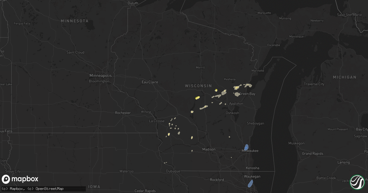
Hail Map in Wisconsin on June 29, 2025
Get this storm
June 29 map
$229
one time, instant access
Download today. No call, no setup
Keep the $229
Bought the map and want the full workflow? Apply the entire $229 to a subscription within 7 days. None of it is wasted.
Every map, not just this one
This buys you this map. Subscription and you get every map we run, in the markets you choose from a few cities to whole states to nationwide. Plus real-time alerts the moment a storm fires.
Contact data
Name, contact info, occupancy, even credit band for addresses in the footprint. You go from where it hit to who to call.
Become the source they trust
Unlimited branding weather history reports on demand. You already have the documented answer ready for the property owner, and you are the one who showed up with it.
Property data and RoofTrace estimates
Pull up any address you have got, its value and the exact code rules for that jurisdiction, straight from One Click Code. Then RoofTrace estimates the squares, pitch, and roof value, priced the way you price.
Storm reports in Wisconsin
Wisconsin
| Date | Description |
|---|---|
| 06/29/20253:20 PM CDT | Powerlines down. |
| 06/29/20253:18 PM CDT | Wind damage to power transformer causing the power to be knocked out. Blown transformer seen on video via social media. |
| 06/29/20252:46 PM CDT | Uprooted tree. Time estimated by radar. |
| 06/29/20251:48 PM CDT | Damaging wind gust snapped a large maple tree onto a shed. |
| 06/29/20251:42 PM CDT | Estimated 50 to 60 mph wind gusts. |
| 06/29/20251:34 PM CDT | Corrects previous tstm wnd dmg report from scandinavia. Several trees down. Time estimated from radar. |
| 06/29/20251:27 PM CDT | Time estimated by radar. |
| 06/29/20251:11 PM CDT | Several trees down. Time estimated from radar. |
| 06/29/20251:09 PM CDT | Relayed via wsaw-tv. |
| 06/29/20251:00 PM CDT | Report via social media. |
| 06/28/20259:23 PM CDT | Milwaukee fire department reports that an empty plane was flipped from thunderstorm wind gusts at milwaukee lawrence-timmerman a |
| 06/28/20259:23 PM CDT | Milwaukee fire department reports that an empty plane was flipped from thunderstorm wind gusts at milwaukee lawrence-timmerman airport. |
| 06/28/20259:20 PM CDT | Off-duty nws employee reports large tree and branch down near silver spring drive and interstate 41. |
| 06/28/20258:49 PM CDT | Broadcast media relays report of tree down near 97th and carmen near butler. |
| 06/28/20258:44 PM CDT | Photo shared on social media of large tree trunk split near 106th and congress in northern wauwautosa. |
| 06/28/20257:26 PM CDT | Awos station kmwc milwaukee lawrence-timmerman airport. |
| 06/28/20257:26 PM CDT | Tree down relayed from social media. Time estimated from radar. |
All States Impacted by Hail Map on June 29, 2025
Cities Impacted by Hail Map on June 29, 2025
- Custer, SD
- Columbia, PA
- Mount Joy, PA
- Mountville, PA
- Lancaster, PA
- Burchard, NE
- Baileyville, KS
- Steinauer, NE
- Hiawatha, KS
- Robinson, KS
- Horton, KS
- Troy, KS
- Pawnee City, NE
- Hermosa, SD
- Fairburn, SD
- Odell, NE
- Diller, NE
- Falls City, NE
- Villisca, IA
- Nodaway, IA
- New Market, IA
- Bedford, IA
- Blockton, IA
- Gravity, IA
- Sharpsburg, IA
- Grant City, MO
- Sheridan, MO
- Dearborn, MO
- Gilman City, MO
- Agency, MO
- Aurora, KS
- Concordia, KS
- Clyde, KS
- Faucett, MO
- De Kalb, MO
- Saint Joseph, MO
- Spickard, MO
- Clifton, KS
- Morganville, KS
- Clay Center, KS
- Topeka, KS
- Auburn, KS
- Tecumseh, KS
- Wakarusa, KS
- Berryton, KS
- Lecompton, KS
- Lawrence, KS
- Elmer, MO
- La Plata, MO
- New Boston, MO
- Ethel, MO
- Eudora, KS
- Kirksville, MO
- Centre, AL
- Le Roy, KS
- Burlington, KS
- Waverly, KS
- Westphalia, KS
- Wisconsin Rapids, WI
- Mound City, KS
- Iola, WI
- Blue Mound, KS
- Mapleton, KS
- Amherst, WI
- Iola, KS
- Clintonville, WI
- Bear Creek, WI
- Arkdale, WI
- Necedah, WI
- Pulaski, WI
- Bonduel, WI
- Scandinavia, WI
- Waupaca, WI
- Prescott, KS
- Marion, WI
- Tigerton, WI
- Toronto, KS
- Hancock, WI
- Brimson, MN
- Pleasanton, KS
- Fulton, KS
- Two Harbors, MN
- Norwalk, WI
- Fort Scott, KS
- Ogdensburg, WI
- Manawa, WI
- Caledonia, MN
- Yates Center, KS
- Redfield, KS
- Plainfield, WI
- Hume, MO
- Richards, MO
- Newcastle, WY
- Humboldt, KS
- Chanute, KS
- Piqua, KS
- New London, WI
- Benedict, KS
- Buffalo, KS
- Shiocton, WI
- Krakow, WI
- Marathon, TX
- Almond, WI
- Nevada, MO
- Sobieski, WI
- Ochopee, FL
- Pueblo, CO
- Black Creek, WI
- Hill City, SD
- Larsen, WI
- Fremont, WI
- Sparta, WI
- Soldiers Grove, WI
- Readstown, WI
- Sibley, IL
- Strawn, IL
- Forrest, IL
- Abrams, WI
- Seymour, WI
- Cashton, WI
- Westby, WI
- Weyauwega, WI
- Little Suamico, WI
- Lamar, MO
- Viroqua, WI
- Granite Canon, WY
- Waukon, IA
- Cheyenne, WY
- Harpersville, AL
- Fort Stockton, TX
- Columbiana, AL
- Bellvue, CO
- Ontario, WI
- Hillsboro, WI
- La Farge, WI
- Dorchester, IA
- Green Bay, WI
- Liberal, MO
- Wilsonville, AL
- Beulah, WY
- Spearfish, SD
- New Albin, IA
- Lockwood, MO
- Jerico Springs, MO
- Golden City, MO
- Whitewood, SD
- Drake, CO
- Glen Haven, CO
- Rosedale, MD
- Essex, MD
- Shelby, AL
- Middle River, MD
- Greenfield, MO
- Upton, WY
- Carr, CO
- Marion, AL
- Abernathy, TX
- Richland Center, WI
- Centreville, AL
- Everton, MO
- Baltimore, MD
- South Greenfield, MO
- Nunn, CO
- Pierce, CO
- Loveland, CO
- Caulfield, MO
- Dundalk, MD
- Palm City, FL
- Rockford, AL
- Kellyton, AL
- Granby, MO
- Walnut Grove, MO
- Ash Grove, MO
- Willard, MO
- Springfield, MO
- Strafford, MO
- Fair Grove, MO
- North Freedom, WI
- Loganville, WI
- Boston, GA
- Estes Park, CO
- Lyons, CO
- Clanton, AL
- Wellington, CO
- Bois D Arc, MO
- Mount Vernon, MO
- Crane, MO
- Spokane, MO
- Nixa, MO
- Marionville, MO
- Billings, MO
- Halltown, MO
- Republic, MO
- Highlandville, MO
- Reeds Spring, MO
- Aurora, MO
- Rogersville, MO
- Ponce De Leon, MO
- Galena, MO
- Brookline, MO
- Clever, MO
- Miller, MO
- Ozark, MO
- Fordland, MO
- Marshfield, MO
- Chestnutridge, MO
- Walnut Shade, MO
- Sparta, MO
- Ault, CO
- Meriden, WY
- Albin, WY
- Burns, WY
- Buffalo Gap, SD
- Pine Ridge, SD
- Trementina, NM
- Avondale, CO
- Fowler, CO
- Sparrows Point, MD
- Verbena, AL
- Hollister, MO
- Forsyth, MO
- Chadwick, MO
- Rockaway Beach, MO
- Cape Fair, MO
- Bruner, MO
- Oldfield, MO
- Branson, MO
- Bradleyville, MO
- Mansfield, MO
- Taneyville, MO
- Powersite, MO
- Hartville, MO
- Kirbyville, MO
- Seymour, MO
- Ava, MO
- Garrison, MO
- Berthoud, CO
- Briggsdale, CO
- Galeton, CO
- Edgemont, SD
- Edinburg, VA
- Wardensville, WV
- South West City, MO
- Noel, MO
- Ruckersville, VA
- Lagrange, WY
- Lubbock, TX
- Leroy, AL
- Ridgeway, WI
- Jackson, AL
- Juneau, WI
- Hawk Springs, WY
- Shallowater, TX
- Grenville, NM
- Folsom, NM
- Colorado Springs, CO
- Dupree, SD
- Anderson, MO
- Norwood, MO
- Theodosia, MO
- Protem, MO
- Macomb, MO
- Wasola, MO
- Squires, MO
- Noble, MO
- Cedarcreek, MO
- Zanoni, MO
- Mountain Grove, MO
- Thornfield, MO
- Gainesville, MO
- Isabella, MO
- Brixey, MO
- Kissee Mills, MO
- Drury, MO
- Rueter, MO
- Hardenville, MO
- Pontiac, MO
- Mountain Home, AR
- Oakland, AR
- Clarkridge, AR
- Yellville, AR
- Lakeview, AR
- Midway, AR
- Lead Hill, AR
- Peel, AR
- Omaha, AR
- Gassville, AR
- Cotter, AR
- Flippin, AR
- Bull Shoals, AR
- Pyatt, AR
- Harrison, AR
- Everton, AR
- Horicon, WI
- Egg Harbor Township, NJ
- Mays Landing, NJ
- Immokalee, FL
- Yoder, CO
- Tecumseh, MO
- Lyman, NE
- Harrisburg, NE
- Yoder, WY
- Batesland, SD
- Porcupine, SD
- Manderson, SD
- Wounded Knee, SD
- Hot Springs, SD
- Lance Creek, WY
- Boise City, OK
- Gering, NE
- Torrington, WY
- Kermit, TX
- Augusta, KS
- Glendo, WY
- Hartville, WY
- Wheatland, WY
- Veteran, WY
- Sardis, AL
- Kannapolis, NC
- Afton, OK
- Towanda, KS
- Piedmont, KS
- Eureka, KS
- El Dorado, KS
- Mitchell, NE
- Morrill, NE
- Scottsbluff, NE
- Valley Springs, AR
- Calico Rock, AR
- Norfork, AR
- Gilbert, AR
- Harriet, AR
- Marshall, AR
- Western Grove, AR
- Pindall, AR
- Saint Joe, AR
- Summit, AR
- Marble Falls, AR
- Hasty, AR
- Chelsea, OK
- Washington, GA
- Tignall, GA
- Rayle, GA
- Mulvane, KS
- Derby, KS
- Haysville, KS
- Nowata, OK
- Elkhart, KS
- Benton, KS
- Ontonagon, MI
- Ewen, MI
- Grove Hill, AL
- Huntersville, NC
- Agate, CO
- Gordon, NE
- Minatare, NE
- Lingle, WY
- Harrison, NE
- Jay Em, WY
- Severy, KS
- Douglass, KS
- Latham, KS
- Goodwell, OK
- Fort Morgan, CO
- Claremore, OK
- Vinita, OK
- Leon, KS
- Andover, KS
- Ramah, CO
- Oelrichs, SD
- Chadron, NE
- Whitney, NE
- Martin, SD
- Merriman, NE
- Howard, KS
- Marsland, NE
- Hemingford, NE
- Fall River, KS
- Moline, KS
- Elk Falls, KS
- Garrett, WY
- Columbia, VA
- Simla, CO
- Palmyra, WI
- Eagle, WI
- Deer Trail, CO
- Cassville, WI
- Farwell, TX
- Arlington Heights, IL
- Mount Prospect, IL
- Wheeling, IL
- Prospect Heights, IL
- Buffalo Grove, IL
- Deerfield, IL
- Lincolnshire, IL
- Des Plaines, IL
- Highland Park, IL
- Glenview, IL
- Northbrook, IL
- Keyes, OK
- Hanna, WY
- Longton, KS
- Bayard, NE
- Angora, NE
- Hay Springs, NE
- Alliance, NE
- Udall, KS
- Seneca, KS
- Beatrice, NE
- Malmo, NE
- Rose Hill, KS
- Guymon, OK
- Goochland, VA
- Atlanta, KS
- Grenola, KS
- Cambridge, KS
- Hoven, SD
- Lebanon, SD
- Gettysburg, SD
- Tolstoy, SD
- Java, SD
- Onaka, SD
- Bowdle, SD
- Roscoe, SD
- Faulkton, SD
- Seneca, SD
- Highmore, SD
- Orient, SD
- Onida, SD
- Cresbard, SD
- Ipswich, SD
- Northville, SD
- Redfield, SD
- Ashton, SD
- Rockham, SD
- Mansfield, SD
- Fort Laramie, WY
- Chugwater, WY
- Thayer, MO
- Whitman, NE
- Rushville, NE
- Rock, KS
- Winfield, KS
- Belle Plaine, KS
- Oxford, KS
- Burden, KS
- Arkansas City, KS
- Geuda Springs, KS
- Peru, KS
- Pawhuska, OK
- Chautauqua, KS
- Sedan, KS
- Cedar Vale, KS
- Dexter, KS
- Shidler, OK
- Newkirk, OK
- Maple City, KS
- Caney, KS
- Copan, OK
- Niotaze, KS
- Havana, KS
- Elk City, KS
- Limon, CO
- Texico, NM
- Dewey, OK
- Bartlesville, OK
- Wann, OK
- Delaware, OK
- Karval, CO
- Wild Horse, CO
- Kit Carson, CO
- Walsh, CO
- Hugo, CO
- Medicine Bow, WY
- Clovis, NM
- Haswell, CO
- Portales, NM
- Westport, SD
- Aberdeen, SD
- Mellette, SD
- Brentford, SD
- Warner, SD
- Hyannis, NE
- Ponca City, OK
- Burbank, OK
- Kaw City, OK
- Ochelata, OK
- Lenapah, OK
- Arriba, CO
- Stanardsville, VA
- Millersburg, MI
- Lakin, KS
- Wellington, KS
- Onaway, MI
- Woodford, VA
- Hawks, MI
- Guernsey, WY
- Johnson, KS
- Norwich, KS
- Argonia, KS
- Harper, KS
- Barnsdall, OK
- Fairfax, OK
- Wynona, OK
- Ralston, OK
- Ramona, OK
- Marland, OK
- Talala, OK
- Mullen, NE
- Douglas, WY
- Oologah, OK
- Milton, KS
- Buffalo Junction, VA
- Red Oak, VA
- Scottsburg, VA
- Danville, KS
- Caldwell, KS
- Mayfield, KS
- Cheyenne Wells, CO
- Arapahoe, CO
- Sharon Springs, KS
- San Jon, NM
- Milan, KS
- Collinsville, OK
- Pawnee, OK
- Skiatook, OK
- Hominy, OK
- Vera, OK
- Sperry, OK
- Osage, OK
- Prue, OK
- Crawford, NE
- Freeport, KS
- Lake Forest, IL
- Highwood, IL
- Bluff City, KS
- Elida, NM
- Milwaukee, WI
- Menomonee Falls, WI
- Brookfield, WI
- Butler, WI
- Elm Grove, WI
- Mequon, WI
- Tryon, NE
- Ellsworth, NE
- Braman, OK
- Weskan, KS
- Medford, OK
- Conway Springs, KS
- Channing, TX
- Nash, OK
- Adair, OK
- Whitewater, KS
- Stapleton, NE
- Peck, KS
- Newton, KS
- Tribune, KS
- Venango, NE
- Brule, NE
- Pryor, OK
- Catoosa, OK
- Wakita, OK
- Ogallala, NE
- Grant, NE
- Madrid, NE
- South Haven, KS
- Nardin, OK
- Lamont, OK
- Blackwell, OK
- Deer Creek, OK
- Carrier, OK
- Kremlin, OK
- Hunter, OK
- Tonkawa, OK
- Enid, OK
- Pond Creek, OK
- Red Rock, OK
- Covington, OK
- Billings, OK
- Garber, OK
- Fairmont, OK
- Perry, OK
- Wallace, KS
- Burlington, CO
- Fredonia, KS
- Inola, OK
- Oxford, NE
- Ford, VA
- Floyd, NM
- Oberlin, KS
- Danbury, NE
- Imperial, NE
- Wauneta, NE
- Elsie, NE
- Wallace, NE
- Clearwater, KS
- Kyle, SD
- Arcola, MO
- Pratt, KS
- S Coffeyville, OK
- Beaver City, NE
- Goodland, KS
- Burrton, KS
- Maxwell, NE
- North Platte, NE
- Arnold, NE
- Brady, NE
- Enders, NE
- Hayes Center, NE
- Halstead, KS
- Edison, NE
- Wichita, KS
- Paragould, AR
- Dighton, KS
- Peabody, KS
- McCook, NE
- Ulysses, KS
- Sedgwick, KS
- Stafford, KS
- St John, KS
- Hudson, KS
- Nickerson, KS
- Abbyville, KS
- Raymond, KS
- Sylvia, KS
- Alden, KS
- Plevna, KS
- Sterling, KS
- Alma, NE
- Winona, KS
- Wilcox, NE
- Kanorado, KS
- Isabel, KS
- Norcatur, KS
- Mount Hope, KS
- Haviland, KS
- Comstock, NE
- Manchester, OK
- Gothenburg, NE
- Utica, KS
- Sawyer, KS
- Callaway, NE
- Elwood, NE
- Moorefield, NE
- Willow Island, NE
- Cozad, NE
- Lexington, NE
- Eustis, NE
- Farnam, NE
- Palisade, NE
- Benkelman, NE
- Culbertson, NE
- Stratton, NE
- Stillwater, OK
- Hennessey, OK
- Lucien, OK
- Marshall, OK
- Bison, OK
- Waukomis, OK
- Douglas, OK
- Mulhall, OK
- Crescent, OK
- Dover, OK
- Coyle, OK
- Orlando, OK
- Guthrie, OK
- Drummond, OK
- Oconto, NE
- Potwin, KS
- Elbing, KS
- Burns, KS
- Arcadia, NE
- Westerville, NE
- Upland, NE
- Hildreth, NE
- Minden, NE
- Holdrege, NE
- Norton, KS
- Dresden, KS
- Jennings, KS
- Clayton, KS
- Edson, KS
- Monument, KS
- Kingman, KS
- Colby, KS
- Ansley, NE
- Campbell, NE
- Eddyville, NE
- Moundridge, KS
- Colwich, KS
- Wilmore, KS
- Bladen, NE
- Holstein, NE
- Cheney, KS
- Murdock, KS
- Mason City, NE
- Arapahoe, NE
- Trenton, NE
- Maywood, NE
- Ellinwood, KS
- Chase, KS
- Lenora, KS
- Windom, KS
- Selden, KS
- Ashton, NE
- Heartwell, NE
- Atwood, KS
- Morland, KS
- Andale, KS
- Medicine Lodge, KS
- Brewster, KS
- Sumner, NE
- Smithfield, NE
- Bertrand, NE
- Overton, NE
- Loomis, NE
- Hill City, KS
- Litchfield, NE
- Mcpherson, KS
- Hillsboro, KS
- Rexford, KS
- Hoxie, KS
- Marquette, KS
- Bogue, KS
- Hoisington, KS
- Miller, NE
- Riverdale, NE
- Amherst, NE
- Kearney, NE
- Elm Creek, NE
- Odessa, NE
- Penokee, KS
- Phillipsburg, KS
- Nelson, NE
- Russell, KS
- Oakley, KS
- Levant, KS
- Gem, KS
- Loup City, NE
- Agra, KS
- Lebanon, KS
- Smith Center, KS
- Guide Rock, NE
- Republican City, NE
- Oak, NE
- Superior, NE
- Kensington, KS
- Kenesaw, NE
- Wilson, KS
- Ravenna, NE
- Hazard, NE
- Logan, KS
- Stockton, KS
- Grinnell, KS
- Ellsworth, KS
- Grainfield, KS
- Burr Oak, KS
- Mankato, KS
- Quinter, KS
- Bridgeton, NJ
- Palco, KS
- Buffalo, MO
- Louisburg, MO
- Gibbon, NE
- Urbana, MO
- Sun City, KS
- Plainville, KS
- Gilead, NE
- Esbon, KS
- Wood River, NE
- Shelton, NE
- Hebron, NE
- Gaylord, KS
- Fairbury, NE
- Reynolds, NE
- Natoma, KS
- Woodston, KS
- Webber, KS
- Formoso, KS
- Courtland, KS
- Alton, KS
- Victoria, KS
- Scandia, KS
- Belleville, KS
- Osborne, KS
- Paradise, KS
- Glen Elder, KS
- Gorham, KS
- Waldo, KS
- Palmer, KS
- Jewell, KS
- Washington, KS
- Narka, KS
- Haddam, KS
- Downs, KS
- Linn, KS
- Beloit, KS
- Barnes, KS
- Randolph, KS
- Lucas, KS
- Morrowville, KS
- Mahaska, KS
- Hunter, KS
- Tipton, KS
- Sylvan Grove, KS
- Hollenberg, KS
- Steele City, NE
- Endicott, NE
- Ellis, KS
- Hays, KS
- Catharine, KS
- Luray, KS
- Dorrance, KS
- Olmitz, KS
- Walker, KS
- Otis, KS
- Great Bend, KS
- Bunker Hill, KS
- Claflin, KS
- Pfeifer, KS
- Bison, KS
- Albert, KS
- La Crosse, KS
- Holyrood, KS
- Brookville, KS
- Geneseo, KS
- Lincoln, KS
- Bushton, KS
- Beverly, KS
- Kanopolis, KS
- Lyons, KS
- Lorraine, KS
- Greenleaf, KS
- Hanover, KS
- Frankfort, KS
- Vermillion, KS
- Matheson, CO
- Oneida, KS
- Sabetha, KS
- Atchison, KS
- Bendena, KS
- Goff, KS
- Powhattan, KS
- Fairview, KS


