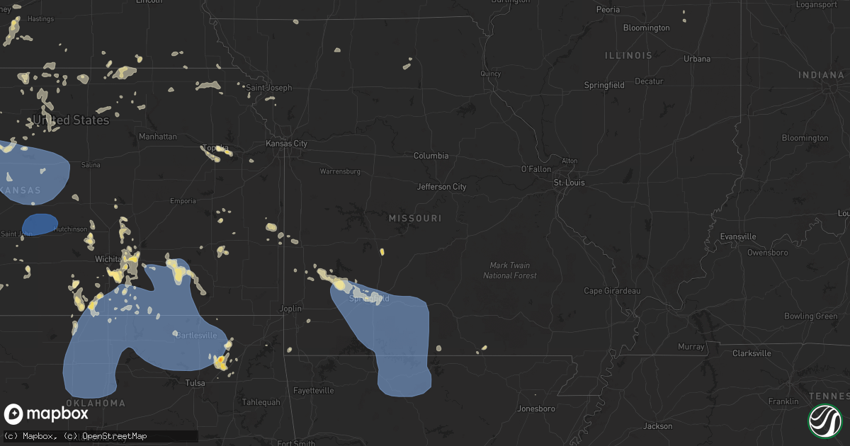
Hail Map in Missouri on June 29, 2025
Get this storm
June 29 map
$229
one time, instant access
Download today. No call, no setup
Keep the $229
Bought the map and want the full workflow? Apply the entire $229 to a subscription within 7 days. None of it is wasted.
Every map, not just this one
This buys you this map. Subscription and you get every map we run, in the markets you choose from a few cities to whole states to nationwide. Plus real-time alerts the moment a storm fires.
Contact data
Name, contact info, occupancy, even credit band for addresses in the footprint. You go from where it hit to who to call.
Become the source they trust
Unlimited branding weather history reports on demand. You already have the documented answer ready for the property owner, and you are the one who showed up with it.
Property data and RoofTrace estimates
Pull up any address you have got, its value and the exact code rules for that jurisdiction, straight from One Click Code. Then RoofTrace estimates the squares, pitch, and roof value, priced the way you price.
Storm reports in Missouri
Missouri
| Date | Description |
|---|---|
| 06/29/20255:42 PM CDT | Large branch fell on house. Time based on radar estimated. |
| 06/29/20255:42 PM CDT | Weather station at emergency managment measured a 68mph wind gust. |
| 06/29/20255:37 PM CDT | *** 4 inj *** four injured by flying debris at the thunder ridge nature arena. |
| 06/29/20255:36 PM CDT | 8-10 in diameter tree top broke... And landed near a camper. |
| 06/29/20255:30 PM CDT | Tree tops broken off in the lampe area. |
| 06/29/20255:30 PM CDT | 6 to 8 inch tree branch broke off. Time based on radar. |
| 06/29/20255:25 PM CDT | Mesonet station fw9611 branson. |
| 06/29/20255:24 PM CDT | 8 inch tree limb down. Time based on radar. |
| 06/29/20255:18 PM CDT | Tree down on road. |
| 06/29/20255:15 PM CDT | 60-70 mph winds downed trees and power lines. Four boats were capsized on table rock lake. |
| 06/29/20255:09 PM CDT | Tree down on selmore road blocking the road. |
| 06/29/20255:09 PM CDT | Tree split on jennifer lane in rogersville. |
| 06/29/20255:09 PM CDT | Tree branch down on hannah drive. |
| 06/29/20255:09 PM CDT | Tree uprooted and another tree split on henderson road. |
| 06/29/20255:06 PM CDT | Tree down across the road. |
| 06/29/20255:05 PM CDT | Lots of tree limbs down a few trees toppled... And power outages. Anemometer and outdoor weather station. |
| 06/29/20255:05 PM CDT | Tree down in the eastbound lane. |
| 06/29/20255:04 PM CDT | Tree down on parch corn road. |
| 06/29/20255:04 PM CDT | Tree blocking the road on bain st. |
| 06/29/20255:04 PM CDT | Tree down on the road. |
| 06/29/20255:04 PM CDT | Tree down on warren st blocking road. |
| 06/29/20255:00 PM CDT | Some trees down and partial road blockage. |
| 06/29/20255:00 PM CDT | Trees down at golf course. |
| 06/29/20255:00 PM CDT | Tree down on tennis st. |
| 06/29/20255:00 PM CDT | Pictures of a fireworks tent blown over. |
| 06/29/20255:00 PM CDT | Tree down blocking roadway. |
| 06/29/20254:59 PM CDT | Tree fell on mobile home no one is injured. |
| 06/29/20254:58 PM CDT | Large tree uprooted and large branches fell on house. Via social media. Time based on radar estimate. |
| 06/29/20254:56 PM CDT | Large tree blocking road. Time based on radar. |
| 06/29/20254:55 PM CDT | Power lines are down across the road... And a tree down. Time based on radar estimate. |
| 06/29/20254:55 PM CDT | 6 inch tree limbs down. Time based on radar estimate. |
| 06/29/20254:55 PM CDT | 1 mile south of cox south hospital has a significant sized tree limb on layfayette court. |
| 06/29/20254:55 PM CDT | Tree down on powerline. |
| 06/29/20254:54 PM CDT | Tree across the road way blocking the road. |
| 06/29/20254:54 PM CDT | Trees down on power lines. Time based on radar estimate. |
| 06/29/20254:54 PM CDT | Tree blocking part of road on s sunrise in a couple of locations... Traffic lights out in several locations along kansas expressway. Power lines down on scenic... Acros |
| 06/29/20254:54 PM CDT | 12 inch limbs down. |
| 06/29/20254:54 PM CDT | Large tree down on road blocking traffic. |
| 06/29/20254:54 PM CDT | Trees down. |
| 06/29/20254:53 PM CDT | Branches blown off... Roof damage. Time based on radar. |
| 06/29/20254:53 PM CDT | Tree blocking roadway. |
| 06/29/20254:53 PM CDT | Tree fell on roadway blocking both lanes. |
| 06/29/20254:53 PM CDT | Large tree broke near the base. Older tree. Time based on radar. Shingles blown off of pawn shop off battlefield and kansas. |
| 06/29/20254:50 PM CDT | 30 diameter elm tree completely uprooted. Location: battlefield... Mo near w weaver rd & ridgecrest dr. |
| 06/29/20254:48 PM CDT | 10 inch limb on house. Across the street there are two uprooted trees on pickup and garage. |
| 06/29/20254:45 PM CDT | Tree branch fell on fence cause damage. |
| 06/29/20254:45 PM CDT | Tree on lines. |
| 06/29/20254:45 PM CDT | Mocomagnet |
| 06/29/20254:45 PM CDT | Large branch on house. |
| 06/29/20254:45 PM CDT | 24 inch tree down. |
| 06/29/20254:43 PM CDT | Large tree down blocking both lanes of west battlefield. |
| 06/29/20254:42 PM CDT | 2 power poles snapped... And partially leaning into the road. |
| 06/29/20254:42 PM CDT | Corrects time of previous tstm wnd dmg report from 1 sw republic. Large branch fell on house. Time based on radar estimated. |
| 06/29/20254:42 PM CDT | Extensive tree damage on the north side of republic. Estimated 40 percent of the city without power. Time estimated from radar. |
| 06/29/20254:42 PM CDT | Line pole down on roadway. Time based on radar estimate. |
| 06/29/20254:42 PM CDT | Whole intersection is blocked by a large tree in the road. |
| 06/29/20254:42 PM CDT | Branches and power lines down. Time based on radar. |
| 06/29/20254:40 PM CDT | Two to three large trees down. |
| 06/29/20254:40 PM CDT | Tree down on powerline. |
| 06/29/20254:39 PM CDT | Tree down blocking road blocking oak st. |
| 06/29/20254:36 PM CDT | Large tree fell on power line. |
| 06/29/20254:36 PM CDT | A power pole was broken. |
| 06/29/20254:36 PM CDT | A local report indicates 63 MPH wind near 5 SSE Willard |
| 06/29/20254:36 PM CDT | Up to 16 inch diameter trees down mm 68 1/2 on i44. |
| 06/29/20254:34 PM CDT | Tree completely blocking road. |
| 06/29/20254:30 PM CDT | Major number of trees uprooted and neighbors old barn leveled. |
| 06/29/20254:30 PM CDT | Trees and power lines down across roads... Tree down on house... Tree down on car in ash grove. |
| 06/29/20254:30 PM CDT | Tree hanging over roadway. |
| 06/29/20254:25 PM CDT | A tree was down due to thunderstorm winds. |
| 06/29/20254:20 PM CDT | 6-8 inch branches down in lawrence county halltown area. Via fire dep. |
| 06/29/20254:20 PM CDT | Powerlines down in the area. |
| 06/29/20254:20 PM CDT | State highway mm closed due to trees and powerlines across roadway. |
| 06/29/20254:20 PM CDT | Tree fell on powerline. |
| 06/29/20254:18 PM CDT | Powerlines down in everton. |
| 06/29/20254:09 PM CDT | Trees fell on powerlines and caused fire near house. |
| 06/29/20254:03 PM CDT | Trees down. |
| 06/29/20254:00 PM CDT | Trees and powerlines down over roadway. |
| 06/29/20254:00 PM CDT | Tree down on powerlines. |
| 06/29/20254:00 PM CDT | Powerlines down on house. |
| 06/29/20254:00 PM CDT | Trees down off state highway z. |
| 06/29/20254:00 PM CDT | In greenfield... Mo 6-8 inch to entire trees uprooted... A metal roof with 1/3 of roof gone. About from well street along 39 hwy south and back east. |
| 06/29/20254:00 PM CDT | Power pole snapped in greenfield on broad st. |
| 06/29/20254:00 PM CDT | A powerline was down due to thunderstorm winds. |
| 06/29/20253:53 PM CDT | Large tree down. |
| 06/29/20253:53 PM CDT | Powerlines down. |
| 06/29/20253:51 PM CDT | Tree just took out powerline in yard... Both down. |
| 06/29/20253:42 PM CDT | Trees down near highway e and highway d. |
| 06/29/20253:00 PM CDT | Multiple trees down and roads blocked in nevada... Mo. |
| 06/29/20251:35 PM CDT | Social media report of downed wires near route f. Time estimated from radar. |
| 06/29/20251:25 PM CDT | Social media report of downed power poles and power lines on route 18 near county road 6001. Time estimated from radar. |
| 06/29/20251:22 PM CDT | Social media reports of downed wires and power outages near route aa. Time estimated from radar. |
All States Impacted by Hail Map on June 29, 2025
Cities Impacted by Hail Map on June 29, 2025
- Custer, SD
- Columbia, PA
- Mount Joy, PA
- Mountville, PA
- Lancaster, PA
- Burchard, NE
- Baileyville, KS
- Steinauer, NE
- Hiawatha, KS
- Robinson, KS
- Horton, KS
- Troy, KS
- Pawnee City, NE
- Hermosa, SD
- Fairburn, SD
- Odell, NE
- Diller, NE
- Falls City, NE
- Villisca, IA
- Nodaway, IA
- New Market, IA
- Bedford, IA
- Blockton, IA
- Gravity, IA
- Sharpsburg, IA
- Grant City, MO
- Sheridan, MO
- Dearborn, MO
- Gilman City, MO
- Agency, MO
- Aurora, KS
- Concordia, KS
- Clyde, KS
- Faucett, MO
- De Kalb, MO
- Saint Joseph, MO
- Spickard, MO
- Clifton, KS
- Morganville, KS
- Clay Center, KS
- Topeka, KS
- Auburn, KS
- Tecumseh, KS
- Wakarusa, KS
- Berryton, KS
- Lecompton, KS
- Lawrence, KS
- Elmer, MO
- La Plata, MO
- New Boston, MO
- Ethel, MO
- Eudora, KS
- Kirksville, MO
- Centre, AL
- Le Roy, KS
- Burlington, KS
- Waverly, KS
- Westphalia, KS
- Wisconsin Rapids, WI
- Mound City, KS
- Iola, WI
- Blue Mound, KS
- Mapleton, KS
- Amherst, WI
- Iola, KS
- Clintonville, WI
- Bear Creek, WI
- Arkdale, WI
- Necedah, WI
- Pulaski, WI
- Bonduel, WI
- Scandinavia, WI
- Waupaca, WI
- Prescott, KS
- Marion, WI
- Tigerton, WI
- Toronto, KS
- Hancock, WI
- Brimson, MN
- Pleasanton, KS
- Fulton, KS
- Two Harbors, MN
- Norwalk, WI
- Fort Scott, KS
- Ogdensburg, WI
- Manawa, WI
- Caledonia, MN
- Yates Center, KS
- Redfield, KS
- Plainfield, WI
- Hume, MO
- Richards, MO
- Newcastle, WY
- Humboldt, KS
- Chanute, KS
- Piqua, KS
- New London, WI
- Benedict, KS
- Buffalo, KS
- Shiocton, WI
- Krakow, WI
- Marathon, TX
- Almond, WI
- Nevada, MO
- Sobieski, WI
- Ochopee, FL
- Pueblo, CO
- Black Creek, WI
- Hill City, SD
- Larsen, WI
- Fremont, WI
- Sparta, WI
- Soldiers Grove, WI
- Readstown, WI
- Sibley, IL
- Strawn, IL
- Forrest, IL
- Abrams, WI
- Seymour, WI
- Cashton, WI
- Westby, WI
- Weyauwega, WI
- Little Suamico, WI
- Lamar, MO
- Viroqua, WI
- Granite Canon, WY
- Waukon, IA
- Cheyenne, WY
- Harpersville, AL
- Fort Stockton, TX
- Columbiana, AL
- Bellvue, CO
- Ontario, WI
- Hillsboro, WI
- La Farge, WI
- Dorchester, IA
- Green Bay, WI
- Liberal, MO
- Wilsonville, AL
- Beulah, WY
- Spearfish, SD
- New Albin, IA
- Lockwood, MO
- Jerico Springs, MO
- Golden City, MO
- Whitewood, SD
- Drake, CO
- Glen Haven, CO
- Rosedale, MD
- Essex, MD
- Shelby, AL
- Middle River, MD
- Greenfield, MO
- Upton, WY
- Carr, CO
- Marion, AL
- Abernathy, TX
- Richland Center, WI
- Centreville, AL
- Everton, MO
- Baltimore, MD
- South Greenfield, MO
- Nunn, CO
- Pierce, CO
- Loveland, CO
- Caulfield, MO
- Dundalk, MD
- Palm City, FL
- Rockford, AL
- Kellyton, AL
- Granby, MO
- Walnut Grove, MO
- Ash Grove, MO
- Willard, MO
- Springfield, MO
- Strafford, MO
- Fair Grove, MO
- North Freedom, WI
- Loganville, WI
- Boston, GA
- Estes Park, CO
- Lyons, CO
- Clanton, AL
- Wellington, CO
- Bois D Arc, MO
- Mount Vernon, MO
- Crane, MO
- Spokane, MO
- Nixa, MO
- Marionville, MO
- Billings, MO
- Halltown, MO
- Republic, MO
- Highlandville, MO
- Reeds Spring, MO
- Aurora, MO
- Rogersville, MO
- Ponce De Leon, MO
- Galena, MO
- Brookline, MO
- Clever, MO
- Miller, MO
- Ozark, MO
- Fordland, MO
- Marshfield, MO
- Chestnutridge, MO
- Walnut Shade, MO
- Sparta, MO
- Ault, CO
- Meriden, WY
- Albin, WY
- Burns, WY
- Buffalo Gap, SD
- Pine Ridge, SD
- Trementina, NM
- Avondale, CO
- Fowler, CO
- Sparrows Point, MD
- Verbena, AL
- Hollister, MO
- Forsyth, MO
- Chadwick, MO
- Rockaway Beach, MO
- Cape Fair, MO
- Bruner, MO
- Oldfield, MO
- Branson, MO
- Bradleyville, MO
- Mansfield, MO
- Taneyville, MO
- Powersite, MO
- Hartville, MO
- Kirbyville, MO
- Seymour, MO
- Ava, MO
- Garrison, MO
- Berthoud, CO
- Briggsdale, CO
- Galeton, CO
- Edgemont, SD
- Edinburg, VA
- Wardensville, WV
- South West City, MO
- Noel, MO
- Ruckersville, VA
- Lagrange, WY
- Lubbock, TX
- Leroy, AL
- Ridgeway, WI
- Jackson, AL
- Juneau, WI
- Hawk Springs, WY
- Shallowater, TX
- Grenville, NM
- Folsom, NM
- Colorado Springs, CO
- Dupree, SD
- Anderson, MO
- Norwood, MO
- Theodosia, MO
- Protem, MO
- Macomb, MO
- Wasola, MO
- Squires, MO
- Noble, MO
- Cedarcreek, MO
- Zanoni, MO
- Mountain Grove, MO
- Thornfield, MO
- Gainesville, MO
- Isabella, MO
- Brixey, MO
- Kissee Mills, MO
- Drury, MO
- Rueter, MO
- Hardenville, MO
- Pontiac, MO
- Mountain Home, AR
- Oakland, AR
- Clarkridge, AR
- Yellville, AR
- Lakeview, AR
- Midway, AR
- Lead Hill, AR
- Peel, AR
- Omaha, AR
- Gassville, AR
- Cotter, AR
- Flippin, AR
- Bull Shoals, AR
- Pyatt, AR
- Harrison, AR
- Everton, AR
- Horicon, WI
- Egg Harbor Township, NJ
- Mays Landing, NJ
- Immokalee, FL
- Yoder, CO
- Tecumseh, MO
- Lyman, NE
- Harrisburg, NE
- Yoder, WY
- Batesland, SD
- Porcupine, SD
- Manderson, SD
- Wounded Knee, SD
- Hot Springs, SD
- Lance Creek, WY
- Boise City, OK
- Gering, NE
- Torrington, WY
- Kermit, TX
- Augusta, KS
- Glendo, WY
- Hartville, WY
- Wheatland, WY
- Veteran, WY
- Sardis, AL
- Kannapolis, NC
- Afton, OK
- Towanda, KS
- Piedmont, KS
- Eureka, KS
- El Dorado, KS
- Mitchell, NE
- Morrill, NE
- Scottsbluff, NE
- Valley Springs, AR
- Calico Rock, AR
- Norfork, AR
- Gilbert, AR
- Harriet, AR
- Marshall, AR
- Western Grove, AR
- Pindall, AR
- Saint Joe, AR
- Summit, AR
- Marble Falls, AR
- Hasty, AR
- Chelsea, OK
- Washington, GA
- Tignall, GA
- Rayle, GA
- Mulvane, KS
- Derby, KS
- Haysville, KS
- Nowata, OK
- Elkhart, KS
- Benton, KS
- Ontonagon, MI
- Ewen, MI
- Grove Hill, AL
- Huntersville, NC
- Agate, CO
- Gordon, NE
- Minatare, NE
- Lingle, WY
- Harrison, NE
- Jay Em, WY
- Severy, KS
- Douglass, KS
- Latham, KS
- Goodwell, OK
- Fort Morgan, CO
- Claremore, OK
- Vinita, OK
- Leon, KS
- Andover, KS
- Ramah, CO
- Oelrichs, SD
- Chadron, NE
- Whitney, NE
- Martin, SD
- Merriman, NE
- Howard, KS
- Marsland, NE
- Hemingford, NE
- Fall River, KS
- Moline, KS
- Elk Falls, KS
- Garrett, WY
- Columbia, VA
- Simla, CO
- Palmyra, WI
- Eagle, WI
- Deer Trail, CO
- Cassville, WI
- Farwell, TX
- Arlington Heights, IL
- Mount Prospect, IL
- Wheeling, IL
- Prospect Heights, IL
- Buffalo Grove, IL
- Deerfield, IL
- Lincolnshire, IL
- Des Plaines, IL
- Highland Park, IL
- Glenview, IL
- Northbrook, IL
- Keyes, OK
- Hanna, WY
- Longton, KS
- Bayard, NE
- Angora, NE
- Hay Springs, NE
- Alliance, NE
- Udall, KS
- Seneca, KS
- Beatrice, NE
- Malmo, NE
- Rose Hill, KS
- Guymon, OK
- Goochland, VA
- Atlanta, KS
- Grenola, KS
- Cambridge, KS
- Hoven, SD
- Lebanon, SD
- Gettysburg, SD
- Tolstoy, SD
- Java, SD
- Onaka, SD
- Bowdle, SD
- Roscoe, SD
- Faulkton, SD
- Seneca, SD
- Highmore, SD
- Orient, SD
- Onida, SD
- Cresbard, SD
- Ipswich, SD
- Northville, SD
- Redfield, SD
- Ashton, SD
- Rockham, SD
- Mansfield, SD
- Fort Laramie, WY
- Chugwater, WY
- Thayer, MO
- Whitman, NE
- Rushville, NE
- Rock, KS
- Winfield, KS
- Belle Plaine, KS
- Oxford, KS
- Burden, KS
- Arkansas City, KS
- Geuda Springs, KS
- Peru, KS
- Pawhuska, OK
- Chautauqua, KS
- Sedan, KS
- Cedar Vale, KS
- Dexter, KS
- Shidler, OK
- Newkirk, OK
- Maple City, KS
- Caney, KS
- Copan, OK
- Niotaze, KS
- Havana, KS
- Elk City, KS
- Limon, CO
- Texico, NM
- Dewey, OK
- Bartlesville, OK
- Wann, OK
- Delaware, OK
- Karval, CO
- Wild Horse, CO
- Kit Carson, CO
- Walsh, CO
- Hugo, CO
- Medicine Bow, WY
- Clovis, NM
- Haswell, CO
- Portales, NM
- Westport, SD
- Aberdeen, SD
- Mellette, SD
- Brentford, SD
- Warner, SD
- Hyannis, NE
- Ponca City, OK
- Burbank, OK
- Kaw City, OK
- Ochelata, OK
- Lenapah, OK
- Arriba, CO
- Stanardsville, VA
- Millersburg, MI
- Lakin, KS
- Wellington, KS
- Onaway, MI
- Woodford, VA
- Hawks, MI
- Guernsey, WY
- Johnson, KS
- Norwich, KS
- Argonia, KS
- Harper, KS
- Barnsdall, OK
- Fairfax, OK
- Wynona, OK
- Ralston, OK
- Ramona, OK
- Marland, OK
- Talala, OK
- Mullen, NE
- Douglas, WY
- Oologah, OK
- Milton, KS
- Buffalo Junction, VA
- Red Oak, VA
- Scottsburg, VA
- Danville, KS
- Caldwell, KS
- Mayfield, KS
- Cheyenne Wells, CO
- Arapahoe, CO
- Sharon Springs, KS
- San Jon, NM
- Milan, KS
- Collinsville, OK
- Pawnee, OK
- Skiatook, OK
- Hominy, OK
- Vera, OK
- Sperry, OK
- Osage, OK
- Prue, OK
- Crawford, NE
- Freeport, KS
- Lake Forest, IL
- Highwood, IL
- Bluff City, KS
- Elida, NM
- Milwaukee, WI
- Menomonee Falls, WI
- Brookfield, WI
- Butler, WI
- Elm Grove, WI
- Mequon, WI
- Tryon, NE
- Ellsworth, NE
- Braman, OK
- Weskan, KS
- Medford, OK
- Conway Springs, KS
- Channing, TX
- Nash, OK
- Adair, OK
- Whitewater, KS
- Stapleton, NE
- Peck, KS
- Newton, KS
- Tribune, KS
- Venango, NE
- Brule, NE
- Pryor, OK
- Catoosa, OK
- Wakita, OK
- Ogallala, NE
- Grant, NE
- Madrid, NE
- South Haven, KS
- Nardin, OK
- Lamont, OK
- Blackwell, OK
- Deer Creek, OK
- Carrier, OK
- Kremlin, OK
- Hunter, OK
- Tonkawa, OK
- Enid, OK
- Pond Creek, OK
- Red Rock, OK
- Covington, OK
- Billings, OK
- Garber, OK
- Fairmont, OK
- Perry, OK
- Wallace, KS
- Burlington, CO
- Fredonia, KS
- Inola, OK
- Oxford, NE
- Ford, VA
- Floyd, NM
- Oberlin, KS
- Danbury, NE
- Imperial, NE
- Wauneta, NE
- Elsie, NE
- Wallace, NE
- Clearwater, KS
- Kyle, SD
- Arcola, MO
- Pratt, KS
- S Coffeyville, OK
- Beaver City, NE
- Goodland, KS
- Burrton, KS
- Maxwell, NE
- North Platte, NE
- Arnold, NE
- Brady, NE
- Enders, NE
- Hayes Center, NE
- Halstead, KS
- Edison, NE
- Wichita, KS
- Paragould, AR
- Dighton, KS
- Peabody, KS
- McCook, NE
- Ulysses, KS
- Sedgwick, KS
- Stafford, KS
- St John, KS
- Hudson, KS
- Nickerson, KS
- Abbyville, KS
- Raymond, KS
- Sylvia, KS
- Alden, KS
- Plevna, KS
- Sterling, KS
- Alma, NE
- Winona, KS
- Wilcox, NE
- Kanorado, KS
- Isabel, KS
- Norcatur, KS
- Mount Hope, KS
- Haviland, KS
- Comstock, NE
- Manchester, OK
- Gothenburg, NE
- Utica, KS
- Sawyer, KS
- Callaway, NE
- Elwood, NE
- Moorefield, NE
- Willow Island, NE
- Cozad, NE
- Lexington, NE
- Eustis, NE
- Farnam, NE
- Palisade, NE
- Benkelman, NE
- Culbertson, NE
- Stratton, NE
- Stillwater, OK
- Hennessey, OK
- Lucien, OK
- Marshall, OK
- Bison, OK
- Waukomis, OK
- Douglas, OK
- Mulhall, OK
- Crescent, OK
- Dover, OK
- Coyle, OK
- Orlando, OK
- Guthrie, OK
- Drummond, OK
- Oconto, NE
- Potwin, KS
- Elbing, KS
- Burns, KS
- Arcadia, NE
- Westerville, NE
- Upland, NE
- Hildreth, NE
- Minden, NE
- Holdrege, NE
- Norton, KS
- Dresden, KS
- Jennings, KS
- Clayton, KS
- Edson, KS
- Monument, KS
- Kingman, KS
- Colby, KS
- Ansley, NE
- Campbell, NE
- Eddyville, NE
- Moundridge, KS
- Colwich, KS
- Wilmore, KS
- Bladen, NE
- Holstein, NE
- Cheney, KS
- Murdock, KS
- Mason City, NE
- Arapahoe, NE
- Trenton, NE
- Maywood, NE
- Ellinwood, KS
- Chase, KS
- Lenora, KS
- Windom, KS
- Selden, KS
- Ashton, NE
- Heartwell, NE
- Atwood, KS
- Morland, KS
- Andale, KS
- Medicine Lodge, KS
- Brewster, KS
- Sumner, NE
- Smithfield, NE
- Bertrand, NE
- Overton, NE
- Loomis, NE
- Hill City, KS
- Litchfield, NE
- Mcpherson, KS
- Hillsboro, KS
- Rexford, KS
- Hoxie, KS
- Marquette, KS
- Bogue, KS
- Hoisington, KS
- Miller, NE
- Riverdale, NE
- Amherst, NE
- Kearney, NE
- Elm Creek, NE
- Odessa, NE
- Penokee, KS
- Phillipsburg, KS
- Nelson, NE
- Russell, KS
- Oakley, KS
- Levant, KS
- Gem, KS
- Loup City, NE
- Agra, KS
- Lebanon, KS
- Smith Center, KS
- Guide Rock, NE
- Republican City, NE
- Oak, NE
- Superior, NE
- Kensington, KS
- Kenesaw, NE
- Wilson, KS
- Ravenna, NE
- Hazard, NE
- Logan, KS
- Stockton, KS
- Grinnell, KS
- Ellsworth, KS
- Grainfield, KS
- Burr Oak, KS
- Mankato, KS
- Quinter, KS
- Bridgeton, NJ
- Palco, KS
- Buffalo, MO
- Louisburg, MO
- Gibbon, NE
- Urbana, MO
- Sun City, KS
- Plainville, KS
- Gilead, NE
- Esbon, KS
- Wood River, NE
- Shelton, NE
- Hebron, NE
- Gaylord, KS
- Fairbury, NE
- Reynolds, NE
- Natoma, KS
- Woodston, KS
- Webber, KS
- Formoso, KS
- Courtland, KS
- Alton, KS
- Victoria, KS
- Scandia, KS
- Belleville, KS
- Osborne, KS
- Paradise, KS
- Glen Elder, KS
- Gorham, KS
- Waldo, KS
- Palmer, KS
- Jewell, KS
- Washington, KS
- Narka, KS
- Haddam, KS
- Downs, KS
- Linn, KS
- Beloit, KS
- Barnes, KS
- Randolph, KS
- Lucas, KS
- Morrowville, KS
- Mahaska, KS
- Hunter, KS
- Tipton, KS
- Sylvan Grove, KS
- Hollenberg, KS
- Steele City, NE
- Endicott, NE
- Ellis, KS
- Hays, KS
- Catharine, KS
- Luray, KS
- Dorrance, KS
- Olmitz, KS
- Walker, KS
- Otis, KS
- Great Bend, KS
- Bunker Hill, KS
- Claflin, KS
- Pfeifer, KS
- Bison, KS
- Albert, KS
- La Crosse, KS
- Holyrood, KS
- Brookville, KS
- Geneseo, KS
- Lincoln, KS
- Bushton, KS
- Beverly, KS
- Kanopolis, KS
- Lyons, KS
- Lorraine, KS
- Greenleaf, KS
- Hanover, KS
- Frankfort, KS
- Vermillion, KS
- Matheson, CO
- Oneida, KS
- Sabetha, KS
- Atchison, KS
- Bendena, KS
- Goff, KS
- Powhattan, KS
- Fairview, KS


