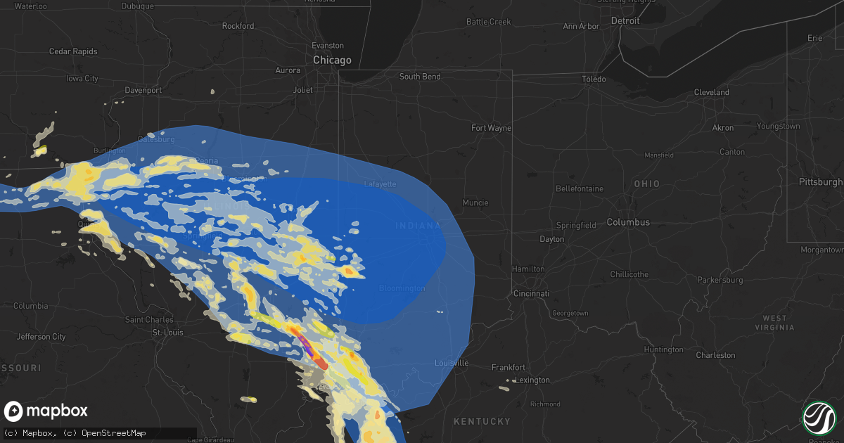
Hail Map in Indiana on June 29, 2023
Get this storm
June 29 map
$229
one time, instant access
Download today. No call, no setup
Keep the $229
Bought the map and want the full workflow? Apply the entire $229 to a subscription within 7 days. None of it is wasted.
Every map, not just this one
This buys you this map. Subscription and you get every map we run, in the markets you choose from a few cities to whole states to nationwide. Plus real-time alerts the moment a storm fires.
Contact data
Name, contact info, occupancy, even credit band for addresses in the footprint. You go from where it hit to who to call.
Become the source they trust
Unlimited branding weather history reports on demand. You already have the documented answer ready for the property owner, and you are the one who showed up with it.
Property data and RoofTrace estimates
Pull up any address you have got, its value and the exact code rules for that jurisdiction, straight from One Click Code. Then RoofTrace estimates the squares, pitch, and roof value, priced the way you price.
Storm reports in Indiana
Indiana
| Date | Description |
|---|---|
| 06/29/20234:03 PM CDT | Tree down at intersection of henley and backmeyer rds. Time estimated from radar. |
| 06/29/20234:02 PM CDT | Tree down. Time estimated from radar. |
| 06/29/20233:57 PM CDT | Large tree down on road. Time estimated by radar. |
| 06/29/20233:56 PM CDT | Tree down. Time estimated by radar. |
| 06/29/20233:51 PM CDT | Tree down on residence. Injuries unknown. Time estimated from radar. |
| 06/29/20233:47 PM CDT | Tree down across roadway. Time estimated from radar. |
| 06/29/20233:46 PM CDT | *** 2 inj *** tree on vehicle. |
| 06/29/20233:46 PM CDT | Tree over road. |
| 06/29/20233:46 PM CDT | Trees down. |
| 06/29/20233:45 PM CDT | Trees also down on power lines. |
| 06/29/20233:32 PM CDT | *** 1 inj *** tree fell on car with occupants... One person injured. Time estimated from radar. |
| 06/29/20233:25 PM CDT | Report on social media of roof damage and a collapsed chimney in seymour. Time estimated via radar. |
| 06/29/20233:25 PM CDT | Trees and power poles reported down in nw decatur county by em. |
| 06/29/20233:22 PM CDT | Trees and power lines down. |
| 06/29/20233:20 PM CDT | Measured gust of 60mph. |
| 06/29/20233:20 PM CDT | Report from mping: trees uprooted or snapped. Time estimated from radar. |
| 06/29/20233:18 PM CDT | Trees reported down on north street. Public estimates 70mph wind gust. |
| 06/29/20233:17 PM CDT | Report from mping: 3-inch tree limbs broken; power poles broken. Time estimated from radar. |
| 06/29/20233:15 PM CDT | Shingle blown off home. Also... Tree down on truck. |
| 06/29/20233:15 PM CDT | Tree down in the right lane of i-65 southbound near in-58. Reports of semi trucks impacted. |
| 06/29/20233:15 PM CDT | Corrects previous tstm wnd gst report from 4 sw columbus. Measured gust of 60mph. |
| 06/29/20233:10 PM CDT | Parke county ema reports damage to several buildings. Lots of trees down in roads... Including 36 and 59. |
| 06/29/20233:09 PM CDT | Report from mping: 3-inch tree limbs broken; power poles broken. |
| 06/29/20233:09 PM CDT | Trees down. |
| 06/29/20233:09 PM CDT | Report from mping: 3-inch tree limbs broken; power poles broken. |
| 06/29/20233:09 PM CDT | Trees down throughout huntingburg on jackson st... Main st... And first ave... Including trees on vehicles and power lines. |
| 06/29/20233:05 PM CDT | Fallen tree on car at d/18th streets. Time estimated from radar. |
| 06/29/20233:02 PM CDT | Numerous large branches down across the bates hendricks neighborhood. |
| 06/29/20233:00 PM CDT | Numerous large branches down. Time estimated from radar. |
| 06/29/20233:00 PM CDT | Large tree uprooted along mill creek road in mitchell. Time estimated via radar. |
| 06/29/20232:59 PM CDT | Report from mping: 1-inch tree limbs broken. |
| 06/29/20232:59 PM CDT | Report from mping: 1-inch tree limbs broken. |
| 06/29/20232:58 PM CDT | Estimated 60 mph squalls. Six inch diameter tree downed. |
| 06/29/20232:57 PM CDT | Report from mping: trees uprooted or snapped. |
| 06/29/20232:55 PM CDT | Numerous trees down and most of town without power. |
| 06/29/20232:55 PM CDT | Awos station ktyq indianapolis exc. |
| 06/29/20232:55 PM CDT | Report from mping: 3-inch tree limbs broken; power poles broken. Time estimated from radar. |
| 06/29/20232:54 PM CDT | Large tree downed in bargersville... Power lines down with it. |
| 06/29/20232:52 PM CDT | Large trees and powerlines down in brookside park. Time estimated via radar. |
| 06/29/20232:50 PM CDT | Several trees and power lines down across monroe county. Duke energy reports widespread outages from the storms. Time estimated from radar. |
| 06/29/20232:50 PM CDT | Report from mping: trees uprooted or snapped. |
| 06/29/20232:50 PM CDT | Corrects previous tstm wnd dmg report from 2 wnw monument circle. Multiple large tree branches down between 10th and 16th street along belmont avenue. Time estimated vi |
| 06/29/20232:48 PM CDT | Time estimated. Several medium sized tree limbs knocked down. |
| 06/29/20232:48 PM CDT | Asos station kbmg bloomington. |
| 06/29/20232:47 PM CDT | Asos station kind indianapolis. |
| 06/29/20232:45 PM CDT | Small tree and large lims down on 200 s in west of lebanon and south of state road 39. |
| 06/29/20232:45 PM CDT | Large tree branch down in the nws ind parking lot. |
| 06/29/20232:45 PM CDT | Tree on house. Time estimated from radar. |
| 06/29/20232:45 PM CDT | Trees blocking furnas road just off s high school road. Time estimated via radar. |
| 06/29/20232:42 PM CDT | Large tree fell on a car... Was unoccupied at the time. Numerous power lines down across frankfort. |
| 06/29/20232:41 PM CDT | Large tree branches down on wilbur road north of martinsville. Time estimated via radar. |
| 06/29/20232:40 PM CDT | Trees down blocking 86th/1000n on marion/hendricks county line. |
| 06/29/20232:40 PM CDT | Report from mping: 1-inch tree limbs broken. |
| 06/29/20232:36 PM CDT | Multiple trees reported down in lafayette. Time estimated via radar. |
| 06/29/20232:35 PM CDT | Large branches down east of 74 on 200 s. |
| 06/29/20232:30 PM CDT | Power out for half of greencastle due to storms. Numerous trees down. Some barns have lost roofs. |
| 06/29/20232:30 PM CDT | Part of roof came off barn. Time estimated from radar. |
| 06/29/20232:26 PM CDT | A local report indicates 63 MPH wind near North Salem |
| 06/29/20232:25 PM CDT | Power pole snapped and trees down just south of lagoda. Time estimated via radar. |
| 06/29/20232:20 PM CDT | Tree on a dwelling in heritage lake... No injuries reported. Time estimated via radar. |
| 06/29/20232:20 PM CDT | Tree on a dwelling in heritage lake... No injuries reported. Time estimated via radar. |
| 06/29/20232:20 PM CDT | Porch collapse and tree on house... Trees down in the area. |
| 06/29/20232:16 PM CDT | Social media report of roof damage to a structure and multiple trees down off of 231. Time estimated via radar. |
| 06/29/20232:15 PM CDT | Part of roof ripped from building. Time estimated from radar. |
| 06/29/20232:15 PM CDT | Awos station kcfj crawfordsville. |
| 06/29/20232:14 PM CDT | 4-8 inch tree limbs reported downed throughout town. |
| 06/29/20232:12 PM CDT | Report of highway sign down us-41/us-52. |
| 06/29/20232:06 PM CDT | Large tree down on ohio blvd blocking all lanes. |
| 06/29/20232:06 PM CDT | Damage to a metal building reported. Photo from social media shows walls collapsed and roof blown back. Time estimated via radar. |
| 06/29/20232:05 PM CDT | Large tree fell onto a house. Powerlines also down at 8th and indiana in terre haute. |
| 06/29/20232:05 PM CDT | 65 mph gust estimated at sky king airport. |
| 06/29/20232:04 PM CDT | Report of multiple trees down in between attica and veedersburg. Time estimated via radar. |
| 06/29/20232:00 PM CDT | Multiple ham radio operators report widespread trees and powerlines down in terre haute. Estimated 70-80mph winds. |
| 06/29/20232:00 PM CDT | Large branches downed and blocking milligan hill road. Time estimated via radar. |
| 06/29/20231:59 PM CDT | Delayed report of a large tree down on a house in veedersburg. Time estimated via radar. |
| 06/29/20231:58 PM CDT | Tree branches reported down in kingman. Time estimated via radar. |
| 06/29/20231:52 PM CDT | Delayed report of a large tree down on a house in covington. Time estimated via radar. |
| 06/29/20231:50 PM CDT | Multiple large tree branches down between 10th and 16th street along belmont avenue. Time estimated via radar. |
| 06/29/202310:25 AM CDT | Time estimated from radar. |
| 06/29/20239:22 AM CDT | Report of very high winds. |
| 06/29/20239:18 AM CDT | Spotter estimates 70 mph gusts. |
| 06/29/20239:15 AM CDT | A local report indicates 70 MPH wind near 3 WNW Newburgh |
| 06/29/20239:12 AM CDT | Multiple trees down in the area. |
| 06/29/20239:10 AM CDT | Garage roof damaged by tree falling onto it. Late report. |
| 06/29/20238:58 AM CDT | Awning destroyed by wind. |
| 06/29/20238:55 AM CDT | Numerous trees snapped or uprooted in the town of grandview. |
| 06/29/20238:50 AM CDT | Trees down... Mobile home blown over with entrapment. |
| 06/29/20238:44 AM CDT | Semis blown over on us 231 in rockport. |
| 06/29/20238:28 AM CDT | Horse barn destroyed. Time estimated by radar. |
| 06/29/20238:25 AM CDT | Tree across the roadway on east holiday lake road. Time estimated based on radar. |
| 06/29/20237:50 AM CDT | Estimated 50 to 60 mph winds. |
| 06/29/20237:45 AM CDT | Trees down and roof blown off of shed. |
| 06/29/20237:45 AM CDT | Hail ranging from ping pong to golf ball sized in oakland city. |
| 06/28/20238:10 PM CDT | Reports of uprooted trees and shingle damage in the same area. |
| 06/28/20238:06 PM CDT | A maple tree was blown down near 851 alvord blvd in evansville. Other large limbs down in the area. |
| 06/28/20237:44 PM CDT | A local report indicates 1.00 inch wind near Owensville |
| 06/28/20237:44 PM CDT | A local report indicates 1.00 inch wind near Owensville |
| 06/28/20237:35 PM CDT | Damage to a greenhouse at same locations as the measured gust. |
All States Impacted by Hail Map on June 29, 2023
Cities Impacted by Hail Map on June 29, 2023
- Frankfort, KS
- Blue Rapids, KS
- Marysville, KS
- Vermillion, KS
- Axtell, KS
- Hazleton, IN
- Patoka, IN
- Petersburg, IN
- Francisco, IN
- Urbana, IL
- Champaign, IL
- Philo, IL
- Tuscola, IL
- Charleston, IL
- Villa Grove, IL
- Hindsboro, IL
- Tolono, IL
- Camargo, IL
- Ashmore, IL
- Westfield, IL
- Craig, MO
- Falls City, NE
- Mound City, MO
- Rulo, NE
- Centralia, KS
- Baileyville, KS
- Corning, KS
- Oneida, KS
- Seneca, KS
- Sabetha, KS
- Bern, KS
- Wetmore, KS
- Goff, KS
- Oakland City, IN
- Winslow, IN
- Paris, IL
- Netawaka, KS
- Fairview, KS
- Powhattan, KS
- Morrill, KS
- Salem, NE
- Hiawatha, KS
- Whiting, KS
- Horton, KS
- White Cloud, KS
- Everest, KS
- Robinson, KS
- Dennison, IL
- Rock Port, MO
- Westboro, MO
- Tarkio, MO
- Fairfax, MO
- Pickering, MO
- Burlington Junction, MO
- Elmo, MO
- Sheridan, MO
- Clearmont, MO
- Parnell, MO
- Hopkins, MO
- Worth, MO
- Maryville, MO
- Grant City, MO
- Eagleville, MO
- Princeton, MO
- Ridgeway, MO
- Lucerne, MO
- Cainsville, MO
- Blythedale, MO
- Ravenwood, MO
- Denver, MO
- Martinsville, MO
- Skidmore, MO
- Pollock, MO
- Unionville, MO
- Albany, MO
- Spickard, MO
- Harris, MO
- Newtown, MO
- Milan, MO
- Bethany, MO
- Gentry, MO
- Galt, MO
- Clyde, MO
- Gilman City, MO
- New Hampton, MO
- Trenton, MO
- Conception Junction, MO
- Stanberry, MO
- Humphreys, MO
- McFall, MO
- Barnard, MO
- Coffey, MO
- Pattonsburg, MO
- Darlington, MO
- Jamesport, MO
- Conception, MO
- Guilford, MO
- Maysville, MO
- Bolckow, MO
- King City, MO
- Jameson, MO
- Graham, MO
- Rosendale, MO
- Rea, MO
- Union Star, MO
- Savannah, MO
- Maitland, MO
- Fillmore, MO
- Forest City, MO
- Oregon, MO
- Muscotah, KS
- Holton, KS
- Effingham, KS
- Lancaster, KS
- Troy, KS
- Highland, KS
- Atchison, KS
- Rushville, MO
- Denton, KS
- Cummings, KS
- Bendena, KS
- Saint Joseph, MO
- De Kalb, MO
- Faucett, MO
- Wathena, KS
- Elwood, KS
- Amazonia, MO
- Cosby, MO
- Easton, MO
- Agency, MO
- Greentop, MO
- Queen City, MO
- Worthington, MO
- Kirksville, MO
- Novinger, MO
- Green City, MO
- La Plata, MO
- Green Castle, MO
- Decker, IN
- Vincennes, IN
- Allendale, IL
- Mount Carmel, IL
- Princeton, IN
- Cynthiana, IN
- Fort Branch, IN
- Owensville, IN
- Haubstadt, IN
- Poseyville, IN
- Evansville, IN
- Wadesville, IN
- Elberfeld, IN
- Henderson, KY
- Reed, KY
- Chandler, IN
- Robards, KY
- Boonville, IN
- Spottsville, KY
- Newburgh, IN
- Richland, IN
- Rockport, IN
- Lynnville, IN
- Owensboro, KY
- Tennyson, IN
- Maceo, KY
- Reynolds Station, KY
- Lewisport, KY
- Philpot, KY
- Hawesville, KY
- Chrisney, IN
- Gentryville, IN
- Grandview, IN
- Browning, MO
- Mercer, MO
- Calhoun, KY
- Bloomfield, IA
- Selma, IA
- Floris, IA
- Douds, IA
- Memphis, MO
- Downing, MO
- Brashear, MO
- Gibbs, MO
- Baring, MO
- Novelty, MO
- Edina, MO
- Rutledge, MO
- Hurdland, MO
- Whitesville, KY
- Fordsville, KY
- Utica, KY
- Sebree, KY
- Slaughters, KY
- Sacramento, KY
- Hanson, KY
- Rumsey, KY
- Hartford, KY
- Island, KY
- Livermore, KY
- Olaton, KY
- Falls Of Rough, KY
- Dundee, KY
- Horse Branch, KY
- Centertown, KY
- Arbela, MO
- Luray, MO
- Gorin, MO
- Wyaconda, MO
- Donnellson, IA
- Kahoka, MO
- Knox City, MO
- Farmington, IA
- Argyle, IA
- Monticello, MO
- La Belle, MO
- Alexandria, MO
- Saint Patrick, MO
- Revere, MO
- Canton, MO
- Lewistown, MO
- Wayland, MO
- Williamstown, MO
- Caneyville, KY
- Beaver Dam, KY
- Greenville, KY
- Madisonville, KY
- Rosine, KY
- Central City, KY
- Bremen, KY
- Rockport, KY
- Cromwell, KY
- Drakesboro, KY
- Graham, KY
- McHenry, KY
- Powderly, KY
- Terre Haute, IN
- Cory, IN
- Keokuk, IA
- Mendon, IL
- Loraine, IL
- Warsaw, IL
- Ursa, IL
- West Point, IL
- Sutter, IL
- Montrose, IA
- Fort Madison, IA
- Carthage, IL
- Elvaston, IL
- Wever, IA
- Hamilton, IL
- Basco, IL
- West Point, IA
- Nauvoo, IL
- Dallas City, IL
- Niota, IL
- La Prairie, IL
- Augusta, IL
- Golden, IL
- Plymouth, IL
- Tennessee, IL
- La Harpe, IL
- Bowen, IL
- Colchester, IL
- Macomb, IL
- Blandinsville, IL
- Littleton, IL
- Industry, IL
- Rushville, IL
- Raritan, IL
- Adair, IL
- Roseville, IL
- Smithshire, IL
- Bushnell, IL
- Lomax, IL
- Good Hope, IL
- Sciota, IL
- Vermont, IL
- Stronghurst, IL
- Media, IL
- Carman, IL
- Burlington, IA
- Beechmont, KY
- Beech Creek, KY
- Browder, KY
- Belton, KY
- Dunmor, KY
- Morgantown, KY
- Auburn, KY
- Rochester, KY
- Lewisburg, KY
- Russellville, KY
- Bowling Green, KY
- Jetson, KY
- Rockfield, KY
- Roundhill, KY
- Huntsville, IL
- Camden, IL
- Ipava, IL
- Marietta, IL
- Bardolph, IL
- Astoria, IL
- Prairie City, IL
- Browning, IL
- Table Grove, IL
- Ellisville, IL
- Gilson, IL
- Berwick, IL
- Cuba, IL
- Havana, IL
- Maquon, IL
- Lewistown, IL
- Saint Augustine, IL
- Smithfield, IL
- Abingdon, IL
- Cameron, IL
- Avon, IL
- Canton, IL
- London Mills, IL
- Bath, IL
- Farmington, IL
- Elmwood, IL
- Princeville, IL
- Yates City, IL
- Liverpool, IL
- Saint David, IL
- Glasford, IL
- Dunlap, IL
- Hanna City, IL
- Edwards, IL
- Trivoli, IL
- Bryant, IL
- Brimfield, IL
- Fairview, IL
- Norris, IL
- Mapleton, IL
- Green Valley, IL
- Mason City, IL
- Pekin, IL
- Peoria, IL
- Forest City, IL
- Kingston Mines, IL
- San Jose, IL
- Easton, IL
- Manito, IL
- Kilbourne, IL
- Topeka, IL
- Coatsburg, IL
- Camp Point, IL
- Timewell, IL
- Clayton, IL
- Mount Sterling, IL
- Chandlerville, IL
- Beardstown, IL
- Frederick, IL
- Virginia, IL
- Ashland, IL
- Greenview, IL
- Petersburg, IL
- Sherman, IL
- Arenzville, IL
- Cantrall, IL
- Tallula, IL
- Oakford, IL
- Athens, IL
- Pleasant Plains, IL
- Springfield, IL
- Olmstead, KY
- Sharon Grove, KY
- Adairville, KY
- Springfield, TN
- Woodburn, KY
- Franklin, KY
- Scottsville, KY
- Westmoreland, TN
- Orlinda, TN
- Lafayette, TN
- Alvaton, KY
- Adolphus, KY
- Portland, TN
- Bethpage, TN
- Cross Plains, TN
- Elkton, KY
- Cedar Hill, TN
- Whites Creek, TN
- White House, TN
- Gallatin, TN
- Cottontown, TN
- Goodlettsville, TN
- Joelton, TN
- Hendersonville, TN
- Greenbrier, TN
- Lebanon, TN
- Castalian Springs, TN
- Mount Juliet, TN
- Hartsville, TN
- Riddleton, TN
- Dixon Springs, TN
- Carthage, TN
- Madison, TN
- Pleasant Shade, TN
- La Grange, MO
- Quincy, IL
- Fowler, IL
- Paloma, IL
- Baylis, IL
- Liberty, IL
- Griggsville, IL
- Chambersburg, IL
- Meredosia, IL
- Versailles, IL
- Perry, IL
- Winchester, IL
- Concord, IL
- Bluffs, IL
- Jacksonville, IL
- Chapin, IL
- Alexander, IL
- Waverly, IL
- New Berlin, IL
- Auburn, IL
- Loami, IL
- Franklin, IL
- Chatham, IL
- Murrayville, IL
- Woodson, IL
- Barry, IL
- Pittsfield, IL
- New Salem, IL
- Waggoner, IL
- Modesto, IL
- Glenarm, IL
- Farmersville, IL
- Roodhouse, IL
- Palmyra, IL
- Girard, IL
- Divernon, IL
- Virden, IL
- Thayer, IL
- Galesburg, IL
- Monmouth, IL
- Kirkwood, IL
- Gladstone, IL
- Biggsville, IL
- Williamsfield, IL
- Oneida, IL
- Victoria, IL
- Knoxville, IL
- Dahinda, IL
- Laura, IL
- East Galesburg, IL
- Henderson, IL
- Wyoming, IL
- La Fayette, IL
- Alexis, IL
- Altona, IL
- Wataga, IL
- Galva, IL
- Speer, IL
- Toulon, IL
- Washington, IL
- Henry, IL
- Sparland, IL
- Delavan, IL
- Creve Coeur, IL
- Mossville, IL
- Groveland, IL
- South Pekin, IL
- Bradford, IL
- Peoria Heights, IL
- East Peoria, IL
- Lacon, IL
- Edelstein, IL
- Tremont, IL
- Morton, IL
- Metamora, IL
- Chillicothe, IL
- Lowpoint, IL
- Washburn, IL
- McLean, IL
- Deer Creek, IL
- Congerville, IL
- Stanford, IL
- Williamsville, IL
- New Holland, IL
- Lawndale, IL
- Carlock, IL
- Clinton, IL
- Varna, IL
- Hartsburg, IL
- Mackinaw, IL
- Hopedale, IL
- Beason, IL
- Danvers, IL
- Mount Pulaski, IL
- Emden, IL
- Armington, IL
- Lincoln, IL
- Elkhart, IL
- Goodfield, IL
- Atlanta, IL
- Waynesville, IL
- Middletown, IL
- Roanoke, IL
- Minier, IL
- Kenney, IL
- Bloomington, IL
- Shirley, IL
- Eureka, IL
- Chestnut, IL
- Maroa, IL
- Dawson, IL
- Edinburg, IL
- Latham, IL
- Rochester, IL
- Harristown, IL
- Mount Auburn, IL
- Stonington, IL
- Taylorville, IL
- Buffalo, IL
- Bulpitt, IL
- Decatur, IL
- Mechanicsburg, IL
- Kincaid, IL
- Warrensburg, IL
- Riverton, IL
- Pawnee, IL
- Tovey, IL
- Morrisonville, IL
- Niantic, IL
- Illiopolis, IL
- Blue Mound, IL
- Old Hickory, TN
- Nashville, TN
- Hermitage, TN
- Watertown, TN
- Normal, IL
- Benson, IL
- El Paso, IL
- Hudson, IL
- La Rose, IL
- Dana, IL
- Rutland, IL
- Secor, IL
- Gridley, IL
- Heyworth, IL
- Toluca, IL
- Minonk, IL
- Nokomis, IL
- Harvel, IL
- Witt, IL
- Palmer, IL
- Pana, IL
- Raymond, IL
- Owaneco, IL
- Tower Hill, IL
- Mt Zion, IL
- Forsyth, IL
- Lakewood, IL
- Shelbyville, IL
- Assumption, IL
- Le Roy, IL
- Bethany, IL
- Oconee, IL
- Ramsey, IL
- Herrick, IL
- Downs, IL
- Boody, IL
- Lane, IL
- Wapella, IL
- Macon, IL
- Beecher City, IL
- Moweaqua, IL
- Towanda, IL
- Lexington, IL
- Cowden, IL
- Oreana, IL
- Argenta, IL
- Findlay, IL
- Rosamond, IL
- Ohlman, IL
- Dalton City, IL
- Bingham, IL
- Saint Elmo, IL
- Altamont, IL
- Bonaparte, IA
- Mount Sterling, IA
- Du Bois, NE
- Cameron, MO
- Mount Vernon, IN
- Illinois City, IL
- Muscatine, IA
- Hannibal, MO
- Lawrenceville, IL
- Patterson, IL
- Pearl, IL
- White Hall, IL
- Hillview, IL
- Monroe City, MO
- Hunnewell, MO
- Lewis, IA
- Atlantic, IA
- Robinson, IL
- Flat Rock, IL
- Powersville, MO
- Palmyra, MO
- Farmersburg, IN
- Gallatin, MO
- Olney, IL
- Golden Gate, IL
- Milton, IA
- Shelbyville, MO
- Emden, MO
- Crossville, IL
- Moulton, IA
- Marshall, IL
- Kansas, IL
- Brazil, IN
- Redmon, IL
- Oakland, IL
- Brocton, IL
- Glenwood, MO
- Livonia, MO
- Earlington, KY
- Casey, IL
- Home, KS
- Onaga, KS
- Kinderhook, IL
- Hull, IL
- Taylor, MO
- New Canton, IL
- Payson, IL
- Plainville, IL
- Rockport, IL
- Crofton, KY
- Dawson Springs, KY
- Saint Charles, KY
- Altamont, MO
- Oaktown, IN
- Wiota, IA
- Cumberland, IA
- Sumner, IL
- Monroe City, IN
- Pimento, IN
- Lewis, IN
- Clay City, IN
- Otwell, IN
- Jasper, IN
- Stendal, IN
- Allensville, KY
- Hopkinsville, KY
- Carmi, IL
- Pleasant Hill, IL
- Agency, IA
- Batavia, IA
- Packwood, IA
- Eldon, IA
- Fairfield, IA
- Martinsville, IL
- Frankford, MO
- New London, MO
- West York, IL
- Fairbanks, IN
- Sullivan, IN
- West Union, IL
- Grayville, IL
- Newman, IL
- New Harmony, IN
- New Haven, IL
- Kidder, MO
- Annapolis, IL
- Nebo, KY
- Manitou, KY
- Carlinville, IL
- Greenfield, IL
- Hettick, IL
- Chesterfield, IL
- Keosauqua, IA
- Dale, IN
- Fairfield, IL
- Cisne, IL
- Geff, IL
- Spurgeon, IN
- Parkersburg, IL
- Hutsonville, IL
- Arthur, IL
- Atwood, IL
- Arcola, IL
- Lovington, IL
- Hammond, IL
- West Terre Haute, IN
- Bridgeport, IL
- Percival, IA
- Union, NE
- Henderson, IA
- Macedonia, IA
- Hamilton, MO
- Saint Francisville, IL
- Keota, IA
- Calhoun, IL
- Nortonville, KY
- Albion, IL
- West Salem, IL
- Breckenridge, MO
- Shelburn, IN
- Kane, IL
- Fieldon, IL
- Sullivan, IL
- Corydon, KY
- Mortons Gap, KY
- Humboldt, IL
- Medora, IL
- Shipman, IL
- Dixon, KY
- White Plains, KY
- Lerna, IL
- Oblong, IL
- Toledo, IL
- Greenup, IL
- Palestine, IL
- Flanagan, IL
- Mode, IL
- Fisher, IL
- Forrest, IL
- Saunemin, IL
- Anchor, IL
- Bellflower, IL
- Cullom, IL
- Foosland, IL
- Pontiac, IL
- Cisco, IL
- Colfax, IL
- Windsor, IL
- De Land, IL
- Cropsey, IL
- Mahomet, IL
- Strasburg, IL
- Dewitt, IL
- Bement, IL
- Saybrook, IL
- Cooksville, IL
- Farmer City, IL
- Graymont, IL
- Chenoa, IL
- Fairbury, IL
- Mansfield, IL
- Strawn, IL
- Arrowsmith, IL
- Ellsworth, IL
- Monticello, IL
- Gibson City, IL
- Chatsworth, IL
- White Heath, IL
- Shumway, IL
- Weldon, IL
- Cerro Gordo, IL
- Milmine, IL
- La Place, IL
- Long Point, IL
- Sibley, IL
- Guthrie, KY
- Griffin, IN
- Trenton, KY
- Waverly, KY
- Burnt Prairie, IL
- Evanston, IN
- Norris City, IL
- Claremont, IL
- Providence, KY
- Holland, IN
- Lamar, IN
- Piper City, IL
- Odell, IL
- Litchfield, IL
- Nilwood, IL
- Irving, IL
- Butler, IL
- Fillmore, IL
- Coffeen, IL
- Taylor Springs, IL
- Hillsboro, IL
- Brownstown, IL
- Donnellson, IL
- Walshville, IL
- Mulberry Grove, IL
- Greenville, IL
- Sorento, IL
- Vandalia, IL
- Panama, IL
- Smithboro, IL
- Gillespie, IL
- Keyesport, IL
- Mount Olive, IL
- Sheldon, IL
- Gays, IL
- Armstrong, IL
- Ogden, IL
- Pesotum, IL
- Sadorus, IL
- Danforth, IL
- Loda, IL
- Gifford, IL
- Ivesdale, IL
- Savoy, IL
- Sidney, IL
- Stewardson, IL
- Buckley, IL
- Royal, IL
- Elliott, IL
- Gilman, IL
- Saint Joseph, IL
- Watseka, IL
- Crescent City, IL
- Onarga, IL
- Melvin, IL
- Rossville, IL
- Neoga, IL
- Seymour, IL
- Penfield, IL
- Thawville, IL
- Mattoon, IL
- Rantoul, IL
- Bondville, IL
- Hoopeston, IL
- Milford, IL
- Wellington, IL
- Rankin, IL
- Dewey, IL
- Potomac, IL
- Roberts, IL
- Ludlow, IL
- Paxton, IL
- Ashkum, IL
- Kempton, IL
- Thomasboro, IL
- Cissna Park, IL
- Kinmundy, IL
- Shobonier, IL
- Salem, IL
- Alma, IL
- Saint Peter, IL
- Vernon, IL
- Patoka, IL
- Sigel, IL
- Longview, IL
- Xenia, IL
- Homer, IL
- Montrose, IL
- Trilla, IL
- Jewett, IL
- Iuka, IL
- Broadlands, IL
- Teutopolis, IL
- Danville, IL
- Muncie, IL
- Dieterich, IL
- Rinard, IL
- Fairmount, IL
- Edgewood, IL
- Effingham, IL
- Oakwood, IL
- Mason, IL
- Murdock, IL
- Watson, IL
- Farina, IL
- Wheeler, IL
- Allerton, IL
- Louisville, IL
- Flora, IL
- Fithian, IL
- Collison, IL
- Dana, IN
- Ridge Farm, IL
- State Line, IN
- Rossville, IN
- Westpoint, IN
- Vermilion, IL
- Attica, IN
- Battle Ground, IN
- Perrysville, IN
- Hume, IL
- Ambia, IN
- Monticello, IN
- Covington, IN
- Flora, IN
- Cayuga, IN
- Alvin, IL
- Georgetown, IL
- Sidell, IL
- Sailor Springs, IL
- Wingate, IN
- Williamsport, IN
- Mellott, IN
- Kingman, IN
- Romney, IN
- Metcalf, IL
- Hidalgo, IL
- Crawfordsville, IN
- Willow Hill, IL
- Waynetown, IN
- Otterbein, IN
- Buck Creek, IN
- Clinton, IN
- Montezuma, IN
- Boswell, IN
- Pine Village, IN
- New Richmond, IN
- Noble, IL
- Lafayette, IN
- Westville, IL
- Newton, IL
- Ingraham, IL
- Remington, IN
- West Lebanon, IN
- Delphi, IN
- Brookston, IN
- Goodland, IN
- Bringhurst, IN
- Catlin, IL
- Marshall, IN
- Chalmers, IN
- Templeton, IN
- Veedersburg, IN
- Hillsdale, IN
- Clay City, IL
- Indianola, IL
- Hillsboro, IN
- Tilton, IL
- Chrisman, IL
- Fowler, IN
- Dayton, IN
- Yale, IL
- Kentland, IN
- Linden, IN
- West Lafayette, IN
- Earl Park, IN
- Bismarck, IL
- Bloomingdale, IN
- Henning, IL
- Newtown, IN
- Camden, IN
- Stockland, IL
- Oxford, IN
- Wolcott, IN
- Sainte Marie, IL
- Bone Gap, IL
- New Ross, IN
- Mulberry, IN
- Waveland, IN
- Browns, IL
- Merom, IN
- Dugger, IN
- Bridgeton, IN
- Carbon, IN
- Carlisle, IN
- Jasonville, IN
- New Goshen, IN
- Ladoga, IN
- Russellville, IN
- Dundas, IL
- Riley, IN
- West Liberty, IL
- Alamo, IN
- Coalmont, IN
- Staunton, IN
- Reelsville, IN
- Mount Erie, IL
- Knightsville, IN
- New Market, IN
- Bicknell, IN
- Stoy, IL
- Bruceville, IN
- Hymera, IN
- Clarks Hill, IN
- Cutler, IN
- Edwardsport, IN
- Universal, IN
- Mecca, IN
- Rockville, IN
- Roachdale, IN
- Darlington, IN
- Bainbridge, IN
- Centerpoint, IN
- Rosedale, IN
- Linton, IN
- Harmony, IN
- Frankfort, IN
- Greencastle, IN
- Colfax, IN
- Gordonsville, TN
- La Vergne, TN
- Nolensville, TN
- Antioch, TN
- Murfreesboro, TN
- Lascassas, TN
- Smyrna, TN
- Brentwood, TN
- Arrington, TN
- Franklin, TN
- Rockvale, TN
- Thompsons Station, TN
- College Grove, TN
- Eagleville, TN
- Spring Hill, TN
- Christiana, TN
- Unionville, TN
- Milton, TN
- Milwaukee, WI
- Lyons, IN
- Westphalia, IN
- Lizton, IN
- Ragsdale, IN
- Coatesville, IN
- Lebanon, IN
- Freelandville, IN
- Worthington, IN
- Danville, IN
- Coal City, IN
- Freedom, IN
- Putnamville, IN
- Bowling Green, IN
- Pittsboro, IN
- Cloverdale, IN
- Thorntown, IN
- Sandborn, IN
- Switz City, IN
- Spencer, IN
- Fillmore, IN
- Wheatland, IN
- Patricksburg, IN
- North Salem, IN
- Poland, IN
- Amo, IN
- Jamestown, IN
- Advance, IN
- Reynolds, IN
- Yeoman, IN
- Quincy, IN
- Fairmount, IN
- Forest, IN
- Newberry, IN
- Martinsville, IN
- Noblesville, IN
- Washington, IN
- Zionsville, IN
- Indianapolis, IN
- Whitestown, IN
- Sheridan, IN
- Young America, IN
- Tipton, IN
- Greentown, IN
- Kirklin, IN
- Kokomo, IN
- Converse, IN
- Kempton, IN
- Russiaville, IN
- Avon, IN
- Plainfield, IN
- Carmel, IN
- Plainville, IN
- Monrovia, IN
- Sharpsville, IN
- Brownsburg, IN
- Sweetser, IN
- Marion, IN
- Walton, IN
- Jonesboro, IN
- Stilesville, IN
- Bloomfield, IN
- Galveston, IN
- Summitville, IN
- Westfield, IN
- Paragon, IN
- Cicero, IN
- Miami, IN
- Clayton, IN
- Gosport, IN
- Bunker Hill, IN
- Burlington, IN
- Elwood, IN
- Michigantown, IN
- Windfall, IN
- Amboy, IN
- Swayzee, IN
- Atlanta, IN
- Elnora, IN
- Mooresville, IN
- Arcadia, IN
- Goldsmith, IN
- Logansport, IN
- Odin, IL
- Sandoval, IL
- Carlyle, IL
- Johnsonville, IL
- Kell, IL
- Bellmont, IL
- Bluford, IL
- Centralia, IL
- Wayne City, IL
- Keenes, IL
- Ellery, IL
- Sims, IL
- Dix, IL
- Texico, IL
- Walnut Hill, IL
- Pocahontas, IL
- Mount Vernon, IL
- Springerton, IL
- Barnhill, IL
- Mill Shoals, IL
- Enfield, IL
- Dahlgren, IL
- Bell Buckle, TN
- Chapel Hill, TN
- Columbia, TN
- Shelbyville, TN
- Lewisburg, TN
- Petersburg, TN
- Belfast, TN
- Culleoka, TN
- Fayetteville, TN
- Cornersville, TN
- Pulaski, TN
- Lynnville, TN
- Frankewing, TN
- Douglas, WY
- Midwest, WY
- Casper, WY
- Owensburg, IN
- Loogootee, IN
- Montgomery, IN
- Stinesville, IN
- Springville, IN
- Odon, IN
- Solsberry, IN
- Crane, IN
- Bloomington, IN
- Scotland, IN
- Ellettsville, IN
- Williams, IN
- Bedford, IN
- Brooklyn, IN
- Unionville, IN
- Shoals, IN
- Avoca, IN
- Camby, IN
- Gas City, IN
- Alexandria, IN
- Uniontown, KY
- McLeansboro, IL
- Fishers, IN
- Cannelburg, IN
- West Newton, IN
- Crothersville, IN
- Jonesville, IN
- Flat Rock, IN
- Huntingburg, IN
- Branchville, IN
- Milltown, IN
- Medora, IN
- Taswell, IN
- Waldron, IN
- Trafalgar, IN
- Dubois, IN
- Markleville, IN
- English, IN
- Seymour, IN
- Columbus, IN
- Greenfield, IN
- Whiteland, IN
- Fowlerton, IN
- Sulphur, IN
- New Palestine, IN
- Fredericksburg, IN
- Santa Claus, IN
- West Baden Springs, IN
- Pendleton, IN
- Tunnelton, IN
- Tell City, IN
- Marengo, IN
- Scipio, IN
- Franklin, IN
- Oolitic, IN
- Brownstown, IN
- Anderson, IN
- Leopold, IN
- Greensburg, IN
- Saint Anthony, IN
- Clifford, IN
- Frankton, IN
- Scottsburg, IN
- Fountaintown, IN
- Mccordsville, IN
- Heltonville, IN
- Saint Paul, IN
- Bristow, IN
- Campbellsburg, IN
- Morristown, IN
- Manilla, IN
- Birdseye, IN
- Ingalls, IN
- Fortville, IN
- Needham, IN
- Bargersville, IN
- Salem, IN
- Hardinsburg, IN
- Freetown, IN
- Charlottesville, IN
- Grantsburg, IN
- Celestine, IN
- Beech Grove, IN
- Lapel, IN
- Edinburgh, IN
- Vallonia, IN
- Carthage, IN
- French Lick, IN
- Cannelton, IN
- Elizabethtown, IN
- Taylorsville, IN
- Orleans, IN
- Middletown, IN
- Boggstown, IN
- Greenwood, IN
- Troy, IN
- Saint Meinrad, IN
- Paoli, IN
- Hartsville, IN
- Nineveh, IN
- Eckerty, IN
- Morgantown, IN
- Westport, IN
- Mitchell, IN
- Depauw, IN
- Nashville, IN
- Fairland, IN
- Velpen, IN
- Lincoln City, IN
- Saint Croix, IN
- Shelbyville, IN
- Hope, IN
- Grammer, IN
- Leavenworth, IN
- Norman, IN
- Maxwell, IN
- Wilkinson, IN
- Ferdinand, IN
- Gwynneville, IN
- Schnellville, IN
- Trinidad, CO
- Rushville, IN
- Shirley, IN
- Knightstown, IN
- Homer, IN
- Arlington, IN
- Milroy, IN
- Straughn, IN
- Webster, IN
- New Castle, IN
- Farmland, IN
- Milton, IN
- Hagerstown, IN
- Parker City, IN
- Mays, IN
- Fountain City, IN
- Greens Fork, IN
- Falmouth, IN
- Daleville, IN
- Springport, IN
- Connersville, IN
- Losantville, IN
- Williamsburg, IN
- Glenwood, IN
- Centerville, IN
- Cambridge City, IN
- Spiceland, IN
- Lewisville, IN
- Economy, IN
- Yorktown, IN
- Gaston, IN
- Mooreland, IN
- Modoc, IN
- Richmond, IN
- Muncie, IN
- Lynn, IN
- Kennard, IN
- Selma, IN
- Trinchera, CO
- Glendo, WY
- Brownsville, IN
- Laurel, IN
- Gillette, WY
- Royal Center, IN
- Monon, IN
- Idaville, IN
- Burnettsville, IN
- Bosler, WY
- Commiskey, IN
- North Vernon, IN
- Butlerville, IN
- Paris Crossing, IN
- Holton, IN
- Vernon, IN
- Pekin, IN
- Austin, IN
- Osgood, IN
- Palmyra, IN
- Glenrock, WY
- Borden, IN
- Lexington, IN
- Henryville, IN
- New Salisbury, IN
- Underwood, IN
- Corydon, IN
- Greenville, IN
- Deputy, IN
- Ramsey, IN
- Battletown, KY
- Waynesboro, TN
- Lawrenceburg, TN
- Westpoint, TN
- Hill City, SD
- Marion, IL
- Johnston City, IL
- Pittsburg, IL
- Georgetown, IN
- Union Star, KY
- Floyds Knobs, IN
- Rhodelia, KY
- Derby, IN
- Rome, IN
- Stephensport, KY
- Cloverport, KY
- Mauckport, IN
- Crandall, IN
- Payneville, KY
- Hardinsburg, KY
- Central, IN
- Jeffersonville, IN
- Laconia, IN
- Webster, KY
- Memphis, IN
- Elizabeth, IN
- Prospect, KY
- Charlestown, IN
- Madison, IN
- Louisville, KY
- Dupont, IN
- Clarksville, IN
- Guston, KY
- Lanesville, IN
- Sellersburg, IN
- Hanover, IN
- Marysville, IN
- Brandenburg, KY
- Nabb, IN
- Otisco, IN
- New Middletown, IN
- New Washington, IN
- New Albany, IN
- Goshen, KY
- Cheyenne, WY
- Loretto, TN
- Custer, KY
- Rineyville, KY
- Fort Knox, KY
- Harned, KY
- Westview, KY
- Irvington, KY
- Glenview, KY
- Muldraugh, KY
- Garfield, KY
- Cecilia, KY
- West Point, KY
- Ekron, KY
- Shepherdsville, KY
- Vine Grove, KY
- Iron City, TN
- Five Points, TN
- Anderson, AL
- Lexington, AL
- Saint Joseph, TN
- Rogersville, AL
- Manville, WY
- Conifer, CO
- Morrison, CO
- Littleton, CO
- Denver, CO
- Wheat Ridge, CO
- Commerce City, CO
- Fort Collins, CO
- Golden, CO
- Lyons, CO
- Black Hawk, CO
- Boulder, CO
- Laporte, CO
- Wellington, CO
- Loveland, CO
- Ward, CO
- Nederland, CO
- Bellvue, CO
- Kim, CO
- Aurora, CO
- Athens, AL
- Town Creek, AL
- Moulton, AL
- Mount Hope, AL
- Lagrange, WY
- Bazine, KS
- Watkins, CO
- Meriden, WY
- Haleyville, AL
- Double Springs, AL
- Bennett, CO
- Alexander, KS
- White Cloud, MI
- Newaygo, MI
- Albin, WY
- Hawk Springs, WY
- Shawnee, WY
- Cedar Valley, UT
- Guernsey, WY
- Arvada, CO
- Muscle Shoals, AL
- Hersey, MI
- Bitely, MI
- Reed City, MI
- Paris, MI
- Lusk, WY
- Ochopee, FL
- Orr, MN
- Kaycee, WY
- Moorcroft, WY
- Fremont, MI
- Laramie, WY
- Loranger, LA
- Hohenwald, TN
- Hampshire, TN
- Duck River, TN
- Killen, AL
- Courtland, AL
- Isabella, MN
- Bunker Hill, IL
- Staunton, IL
- Newcastle, WY
- Folsom, LA
- Amite, LA
- Independence, LA
- Jay Em, WY
- Hillsboro, AL
- Idledale, CO
- Indian Hills, CO
- Hesperia, MI
- Miami, FL
- Husser, LA
- Covington, LA
- Herrin, IL
- Energy, IL
- Carterville, IL
- Abita Springs, LA
- Mandeville, LA
- Westwego, LA
- Summertown, TN
- Leoma, TN
- Florence, AL
- Strasburg, CO
- Hoffman, IL
- Harrisburg, NE
- Carbon Hill, AL
- Berry, AL
- Townley, AL
- Trego, WI
- Springbrook, WI
- Howard City, MI
- Pierson, MI
- Sand Lake, MI
- Grant, MI
- Pine, CO
- Bailey, CO
- Byers, CO
- Ashland, WI
- Northport, AL
- Tuscaloosa, AL
- Fort Morgan, CO
- Granite Canon, WY
- Rock River, WY
- Merriman, NE
- Whitman, NE
- Hay Springs, NE
- Rushville, NE
- Ellsworth, NE
- Lakeside, NE
- Cody, NE
- Valentine, NE
- Ashby, NE
- Bingham, NE
- Woodrow, CO
- Hyannis, NE
- Wiggins, CO
- Cedar Springs, MI
- Gowen, MI
- Greenville, MI
- Coral, MI
- Trufant, MI
- Lakeview, MI
- Brush, CO
- Buford, WY
- Mullen, NE
- Thedford, NE
- Garrett, WY
- Johnstown, NE
- Seneca, NE
- Wood Lake, NE
- Elsmere, NE
- Ainsworth, NE
- Long Pine, NE
- Morley, MI
- Lingle, WY
- Torrington, WY
- Marsland, NE
- Hemingford, NE
- Finland, MN
- Hartville, WY
- Lysite, WY
- Fort Laramie, WY
- Plum City, WI
- Pepin, WI
- Maiden Rock, WI
- Nelson, WI
- Durand, WI
- Arkansaw, WI
- Crawford, NE
- Chadron, NE
- Whitney, NE
- Springfield, CO
- Russellville, AL
- Harrison, NE
- Granada, MN
- Blue Earth, MN
- Keenesburg, CO
- Manter, KS
- Pritchett, CO
- New Orleans, LA
- Gordon, NE
- Pine Ridge, SD
- Mason, WI
- Alliance, NE
- Fairmont, MN
- Bridgeport, NE
- Ness City, KS
- Eldridge, AL
- Oshkosh, NE
- Rawlins, WY
- Upson, WI
- Iron Belt, WI
- Kiester, MN
- Bricelyn, MN
- Arthur, NE
- Rockford, MI
- Hurley, WI
- Mercer, WI
- Pine Bluffs, WY
- Buffalo Creek, CO
- Shoshoni, WY
- Lake City, MI
- Stanton, MI
- Six Lakes, MI
- Big Rapids, MI
- Minong, WI
- Gordon, WI
- Lynn, AL
- Tuscumbia, AL
- Leighton, AL
- Houston, AL
- Nauvoo, AL
- Danville, AL
- Lakin, KS
- Van Tassell, WY
- Englewood, CO
- Jeffrey City, WY
- Princeton, IL
- Ohio, IL
- Lafitte, LA
- Alcova, WY
- Bassett, NE
- Burwell, NE
- Taylor, NE
- Venango, NE
- Champion, NE
- Imperial, NE
- Grant, NE
- Madrid, NE
- Wauneta, NE
- Elsie, NE
- Hayes Center, NE
- Wallace, NE
- Dickens, NE
- Maywood, NE
- Wellfleet, NE
- Firth, NE
- Adams, NE
- Sterling, NE
- Douglas, NE
- Roggen, CO
- Riverton, NE
- Campbell, NE
- Ewen, MI
- Glenwood, IA
- Phillips, WI
- Ashland, NE
- Greenwood, NE
- Benedict, NE
- Tobias, NE
- Orleans, NE
- Lewellen, NE
- Lemoyne, NE
- Thurman, IA
- Pacific Junction, IA
- Grand Rapids, MI
- Belmont, MI
- Nehawka, NE
- Avoca, NE
- Gresham, NE
- Waco, NE
- Stromsburg, NE
- York, NE
- Hastings, NE
- Smith Center, KS
- Kensington, KS
- Bloomington, NE
- Broomfield, CO
- Hudson, CO
- Paradise, KS
- Waldo, KS
- Oxford, NE
- Giltner, NE
- Amherst, CO
- Arapahoe, NE
- Belding, MI
- Leoti, KS
- Deerfield, KS
- McCracken, KS
- Gretna, NE
- Murdock, NE
- Alvo, NE
- Waverly, NE
- Marienthal, KS
- Cambridge, NE
- Holbrook, NE
- Wilsonville, NE
- Kenesaw, NE
- Juniata, NE
- Holstein, NE
- Roseland, NE
- Doniphan, NE
- Aurora, NE
- Brewster, NE
- Bradshaw, NE
- Franklin, NE
- Wilber, NE
- Guide Rock, NE
- Superior, NE
- Lawrence, NE
- Bladen, NE
- Shickley, NE
- Geneva, NE
- Hays, KS
- Ellis, KS
- Valparaiso, NE
- Dwight, NE
- Akron, CO
- Lowell, MI
- Ada, MI
- Red Feather Lakes, CO
- Malvern, IA
- Lawrenceburg, KY
- Las Animas, CO
- Hampton, NE
- Tie Siding, WY
- Oneill, NE
- Livermore, CO
- Johnson, KS
- Russell, KS
- Dorrance, KS
- Bunker Hill, KS
- Scott City, KS
- Murray, NE
- Sparta, MI
- Comstock Park, MI
- Wyoming, MI
- Otis, CO
- Dunbar, NE
- Roca, NE
- Lincoln, NE
- Otoe, NE
- Unadilla, NE
- Syracuse, NE
- Imogene, IA
- Shenandoah, IA
- Palmyra, NE
- Bennet, NE
- Panama, NE
- Hickman, NE
- Elmwood, NE
- Eagle, NE
- Corbin, KY
- Williamsburg, KY
- Hallam, NE
- Martell, NE
- Emerson, IA
- Hastings, IA
- Yuma, CO
- Tabor, IA
- Sidney, IA
- Nebraska City, NE
- Louisville, NE
- Springfield, NE
- Watson, MO
- Red Oak, IA
- Clarinda, IA
- Braddyville, IA
- Kellerton, IA
- Hatfield, MO
- Mount Ayr, IA
- New Market, IA
- Bedford, IA
- Western, NE
- Swanton, NE
- Crete, NE
- Hamburg, IA
- Cook, NE
- Talmage, NE
- Corning, IA
- Carson, IA
- Salvisa, KY
- Harrodsburg, KY
- Essex, IA
- Blockton, IA
- Benton, IA
- Redding, IA
- Plattsmouth, NE
- Sylvan Grove, KS
- Farragut, IA
- Brock, NE
- Versailles, KY
- Rockholds, KY
- Osceola, IA
- Murray, IA
- Woodburn, IA
- Riverton, IA
- Peru, NE
- Sedalia, CO
- Creston, IA
- New Virginia, IA
- Blanchard, IA
- Northboro, IA
- Afton, IA
- Lorimor, IA
- Thayer, IA


