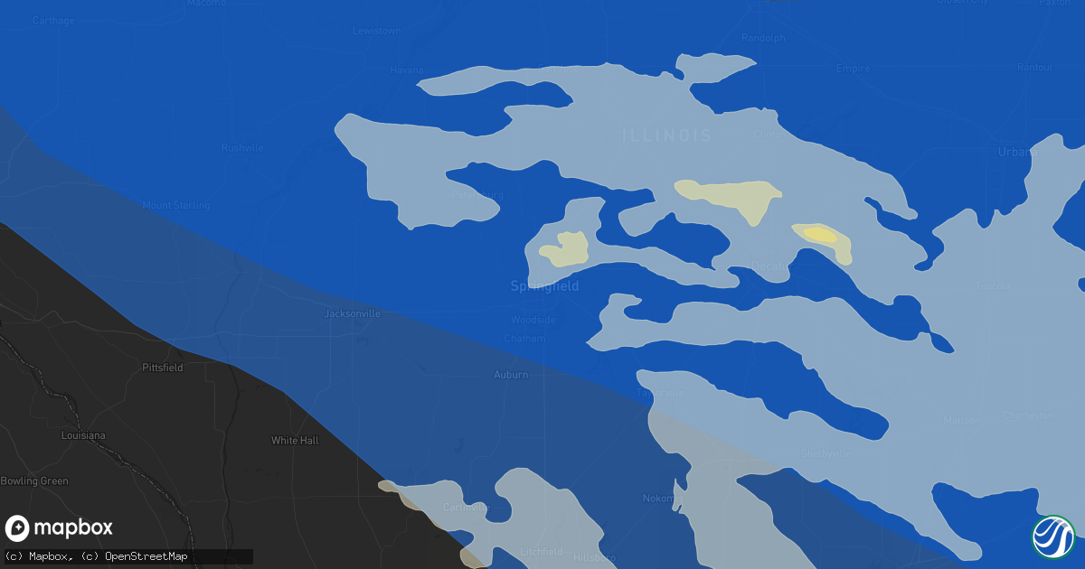
Hail Map in Springfield, IL on June 29, 2023
Get this storm
June 29 map
$229
one time, instant access
Download today. No call, no setup
Keep the $229
Bought the map and want the full workflow? Apply the entire $229 to a subscription within 7 days. None of it is wasted.
Every map, not just this one
This buys you this map. Subscription and you get every map we run, in the markets you choose from a few cities to whole states to nationwide. Plus real-time alerts the moment a storm fires.
Contact data
Name, contact info, occupancy, even credit band for addresses in the footprint. You go from where it hit to who to call.
Become the source they trust
Unlimited branding weather history reports on demand. You already have the documented answer ready for the property owner, and you are the one who showed up with it.
Property data and RoofTrace estimates
Pull up any address you have got, its value and the exact code rules for that jurisdiction, straight from One Click Code. Then RoofTrace estimates the squares, pitch, and roof value, priced the way you price.
Storm reports in Springfield, IL
Springfield, IL
| Date | Description |
|---|---|
| 06/29/202312:20 PM CDT | Large tree limbs down at intersection of spring and edwards in springfield. |
| 06/29/202312:20 PM CDT | Large tree blown down onto a chain link fence... Destroying the fence. Time estimated by radar. |
| 06/29/202312:20 PM CDT | Trash dumpster downtown blown into a window... Causing it to shatter. |
| 06/29/202312:19 PM CDT | Two trees were blown over. |
| 06/29/202312:19 PM CDT | Two trees were blown over. Irport champaign il 4004 8827 portion of the terminal roof was ripped off... Causing airport closure. Via wc |
| 06/29/202312:17 PM CDT | A local report indicates 61 MPH wind near Capital Airport |
| 06/29/202312:15 PM CDT | At least 15 power poles down. Time estimated by radar. |
| 06/29/202312:15 PM CDT | One foot diameter tree snapped in half... Just north of i-72. |
| 06/29/202312:02 PM CDT | Swop member reported 8-10 power poles snapped along dirksen pkwy from thunderstorm winds. |
All States Impacted by Hail Map on June 29, 2023
All Cities Impacted by Hail Map on June 29, 2023
- Frankfort, KS
- Blue Rapids, KS
- Marysville, KS
- Vermillion, KS
- Axtell, KS
- Hazleton, IN
- Patoka, IN
- Petersburg, IN
- Francisco, IN
- Urbana, IL
- Champaign, IL
- Philo, IL
- Tuscola, IL
- Charleston, IL
- Villa Grove, IL
- Hindsboro, IL
- Tolono, IL
- Camargo, IL
- Ashmore, IL
- Westfield, IL
- Craig, MO
- Falls City, NE
- Mound City, MO
- Rulo, NE
- Centralia, KS
- Baileyville, KS
- Corning, KS
- Oneida, KS
- Seneca, KS
- Sabetha, KS
- Bern, KS
- Wetmore, KS
- Goff, KS
- Oakland City, IN
- Winslow, IN
- Paris, IL
- Netawaka, KS
- Fairview, KS
- Powhattan, KS
- Morrill, KS
- Salem, NE
- Hiawatha, KS
- Whiting, KS
- Horton, KS
- White Cloud, KS
- Everest, KS
- Robinson, KS
- Dennison, IL
- Rock Port, MO
- Westboro, MO
- Tarkio, MO
- Fairfax, MO
- Pickering, MO
- Burlington Junction, MO
- Elmo, MO
- Sheridan, MO
- Clearmont, MO
- Parnell, MO
- Hopkins, MO
- Worth, MO
- Maryville, MO
- Grant City, MO
- Eagleville, MO
- Princeton, MO
- Ridgeway, MO
- Lucerne, MO
- Cainsville, MO
- Blythedale, MO
- Ravenwood, MO
- Denver, MO
- Martinsville, MO
- Skidmore, MO
- Pollock, MO
- Unionville, MO
- Albany, MO
- Spickard, MO
- Harris, MO
- Newtown, MO
- Milan, MO
- Bethany, MO
- Gentry, MO
- Galt, MO
- Clyde, MO
- Gilman City, MO
- New Hampton, MO
- Trenton, MO
- Conception Junction, MO
- Stanberry, MO
- Humphreys, MO
- McFall, MO
- Barnard, MO
- Coffey, MO
- Pattonsburg, MO
- Darlington, MO
- Jamesport, MO
- Conception, MO
- Guilford, MO
- Maysville, MO
- Bolckow, MO
- King City, MO
- Jameson, MO
- Graham, MO
- Rosendale, MO
- Rea, MO
- Union Star, MO
- Savannah, MO
- Maitland, MO
- Fillmore, MO
- Forest City, MO
- Oregon, MO
- Muscotah, KS
- Holton, KS
- Effingham, KS
- Lancaster, KS
- Troy, KS
- Highland, KS
- Atchison, KS
- Rushville, MO
- Denton, KS
- Cummings, KS
- Bendena, KS
- Saint Joseph, MO
- De Kalb, MO
- Faucett, MO
- Wathena, KS
- Elwood, KS
- Amazonia, MO
- Cosby, MO
- Easton, MO
- Agency, MO
- Greentop, MO
- Queen City, MO
- Worthington, MO
- Kirksville, MO
- Novinger, MO
- Green City, MO
- La Plata, MO
- Green Castle, MO
- Decker, IN
- Vincennes, IN
- Allendale, IL
- Mount Carmel, IL
- Princeton, IN
- Cynthiana, IN
- Fort Branch, IN
- Owensville, IN
- Haubstadt, IN
- Poseyville, IN
- Evansville, IN
- Wadesville, IN
- Elberfeld, IN
- Henderson, KY
- Reed, KY
- Chandler, IN
- Robards, KY
- Boonville, IN
- Spottsville, KY
- Newburgh, IN
- Richland, IN
- Rockport, IN
- Lynnville, IN
- Owensboro, KY
- Tennyson, IN
- Maceo, KY
- Reynolds Station, KY
- Lewisport, KY
- Philpot, KY
- Hawesville, KY
- Chrisney, IN
- Gentryville, IN
- Grandview, IN
- Browning, MO
- Mercer, MO
- Calhoun, KY
- Bloomfield, IA
- Selma, IA
- Floris, IA
- Douds, IA
- Memphis, MO
- Downing, MO
- Brashear, MO
- Gibbs, MO
- Baring, MO
- Novelty, MO
- Edina, MO
- Rutledge, MO
- Hurdland, MO
- Whitesville, KY
- Fordsville, KY
- Utica, KY
- Sebree, KY
- Slaughters, KY
- Sacramento, KY
- Hanson, KY
- Rumsey, KY
- Hartford, KY
- Island, KY
- Livermore, KY
- Olaton, KY
- Falls Of Rough, KY
- Dundee, KY
- Horse Branch, KY
- Centertown, KY
- Arbela, MO
- Luray, MO
- Gorin, MO
- Wyaconda, MO
- Donnellson, IA
- Kahoka, MO
- Knox City, MO
- Farmington, IA
- Argyle, IA
- Monticello, MO
- La Belle, MO
- Alexandria, MO
- Saint Patrick, MO
- Revere, MO
- Canton, MO
- Lewistown, MO
- Wayland, MO
- Williamstown, MO
- Caneyville, KY
- Beaver Dam, KY
- Greenville, KY
- Madisonville, KY
- Rosine, KY
- Central City, KY
- Bremen, KY
- Rockport, KY
- Cromwell, KY
- Drakesboro, KY
- Graham, KY
- McHenry, KY
- Powderly, KY
- Terre Haute, IN
- Cory, IN
- Keokuk, IA
- Mendon, IL
- Loraine, IL
- Warsaw, IL
- Ursa, IL
- West Point, IL
- Sutter, IL
- Montrose, IA
- Fort Madison, IA
- Carthage, IL
- Elvaston, IL
- Wever, IA
- Hamilton, IL
- Basco, IL
- West Point, IA
- Nauvoo, IL
- Dallas City, IL
- Niota, IL
- La Prairie, IL
- Augusta, IL
- Golden, IL
- Plymouth, IL
- Tennessee, IL
- La Harpe, IL
- Bowen, IL
- Colchester, IL
- Macomb, IL
- Blandinsville, IL
- Littleton, IL
- Industry, IL
- Rushville, IL
- Raritan, IL
- Adair, IL
- Roseville, IL
- Smithshire, IL
- Bushnell, IL
- Lomax, IL
- Good Hope, IL
- Sciota, IL
- Vermont, IL
- Stronghurst, IL
- Media, IL
- Carman, IL
- Burlington, IA
- Beechmont, KY
- Beech Creek, KY
- Browder, KY
- Belton, KY
- Dunmor, KY
- Morgantown, KY
- Auburn, KY
- Rochester, KY
- Lewisburg, KY
- Russellville, KY
- Bowling Green, KY
- Jetson, KY
- Rockfield, KY
- Roundhill, KY
- Huntsville, IL
- Camden, IL
- Ipava, IL
- Marietta, IL
- Bardolph, IL
- Astoria, IL
- Prairie City, IL
- Browning, IL
- Table Grove, IL
- Ellisville, IL
- Gilson, IL
- Berwick, IL
- Cuba, IL
- Havana, IL
- Maquon, IL
- Lewistown, IL
- Saint Augustine, IL
- Smithfield, IL
- Abingdon, IL
- Cameron, IL
- Avon, IL
- Canton, IL
- London Mills, IL
- Bath, IL
- Farmington, IL
- Elmwood, IL
- Princeville, IL
- Yates City, IL
- Liverpool, IL
- Saint David, IL
- Glasford, IL
- Dunlap, IL
- Hanna City, IL
- Edwards, IL
- Trivoli, IL
- Bryant, IL
- Brimfield, IL
- Fairview, IL
- Norris, IL
- Mapleton, IL
- Green Valley, IL
- Mason City, IL
- Pekin, IL
- Peoria, IL
- Forest City, IL
- Kingston Mines, IL
- San Jose, IL
- Easton, IL
- Manito, IL
- Kilbourne, IL
- Topeka, IL
- Coatsburg, IL
- Camp Point, IL
- Timewell, IL
- Clayton, IL
- Mount Sterling, IL
- Chandlerville, IL
- Beardstown, IL
- Frederick, IL
- Virginia, IL
- Ashland, IL
- Greenview, IL
- Petersburg, IL
- Sherman, IL
- Arenzville, IL
- Cantrall, IL
- Tallula, IL
- Oakford, IL
- Athens, IL
- Pleasant Plains, IL
- Springfield, IL
- Olmstead, KY
- Sharon Grove, KY
- Adairville, KY
- Springfield, TN
- Woodburn, KY
- Franklin, KY
- Scottsville, KY
- Westmoreland, TN
- Orlinda, TN
- Lafayette, TN
- Alvaton, KY
- Adolphus, KY
- Portland, TN
- Bethpage, TN
- Cross Plains, TN
- Elkton, KY
- Cedar Hill, TN
- Whites Creek, TN
- White House, TN
- Gallatin, TN
- Cottontown, TN
- Goodlettsville, TN
- Joelton, TN
- Hendersonville, TN
- Greenbrier, TN
- Lebanon, TN
- Castalian Springs, TN
- Mount Juliet, TN
- Hartsville, TN
- Riddleton, TN
- Dixon Springs, TN
- Carthage, TN
- Madison, TN
- Pleasant Shade, TN
- La Grange, MO
- Quincy, IL
- Fowler, IL
- Paloma, IL
- Baylis, IL
- Liberty, IL
- Griggsville, IL
- Chambersburg, IL
- Meredosia, IL
- Versailles, IL
- Perry, IL
- Winchester, IL
- Concord, IL
- Bluffs, IL
- Jacksonville, IL
- Chapin, IL
- Alexander, IL
- Waverly, IL
- New Berlin, IL
- Auburn, IL
- Loami, IL
- Franklin, IL
- Chatham, IL
- Murrayville, IL
- Woodson, IL
- Barry, IL
- Pittsfield, IL
- New Salem, IL
- Waggoner, IL
- Modesto, IL
- Glenarm, IL
- Farmersville, IL
- Roodhouse, IL
- Palmyra, IL
- Girard, IL
- Divernon, IL
- Virden, IL
- Thayer, IL
- Galesburg, IL
- Monmouth, IL
- Kirkwood, IL
- Gladstone, IL
- Biggsville, IL
- Williamsfield, IL
- Oneida, IL
- Victoria, IL
- Knoxville, IL
- Dahinda, IL
- Laura, IL
- East Galesburg, IL
- Henderson, IL
- Wyoming, IL
- La Fayette, IL
- Alexis, IL
- Altona, IL
- Wataga, IL
- Galva, IL
- Speer, IL
- Toulon, IL
- Washington, IL
- Henry, IL
- Sparland, IL
- Delavan, IL
- Creve Coeur, IL
- Mossville, IL
- Groveland, IL
- South Pekin, IL
- Bradford, IL
- Peoria Heights, IL
- East Peoria, IL
- Lacon, IL
- Edelstein, IL
- Tremont, IL
- Morton, IL
- Metamora, IL
- Chillicothe, IL
- Lowpoint, IL
- Washburn, IL
- McLean, IL
- Deer Creek, IL
- Congerville, IL
- Stanford, IL
- Williamsville, IL
- New Holland, IL
- Lawndale, IL
- Carlock, IL
- Clinton, IL
- Varna, IL
- Hartsburg, IL
- Mackinaw, IL
- Hopedale, IL
- Beason, IL
- Danvers, IL
- Mount Pulaski, IL
- Emden, IL
- Armington, IL
- Lincoln, IL
- Elkhart, IL
- Goodfield, IL
- Atlanta, IL
- Waynesville, IL
- Middletown, IL
- Roanoke, IL
- Minier, IL
- Kenney, IL
- Bloomington, IL
- Shirley, IL
- Eureka, IL
- Chestnut, IL
- Maroa, IL
- Dawson, IL
- Edinburg, IL
- Latham, IL
- Rochester, IL
- Harristown, IL
- Mount Auburn, IL
- Stonington, IL
- Taylorville, IL
- Buffalo, IL
- Bulpitt, IL
- Decatur, IL
- Mechanicsburg, IL
- Kincaid, IL
- Warrensburg, IL
- Riverton, IL
- Pawnee, IL
- Tovey, IL
- Morrisonville, IL
- Niantic, IL
- Illiopolis, IL
- Blue Mound, IL
- Old Hickory, TN
- Nashville, TN
- Hermitage, TN
- Watertown, TN
- Normal, IL
- Benson, IL
- El Paso, IL
- Hudson, IL
- La Rose, IL
- Dana, IL
- Rutland, IL
- Secor, IL
- Gridley, IL
- Heyworth, IL
- Toluca, IL
- Minonk, IL
- Nokomis, IL
- Harvel, IL
- Witt, IL
- Palmer, IL
- Pana, IL
- Raymond, IL
- Owaneco, IL
- Tower Hill, IL
- Mt Zion, IL
- Forsyth, IL
- Lakewood, IL
- Shelbyville, IL
- Assumption, IL
- Le Roy, IL
- Bethany, IL
- Oconee, IL
- Ramsey, IL
- Herrick, IL
- Downs, IL
- Boody, IL
- Lane, IL
- Wapella, IL
- Macon, IL
- Beecher City, IL
- Moweaqua, IL
- Towanda, IL
- Lexington, IL
- Cowden, IL
- Oreana, IL
- Argenta, IL
- Findlay, IL
- Rosamond, IL
- Ohlman, IL
- Dalton City, IL
- Bingham, IL
- Saint Elmo, IL
- Altamont, IL
- Bonaparte, IA
- Mount Sterling, IA
- Du Bois, NE
- Cameron, MO
- Mount Vernon, IN
- Illinois City, IL
- Muscatine, IA
- Hannibal, MO
- Lawrenceville, IL
- Patterson, IL
- Pearl, IL
- White Hall, IL
- Hillview, IL
- Monroe City, MO
- Hunnewell, MO
- Lewis, IA
- Atlantic, IA
- Robinson, IL
- Flat Rock, IL
- Powersville, MO
- Palmyra, MO
- Farmersburg, IN
- Gallatin, MO
- Olney, IL
- Golden Gate, IL
- Milton, IA
- Shelbyville, MO
- Emden, MO
- Crossville, IL
- Moulton, IA
- Marshall, IL
- Kansas, IL
- Brazil, IN
- Redmon, IL
- Oakland, IL
- Brocton, IL
- Glenwood, MO
- Livonia, MO
- Earlington, KY
- Casey, IL
- Home, KS
- Onaga, KS
- Kinderhook, IL
- Hull, IL
- Taylor, MO
- New Canton, IL
- Payson, IL
- Plainville, IL
- Rockport, IL
- Crofton, KY
- Dawson Springs, KY
- Saint Charles, KY
- Altamont, MO
- Oaktown, IN
- Wiota, IA
- Cumberland, IA
- Sumner, IL
- Monroe City, IN
- Pimento, IN
- Lewis, IN
- Clay City, IN
- Otwell, IN
- Jasper, IN
- Stendal, IN
- Allensville, KY
- Hopkinsville, KY
- Carmi, IL
- Pleasant Hill, IL
- Agency, IA
- Batavia, IA
- Packwood, IA
- Eldon, IA
- Fairfield, IA
- Martinsville, IL
- Frankford, MO
- New London, MO
- West York, IL
- Fairbanks, IN
- Sullivan, IN
- West Union, IL
- Grayville, IL
- Newman, IL
- New Harmony, IN
- New Haven, IL
- Kidder, MO
- Annapolis, IL
- Nebo, KY
- Manitou, KY
- Carlinville, IL
- Greenfield, IL
- Hettick, IL
- Chesterfield, IL
- Keosauqua, IA
- Dale, IN
- Fairfield, IL
- Cisne, IL
- Geff, IL
- Spurgeon, IN
- Parkersburg, IL
- Hutsonville, IL
- Arthur, IL
- Atwood, IL
- Arcola, IL
- Lovington, IL
- Hammond, IL
- West Terre Haute, IN
- Bridgeport, IL
- Percival, IA
- Union, NE
- Henderson, IA
- Macedonia, IA
- Hamilton, MO
- Saint Francisville, IL
- Keota, IA
- Calhoun, IL
- Nortonville, KY
- Albion, IL
- West Salem, IL
- Breckenridge, MO
- Shelburn, IN
- Kane, IL
- Fieldon, IL
- Sullivan, IL
- Corydon, KY
- Mortons Gap, KY
- Humboldt, IL
- Medora, IL
- Shipman, IL
- Dixon, KY
- White Plains, KY
- Lerna, IL
- Oblong, IL
- Toledo, IL
- Greenup, IL
- Palestine, IL
- Flanagan, IL
- Mode, IL
- Fisher, IL
- Forrest, IL
- Saunemin, IL
- Anchor, IL
- Bellflower, IL
- Cullom, IL
- Foosland, IL
- Pontiac, IL
- Cisco, IL
- Colfax, IL
- Windsor, IL
- De Land, IL
- Cropsey, IL
- Mahomet, IL
- Strasburg, IL
- Dewitt, IL
- Bement, IL
- Saybrook, IL
- Cooksville, IL
- Farmer City, IL
- Graymont, IL
- Chenoa, IL
- Fairbury, IL
- Mansfield, IL
- Strawn, IL
- Arrowsmith, IL
- Ellsworth, IL
- Monticello, IL
- Gibson City, IL
- Chatsworth, IL
- White Heath, IL
- Shumway, IL
- Weldon, IL
- Cerro Gordo, IL
- Milmine, IL
- La Place, IL
- Long Point, IL
- Sibley, IL
- Guthrie, KY
- Griffin, IN
- Trenton, KY
- Waverly, KY
- Burnt Prairie, IL
- Evanston, IN
- Norris City, IL
- Claremont, IL
- Providence, KY
- Holland, IN
- Lamar, IN
- Piper City, IL
- Odell, IL
- Litchfield, IL
- Nilwood, IL
- Irving, IL
- Butler, IL
- Fillmore, IL
- Coffeen, IL
- Taylor Springs, IL
- Hillsboro, IL
- Brownstown, IL
- Donnellson, IL
- Walshville, IL
- Mulberry Grove, IL
- Greenville, IL
- Sorento, IL
- Vandalia, IL
- Panama, IL
- Smithboro, IL
- Gillespie, IL
- Keyesport, IL
- Mount Olive, IL
- Sheldon, IL
- Gays, IL
- Armstrong, IL
- Ogden, IL
- Pesotum, IL
- Sadorus, IL
- Danforth, IL
- Loda, IL
- Gifford, IL
- Ivesdale, IL
- Savoy, IL
- Sidney, IL
- Stewardson, IL
- Buckley, IL
- Royal, IL
- Elliott, IL
- Gilman, IL
- Saint Joseph, IL
- Watseka, IL
- Crescent City, IL
- Onarga, IL
- Melvin, IL
- Rossville, IL
- Neoga, IL
- Seymour, IL
- Penfield, IL
- Thawville, IL
- Mattoon, IL
- Rantoul, IL
- Bondville, IL
- Hoopeston, IL
- Milford, IL
- Wellington, IL
- Rankin, IL
- Dewey, IL
- Potomac, IL
- Roberts, IL
- Ludlow, IL
- Paxton, IL
- Ashkum, IL
- Kempton, IL
- Thomasboro, IL
- Cissna Park, IL
- Kinmundy, IL
- Shobonier, IL
- Salem, IL
- Alma, IL
- Saint Peter, IL
- Vernon, IL
- Patoka, IL
- Sigel, IL
- Longview, IL
- Xenia, IL
- Homer, IL
- Montrose, IL
- Trilla, IL
- Jewett, IL
- Iuka, IL
- Broadlands, IL
- Teutopolis, IL
- Danville, IL
- Muncie, IL
- Dieterich, IL
- Rinard, IL
- Fairmount, IL
- Edgewood, IL
- Effingham, IL
- Oakwood, IL
- Mason, IL
- Murdock, IL
- Watson, IL
- Farina, IL
- Wheeler, IL
- Allerton, IL
- Louisville, IL
- Flora, IL
- Fithian, IL
- Collison, IL
- Dana, IN
- Ridge Farm, IL
- State Line, IN
- Rossville, IN
- Westpoint, IN
- Vermilion, IL
- Attica, IN
- Battle Ground, IN
- Perrysville, IN
- Hume, IL
- Ambia, IN
- Monticello, IN
- Covington, IN
- Flora, IN
- Cayuga, IN
- Alvin, IL
- Georgetown, IL
- Sidell, IL
- Sailor Springs, IL
- Wingate, IN
- Williamsport, IN
- Mellott, IN
- Kingman, IN
- Romney, IN
- Metcalf, IL
- Hidalgo, IL
- Crawfordsville, IN
- Willow Hill, IL
- Waynetown, IN
- Otterbein, IN
- Buck Creek, IN
- Clinton, IN
- Montezuma, IN
- Boswell, IN
- Pine Village, IN
- New Richmond, IN
- Noble, IL
- Lafayette, IN
- Westville, IL
- Newton, IL
- Ingraham, IL
- Remington, IN
- West Lebanon, IN
- Delphi, IN
- Brookston, IN
- Goodland, IN
- Bringhurst, IN
- Catlin, IL
- Marshall, IN
- Chalmers, IN
- Templeton, IN
- Veedersburg, IN
- Hillsdale, IN
- Clay City, IL
- Indianola, IL
- Hillsboro, IN
- Tilton, IL
- Chrisman, IL
- Fowler, IN
- Dayton, IN
- Yale, IL
- Kentland, IN
- Linden, IN
- West Lafayette, IN
- Earl Park, IN
- Bismarck, IL
- Bloomingdale, IN
- Henning, IL
- Newtown, IN
- Camden, IN
- Stockland, IL
- Oxford, IN
- Wolcott, IN
- Sainte Marie, IL
- Bone Gap, IL
- New Ross, IN
- Mulberry, IN
- Waveland, IN
- Browns, IL
- Merom, IN
- Dugger, IN
- Bridgeton, IN
- Carbon, IN
- Carlisle, IN
- Jasonville, IN
- New Goshen, IN
- Ladoga, IN
- Russellville, IN
- Dundas, IL
- Riley, IN
- West Liberty, IL
- Alamo, IN
- Coalmont, IN
- Staunton, IN
- Reelsville, IN
- Mount Erie, IL
- Knightsville, IN
- New Market, IN
- Bicknell, IN
- Stoy, IL
- Bruceville, IN
- Hymera, IN
- Clarks Hill, IN
- Cutler, IN
- Edwardsport, IN
- Universal, IN
- Mecca, IN
- Rockville, IN
- Roachdale, IN
- Darlington, IN
- Bainbridge, IN
- Centerpoint, IN
- Rosedale, IN
- Linton, IN
- Harmony, IN
- Frankfort, IN
- Greencastle, IN
- Colfax, IN
- Gordonsville, TN
- La Vergne, TN
- Nolensville, TN
- Antioch, TN
- Murfreesboro, TN
- Lascassas, TN
- Smyrna, TN
- Brentwood, TN
- Arrington, TN
- Franklin, TN
- Rockvale, TN
- Thompsons Station, TN
- College Grove, TN
- Eagleville, TN
- Spring Hill, TN
- Christiana, TN
- Unionville, TN
- Milton, TN
- Milwaukee, WI
- Lyons, IN
- Westphalia, IN
- Lizton, IN
- Ragsdale, IN
- Coatesville, IN
- Lebanon, IN
- Freelandville, IN
- Worthington, IN
- Danville, IN
- Coal City, IN
- Freedom, IN
- Putnamville, IN
- Bowling Green, IN
- Pittsboro, IN
- Cloverdale, IN
- Thorntown, IN
- Sandborn, IN
- Switz City, IN
- Spencer, IN
- Fillmore, IN
- Wheatland, IN
- Patricksburg, IN
- North Salem, IN
- Poland, IN
- Amo, IN
- Jamestown, IN
- Advance, IN
- Reynolds, IN
- Yeoman, IN
- Quincy, IN
- Fairmount, IN
- Forest, IN
- Newberry, IN
- Martinsville, IN
- Noblesville, IN
- Washington, IN
- Zionsville, IN
- Indianapolis, IN
- Whitestown, IN
- Sheridan, IN
- Young America, IN
- Tipton, IN
- Greentown, IN
- Kirklin, IN
- Kokomo, IN
- Converse, IN
- Kempton, IN
- Russiaville, IN
- Avon, IN
- Plainfield, IN
- Carmel, IN
- Plainville, IN
- Monrovia, IN
- Sharpsville, IN
- Brownsburg, IN
- Sweetser, IN
- Marion, IN
- Walton, IN
- Jonesboro, IN
- Stilesville, IN
- Bloomfield, IN
- Galveston, IN
- Summitville, IN
- Westfield, IN
- Paragon, IN
- Cicero, IN
- Miami, IN
- Clayton, IN
- Gosport, IN
- Bunker Hill, IN
- Burlington, IN
- Elwood, IN
- Michigantown, IN
- Windfall, IN
- Amboy, IN
- Swayzee, IN
- Atlanta, IN
- Elnora, IN
- Mooresville, IN
- Arcadia, IN
- Goldsmith, IN
- Logansport, IN
- Odin, IL
- Sandoval, IL
- Carlyle, IL
- Johnsonville, IL
- Kell, IL
- Bellmont, IL
- Bluford, IL
- Centralia, IL
- Wayne City, IL
- Keenes, IL
- Ellery, IL
- Sims, IL
- Dix, IL
- Texico, IL
- Walnut Hill, IL
- Pocahontas, IL
- Mount Vernon, IL
- Springerton, IL
- Barnhill, IL
- Mill Shoals, IL
- Enfield, IL
- Dahlgren, IL
- Bell Buckle, TN
- Chapel Hill, TN
- Columbia, TN
- Shelbyville, TN
- Lewisburg, TN
- Petersburg, TN
- Belfast, TN
- Culleoka, TN
- Fayetteville, TN
- Cornersville, TN
- Pulaski, TN
- Lynnville, TN
- Frankewing, TN
- Douglas, WY
- Midwest, WY
- Casper, WY
- Owensburg, IN
- Loogootee, IN
- Montgomery, IN
- Stinesville, IN
- Springville, IN
- Odon, IN
- Solsberry, IN
- Crane, IN
- Bloomington, IN
- Scotland, IN
- Ellettsville, IN
- Williams, IN
- Bedford, IN
- Brooklyn, IN
- Unionville, IN
- Shoals, IN
- Avoca, IN
- Camby, IN
- Gas City, IN
- Alexandria, IN
- Uniontown, KY
- McLeansboro, IL
- Fishers, IN
- Cannelburg, IN
- West Newton, IN
- Crothersville, IN
- Jonesville, IN
- Flat Rock, IN
- Huntingburg, IN
- Branchville, IN
- Milltown, IN
- Medora, IN
- Taswell, IN
- Waldron, IN
- Trafalgar, IN
- Dubois, IN
- Markleville, IN
- English, IN
- Seymour, IN
- Columbus, IN
- Greenfield, IN
- Whiteland, IN
- Fowlerton, IN
- Sulphur, IN
- New Palestine, IN
- Fredericksburg, IN
- Santa Claus, IN
- West Baden Springs, IN
- Pendleton, IN
- Tunnelton, IN
- Tell City, IN
- Marengo, IN
- Scipio, IN
- Franklin, IN
- Oolitic, IN
- Brownstown, IN
- Anderson, IN
- Leopold, IN
- Greensburg, IN
- Saint Anthony, IN
- Clifford, IN
- Frankton, IN
- Scottsburg, IN
- Fountaintown, IN
- Mccordsville, IN
- Heltonville, IN
- Saint Paul, IN
- Bristow, IN
- Campbellsburg, IN
- Morristown, IN
- Manilla, IN
- Birdseye, IN
- Ingalls, IN
- Fortville, IN
- Needham, IN
- Bargersville, IN
- Salem, IN
- Hardinsburg, IN
- Freetown, IN
- Charlottesville, IN
- Grantsburg, IN
- Celestine, IN
- Beech Grove, IN
- Lapel, IN
- Edinburgh, IN
- Vallonia, IN
- Carthage, IN
- French Lick, IN
- Cannelton, IN
- Elizabethtown, IN
- Taylorsville, IN
- Orleans, IN
- Middletown, IN
- Boggstown, IN
- Greenwood, IN
- Troy, IN
- Saint Meinrad, IN
- Paoli, IN
- Hartsville, IN
- Nineveh, IN
- Eckerty, IN
- Morgantown, IN
- Westport, IN
- Mitchell, IN
- Depauw, IN
- Nashville, IN
- Fairland, IN
- Velpen, IN
- Lincoln City, IN
- Saint Croix, IN
- Shelbyville, IN
- Hope, IN
- Grammer, IN
- Leavenworth, IN
- Norman, IN
- Maxwell, IN
- Wilkinson, IN
- Ferdinand, IN
- Gwynneville, IN
- Schnellville, IN
- Trinidad, CO
- Rushville, IN
- Shirley, IN
- Knightstown, IN
- Homer, IN
- Arlington, IN
- Milroy, IN
- Straughn, IN
- Webster, IN
- New Castle, IN
- Farmland, IN
- Milton, IN
- Hagerstown, IN
- Parker City, IN
- Mays, IN
- Fountain City, IN
- Greens Fork, IN
- Falmouth, IN
- Daleville, IN
- Springport, IN
- Connersville, IN
- Losantville, IN
- Williamsburg, IN
- Glenwood, IN
- Centerville, IN
- Cambridge City, IN
- Spiceland, IN
- Lewisville, IN
- Economy, IN
- Yorktown, IN
- Gaston, IN
- Mooreland, IN
- Modoc, IN
- Richmond, IN
- Muncie, IN
- Lynn, IN
- Kennard, IN
- Selma, IN
- Trinchera, CO
- Glendo, WY
- Brownsville, IN
- Laurel, IN
- Gillette, WY
- Royal Center, IN
- Monon, IN
- Idaville, IN
- Burnettsville, IN
- Bosler, WY
- Commiskey, IN
- North Vernon, IN
- Butlerville, IN
- Paris Crossing, IN
- Holton, IN
- Vernon, IN
- Pekin, IN
- Austin, IN
- Osgood, IN
- Palmyra, IN
- Glenrock, WY
- Borden, IN
- Lexington, IN
- Henryville, IN
- New Salisbury, IN
- Underwood, IN
- Corydon, IN
- Greenville, IN
- Deputy, IN
- Ramsey, IN
- Battletown, KY
- Waynesboro, TN
- Lawrenceburg, TN
- Westpoint, TN
- Hill City, SD
- Marion, IL
- Johnston City, IL
- Pittsburg, IL
- Georgetown, IN
- Union Star, KY
- Floyds Knobs, IN
- Rhodelia, KY
- Derby, IN
- Rome, IN
- Stephensport, KY
- Cloverport, KY
- Mauckport, IN
- Crandall, IN
- Payneville, KY
- Hardinsburg, KY
- Central, IN
- Jeffersonville, IN
- Laconia, IN
- Webster, KY
- Memphis, IN
- Elizabeth, IN
- Prospect, KY
- Charlestown, IN
- Madison, IN
- Louisville, KY
- Dupont, IN
- Clarksville, IN
- Guston, KY
- Lanesville, IN
- Sellersburg, IN
- Hanover, IN
- Marysville, IN
- Brandenburg, KY
- Nabb, IN
- Otisco, IN
- New Middletown, IN
- New Washington, IN
- New Albany, IN
- Goshen, KY
- Cheyenne, WY
- Loretto, TN
- Custer, KY
- Rineyville, KY
- Fort Knox, KY
- Harned, KY
- Westview, KY
- Irvington, KY
- Glenview, KY
- Muldraugh, KY
- Garfield, KY
- Cecilia, KY
- West Point, KY
- Ekron, KY
- Shepherdsville, KY
- Vine Grove, KY
- Iron City, TN
- Five Points, TN
- Anderson, AL
- Lexington, AL
- Saint Joseph, TN
- Rogersville, AL
- Manville, WY
- Conifer, CO
- Morrison, CO
- Littleton, CO
- Denver, CO
- Wheat Ridge, CO
- Commerce City, CO
- Fort Collins, CO
- Golden, CO
- Lyons, CO
- Black Hawk, CO
- Boulder, CO
- Laporte, CO
- Wellington, CO
- Loveland, CO
- Ward, CO
- Nederland, CO
- Bellvue, CO
- Kim, CO
- Aurora, CO
- Athens, AL
- Town Creek, AL
- Moulton, AL
- Mount Hope, AL
- Lagrange, WY
- Bazine, KS
- Watkins, CO
- Meriden, WY
- Haleyville, AL
- Double Springs, AL
- Bennett, CO
- Alexander, KS
- White Cloud, MI
- Newaygo, MI
- Albin, WY
- Hawk Springs, WY
- Shawnee, WY
- Cedar Valley, UT
- Guernsey, WY
- Arvada, CO
- Muscle Shoals, AL
- Hersey, MI
- Bitely, MI
- Reed City, MI
- Paris, MI
- Lusk, WY
- Ochopee, FL
- Orr, MN
- Kaycee, WY
- Moorcroft, WY
- Fremont, MI
- Laramie, WY
- Loranger, LA
- Hohenwald, TN
- Hampshire, TN
- Duck River, TN
- Killen, AL
- Courtland, AL
- Isabella, MN
- Bunker Hill, IL
- Staunton, IL
- Newcastle, WY
- Folsom, LA
- Amite, LA
- Independence, LA
- Jay Em, WY
- Hillsboro, AL
- Idledale, CO
- Indian Hills, CO
- Hesperia, MI
- Miami, FL
- Husser, LA
- Covington, LA
- Herrin, IL
- Energy, IL
- Carterville, IL
- Abita Springs, LA
- Mandeville, LA
- Westwego, LA
- Summertown, TN
- Leoma, TN
- Florence, AL
- Strasburg, CO
- Hoffman, IL
- Harrisburg, NE
- Carbon Hill, AL
- Berry, AL
- Townley, AL
- Trego, WI
- Springbrook, WI
- Howard City, MI
- Pierson, MI
- Sand Lake, MI
- Grant, MI
- Pine, CO
- Bailey, CO
- Byers, CO
- Ashland, WI
- Northport, AL
- Tuscaloosa, AL
- Fort Morgan, CO
- Granite Canon, WY
- Rock River, WY
- Merriman, NE
- Whitman, NE
- Hay Springs, NE
- Rushville, NE
- Ellsworth, NE
- Lakeside, NE
- Cody, NE
- Valentine, NE
- Ashby, NE
- Bingham, NE
- Woodrow, CO
- Hyannis, NE
- Wiggins, CO
- Cedar Springs, MI
- Gowen, MI
- Greenville, MI
- Coral, MI
- Trufant, MI
- Lakeview, MI
- Brush, CO
- Buford, WY
- Mullen, NE
- Thedford, NE
- Garrett, WY
- Johnstown, NE
- Seneca, NE
- Wood Lake, NE
- Elsmere, NE
- Ainsworth, NE
- Long Pine, NE
- Morley, MI
- Lingle, WY
- Torrington, WY
- Marsland, NE
- Hemingford, NE
- Finland, MN
- Hartville, WY
- Lysite, WY
- Fort Laramie, WY
- Plum City, WI
- Pepin, WI
- Maiden Rock, WI
- Nelson, WI
- Durand, WI
- Arkansaw, WI
- Crawford, NE
- Chadron, NE
- Whitney, NE
- Springfield, CO
- Russellville, AL
- Harrison, NE
- Granada, MN
- Blue Earth, MN
- Keenesburg, CO
- Manter, KS
- Pritchett, CO
- New Orleans, LA
- Gordon, NE
- Pine Ridge, SD
- Mason, WI
- Alliance, NE
- Fairmont, MN
- Bridgeport, NE
- Ness City, KS
- Eldridge, AL
- Oshkosh, NE
- Rawlins, WY
- Upson, WI
- Iron Belt, WI
- Kiester, MN
- Bricelyn, MN
- Arthur, NE
- Rockford, MI
- Hurley, WI
- Mercer, WI
- Pine Bluffs, WY
- Buffalo Creek, CO
- Shoshoni, WY
- Lake City, MI
- Stanton, MI
- Six Lakes, MI
- Big Rapids, MI
- Minong, WI
- Gordon, WI
- Lynn, AL
- Tuscumbia, AL
- Leighton, AL
- Houston, AL
- Nauvoo, AL
- Danville, AL
- Lakin, KS
- Van Tassell, WY
- Englewood, CO
- Jeffrey City, WY
- Princeton, IL
- Ohio, IL
- Lafitte, LA
- Alcova, WY
- Bassett, NE
- Burwell, NE
- Taylor, NE
- Venango, NE
- Champion, NE
- Imperial, NE
- Grant, NE
- Madrid, NE
- Wauneta, NE
- Elsie, NE
- Hayes Center, NE
- Wallace, NE
- Dickens, NE
- Maywood, NE
- Wellfleet, NE
- Firth, NE
- Adams, NE
- Sterling, NE
- Douglas, NE
- Roggen, CO
- Riverton, NE
- Campbell, NE
- Ewen, MI
- Glenwood, IA
- Phillips, WI
- Ashland, NE
- Greenwood, NE
- Benedict, NE
- Tobias, NE
- Orleans, NE
- Lewellen, NE
- Lemoyne, NE
- Thurman, IA
- Pacific Junction, IA
- Grand Rapids, MI
- Belmont, MI
- Nehawka, NE
- Avoca, NE
- Gresham, NE
- Waco, NE
- Stromsburg, NE
- York, NE
- Hastings, NE
- Smith Center, KS
- Kensington, KS
- Bloomington, NE
- Broomfield, CO
- Hudson, CO
- Paradise, KS
- Waldo, KS
- Oxford, NE
- Giltner, NE
- Amherst, CO
- Arapahoe, NE
- Belding, MI
- Leoti, KS
- Deerfield, KS
- McCracken, KS
- Gretna, NE
- Murdock, NE
- Alvo, NE
- Waverly, NE
- Marienthal, KS
- Cambridge, NE
- Holbrook, NE
- Wilsonville, NE
- Kenesaw, NE
- Juniata, NE
- Holstein, NE
- Roseland, NE
- Doniphan, NE
- Aurora, NE
- Brewster, NE
- Bradshaw, NE
- Franklin, NE
- Wilber, NE
- Guide Rock, NE
- Superior, NE
- Lawrence, NE
- Bladen, NE
- Shickley, NE
- Geneva, NE
- Hays, KS
- Ellis, KS
- Valparaiso, NE
- Dwight, NE
- Akron, CO
- Lowell, MI
- Ada, MI
- Red Feather Lakes, CO
- Malvern, IA
- Lawrenceburg, KY
- Las Animas, CO
- Hampton, NE
- Tie Siding, WY
- Oneill, NE
- Livermore, CO
- Johnson, KS
- Russell, KS
- Dorrance, KS
- Bunker Hill, KS
- Scott City, KS
- Murray, NE
- Sparta, MI
- Comstock Park, MI
- Wyoming, MI
- Otis, CO
- Dunbar, NE
- Roca, NE
- Lincoln, NE
- Otoe, NE
- Unadilla, NE
- Syracuse, NE
- Imogene, IA
- Shenandoah, IA
- Palmyra, NE
- Bennet, NE
- Panama, NE
- Hickman, NE
- Elmwood, NE
- Eagle, NE
- Corbin, KY
- Williamsburg, KY
- Hallam, NE
- Martell, NE
- Emerson, IA
- Hastings, IA
- Yuma, CO
- Tabor, IA
- Sidney, IA
- Nebraska City, NE
- Louisville, NE
- Springfield, NE
- Watson, MO
- Red Oak, IA
- Clarinda, IA
- Braddyville, IA
- Kellerton, IA
- Hatfield, MO
- Mount Ayr, IA
- New Market, IA
- Bedford, IA
- Western, NE
- Swanton, NE
- Crete, NE
- Hamburg, IA
- Cook, NE
- Talmage, NE
- Corning, IA
- Carson, IA
- Salvisa, KY
- Harrodsburg, KY
- Essex, IA
- Blockton, IA
- Benton, IA
- Redding, IA
- Plattsmouth, NE
- Sylvan Grove, KS
- Farragut, IA
- Brock, NE
- Versailles, KY
- Rockholds, KY
- Osceola, IA
- Murray, IA
- Woodburn, IA
- Riverton, IA
- Peru, NE
- Sedalia, CO
- Creston, IA
- New Virginia, IA
- Blanchard, IA
- Northboro, IA
- Afton, IA
- Lorimor, IA
- Thayer, IA


