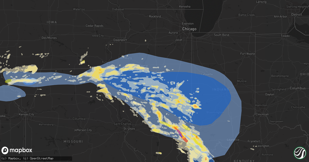
Hail Map in Illinois on June 29, 2023
Get this storm
June 29 map
$229
one time, instant access
Download today. No call, no setup
Keep the $229
Bought the map and want the full workflow? Apply the entire $229 to a subscription within 7 days. None of it is wasted.
Every map, not just this one
This buys you this map. Subscription and you get every map we run, in the markets you choose from a few cities to whole states to nationwide. Plus real-time alerts the moment a storm fires.
Contact data
Name, contact info, occupancy, even credit band for addresses in the footprint. You go from where it hit to who to call.
Become the source they trust
Unlimited branding weather history reports on demand. You already have the documented answer ready for the property owner, and you are the one who showed up with it.
Property data and RoofTrace estimates
Pull up any address you have got, its value and the exact code rules for that jurisdiction, straight from One Click Code. Then RoofTrace estimates the squares, pitch, and roof value, priced the way you price.
Storm reports in Illinois
Illinois
| Date | Description |
|---|---|
| 06/29/20236:54 PM CDT | A local report indicates 2.00 inch wind near 5 SSE Noble |
| 06/29/20236:54 PM CDT | A local report indicates 2.00 inch wind near 5 SSE Noble |
| 06/29/20236:50 PM CDT | A local report indicates 1.75 inch wind near 3 SW Noble |
| 06/29/20236:45 PM CDT | Report from mping: quarter |
| 06/29/20236:45 PM CDT | Report from mping: quarter |
| 06/29/20233:44 PM CDT | Communication tower bent over. Winds estimated around 120 mph. |
| 06/29/20233:35 PM CDT | Quarter sized hail. |
| 06/29/20233:35 PM CDT | Quarter to nearly half dollar sized hail. |
| 06/29/20233:09 PM CDT | Report of multiple trees down. |
| 06/29/20232:25 PM CDT | Report from mping: trees uprooted or snapped. |
| 06/29/20232:21 PM CDT | A local report indicates 70 MPH wind near Lawrenceville Airport |
| 06/29/20232:18 PM CDT | A tree and power lines were blown down. |
| 06/29/20232:15 PM CDT | Power line down. Time estimated from radar. |
| 06/29/20232:13 PM CDT | Report from mping: quarter |
| 06/29/20232:08 PM CDT | A local report indicates 1.00 inch wind near 1 NW Junction City |
| 06/29/20232:02 PM CDT | Numerous tree branches were blown down and one home had shingles torn off the roof. |
| 06/29/20232:01 PM CDT | Power lines and trees reported downed across town. |
| 06/29/20231:57 PM CDT | Power lines down. |
| 06/29/20231:55 PM CDT | Delayed report. Numerous tree limbs and power lines down. |
| 06/29/20231:50 PM CDT | Large tree snapped onto power poles. |
| 06/29/20231:50 PM CDT | Intersection of michigan and winter blocked by downed trees. |
| 06/29/20231:50 PM CDT | Tree fell on vehicle... No injuries. |
| 06/29/20231:50 PM CDT | Tree down on vehicle... Trapping two people. |
| 06/29/20231:50 PM CDT | Swop report. |
| 06/29/20231:50 PM CDT | Delayed report. Roof damage to business on south side of danville. Time estimated by radar. |
| 06/29/20231:48 PM CDT | Several trees were blown down... Including one that fell onto a house. |
| 06/29/20231:48 PM CDT | Power lines down. |
| 06/29/20231:47 PM CDT | A local report indicates 70 MPH wind near 3 NE Henning |
| 06/29/20231:45 PM CDT | Delayed report. Tree snapped... And a farm outbuilding sustained significant damage from wind. Time estimated by radar. |
| 06/29/20231:45 PM CDT | Delayed report. Camper flipped and rolled into other vehicles. Time estimated by radar. |
| 06/29/20231:45 PM CDT | Trees down on homes. |
| 06/29/20231:45 PM CDT | Trees down blocking roads. |
| 06/29/20231:45 PM CDT | Delayed report. Backyard fence blown down. Time estimated by radar. |
| 06/29/20231:45 PM CDT | Memorial bridge |
| 06/29/20231:45 PM CDT | Delayed report. Large tree limb down onto house. Time estimated by radar. |
| 06/29/20231:45 PM CDT | Trees down on homes. |
| 06/29/20231:40 PM CDT | Delayed report. Grain bins damaged. Time estimated by radar. |
| 06/29/20231:40 PM CDT | Delayed report. Tree limb down causing roof damage. Time estimated by radar. |
| 06/29/20231:40 PM CDT | Multiple trees down on buildings... Some people trapped. |
| 06/29/20231:40 PM CDT | Delayed report. Grain bin destroyed. Time estimated by radar. |
| 06/29/20231:37 PM CDT | Trees down... Two of which are on houses. Phone and cable lines down. |
| 06/29/20231:35 PM CDT | Trees and power lines down. |
| 06/29/20231:35 PM CDT | Delayed report. Large tree limb... Approximately 12 inches in diameter... Down in potomac. Time estimated by radar. |
| 06/29/20231:35 PM CDT | Delayed report. Large tree snapped and power poles blown down. Time estimated by radar. |
| 06/29/20231:35 PM CDT | Report from mping: 3-inch tree limbs broken. |
| 06/29/20231:35 PM CDT | Delayed report. Numerous large tree limbs down. Time estimated by radar. |
| 06/29/20231:35 PM CDT | Delayed report. 14 inch diameter tree blown down. Time estimated by radar. |
| 06/29/20231:35 PM CDT | Trees and power lines down. |
| 06/29/20231:35 PM CDT | Damage to county courthouse. Relayed via wthi-tv. |
| 06/29/20231:35 PM CDT | Trees and power lines down. |
| 06/29/20231:35 PM CDT | Report from mping: trees uprooted or snapped. |
| 06/29/20231:35 PM CDT | Delayed report. Several large trees 2 ft in diameter snapped and uprooted near bent tree golf course along lincoln highway rd. |
| 06/29/20231:34 PM CDT | Private weather station kilpaxto133 recorded 62mph gust on the west side of paxton. |
| 06/29/20231:33 PM CDT | Mesonet station up806 3 sw royal. |
| 06/29/20231:33 PM CDT | Power lines and trees reported downed throughout paxton. |
| 06/29/20231:32 PM CDT | Spotter estimates 80 mph wind gusts with large tree down in front lawn. |
| 06/29/20231:32 PM CDT | Trees down. Swop report. |
| 06/29/20231:30 PM CDT | Delayed report. Large tree blown down. Time estimated by radar. |
| 06/29/20231:30 PM CDT | Multiple large trees 1 to 2 foot in diameter snapped. |
| 06/29/20231:30 PM CDT | Report from mping: 3-inch tree limbs broken. |
| 06/29/20231:30 PM CDT | Numerous trees down near homer lake. |
| 06/29/20231:30 PM CDT | Extensive tree damage reported. |
| 06/29/20231:30 PM CDT | A local report indicates 75 MPH wind near 2 NW Sidney |
| 06/29/20231:30 PM CDT | Delayed report. Several tree limbs down... Resulting in structural damage including broken windows and a destroyed chain link fence. Time estimated by radar. |
| 06/29/20231:30 PM CDT | Delayed report. Numerous tree limbs and power lines down. |
| 06/29/20231:30 PM CDT | Delayed report. Several tree limbs down. Time estimated by radar. |
| 06/29/20231:30 PM CDT | Delayed report. Tree snapped near base. Time estimated by radar. |
| 06/29/20231:30 PM CDT | Delayed report. Large tree limb onto vehicle. Time estimated by radar. |
| 06/29/20231:30 PM CDT | Delayed report. Large tree limb down. Time estimated by radar. |
| 06/29/20231:30 PM CDT | Corrects previous tstm wnd dmg report from saint joseph power poles down... Large tree split at the base... And tree limbs broken. |
| 06/29/20231:30 PM CDT | Delayed report. Numerous tree limb and a few mid-sized trees down. Several streets closed due to debris. Swop report. Time estimated by radar. |
| 06/29/20231:30 PM CDT | Crops damaged. |
| 06/29/20231:25 PM CDT | A tree was blown down. |
| 06/29/20231:25 PM CDT | Delayed report. Power line down... Blocking glover street. Time estimated by radar. |
| 06/29/20231:25 PM CDT | Extensive tree damage across neoga... With some trees down on houses and residents trapped inside. |
| 06/29/20231:25 PM CDT | Delayed report. Several branches down onto a roof. Time estimated by radar. |
| 06/29/20231:25 PM CDT | Severe damage to trees. |
| 06/29/20231:25 PM CDT | Power lines down on south mattis avenue. Time estimated by radar. |
| 06/29/20231:25 PM CDT | Report from mping: 3-inch tree limbs broken. |
| 06/29/20231:24 PM CDT | Spotter reported numerous trees and limbs down with winds increasing and visibility near 0. |
| 06/29/20231:22 PM CDT | Large tree limb down. |
| 06/29/20231:20 PM CDT | Report from mping: 3-inch tree limbs broken. |
| 06/29/20231:20 PM CDT | Large trees down in campustown. |
| 06/29/20231:20 PM CDT | Delayed report. Numerous tree limbs down. Time estimated by radar. |
| 06/29/20231:20 PM CDT | Several tree limbs down... Some blocking roadways. Light pole also blown down on west john st. |
| 06/29/20231:20 PM CDT | Power lines down and tree damage. |
| 06/29/20231:20 PM CDT | Corrects previous tstm wnd dmg report from sidney. Power lines down and tree damage. Grain storage facility collapsed. |
| 06/29/20231:20 PM CDT | Delayed report. Large tree and several limbs down... Resulting in some structural damage and destroying a fence. Time estimated by radar. |
| 06/29/20231:20 PM CDT | Delayed report. Large tree limb... Approximately 12 to 18 inches in diameter... Down through roof of house. Time estimated by radar. |
| 06/29/20231:20 PM CDT | Delayed report. Big tree blown down... Destroying backyard playground equipment. Time estimated by radar. |
| 06/29/20231:20 PM CDT | Delayed report. Corn flattened. Time estimated by radar. |
| 06/29/20231:20 PM CDT | Delayed report. Numerous tree limbs down and shingles peeled off. Time estimated by radar. |
| 06/29/20231:18 PM CDT | A local report indicates 62 MPH wind near Willard Airport |
| 06/29/20231:18 PM CDT | Trees reported downed... Along with areas of water on roadways. |
| 06/29/20231:17 PM CDT | Large trees snapped and corn flattened. |
| 06/29/20231:16 PM CDT | Large tree snapped off on tomaras ave. |
| 06/29/20231:16 PM CDT | Delayed report. Widespread tree damage at lake of the woods golf course... Including large trees down. |
| 06/29/20231:16 PM CDT | Mesonet station cw2101 mahomet. |
| 06/29/20231:16 PM CDT | Portion of the terminal roof was ripped off... Causing airport closure. Via wcia-tv. |
| 06/29/20231:16 PM CDT | Large tree branch broken off. |
| 06/29/20231:16 PM CDT | A local report indicates 79 MPH wind near Willard Airport |
| 06/29/20231:16 PM CDT | Delayed report. Heavy tree damage and some power poles down. Swop report. |
| 06/29/20231:15 PM CDT | Large tree uprooted on grange dr. |
| 06/29/20231:15 PM CDT | Semi overturned on i-57 near the curtis rd. Exit. |
| 06/29/20231:15 PM CDT | Delayed report. Numerous tree limbs and power lines down. Time estimated by radar. |
| 06/29/20231:15 PM CDT | Large trees snapped near the base. |
| 06/29/20231:15 PM CDT | Delayed report. Large tree limb and old barn roof destroyed. Time estimated. |
| 06/29/20231:15 PM CDT | Several semis overturned on i-57. |
| 06/29/20231:15 PM CDT | Widespread tree damage... With numerous trees down on houses and cars. |
| 06/29/20231:14 PM CDT | A local report indicates 61 MPH wind near 1 NE Lake of the Woods |
| 06/29/20231:12 PM CDT | Several power poles down on us-45... Cornfields flattened... Large tree branches down at east side park. |
| 06/29/20231:10 PM CDT | Power lines down near pierron. Time estimated from radar. |
| 06/29/20231:10 PM CDT | Delayed report. Mature trees blown down... Six inch diameter tree limbs snapped. Time estimated by radar. |
| 06/29/20231:10 PM CDT | Delayed report. Tree limbs down. |
| 06/29/20231:10 PM CDT | Delayed report. Multiple large trees snapped and rv blown onto its side. Time estimated by radar. |
| 06/29/20231:07 PM CDT | Large tree down... Landed on two vehicles. |
| 06/29/20231:05 PM CDT | Shingles damaged at hotel in farmer city. |
| 06/29/20231:05 PM CDT | Many large tree branches blown down from healthy trees. |
| 06/29/20231:05 PM CDT | Widespread tree damage... With numerous trees down on houses and garages. |
| 06/29/20231:05 PM CDT | Trees blown down on homes... Causing damage to structures. Wind also blew shingles off houses. |
| 06/29/20231:00 PM CDT | Delayed report. Several large tree branches down along christmas tree road. Time estimated by radar. |
| 06/29/20231:00 PM CDT | Multiple trees down on top of homes. |
| 06/29/20231:00 PM CDT | Trees were blown down... Blocking all entrances to the 4-h memorial camp. |
| 06/29/20231:00 PM CDT | Report from mping: 3-inch tree limbs broken. |
| 06/29/202312:59 PM CDT | Corrects previous tstm wnd dmg report from sorento. Phone line was reported down near sorento. Time estimated from radar. |
| 06/29/202312:58 PM CDT | A local report indicates 60 MPH wind near Le Roy |
| 06/29/202312:58 PM CDT | Report from mping: 3-inch tree limbs broken. |
| 06/29/202312:55 PM CDT | Report from mping: 3-inch tree limbs broken. |
| 06/29/202312:55 PM CDT | Several large tree branches down. |
| 06/29/202312:55 PM CDT | Delayed report. Several three inch diameter limbs down. Some power lines downed due to the tree limbs. Time estimated by radar. |
| 06/29/202312:55 PM CDT | Several tree limbs blown down. Time estimated by radar. |
| 06/29/202312:55 PM CDT | Report from mping: trees uprooted or snapped. |
| 06/29/202312:54 PM CDT | A local report indicates 75 MPH wind near Decatur Airport |
| 06/29/202312:52 PM CDT | Report from mping: 3-inch tree limbs broken. |
| 06/29/202312:50 PM CDT | Large tree branch down on corner of lucile ave and highway 51. |
| 06/29/202312:50 PM CDT | Power pole leaning. |
| 06/29/202312:50 PM CDT | A local report indicates 60 MPH wind near Heyworth |
| 06/29/202312:50 PM CDT | Downed tree took out power lines near enterprise school. |
| 06/29/202312:50 PM CDT | Delayed report. Lots of tree and structural damage. Time estimated by radar. |
| 06/29/202312:50 PM CDT | Delayed report. Report from mping: 3-inch tree limbs broken. Time estimated by radar. |
| 06/29/202312:50 PM CDT | Trees down. |
| 06/29/202312:50 PM CDT | Report from mping: 3-inch tree limbs broken. |
| 06/29/202312:50 PM CDT | Four inch diameter tree limb down off of healthy tree... West of millikin university. Time estimated by radar. |
| 06/29/202312:50 PM CDT | Multiple trees down. |
| 06/29/202312:50 PM CDT | Three inch diameter branch snapped. Time estimated by radar. |
| 06/29/202312:46 PM CDT | Numerous trees and tree branches were blown down. |
| 06/29/202312:45 PM CDT | A tree and several tree branches were blown down. |
| 06/29/202312:45 PM CDT | Multiple trees down. |
| 06/29/202312:45 PM CDT | Multiple trees down. |
| 06/29/202312:45 PM CDT | Several tree branches were blown down. |
| 06/29/202312:45 PM CDT | Delayed report. Multiple four to five inch tree limbs down. Time estimated by radar. |
| 06/29/202312:45 PM CDT | Report from mping: 3-inch tree limbs broken. |
| 06/29/202312:45 PM CDT | Numerous trees and power lines were blown down. |
| 06/29/202312:44 PM CDT | A tree was blown over onto a house on van buren street. |
| 06/29/202312:43 PM CDT | Reports of trees and power lines down throughout montgomery county... With the greatest damage in litchfield extending northeastward to nokomis. Time of arrival in litc |
| 06/29/202312:42 PM CDT | A local report indicates 60 MPH wind near Litchfield |
| 06/29/202312:41 PM CDT | Nws employee reports several large tree branches down throughout normal. |
| 06/29/202312:41 PM CDT | Highway 10 was closed west of clinton due to downed trees and power lines. |
| 06/29/202312:41 PM CDT | Highway 10 was il 3971 8880 multiple trees down on top of homes. |
| 06/29/202312:41 PM CDT | Tree limbs down. |
| 06/29/202312:40 PM CDT | Several tree limbs down in town. |
| 06/29/202312:40 PM CDT | A 20 foot long aluminum flagpole was snapped off near base. |
| 06/29/202312:40 PM CDT | Areas of corn flattened. |
| 06/29/202312:40 PM CDT | Large tree broken along us-136. |
| 06/29/202312:40 PM CDT | Report from mping: 3-inch tree limbs broken; power poles broken. |
| 06/29/202312:40 PM CDT | Numerous large trees were blown down... Including one that crashed through the roof of a garage. |
| 06/29/202312:40 PM CDT | Power lines down. |
| 06/29/202312:38 PM CDT | Large branches down... Gutters and shingles blown off. |
| 06/29/202312:38 PM CDT | A shed was destroyed and several trees were damaged at the intersection of thorps road and north 100 east road. |
| 06/29/202312:38 PM CDT | Shingle damage and small limbs down. |
| 06/29/202312:36 PM CDT | A few large tree branches were blown down. |
| 06/29/202312:36 PM CDT | A local report indicates 60 MPH wind near 2 N Gillespie |
| 06/29/202312:36 PM CDT | A few large tr349) 1830 w 0 charleston coles il 3948 8818 delayed report. Numerous tree limb and a few mid-sized trees down. Several str |
| 06/29/202312:35 PM CDT | Power lines down on i-55 near mile marker 133... Prompting some road closures. |
| 06/29/202312:35 PM CDT | Emergency manager reports trees through houses across northeastern third of christian county. 2 barns were also destroyed. |
| 06/29/202312:35 PM CDT | Large tree limbs down along highway 10 just west of midland city. |
| 06/29/202312:34 PM CDT | Tree limbs down. |
| 06/29/202312:33 PM CDT | 70 year old tree snapped in half and crashed into the roof of a modular home. |
| 06/29/202312:30 PM CDT | 7 to 8 power poles were blown down at i-55 exit 133 just north of lincoln. Power lines were draped across the bridge that goes over route 66. |
| 06/29/202312:30 PM CDT | Roof blown off of outbuilding. |
| 06/29/202312:30 PM CDT | Many power lines down along route 121. |
| 06/29/202312:30 PM CDT | Many power lines down in lincoln. |
| 06/29/202312:30 PM CDT | Large tree branches down. |
| 06/29/202312:30 PM CDT | Tree fell onto residence causing significant damage. |
| 06/29/202312:30 PM CDT | Large tree broken along 1400th ave... And several tree branches down along airport rd. |
| 06/29/202312:30 PM CDT | A large tree was blown down. |
| 06/29/202312:30 PM CDT | Grain bins were damaged along us-136. |
| 06/29/202312:29 PM CDT | Numerous tree branches down. |
| 06/29/202312:28 PM CDT | Reports of trees down along beltrees road east of elsah. |
| 06/29/202312:27 PM CDT | A local report indicates 60 MPH wind near 1 NNW Lincoln |
| 06/29/202312:27 PM CDT | Two foot diameter tree blown down. Shingles blown off apartment complex. Possibly caused by tornado. Time estimated by radar. |
| 06/29/202312:26 PM CDT | Corn crops laying over. |
| 06/29/202312:25 PM CDT | Extensive tree damage in dawson with numerous roads blocked by debris. Time estimated by radar. |
| 06/29/202312:24 PM CDT | Reports of trees down along hagen road south of jerseyville. |
| 06/29/202312:24 PM CDT | Report from mping: 3-inch tree limbs broken. T closed west of clinton due to downed trees and power lines. |
| 06/29/202312:24 PM CDT | Report from mping: 3-inch tree limbs broken. Time estimated by radar. |
| 06/29/202312:20 PM CDT | Large tree limbs down at intersection of spring and edwards in springfield. |
| 06/29/202312:20 PM CDT | Camper rolled into a house... With shingles blown off the house. Possibly caused by a tornado. |
| 06/29/202312:20 PM CDT | Large trees down. |
| 06/29/202312:20 PM CDT | Large tree blown down onto a chain link fence... Destroying the fence. Time estimated by radar. |
| 06/29/202312:20 PM CDT | Trees uprooted and power lines down. Possibly caused by a tornado. |
| 06/29/202312:20 PM CDT | Several large trees down. Several houses with shingle damage. Possibly caused by a tornado. Time estimated by radar. |
| 06/29/202312:20 PM CDT | Substantial roof damage |
| 06/29/202312:20 PM CDT | Several large tree branches down. Time estimated from radar. |
| 06/29/202312:20 PM CDT | Trash dumpster downtown blown into a window... Causing it to shatter. |
| 06/29/202312:19 PM CDT | Two trees were blown over. Irport champaign il 4004 8827 portion of the terminal roof was ripped off... Causing airport closure. Via wc |
| 06/29/202312:19 PM CDT | Two trees were blown over. |
| 06/29/202312:18 PM CDT | Report from mping: trees uprooted or snapped. Possibly caused by a tornado. |
| 06/29/202312:17 PM CDT | A local report indicates 61 MPH wind near Capital Airport |
| 06/29/202312:15 PM CDT | Trees and power lines down throughout the county north of highway 16. At virden... Live power lines were down across a residence. Time represents beginning of damage in |
| 06/29/202312:15 PM CDT | Five inch diameter tree branch snapped. Time estimated by radar. |
| 06/29/202312:15 PM CDT | At least 15 power poles down. Time estimated by radar. |
| 06/29/202312:15 PM CDT | Report from mping: 3-inch tree limbs broken. Time estimated by radar. |
| 06/29/202312:15 PM CDT | One foot diameter tree snapped in half... Just north of i-72. |
| 06/29/202312:15 PM CDT | Tree down on a car and power lines. Time estimated by radar. |
| 06/29/202312:15 PM CDT | A home was heavily damaged on curran road south of county road 5 1/2 south. Possibly caused by a tornado. |
| 06/29/202312:15 PM CDT | Six to eight inch diameter branch blown off of healthy tree... Blocking crestwood drive. |
| 06/29/202312:15 PM CDT | Large tree down blocking subdivision road. |
| 06/29/202312:15 PM CDT | Major structural damage with significant roof loss. Possibly caused by a tornado. |
| 06/29/202312:15 PM CDT | A local report indicates 60 MPH wind near 1 SSW Morton |
| 06/29/202312:15 PM CDT | A large tree branch was blown down. |
| 06/29/202312:14 PM CDT | A local report indicates 60 MPH wind near 3 SSW Morton |
| 06/29/202312:10 PM CDT | Delayed report. Report from mping: trees uprooted or snapped. Time estimated by radar. |
| 06/29/202312:10 PM CDT | A local report indicates 60 MPH wind near 4 W Washington |
| 06/29/202312:07 PM CDT | Large tree blown over... Approximately 18 inches in diameter. Time estimated by radar. |
| 06/29/202312:07 PM CDT | Large branch down... Approximately five inches in diameter. |
| 06/29/202312:05 PM CDT | A tree was blown down across the street from holy family school. |
| 06/29/202312:05 PM CDT | A local report indicates 60 MPH wind near 3 SW Groveland |
| 06/29/202312:05 PM CDT | 5 to 8 inch tree limbs snapped near salisbury... And one tree uprooted. |
| 06/29/202312:05 PM CDT | Reported at fondulac park. |
| 06/29/202312:05 PM CDT | A large tree and several tree branches were blown down in pekin park. |
| 06/29/202312:03 PM CDT | A local report indicates 62 MPH wind near Bellevue |
| 06/29/202312:02 PM CDT | Swop member reported 8-10 power poles snapped along dirksen pkwy from thunderstorm winds. |
| 06/29/202311:57 AM CDT | Trees reported down throughout the county. In white hall... There were a few power lines brought down as well. Time of arrival at white hall estimated from radar. |
| 06/29/202311:55 AM CDT | Large tree snapped about half way up trunk. |
| 06/29/202311:55 AM CDT | Large tree snapped about half way up trunk. Ime estimated by radar. |
| 06/29/202311:54 AM CDT | Machine shed partially collapsed at the intersection of old airport rd. And sheehan rd. |
| 06/29/202311:54 AM CDT | Machine shed partially collapsed at the intersection of old airport rd. And sheehan rd. |
| 06/29/202311:54 AM CDT | Wind gust measured on mobile anemometer between galesburg and wataga. Some corn stalks bent over. |
| 06/29/202311:54 AM CDT | Several branches down. |
| 06/29/202311:53 AM CDT | Numerous reports of trees and power lines down throughout the county north of 2 miles south of hardin. |
| 06/29/202311:53 AM CDT | Corrects location. Tree down near interstate 280 near quad cities international airport. Time estimated from radar. |
| 06/29/202311:53 AM CDT | Tree down near interstate 280 near quad cities international airport. Time estimated from radar. |
| 06/29/202311:52 AM CDT | Tree down on a truck. |
| 06/29/202311:52 AM CDT | A large tree branch was blown down. |
| 06/29/202311:52 AM CDT | Delayed report. Numerous tree limbs down. |
| 06/29/202311:50 AM CDT | Delayed report. Large tree down... Destroying a trampoline. Time estimated by radar. |
| 06/29/202311:50 AM CDT | Delayed report. Trees down. A few fallen limbs took out power lines. |
| 06/29/202311:45 AM CDT | A large tree was snapped. |
| 06/29/202311:43 AM CDT | Several trees down across town with 2 ft diameter or greater. Roof damage to multiple homes. |
| 06/29/202311:43 AM CDT | Small trees down at intersection of highway 41 and 116. |
| 06/29/202311:40 AM CDT | One foot diameter tree limb down... Causing damage to patio furniture. Time estimated by radar. |
| 06/29/202311:40 AM CDT | Delayed report. Trees uprooted... Power lines downed... And window ac unit blown into home. Time estimated. |
| 06/29/202311:40 AM CDT | Report from mping: 1-inch tree limbs broken; shingles blown off. |
| 06/29/202311:40 AM CDT | A local report indicates 60 MPH wind near Canton |
| 06/29/202311:37 AM CDT | Tree down north of monmouth on hwy 67... Time estimated from radar. |
| 06/29/202311:36 AM CDT | Large tree... Approximately one foot in diameter... Down on east side of cuba. |
| 06/29/202311:35 AM CDT | A local report indicates 60 MPH wind near 2 W Cuba |
| 06/29/202311:35 AM CDT | A local report indicates 60 MPH wind near 1 WSW Fairview |
| 06/29/202311:35 AM CDT | 6 inch diameter tree snapped. Time estimated by radar. |
| 06/29/202311:35 AM CDT | Report from mping: 3-inch tree limbs broken; power poles broken. |
| 06/29/202311:35 AM CDT | Trees and power lines reported down throughout the county. Time of arrival at pittsfield estimated from radar. |
| 06/29/202311:35 AM CDT | Report of a few trees down near versailles. Time estimated from radar. |
| 06/29/202311:35 AM CDT | 8 to 10 inch tree limbs down in cuba. Time estimated by radar. |
| 06/29/202311:32 AM CDT | Trees and power lines reported down throughout the northern end of the county. Time of arrival at perry estimated from radar. |
| 06/29/202311:30 AM CDT | Report of lots of trees down in town... Including pictures relayed of metal roof peeled off of a shed. Time estimated by radar. |
| 06/29/202311:26 AM CDT | Railroad gate snapped off by strong winds. |
| 06/29/202311:25 AM CDT | Report from mping: 3-inch tree limbs broken; power poles broken. Time estimated from radar. |
| 06/29/202311:20 AM CDT | Corrects previous tstm wnd gst report from roseville. Several large tree branches snapped in roseville. Winds estimated near 100 mph. Time estimated from radar. |
| 06/29/202311:20 AM CDT | Numerous trees and power lines were blown down. |
| 06/29/202311:16 AM CDT | 88 mph measured wind gust. 15 minutes of gusts over 70 mph. Rv flipped. |
| 06/29/202311:16 AM CDT | Report from mping: 3-inch tree limbs broken; power poles broken. |
| 06/29/202311:16 AM CDT | Report from mping: 3-inch tree limbs broken; power poles broken. |
| 06/29/202311:16 AM CDT | A local report indicates 60 MPH wind near Camden |
| 06/29/202311:16 AM CDT | A local report indicates 60 MPH wind near Camden |
| 06/29/202311:15 AM CDT | Time estimated. Tree on house. Power lines down. |
| 06/29/202311:13 AM CDT | 80 plus mph wind... Mature evergreens snapped at base. |
| 06/29/202311:13 AM CDT | Corrects time of previous tstm wnd gst report from good hope. Several trees damaged and trunks snapped in good hope. Winds estimated near 100 mph. Time estimated from r |
| 06/29/202311:10 AM CDT | Reports of substantial tree damage around the wiu campus in macomb. Power lines are down... Some of which are still live. |
| 06/29/202311:09 AM CDT | Corrects time of previous tstm wnd gst report from 2 sw swan creek. Farm outbuilding destroyed. Winds estimated near 100 mph. Time estimated from radar. |
| 06/29/202311:05 AM CDT | Home weather station with a gust around 90 mph... Estimated up to 100. |
| 06/29/202311:05 AM CDT | Several tree trunks snapped. Winds estimated near 100 mph. Time estimated from radar. |
| 06/29/202311:03 AM CDT | A local report indicates 74 MPH wind near 4 SE Blandinsville |
| 06/29/202311:02 AM CDT | Trained spotter reported snapped power poles... Lots of trees down... And some barns blown over between durham and laharpe. Winds were estimated over 80 miles per hour. |
| 06/29/202311:00 AM CDT | Extensive tree damage throughout town. Winds were strong for about 20 minutes beginning around 11 am. Time estimated by radar. |
| 06/29/202311:00 AM CDT | Full size barn flattened to ground... Full size trees up rooted laying to the east. |
| 06/29/202310:58 AM CDT | Time estimated by radar. |
| 06/29/202310:58 AM CDT | Several tree trunks snapped near the twin oaks golf and country club. Winds estimated near 100 mph. Time estimated on radar. |
| 06/29/202310:56 AM CDT | Farm outbuilding destroyed... Winds estimated around 90-100 mph. Time estimated on radar. |
| 06/29/202310:55 AM CDT | Garage outbuilding destroyed... Winds estimated at 100 mph. Time estimated by radar. |
| 06/29/202310:54 AM CDT | Time estimated by radar. Two 18 inch diameter trees downed. Numerous tree blanches down. One of the worst storms experienced in 78 yrs. |
| 06/29/202310:53 AM CDT | Several trees across roadway. |
| 06/29/202310:50 AM CDT | 30 inch tree snapped at base. |
| 06/29/202310:45 AM CDT | Grain bin destroyed and rolled into field. Winds estimated at 100 mph. Time estimated based on radar. |
| 06/29/202310:44 AM CDT | Several power poles snapped near base. Estimated winds around 120 mph. |
| 06/29/202310:43 AM CDT | Roof ripped off of mobile home... Several injuries per em. Time estimated from radar. |
| 06/29/202310:40 AM CDT | Major tree damage reported throughout town. |
| 06/29/202310:38 AM CDT | Cannot see neighbors house. |
| 06/29/202310:30 AM CDT | Several large to very large tree branches down. Trees snapped as well. Time estimated by radar. |
| 06/29/202310:20 AM CDT | Several large tree branches snapped in roseville. Winds estimated near 100 mph. Time estimated from radar. |
| 06/29/202310:11 AM CDT | Farm outbuilding destroyed. Winds estimated near 100 mph. Time estimated from radar. |
| 06/29/202310:09 AM CDT | Several trees damaged and trunks snapped in good hope. Winds estimated near 100 mph. Time estimated from radar. |
| 06/29/20239:04 AM CDT | Report from mping: quarter |
| 06/29/20238:20 AM CDT | A local report indicates 1.00 inch wind near Petersburg |
| 06/29/20237:00 AM CDT | Time estimated by radar. |
| 06/28/20238:13 PM CDT | Report from mping: quarter |
| 06/28/20237:30 PM CDT | Delayed report. Report from mping: trees uprooted or snapped. Time estimated by radar. |
| 06/28/20237:27 PM CDT | Golfball size hail near the intersection of county road 350 and state rt 1. |
All States Impacted by Hail Map on June 29, 2023
Cities Impacted by Hail Map on June 29, 2023
- Frankfort, KS
- Blue Rapids, KS
- Marysville, KS
- Vermillion, KS
- Axtell, KS
- Hazleton, IN
- Patoka, IN
- Petersburg, IN
- Francisco, IN
- Urbana, IL
- Champaign, IL
- Philo, IL
- Tuscola, IL
- Charleston, IL
- Villa Grove, IL
- Hindsboro, IL
- Tolono, IL
- Camargo, IL
- Ashmore, IL
- Westfield, IL
- Craig, MO
- Falls City, NE
- Mound City, MO
- Rulo, NE
- Centralia, KS
- Baileyville, KS
- Corning, KS
- Oneida, KS
- Seneca, KS
- Sabetha, KS
- Bern, KS
- Wetmore, KS
- Goff, KS
- Oakland City, IN
- Winslow, IN
- Paris, IL
- Netawaka, KS
- Fairview, KS
- Powhattan, KS
- Morrill, KS
- Salem, NE
- Hiawatha, KS
- Whiting, KS
- Horton, KS
- White Cloud, KS
- Everest, KS
- Robinson, KS
- Dennison, IL
- Rock Port, MO
- Westboro, MO
- Tarkio, MO
- Fairfax, MO
- Pickering, MO
- Burlington Junction, MO
- Elmo, MO
- Sheridan, MO
- Clearmont, MO
- Parnell, MO
- Hopkins, MO
- Worth, MO
- Maryville, MO
- Grant City, MO
- Eagleville, MO
- Princeton, MO
- Ridgeway, MO
- Lucerne, MO
- Cainsville, MO
- Blythedale, MO
- Ravenwood, MO
- Denver, MO
- Martinsville, MO
- Skidmore, MO
- Pollock, MO
- Unionville, MO
- Albany, MO
- Spickard, MO
- Harris, MO
- Newtown, MO
- Milan, MO
- Bethany, MO
- Gentry, MO
- Galt, MO
- Clyde, MO
- Gilman City, MO
- New Hampton, MO
- Trenton, MO
- Conception Junction, MO
- Stanberry, MO
- Humphreys, MO
- McFall, MO
- Barnard, MO
- Coffey, MO
- Pattonsburg, MO
- Darlington, MO
- Jamesport, MO
- Conception, MO
- Guilford, MO
- Maysville, MO
- Bolckow, MO
- King City, MO
- Jameson, MO
- Graham, MO
- Rosendale, MO
- Rea, MO
- Union Star, MO
- Savannah, MO
- Maitland, MO
- Fillmore, MO
- Forest City, MO
- Oregon, MO
- Muscotah, KS
- Holton, KS
- Effingham, KS
- Lancaster, KS
- Troy, KS
- Highland, KS
- Atchison, KS
- Rushville, MO
- Denton, KS
- Cummings, KS
- Bendena, KS
- Saint Joseph, MO
- De Kalb, MO
- Faucett, MO
- Wathena, KS
- Elwood, KS
- Amazonia, MO
- Cosby, MO
- Easton, MO
- Agency, MO
- Greentop, MO
- Queen City, MO
- Worthington, MO
- Kirksville, MO
- Novinger, MO
- Green City, MO
- La Plata, MO
- Green Castle, MO
- Decker, IN
- Vincennes, IN
- Allendale, IL
- Mount Carmel, IL
- Princeton, IN
- Cynthiana, IN
- Fort Branch, IN
- Owensville, IN
- Haubstadt, IN
- Poseyville, IN
- Evansville, IN
- Wadesville, IN
- Elberfeld, IN
- Henderson, KY
- Reed, KY
- Chandler, IN
- Robards, KY
- Boonville, IN
- Spottsville, KY
- Newburgh, IN
- Richland, IN
- Rockport, IN
- Lynnville, IN
- Owensboro, KY
- Tennyson, IN
- Maceo, KY
- Reynolds Station, KY
- Lewisport, KY
- Philpot, KY
- Hawesville, KY
- Chrisney, IN
- Gentryville, IN
- Grandview, IN
- Browning, MO
- Mercer, MO
- Calhoun, KY
- Bloomfield, IA
- Selma, IA
- Floris, IA
- Douds, IA
- Memphis, MO
- Downing, MO
- Brashear, MO
- Gibbs, MO
- Baring, MO
- Novelty, MO
- Edina, MO
- Rutledge, MO
- Hurdland, MO
- Whitesville, KY
- Fordsville, KY
- Utica, KY
- Sebree, KY
- Slaughters, KY
- Sacramento, KY
- Hanson, KY
- Rumsey, KY
- Hartford, KY
- Island, KY
- Livermore, KY
- Olaton, KY
- Falls Of Rough, KY
- Dundee, KY
- Horse Branch, KY
- Centertown, KY
- Arbela, MO
- Luray, MO
- Gorin, MO
- Wyaconda, MO
- Donnellson, IA
- Kahoka, MO
- Knox City, MO
- Farmington, IA
- Argyle, IA
- Monticello, MO
- La Belle, MO
- Alexandria, MO
- Saint Patrick, MO
- Revere, MO
- Canton, MO
- Lewistown, MO
- Wayland, MO
- Williamstown, MO
- Caneyville, KY
- Beaver Dam, KY
- Greenville, KY
- Madisonville, KY
- Rosine, KY
- Central City, KY
- Bremen, KY
- Rockport, KY
- Cromwell, KY
- Drakesboro, KY
- Graham, KY
- McHenry, KY
- Powderly, KY
- Terre Haute, IN
- Cory, IN
- Keokuk, IA
- Mendon, IL
- Loraine, IL
- Warsaw, IL
- Ursa, IL
- West Point, IL
- Sutter, IL
- Montrose, IA
- Fort Madison, IA
- Carthage, IL
- Elvaston, IL
- Wever, IA
- Hamilton, IL
- Basco, IL
- West Point, IA
- Nauvoo, IL
- Dallas City, IL
- Niota, IL
- La Prairie, IL
- Augusta, IL
- Golden, IL
- Plymouth, IL
- Tennessee, IL
- La Harpe, IL
- Bowen, IL
- Colchester, IL
- Macomb, IL
- Blandinsville, IL
- Littleton, IL
- Industry, IL
- Rushville, IL
- Raritan, IL
- Adair, IL
- Roseville, IL
- Smithshire, IL
- Bushnell, IL
- Lomax, IL
- Good Hope, IL
- Sciota, IL
- Vermont, IL
- Stronghurst, IL
- Media, IL
- Carman, IL
- Burlington, IA
- Beechmont, KY
- Beech Creek, KY
- Browder, KY
- Belton, KY
- Dunmor, KY
- Morgantown, KY
- Auburn, KY
- Rochester, KY
- Lewisburg, KY
- Russellville, KY
- Bowling Green, KY
- Jetson, KY
- Rockfield, KY
- Roundhill, KY
- Huntsville, IL
- Camden, IL
- Ipava, IL
- Marietta, IL
- Bardolph, IL
- Astoria, IL
- Prairie City, IL
- Browning, IL
- Table Grove, IL
- Ellisville, IL
- Gilson, IL
- Berwick, IL
- Cuba, IL
- Havana, IL
- Maquon, IL
- Lewistown, IL
- Saint Augustine, IL
- Smithfield, IL
- Abingdon, IL
- Cameron, IL
- Avon, IL
- Canton, IL
- London Mills, IL
- Bath, IL
- Farmington, IL
- Elmwood, IL
- Princeville, IL
- Yates City, IL
- Liverpool, IL
- Saint David, IL
- Glasford, IL
- Dunlap, IL
- Hanna City, IL
- Edwards, IL
- Trivoli, IL
- Bryant, IL
- Brimfield, IL
- Fairview, IL
- Norris, IL
- Mapleton, IL
- Green Valley, IL
- Mason City, IL
- Pekin, IL
- Peoria, IL
- Forest City, IL
- Kingston Mines, IL
- San Jose, IL
- Easton, IL
- Manito, IL
- Kilbourne, IL
- Topeka, IL
- Coatsburg, IL
- Camp Point, IL
- Timewell, IL
- Clayton, IL
- Mount Sterling, IL
- Chandlerville, IL
- Beardstown, IL
- Frederick, IL
- Virginia, IL
- Ashland, IL
- Greenview, IL
- Petersburg, IL
- Sherman, IL
- Arenzville, IL
- Cantrall, IL
- Tallula, IL
- Oakford, IL
- Athens, IL
- Pleasant Plains, IL
- Springfield, IL
- Olmstead, KY
- Sharon Grove, KY
- Adairville, KY
- Springfield, TN
- Woodburn, KY
- Franklin, KY
- Scottsville, KY
- Westmoreland, TN
- Orlinda, TN
- Lafayette, TN
- Alvaton, KY
- Adolphus, KY
- Portland, TN
- Bethpage, TN
- Cross Plains, TN
- Elkton, KY
- Cedar Hill, TN
- Whites Creek, TN
- White House, TN
- Gallatin, TN
- Cottontown, TN
- Goodlettsville, TN
- Joelton, TN
- Hendersonville, TN
- Greenbrier, TN
- Lebanon, TN
- Castalian Springs, TN
- Mount Juliet, TN
- Hartsville, TN
- Riddleton, TN
- Dixon Springs, TN
- Carthage, TN
- Madison, TN
- Pleasant Shade, TN
- La Grange, MO
- Quincy, IL
- Fowler, IL
- Paloma, IL
- Baylis, IL
- Liberty, IL
- Griggsville, IL
- Chambersburg, IL
- Meredosia, IL
- Versailles, IL
- Perry, IL
- Winchester, IL
- Concord, IL
- Bluffs, IL
- Jacksonville, IL
- Chapin, IL
- Alexander, IL
- Waverly, IL
- New Berlin, IL
- Auburn, IL
- Loami, IL
- Franklin, IL
- Chatham, IL
- Murrayville, IL
- Woodson, IL
- Barry, IL
- Pittsfield, IL
- New Salem, IL
- Waggoner, IL
- Modesto, IL
- Glenarm, IL
- Farmersville, IL
- Roodhouse, IL
- Palmyra, IL
- Girard, IL
- Divernon, IL
- Virden, IL
- Thayer, IL
- Galesburg, IL
- Monmouth, IL
- Kirkwood, IL
- Gladstone, IL
- Biggsville, IL
- Williamsfield, IL
- Oneida, IL
- Victoria, IL
- Knoxville, IL
- Dahinda, IL
- Laura, IL
- East Galesburg, IL
- Henderson, IL
- Wyoming, IL
- La Fayette, IL
- Alexis, IL
- Altona, IL
- Wataga, IL
- Galva, IL
- Speer, IL
- Toulon, IL
- Washington, IL
- Henry, IL
- Sparland, IL
- Delavan, IL
- Creve Coeur, IL
- Mossville, IL
- Groveland, IL
- South Pekin, IL
- Bradford, IL
- Peoria Heights, IL
- East Peoria, IL
- Lacon, IL
- Edelstein, IL
- Tremont, IL
- Morton, IL
- Metamora, IL
- Chillicothe, IL
- Lowpoint, IL
- Washburn, IL
- McLean, IL
- Deer Creek, IL
- Congerville, IL
- Stanford, IL
- Williamsville, IL
- New Holland, IL
- Lawndale, IL
- Carlock, IL
- Clinton, IL
- Varna, IL
- Hartsburg, IL
- Mackinaw, IL
- Hopedale, IL
- Beason, IL
- Danvers, IL
- Mount Pulaski, IL
- Emden, IL
- Armington, IL
- Lincoln, IL
- Elkhart, IL
- Goodfield, IL
- Atlanta, IL
- Waynesville, IL
- Middletown, IL
- Roanoke, IL
- Minier, IL
- Kenney, IL
- Bloomington, IL
- Shirley, IL
- Eureka, IL
- Chestnut, IL
- Maroa, IL
- Dawson, IL
- Edinburg, IL
- Latham, IL
- Rochester, IL
- Harristown, IL
- Mount Auburn, IL
- Stonington, IL
- Taylorville, IL
- Buffalo, IL
- Bulpitt, IL
- Decatur, IL
- Mechanicsburg, IL
- Kincaid, IL
- Warrensburg, IL
- Riverton, IL
- Pawnee, IL
- Tovey, IL
- Morrisonville, IL
- Niantic, IL
- Illiopolis, IL
- Blue Mound, IL
- Old Hickory, TN
- Nashville, TN
- Hermitage, TN
- Watertown, TN
- Normal, IL
- Benson, IL
- El Paso, IL
- Hudson, IL
- La Rose, IL
- Dana, IL
- Rutland, IL
- Secor, IL
- Gridley, IL
- Heyworth, IL
- Toluca, IL
- Minonk, IL
- Nokomis, IL
- Harvel, IL
- Witt, IL
- Palmer, IL
- Pana, IL
- Raymond, IL
- Owaneco, IL
- Tower Hill, IL
- Mt Zion, IL
- Forsyth, IL
- Lakewood, IL
- Shelbyville, IL
- Assumption, IL
- Le Roy, IL
- Bethany, IL
- Oconee, IL
- Ramsey, IL
- Herrick, IL
- Downs, IL
- Boody, IL
- Lane, IL
- Wapella, IL
- Macon, IL
- Beecher City, IL
- Moweaqua, IL
- Towanda, IL
- Lexington, IL
- Cowden, IL
- Oreana, IL
- Argenta, IL
- Findlay, IL
- Rosamond, IL
- Ohlman, IL
- Dalton City, IL
- Bingham, IL
- Saint Elmo, IL
- Altamont, IL
- Bonaparte, IA
- Mount Sterling, IA
- Du Bois, NE
- Cameron, MO
- Mount Vernon, IN
- Illinois City, IL
- Muscatine, IA
- Hannibal, MO
- Lawrenceville, IL
- Patterson, IL
- Pearl, IL
- White Hall, IL
- Hillview, IL
- Monroe City, MO
- Hunnewell, MO
- Lewis, IA
- Atlantic, IA
- Robinson, IL
- Flat Rock, IL
- Powersville, MO
- Palmyra, MO
- Farmersburg, IN
- Gallatin, MO
- Olney, IL
- Golden Gate, IL
- Milton, IA
- Shelbyville, MO
- Emden, MO
- Crossville, IL
- Moulton, IA
- Marshall, IL
- Kansas, IL
- Brazil, IN
- Redmon, IL
- Oakland, IL
- Brocton, IL
- Glenwood, MO
- Livonia, MO
- Earlington, KY
- Casey, IL
- Home, KS
- Onaga, KS
- Kinderhook, IL
- Hull, IL
- Taylor, MO
- New Canton, IL
- Payson, IL
- Plainville, IL
- Rockport, IL
- Crofton, KY
- Dawson Springs, KY
- Saint Charles, KY
- Altamont, MO
- Oaktown, IN
- Wiota, IA
- Cumberland, IA
- Sumner, IL
- Monroe City, IN
- Pimento, IN
- Lewis, IN
- Clay City, IN
- Otwell, IN
- Jasper, IN
- Stendal, IN
- Allensville, KY
- Hopkinsville, KY
- Carmi, IL
- Pleasant Hill, IL
- Agency, IA
- Batavia, IA
- Packwood, IA
- Eldon, IA
- Fairfield, IA
- Martinsville, IL
- Frankford, MO
- New London, MO
- West York, IL
- Fairbanks, IN
- Sullivan, IN
- West Union, IL
- Grayville, IL
- Newman, IL
- New Harmony, IN
- New Haven, IL
- Kidder, MO
- Annapolis, IL
- Nebo, KY
- Manitou, KY
- Carlinville, IL
- Greenfield, IL
- Hettick, IL
- Chesterfield, IL
- Keosauqua, IA
- Dale, IN
- Fairfield, IL
- Cisne, IL
- Geff, IL
- Spurgeon, IN
- Parkersburg, IL
- Hutsonville, IL
- Arthur, IL
- Atwood, IL
- Arcola, IL
- Lovington, IL
- Hammond, IL
- West Terre Haute, IN
- Bridgeport, IL
- Percival, IA
- Union, NE
- Henderson, IA
- Macedonia, IA
- Hamilton, MO
- Saint Francisville, IL
- Keota, IA
- Calhoun, IL
- Nortonville, KY
- Albion, IL
- West Salem, IL
- Breckenridge, MO
- Shelburn, IN
- Kane, IL
- Fieldon, IL
- Sullivan, IL
- Corydon, KY
- Mortons Gap, KY
- Humboldt, IL
- Medora, IL
- Shipman, IL
- Dixon, KY
- White Plains, KY
- Lerna, IL
- Oblong, IL
- Toledo, IL
- Greenup, IL
- Palestine, IL
- Flanagan, IL
- Mode, IL
- Fisher, IL
- Forrest, IL
- Saunemin, IL
- Anchor, IL
- Bellflower, IL
- Cullom, IL
- Foosland, IL
- Pontiac, IL
- Cisco, IL
- Colfax, IL
- Windsor, IL
- De Land, IL
- Cropsey, IL
- Mahomet, IL
- Strasburg, IL
- Dewitt, IL
- Bement, IL
- Saybrook, IL
- Cooksville, IL
- Farmer City, IL
- Graymont, IL
- Chenoa, IL
- Fairbury, IL
- Mansfield, IL
- Strawn, IL
- Arrowsmith, IL
- Ellsworth, IL
- Monticello, IL
- Gibson City, IL
- Chatsworth, IL
- White Heath, IL
- Shumway, IL
- Weldon, IL
- Cerro Gordo, IL
- Milmine, IL
- La Place, IL
- Long Point, IL
- Sibley, IL
- Guthrie, KY
- Griffin, IN
- Trenton, KY
- Waverly, KY
- Burnt Prairie, IL
- Evanston, IN
- Norris City, IL
- Claremont, IL
- Providence, KY
- Holland, IN
- Lamar, IN
- Piper City, IL
- Odell, IL
- Litchfield, IL
- Nilwood, IL
- Irving, IL
- Butler, IL
- Fillmore, IL
- Coffeen, IL
- Taylor Springs, IL
- Hillsboro, IL
- Brownstown, IL
- Donnellson, IL
- Walshville, IL
- Mulberry Grove, IL
- Greenville, IL
- Sorento, IL
- Vandalia, IL
- Panama, IL
- Smithboro, IL
- Gillespie, IL
- Keyesport, IL
- Mount Olive, IL
- Sheldon, IL
- Gays, IL
- Armstrong, IL
- Ogden, IL
- Pesotum, IL
- Sadorus, IL
- Danforth, IL
- Loda, IL
- Gifford, IL
- Ivesdale, IL
- Savoy, IL
- Sidney, IL
- Stewardson, IL
- Buckley, IL
- Royal, IL
- Elliott, IL
- Gilman, IL
- Saint Joseph, IL
- Watseka, IL
- Crescent City, IL
- Onarga, IL
- Melvin, IL
- Rossville, IL
- Neoga, IL
- Seymour, IL
- Penfield, IL
- Thawville, IL
- Mattoon, IL
- Rantoul, IL
- Bondville, IL
- Hoopeston, IL
- Milford, IL
- Wellington, IL
- Rankin, IL
- Dewey, IL
- Potomac, IL
- Roberts, IL
- Ludlow, IL
- Paxton, IL
- Ashkum, IL
- Kempton, IL
- Thomasboro, IL
- Cissna Park, IL
- Kinmundy, IL
- Shobonier, IL
- Salem, IL
- Alma, IL
- Saint Peter, IL
- Vernon, IL
- Patoka, IL
- Sigel, IL
- Longview, IL
- Xenia, IL
- Homer, IL
- Montrose, IL
- Trilla, IL
- Jewett, IL
- Iuka, IL
- Broadlands, IL
- Teutopolis, IL
- Danville, IL
- Muncie, IL
- Dieterich, IL
- Rinard, IL
- Fairmount, IL
- Edgewood, IL
- Effingham, IL
- Oakwood, IL
- Mason, IL
- Murdock, IL
- Watson, IL
- Farina, IL
- Wheeler, IL
- Allerton, IL
- Louisville, IL
- Flora, IL
- Fithian, IL
- Collison, IL
- Dana, IN
- Ridge Farm, IL
- State Line, IN
- Rossville, IN
- Westpoint, IN
- Vermilion, IL
- Attica, IN
- Battle Ground, IN
- Perrysville, IN
- Hume, IL
- Ambia, IN
- Monticello, IN
- Covington, IN
- Flora, IN
- Cayuga, IN
- Alvin, IL
- Georgetown, IL
- Sidell, IL
- Sailor Springs, IL
- Wingate, IN
- Williamsport, IN
- Mellott, IN
- Kingman, IN
- Romney, IN
- Metcalf, IL
- Hidalgo, IL
- Crawfordsville, IN
- Willow Hill, IL
- Waynetown, IN
- Otterbein, IN
- Buck Creek, IN
- Clinton, IN
- Montezuma, IN
- Boswell, IN
- Pine Village, IN
- New Richmond, IN
- Noble, IL
- Lafayette, IN
- Westville, IL
- Newton, IL
- Ingraham, IL
- Remington, IN
- West Lebanon, IN
- Delphi, IN
- Brookston, IN
- Goodland, IN
- Bringhurst, IN
- Catlin, IL
- Marshall, IN
- Chalmers, IN
- Templeton, IN
- Veedersburg, IN
- Hillsdale, IN
- Clay City, IL
- Indianola, IL
- Hillsboro, IN
- Tilton, IL
- Chrisman, IL
- Fowler, IN
- Dayton, IN
- Yale, IL
- Kentland, IN
- Linden, IN
- West Lafayette, IN
- Earl Park, IN
- Bismarck, IL
- Bloomingdale, IN
- Henning, IL
- Newtown, IN
- Camden, IN
- Stockland, IL
- Oxford, IN
- Wolcott, IN
- Sainte Marie, IL
- Bone Gap, IL
- New Ross, IN
- Mulberry, IN
- Waveland, IN
- Browns, IL
- Merom, IN
- Dugger, IN
- Bridgeton, IN
- Carbon, IN
- Carlisle, IN
- Jasonville, IN
- New Goshen, IN
- Ladoga, IN
- Russellville, IN
- Dundas, IL
- Riley, IN
- West Liberty, IL
- Alamo, IN
- Coalmont, IN
- Staunton, IN
- Reelsville, IN
- Mount Erie, IL
- Knightsville, IN
- New Market, IN
- Bicknell, IN
- Stoy, IL
- Bruceville, IN
- Hymera, IN
- Clarks Hill, IN
- Cutler, IN
- Edwardsport, IN
- Universal, IN
- Mecca, IN
- Rockville, IN
- Roachdale, IN
- Darlington, IN
- Bainbridge, IN
- Centerpoint, IN
- Rosedale, IN
- Linton, IN
- Harmony, IN
- Frankfort, IN
- Greencastle, IN
- Colfax, IN
- Gordonsville, TN
- La Vergne, TN
- Nolensville, TN
- Antioch, TN
- Murfreesboro, TN
- Lascassas, TN
- Smyrna, TN
- Brentwood, TN
- Arrington, TN
- Franklin, TN
- Rockvale, TN
- Thompsons Station, TN
- College Grove, TN
- Eagleville, TN
- Spring Hill, TN
- Christiana, TN
- Unionville, TN
- Milton, TN
- Milwaukee, WI
- Lyons, IN
- Westphalia, IN
- Lizton, IN
- Ragsdale, IN
- Coatesville, IN
- Lebanon, IN
- Freelandville, IN
- Worthington, IN
- Danville, IN
- Coal City, IN
- Freedom, IN
- Putnamville, IN
- Bowling Green, IN
- Pittsboro, IN
- Cloverdale, IN
- Thorntown, IN
- Sandborn, IN
- Switz City, IN
- Spencer, IN
- Fillmore, IN
- Wheatland, IN
- Patricksburg, IN
- North Salem, IN
- Poland, IN
- Amo, IN
- Jamestown, IN
- Advance, IN
- Reynolds, IN
- Yeoman, IN
- Quincy, IN
- Fairmount, IN
- Forest, IN
- Newberry, IN
- Martinsville, IN
- Noblesville, IN
- Washington, IN
- Zionsville, IN
- Indianapolis, IN
- Whitestown, IN
- Sheridan, IN
- Young America, IN
- Tipton, IN
- Greentown, IN
- Kirklin, IN
- Kokomo, IN
- Converse, IN
- Kempton, IN
- Russiaville, IN
- Avon, IN
- Plainfield, IN
- Carmel, IN
- Plainville, IN
- Monrovia, IN
- Sharpsville, IN
- Brownsburg, IN
- Sweetser, IN
- Marion, IN
- Walton, IN
- Jonesboro, IN
- Stilesville, IN
- Bloomfield, IN
- Galveston, IN
- Summitville, IN
- Westfield, IN
- Paragon, IN
- Cicero, IN
- Miami, IN
- Clayton, IN
- Gosport, IN
- Bunker Hill, IN
- Burlington, IN
- Elwood, IN
- Michigantown, IN
- Windfall, IN
- Amboy, IN
- Swayzee, IN
- Atlanta, IN
- Elnora, IN
- Mooresville, IN
- Arcadia, IN
- Goldsmith, IN
- Logansport, IN
- Odin, IL
- Sandoval, IL
- Carlyle, IL
- Johnsonville, IL
- Kell, IL
- Bellmont, IL
- Bluford, IL
- Centralia, IL
- Wayne City, IL
- Keenes, IL
- Ellery, IL
- Sims, IL
- Dix, IL
- Texico, IL
- Walnut Hill, IL
- Pocahontas, IL
- Mount Vernon, IL
- Springerton, IL
- Barnhill, IL
- Mill Shoals, IL
- Enfield, IL
- Dahlgren, IL
- Bell Buckle, TN
- Chapel Hill, TN
- Columbia, TN
- Shelbyville, TN
- Lewisburg, TN
- Petersburg, TN
- Belfast, TN
- Culleoka, TN
- Fayetteville, TN
- Cornersville, TN
- Pulaski, TN
- Lynnville, TN
- Frankewing, TN
- Douglas, WY
- Midwest, WY
- Casper, WY
- Owensburg, IN
- Loogootee, IN
- Montgomery, IN
- Stinesville, IN
- Springville, IN
- Odon, IN
- Solsberry, IN
- Crane, IN
- Bloomington, IN
- Scotland, IN
- Ellettsville, IN
- Williams, IN
- Bedford, IN
- Brooklyn, IN
- Unionville, IN
- Shoals, IN
- Avoca, IN
- Camby, IN
- Gas City, IN
- Alexandria, IN
- Uniontown, KY
- McLeansboro, IL
- Fishers, IN
- Cannelburg, IN
- West Newton, IN
- Crothersville, IN
- Jonesville, IN
- Flat Rock, IN
- Huntingburg, IN
- Branchville, IN
- Milltown, IN
- Medora, IN
- Taswell, IN
- Waldron, IN
- Trafalgar, IN
- Dubois, IN
- Markleville, IN
- English, IN
- Seymour, IN
- Columbus, IN
- Greenfield, IN
- Whiteland, IN
- Fowlerton, IN
- Sulphur, IN
- New Palestine, IN
- Fredericksburg, IN
- Santa Claus, IN
- West Baden Springs, IN
- Pendleton, IN
- Tunnelton, IN
- Tell City, IN
- Marengo, IN
- Scipio, IN
- Franklin, IN
- Oolitic, IN
- Brownstown, IN
- Anderson, IN
- Leopold, IN
- Greensburg, IN
- Saint Anthony, IN
- Clifford, IN
- Frankton, IN
- Scottsburg, IN
- Fountaintown, IN
- Mccordsville, IN
- Heltonville, IN
- Saint Paul, IN
- Bristow, IN
- Campbellsburg, IN
- Morristown, IN
- Manilla, IN
- Birdseye, IN
- Ingalls, IN
- Fortville, IN
- Needham, IN
- Bargersville, IN
- Salem, IN
- Hardinsburg, IN
- Freetown, IN
- Charlottesville, IN
- Grantsburg, IN
- Celestine, IN
- Beech Grove, IN
- Lapel, IN
- Edinburgh, IN
- Vallonia, IN
- Carthage, IN
- French Lick, IN
- Cannelton, IN
- Elizabethtown, IN
- Taylorsville, IN
- Orleans, IN
- Middletown, IN
- Boggstown, IN
- Greenwood, IN
- Troy, IN
- Saint Meinrad, IN
- Paoli, IN
- Hartsville, IN
- Nineveh, IN
- Eckerty, IN
- Morgantown, IN
- Westport, IN
- Mitchell, IN
- Depauw, IN
- Nashville, IN
- Fairland, IN
- Velpen, IN
- Lincoln City, IN
- Saint Croix, IN
- Shelbyville, IN
- Hope, IN
- Grammer, IN
- Leavenworth, IN
- Norman, IN
- Maxwell, IN
- Wilkinson, IN
- Ferdinand, IN
- Gwynneville, IN
- Schnellville, IN
- Trinidad, CO
- Rushville, IN
- Shirley, IN
- Knightstown, IN
- Homer, IN
- Arlington, IN
- Milroy, IN
- Straughn, IN
- Webster, IN
- New Castle, IN
- Farmland, IN
- Milton, IN
- Hagerstown, IN
- Parker City, IN
- Mays, IN
- Fountain City, IN
- Greens Fork, IN
- Falmouth, IN
- Daleville, IN
- Springport, IN
- Connersville, IN
- Losantville, IN
- Williamsburg, IN
- Glenwood, IN
- Centerville, IN
- Cambridge City, IN
- Spiceland, IN
- Lewisville, IN
- Economy, IN
- Yorktown, IN
- Gaston, IN
- Mooreland, IN
- Modoc, IN
- Richmond, IN
- Muncie, IN
- Lynn, IN
- Kennard, IN
- Selma, IN
- Trinchera, CO
- Glendo, WY
- Brownsville, IN
- Laurel, IN
- Gillette, WY
- Royal Center, IN
- Monon, IN
- Idaville, IN
- Burnettsville, IN
- Bosler, WY
- Commiskey, IN
- North Vernon, IN
- Butlerville, IN
- Paris Crossing, IN
- Holton, IN
- Vernon, IN
- Pekin, IN
- Austin, IN
- Osgood, IN
- Palmyra, IN
- Glenrock, WY
- Borden, IN
- Lexington, IN
- Henryville, IN
- New Salisbury, IN
- Underwood, IN
- Corydon, IN
- Greenville, IN
- Deputy, IN
- Ramsey, IN
- Battletown, KY
- Waynesboro, TN
- Lawrenceburg, TN
- Westpoint, TN
- Hill City, SD
- Marion, IL
- Johnston City, IL
- Pittsburg, IL
- Georgetown, IN
- Union Star, KY
- Floyds Knobs, IN
- Rhodelia, KY
- Derby, IN
- Rome, IN
- Stephensport, KY
- Cloverport, KY
- Mauckport, IN
- Crandall, IN
- Payneville, KY
- Hardinsburg, KY
- Central, IN
- Jeffersonville, IN
- Laconia, IN
- Webster, KY
- Memphis, IN
- Elizabeth, IN
- Prospect, KY
- Charlestown, IN
- Madison, IN
- Louisville, KY
- Dupont, IN
- Clarksville, IN
- Guston, KY
- Lanesville, IN
- Sellersburg, IN
- Hanover, IN
- Marysville, IN
- Brandenburg, KY
- Nabb, IN
- Otisco, IN
- New Middletown, IN
- New Washington, IN
- New Albany, IN
- Goshen, KY
- Cheyenne, WY
- Loretto, TN
- Custer, KY
- Rineyville, KY
- Fort Knox, KY
- Harned, KY
- Westview, KY
- Irvington, KY
- Glenview, KY
- Muldraugh, KY
- Garfield, KY
- Cecilia, KY
- West Point, KY
- Ekron, KY
- Shepherdsville, KY
- Vine Grove, KY
- Iron City, TN
- Five Points, TN
- Anderson, AL
- Lexington, AL
- Saint Joseph, TN
- Rogersville, AL
- Manville, WY
- Conifer, CO
- Morrison, CO
- Littleton, CO
- Denver, CO
- Wheat Ridge, CO
- Commerce City, CO
- Fort Collins, CO
- Golden, CO
- Lyons, CO
- Black Hawk, CO
- Boulder, CO
- Laporte, CO
- Wellington, CO
- Loveland, CO
- Ward, CO
- Nederland, CO
- Bellvue, CO
- Kim, CO
- Aurora, CO
- Athens, AL
- Town Creek, AL
- Moulton, AL
- Mount Hope, AL
- Lagrange, WY
- Bazine, KS
- Watkins, CO
- Meriden, WY
- Haleyville, AL
- Double Springs, AL
- Bennett, CO
- Alexander, KS
- White Cloud, MI
- Newaygo, MI
- Albin, WY
- Hawk Springs, WY
- Shawnee, WY
- Cedar Valley, UT
- Guernsey, WY
- Arvada, CO
- Muscle Shoals, AL
- Hersey, MI
- Bitely, MI
- Reed City, MI
- Paris, MI
- Lusk, WY
- Ochopee, FL
- Orr, MN
- Kaycee, WY
- Moorcroft, WY
- Fremont, MI
- Laramie, WY
- Loranger, LA
- Hohenwald, TN
- Hampshire, TN
- Duck River, TN
- Killen, AL
- Courtland, AL
- Isabella, MN
- Bunker Hill, IL
- Staunton, IL
- Newcastle, WY
- Folsom, LA
- Amite, LA
- Independence, LA
- Jay Em, WY
- Hillsboro, AL
- Idledale, CO
- Indian Hills, CO
- Hesperia, MI
- Miami, FL
- Husser, LA
- Covington, LA
- Herrin, IL
- Energy, IL
- Carterville, IL
- Abita Springs, LA
- Mandeville, LA
- Westwego, LA
- Summertown, TN
- Leoma, TN
- Florence, AL
- Strasburg, CO
- Hoffman, IL
- Harrisburg, NE
- Carbon Hill, AL
- Berry, AL
- Townley, AL
- Trego, WI
- Springbrook, WI
- Howard City, MI
- Pierson, MI
- Sand Lake, MI
- Grant, MI
- Pine, CO
- Bailey, CO
- Byers, CO
- Ashland, WI
- Northport, AL
- Tuscaloosa, AL
- Fort Morgan, CO
- Granite Canon, WY
- Rock River, WY
- Merriman, NE
- Whitman, NE
- Hay Springs, NE
- Rushville, NE
- Ellsworth, NE
- Lakeside, NE
- Cody, NE
- Valentine, NE
- Ashby, NE
- Bingham, NE
- Woodrow, CO
- Hyannis, NE
- Wiggins, CO
- Cedar Springs, MI
- Gowen, MI
- Greenville, MI
- Coral, MI
- Trufant, MI
- Lakeview, MI
- Brush, CO
- Buford, WY
- Mullen, NE
- Thedford, NE
- Garrett, WY
- Johnstown, NE
- Seneca, NE
- Wood Lake, NE
- Elsmere, NE
- Ainsworth, NE
- Long Pine, NE
- Morley, MI
- Lingle, WY
- Torrington, WY
- Marsland, NE
- Hemingford, NE
- Finland, MN
- Hartville, WY
- Lysite, WY
- Fort Laramie, WY
- Plum City, WI
- Pepin, WI
- Maiden Rock, WI
- Nelson, WI
- Durand, WI
- Arkansaw, WI
- Crawford, NE
- Chadron, NE
- Whitney, NE
- Springfield, CO
- Russellville, AL
- Harrison, NE
- Granada, MN
- Blue Earth, MN
- Keenesburg, CO
- Manter, KS
- Pritchett, CO
- New Orleans, LA
- Gordon, NE
- Pine Ridge, SD
- Mason, WI
- Alliance, NE
- Fairmont, MN
- Bridgeport, NE
- Ness City, KS
- Eldridge, AL
- Oshkosh, NE
- Rawlins, WY
- Upson, WI
- Iron Belt, WI
- Kiester, MN
- Bricelyn, MN
- Arthur, NE
- Rockford, MI
- Hurley, WI
- Mercer, WI
- Pine Bluffs, WY
- Buffalo Creek, CO
- Shoshoni, WY
- Lake City, MI
- Stanton, MI
- Six Lakes, MI
- Big Rapids, MI
- Minong, WI
- Gordon, WI
- Lynn, AL
- Tuscumbia, AL
- Leighton, AL
- Houston, AL
- Nauvoo, AL
- Danville, AL
- Lakin, KS
- Van Tassell, WY
- Englewood, CO
- Jeffrey City, WY
- Princeton, IL
- Ohio, IL
- Lafitte, LA
- Alcova, WY
- Bassett, NE
- Burwell, NE
- Taylor, NE
- Venango, NE
- Champion, NE
- Imperial, NE
- Grant, NE
- Madrid, NE
- Wauneta, NE
- Elsie, NE
- Hayes Center, NE
- Wallace, NE
- Dickens, NE
- Maywood, NE
- Wellfleet, NE
- Firth, NE
- Adams, NE
- Sterling, NE
- Douglas, NE
- Roggen, CO
- Riverton, NE
- Campbell, NE
- Ewen, MI
- Glenwood, IA
- Phillips, WI
- Ashland, NE
- Greenwood, NE
- Benedict, NE
- Tobias, NE
- Orleans, NE
- Lewellen, NE
- Lemoyne, NE
- Thurman, IA
- Pacific Junction, IA
- Grand Rapids, MI
- Belmont, MI
- Nehawka, NE
- Avoca, NE
- Gresham, NE
- Waco, NE
- Stromsburg, NE
- York, NE
- Hastings, NE
- Smith Center, KS
- Kensington, KS
- Bloomington, NE
- Broomfield, CO
- Hudson, CO
- Paradise, KS
- Waldo, KS
- Oxford, NE
- Giltner, NE
- Amherst, CO
- Arapahoe, NE
- Belding, MI
- Leoti, KS
- Deerfield, KS
- McCracken, KS
- Gretna, NE
- Murdock, NE
- Alvo, NE
- Waverly, NE
- Marienthal, KS
- Cambridge, NE
- Holbrook, NE
- Wilsonville, NE
- Kenesaw, NE
- Juniata, NE
- Holstein, NE
- Roseland, NE
- Doniphan, NE
- Aurora, NE
- Brewster, NE
- Bradshaw, NE
- Franklin, NE
- Wilber, NE
- Guide Rock, NE
- Superior, NE
- Lawrence, NE
- Bladen, NE
- Shickley, NE
- Geneva, NE
- Hays, KS
- Ellis, KS
- Valparaiso, NE
- Dwight, NE
- Akron, CO
- Lowell, MI
- Ada, MI
- Red Feather Lakes, CO
- Malvern, IA
- Lawrenceburg, KY
- Las Animas, CO
- Hampton, NE
- Tie Siding, WY
- Oneill, NE
- Livermore, CO
- Johnson, KS
- Russell, KS
- Dorrance, KS
- Bunker Hill, KS
- Scott City, KS
- Murray, NE
- Sparta, MI
- Comstock Park, MI
- Wyoming, MI
- Otis, CO
- Dunbar, NE
- Roca, NE
- Lincoln, NE
- Otoe, NE
- Unadilla, NE
- Syracuse, NE
- Imogene, IA
- Shenandoah, IA
- Palmyra, NE
- Bennet, NE
- Panama, NE
- Hickman, NE
- Elmwood, NE
- Eagle, NE
- Corbin, KY
- Williamsburg, KY
- Hallam, NE
- Martell, NE
- Emerson, IA
- Hastings, IA
- Yuma, CO
- Tabor, IA
- Sidney, IA
- Nebraska City, NE
- Louisville, NE
- Springfield, NE
- Watson, MO
- Red Oak, IA
- Clarinda, IA
- Braddyville, IA
- Kellerton, IA
- Hatfield, MO
- Mount Ayr, IA
- New Market, IA
- Bedford, IA
- Western, NE
- Swanton, NE
- Crete, NE
- Hamburg, IA
- Cook, NE
- Talmage, NE
- Corning, IA
- Carson, IA
- Salvisa, KY
- Harrodsburg, KY
- Essex, IA
- Blockton, IA
- Benton, IA
- Redding, IA
- Plattsmouth, NE
- Sylvan Grove, KS
- Farragut, IA
- Brock, NE
- Versailles, KY
- Rockholds, KY
- Osceola, IA
- Murray, IA
- Woodburn, IA
- Riverton, IA
- Peru, NE
- Sedalia, CO
- Creston, IA
- New Virginia, IA
- Blanchard, IA
- Northboro, IA
- Afton, IA
- Lorimor, IA
- Thayer, IA


