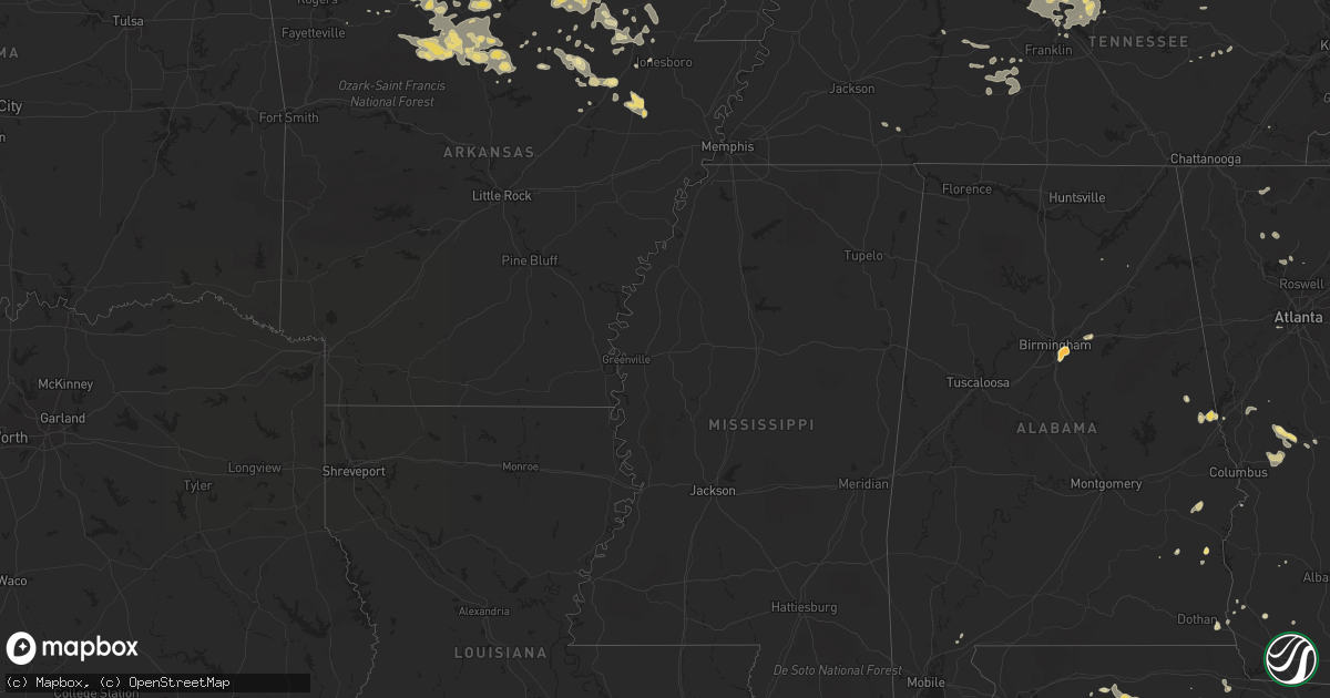
Hail Map in North Carolina on June 27, 2011
Get this storm
June 27 map
$229
one time, instant access
Download today. No call, no setup
Keep the $229
Bought the map and want the full workflow? Apply the entire $229 to a subscription within 7 days. None of it is wasted.
Every map, not just this one
This buys you this map. Subscription and you get every map we run, in the markets you choose from a few cities to whole states to nationwide. Plus real-time alerts the moment a storm fires.
Contact data
Name, contact info, occupancy, even credit band for addresses in the footprint. You go from where it hit to who to call.
Become the source they trust
Unlimited branding weather history reports on demand. You already have the documented answer ready for the property owner, and you are the one who showed up with it.
Property data and RoofTrace estimates
Pull up any address you have got, its value and the exact code rules for that jurisdiction, straight from One Click Code. Then RoofTrace estimates the squares, pitch, and roof value, priced the way you price.
Storm reports in North Carolina
North Carolina
| Date | Description |
|---|---|
| 06/27/20114:07 PM CDT | Multiple trees down along harry arys road |
| 06/27/20113:50 PM CDT | Numerous trees down just off of lewiston road |
| 06/27/20113:50 PM CDT | Golfball size hail along rte 158 in the great dismal swamp |
| 06/27/20113:45 PM CDT | Multiple trees down along us-117 and in calypso |
| 06/27/20113:44 PM CDT | Trees down near county home rd and nc hwy 102 |
| 06/27/20113:35 PM CDT | A local report indicates 60 MPH wind near OAK CITY |
| 06/27/20113:28 PM CDT | Large branches down. |
| 06/27/20113:27 PM CDT | Tree down on nc 125 near scotland neck. |
| 06/27/20113:15 PM CDT | Numerous trees down on indian woods road...just west of windsor |
| 06/27/20113:01 PM CDT | Multiple trees and powerlines down near kingsboro road and us 64 alt |
| 06/27/20112:50 PM CDT | Golfball size hail along rte 158 in the great dismal swamp |
| 06/27/20112:43 PM CDT | Tree down on a house on benton pond road in freemont... People still in the house |
| 06/27/20112:36 PM CDT | Tree down on west castalia road. |
| 06/27/20112:31 PM CDT | Tree down on house |
| 06/27/20112:18 PM CDT | One tree across road near intersection of boykin bridge road and peterson road |
| 06/27/20112:16 PM CDT | Tree down on webbs mill road. |
| 06/27/20112:16 PM CDT | Tree down on seven paths road. |
| 06/27/20112:01 PM CDT | Tree down near bailey |
| 06/27/20112:01 PM CDT | Tree down on powerline |
| 06/27/20112:01 PM CDT | Tree down on powerlines on old nash road |
| 06/27/20112:00 PM CDT | Three trees down near the intersection of nc-181 and frank whisnant road in the oak hill community. |
| 06/27/20111:55 PM CDT | Lee co 911 reported tree down at 2551 buckhorn rd. |
| 06/27/20111:51 PM CDT | Powerline down on hanes avenue |
| 06/27/20111:50 PM CDT | Tree down on squirrel den road |
| 06/27/20111:40 PM CDT | One tree down near the intersection of wendell road and salem church road |
| 06/27/20111:35 PM CDT | A local report indicates 1.00 inch wind near 6 NNW LAKE WACCAMAW |
| 06/27/20111:35 PM CDT | Wind gust to 48 mph during thunderstorm at the nws office on ncsu centennial campus. Numerous limbs down. |
| 06/27/20111:30 PM CDT | Tree down blocking hwy 55 in stonewall |
| 06/27/20111:27 PM CDT | Nws employee reported quarter size hail |
| 06/27/20111:20 PM CDT | Tree down near buffaloe lanes on highway 401. |
| 06/27/20111:18 PM CDT | One tree down on lake wheeler road |
| 06/27/20111:18 PM CDT | Several trees down near mid pines road... Time estimated by radar |
| 06/27/20111:17 PM CDT | Multiple trees down in downtown new bern near main and chatman rd |
| 06/27/20111:16 PM CDT | Several limbs up to 10 inch diameter and small trees down near manor ridge dr |
| 06/27/20111:11 PM CDT | Wect reports multiple trees down about three quarters of a mile from the intersection of highway 210 and 53 near kelly. Some trees were uprooted and some were snapped. |
| 06/27/20111:09 PM CDT | Skywarn spotter observed estimated wind gust 62 mph and penny size hail. |
| 06/27/20111:05 PM CDT | Tree down on trent rd. Time estimated by radar. |
| 06/27/201112:50 PM CDT | Tree down |
| 06/27/20114:57 AM CDT | 5 trees down at a residence on powell farm rd near anderson creek. |
| 06/26/20119:52 PM CDT | Tree down along corbett ridge road |
| 06/26/20119:27 PM CDT | Two trees down along burton chapel road |
| 06/26/20119:10 PM CDT | Tree down along hatchett road |
| 06/26/20119:10 PM CDT | Tree down along oak level church road |
| 06/26/20118:31 PM CDT | Several trees down across city of danbury |
| 06/26/20118:31 PM CDT | Several trees down |
| 06/26/20118:31 PM CDT | Tree down on house |
| 06/26/20118:10 PM CDT | Tree down along friendly road |
| 06/26/20118:00 PM CDT | Trees down at the intersection of reynolds st/harris st |
| 06/26/20117:57 PM CDT | Roof off of a house on 1033 klyce street. |
| 06/26/20117:54 PM CDT | Tree down on business 40 near winston-salem. |
| 06/26/20117:54 PM CDT | Tree down on us 52 near winston-salem. |
| 06/26/20117:35 PM CDT | Trees down in the city of king |
| 06/26/20117:34 PM CDT | Tree down on foxpark drive |
All States Impacted by Hail Map on June 27, 2011
Cities Impacted by Hail Map on June 27, 2011
- Watonga, OK
- Glencoe, AR
- Ash Flat, AR
- Grovespring, MO
- Windsor, NC
- Ahoskie, NC
- Colerain, NC
- Plum Branch, SC
- Edgefield, SC
- Modoc, SC
- Eddyville, KY
- Guthrie, KY
- Woodland, GA
- Elbert, CO
- Richlands, NC
- Ava, MO
- New Bern, NC
- Clarksville, FL
- Ewen, MI
- Lebanon, TN
- Gallatin, TN
- Mount Juliet, TN
- Trinidad, CO
- Capitan, NM
- Corona, NM
- Greenville, FL
- Monticello, FL
- Newark, AR
- Brixey, MO
- Gainesville, MO
- Hartville, MO
- Niangua, MO
- Yellville, AR
- Flippin, AR
- Taneyville, MO
- Garrison, MO
- Bradleyville, MO
- Oldfield, MO
- Ashford, AL
- Pansey, AL
- Clovis, NM
- Ernul, NC
- Cove City, NC
- Beulaville, NC
- Hobbsville, NC
- Sunbury, NC
- Corapeake, NC
- South Mills, NC
- Elizabeth City, NC
- Murray, KY
- Dexter, KY
- Anderson, SC
- South Greenfield, MO
- Cohasset, MN
- Remer, MN
- Ivanhoe, NC
- Harrells, NC
- Castalia, NC
- Ellington, MO
- Garland, NC
- Jasper, FL
- Lee, FL
- Cassville, MO
- Weir, KS
- Pittsburg, KS
- Swatara, MN
- Shirley, AR
- Fox, AR
- Mountain View, AR
- Lafayette, AL
- Roanoke, AL
- West Plains, MO
- Pomona, MO
- Lagrange, GA
- Lanett, AL
- Isabella, OK
- Fairview, OK
- Hickory Ridge, AR
- Fisher, AR
- Cherry Valley, AR
- Weiner, AR
- Farwell, TX
- Purdy, MO
- Monett, MO
- Verona, MO
- Sidney, AR
- Evening Shade, AR
- Horseshoe Bend, AR
- Madison, TN
- Whites Creek, TN
- Goodlettsville, TN
- Joelton, TN
- Hendersonville, TN
- Hardy, AR
- Callahan, FL
- Hilliard, FL
- Fuquay Varina, NC
- Apex, NC
- Raleigh, NC
- Chadwick, MO
- Carrizozo, NM
- Wadley, AL
- Harrison, AR
- Clayton, NC
- Garner, NC
- Wendell, NC
- Knightdale, NC
- Okarche, OK
- Calumet, OK
- Geary, OK
- Fancy Gap, VA
- Galax, VA
- Brentwood, TN
- Nashville, TN
- Warsaw, NC
- East Bend, NC
- Lewisville, NC
- Pfafftown, NC
- Park Falls, WI
- Scotland Neck, NC
- Marenisco, MI
- Kinston, NC
- Deep Run, NC
- Fowler, CO
- Model, CO
- Sedalia, CO
- Guion, AR
- Raton, NM
- Springer, NM
- Mountain Grove, MO
- Mammoth Spring, AR
- Cherokee Village, AR
- Whiteville, NC
- Hallsboro, NC
- Faison, NC
- Clinton, NC
- Turkey, NC
- Box Springs, GA
- Talbotton, GA
- Laverne, OK
- Friona, TX
- Plato, MO
- Huggins, MO
- Wake Forest, NC
- Zebulon, NC
- Lead Hill, AR
- Peel, AR
- Moriarty, NM
- Aurora, NC
- Elida, NM
- Floyd, NM
- Portales, NM
- Cedar Mountain, NC
- Pleasant Hope, MO
- Fair Grove, MO
- Encino, NM
- Seiling, OK
- Tuckerman, AR
- Newport, AR
- Lincolnton, GA
- Iva, SC
- Calhoun Falls, SC
- Lowndesville, SC
- Abbeville, SC
- Thayer, MO
- Willow Spring, NC
- Holly Springs, NC
- Cary, NC
- Marianna, FL
- Council, NC
- Clarkton, NC
- Lake Waccamaw, NC
- Rural Hall, NC
- Pinnacle, NC
- King, NC
- Tobaccoville, NC
- Hopkinsville, KY
- Oklahoma City, OK
- Tecumseh, MO
- Mooreland, OK
- Chester, OK
- Tallahassee, FL
- Outing, MN
- Pequot Lakes, MN
- Fifty Lakes, MN
- Pine River, MN
- Emily, MN
- Crosslake, MN
- Crosby, MN
- Balko, OK
- Beaver, OK
- Panama City, FL
- Youngstown, FL
- Shattuck, OK
- Pink Hill, NC
- Kenansville, NC
- Hereford, TX
- Westminster, SC
- Lincoln, NM
- Zanoni, MO
- Rueter, MO
- Noble, MO
- Mountain Home, AR
- Squires, MO
- Thornfield, MO
- Cotter, AR
- Clarkridge, AR
- Wasola, MO
- Gassville, AR
- Lakeview, AR
- Bull Shoals, AR
- Midway, AR
- Isabella, MO
- Pontiac, MO
- Dora, MO
- Theodosia, MO
- Hardenville, MO
- Whitakers, NC
- Enfield, NC
- Union Mills, NC
- Lake Lure, NC
- Merritt, NC
- Oriental, NC
- Grantsboro, NC
- Bayboro, NC
- Pampa, TX
- Harriet, AR
- Big Flat, AR
- Batesville, AR
- Marcella, AR
- Larkspur, CO
- Fort Supply, OK
- Woodward, OK
- Tyner, NC
- White House, TN
- Cottontown, TN
- Ash Grove, MO
- Walnut Grove, MO
- Shell Knob, MO
- Trenton, NC
- Mount Airy, NC
- Perry, FL
- Marshall, AR
- Hillsville, VA
- Ararat, VA
- Roswell, NM
- Birmingham, AL
- Pembroke, KY
- Oak Grove, KY
- Herndon, KY
- Wooton, KY
- Evergreen, NC
- Bladenboro, NC
- Cadiz, KY
- Gracey, KY
- Wilson, NC
- Elm City, NC
- Lockwood, MO
- Golden City, MO
- Lamar, MO
- Defuniak Springs, FL
- Nashville, NC
- Spring Hope, NC
- Greenville, NC
- Crab Orchard, KY
- Rocky Mount, NC
- Pinetops, NC
- Cave City, AR
- Bardwell, KY
- Eufaula, AL
- Waverly, TN
- New Johnsonville, TN
- Aurora, MO
- Seymour, MO
- Mansfield, MO
- Tarboro, NC
- Macclesfield, NC
- Springfield, MO
- Oakland, KY
- Bowling Green, KY
- Portland, TN
- Bradford, AR
- Old Town, FL
- Cross City, FL
- Lake Mary, FL
- Welch, OK
- Kingfisher, OK
- Mims, FL
- Oviedo, FL
- Drury, MO
- Palmersville, TN
- Black Rock, AR
- Ravenden, AR
- Imboden, AR
- Melbourne, AR
- Oronogo, MO
- Liberal, MO
- Clarkson, KY
- Leitchfield, KY
- Morgantown, KY
- Pottersville, MO
- Willow Springs, MO
- Cerulean, KY
- Hazel, KY
- New Concord, KY
- Almo, KY
- Buchanan, TN
- Poughkeepsie, AR
- Oswego, KS
- Muleshoe, TX
- Granby, MO
- Pierce City, MO
- Stark City, MO
- Blue Eye, MO
- Oak Grove, AR
- Wentworth, MO
- Lampe, MO
- Berryville, AR
- Diamond, MO
- Onia, AR
- Timbo, AR
- Robersonville, NC
- Bethel, NC
- May, OK
- Fargo, OK
- Buffalo, OK
- Palisade, MN
- Hill City, MN
- Altha, FL
- Cashion, OK
- Ninety Six, SC
- Saluda, SC
- Mutual, OK
- Crane, MO
- Marshfield, MO
- Grand Ridge, FL
- Des Moines, NM
- Williamsport, TN
- Mount Pleasant, TN
- Columbia, TN
- Hampshire, TN
- Nazareth, TX
- Tulia, TX
- Dimmitt, TX
- Colquitt, GA
- Grand Rapids, MN
- Hindsville, AR
- Huntsville, AR
- Hobucken, NC
- Lowland, NC
- Vanzant, MO
- Seneca, SC
- Townville, SC
- Fountain, FL
- Ware Shoals, SC
- Laurens, SC
- Waterloo, SC
- Washington, NC
- Kelly, NC
- Saint Joe, AR
- Gilbert, AR
- Texico, NM
- Broadview, NM
- Leslie, AR
- Crossville, TN
- Omaha, AR
- Pelham, AL
- Kirksey, KY
- Canyon, TX
- Canton, GA
- Western Grove, AR
- Vendor, AR
- Mount Judea, AR
- Elizabeth, CO
- Kiowa, CO
- Freeport, FL
- Castle Rock, CO
- Franktown, CO
- Gatesville, NC
- La Junta, CO
- Horse Branch, KY
- Cromwell, KY
- Mclean, TX
- Carmen, OK
- Sulphur Rock, AR
- Eureka Springs, AR
- Salem, AR
- Sturkie, AR
- Hurtsboro, AL
- Elberton, GA
- Bovina, TX
- Smiths Grove, KY
- Camilla, GA
- Battleboro, NC
- Thomas, OK
- Jasper, MO
- Adamsville, TN
- Morris Chapel, TN
- Chatsworth, GA
- Louisville, AL
- Springfield, TN
- Ponce De Leon, FL
- Bethpage, TN
- Pleasant View, TN
- Castalian Springs, TN
- Hermitage, TN
- Antioch, TN
- Ashland City, TN
- Greenbrier, TN
- Cross Plains, TN
- Chapmansboro, TN
- Old Hickory, TN
- Deland, FL
- Sparta, MO
- Yanceyville, NC
- Sparta, TN
- Travelers Rest, SC
- Hagerman, NM
- Saluda, NC
- Vero Beach, FL
- Edenton, NC
- Couch, MO
- Myrtle, MO
- Cash, AR
- Eminence, MO
- Charlotte, AR
- Locust Grove, AR
- Pleasant Grove, AR
- West Point, GA
- Brevard, NC
- Olmstead, KY
- Russellville, KY
- Ocate, NM
- Carl Junction, MO
- Greenville, GA
- Saint Charles, KY
- Dawson Springs, KY
- Primm Springs, TN
- Lyles, TN
- Santa Fe, TN
- Barbourville, KY
- Gray, KY
- Girdler, KY
- Hollister, MO
- Baxter, KY
- Bledsoe, KY
- Joplin, MO
- Carthage, MO
- Carterville, MO
- Mershon, GA
- Manchester, GA
- Shiloh, GA
- Fairmount, GA
- Franklin, KY
- Scottsville, KY
- Las Vegas, NM
- Newton, GA
- Vega, TX
- Wildorado, TX
- Willard, MO
- Brighton, MO
- Edmond, OK
- Aline, OK
- Norwood, MO
- Snow Hill, NC
- Walstonburg, NC
- Stantonsburg, NC
- Rich Square, NC
- Jackson, NC
- Edna, KS
- Bartlett, KS
- Altamont, KS
- Fargo, GA
- Altamonte Springs, FL
- Longwood, FL
- Pine Mountain, GA
- Keokee, VA
- Apopka, FL
- Hoxie, AR
- Lynn, AR
- Alicia, AR
- Powhatan, AR
- Saint George, GA
- Kingsland, GA
- Folkston, GA
- Hardin, KY
- Benton, KY
- Deer River, MN
- Clarendon, TX
- Elizabethtown, NC
- Rose Hill, NC
- Hasty, AR
- Tompkinsville, KY
- Mount Hermon, KY
- Moody, AL
- Odenville, AL
- Pell City, AL
- Leeds, AL
- Phillips, WI
- Clayton, AL
- Clarksville, TN
- Adairville, KY
- Trenton, KY
- Allensville, KY
- Elkton, KY
- Lewisburg, KY
- Morganton, NC
- Camp, AR
- Ravenden Springs, AR
- Pocahontas, AR
- Beaver Dam, KY
- Rochester, KY
- Niceville, FL
- Eglin Afb, FL
- Kenly, NC
- Canton, OK
- Vanceboro, NC
- Hyden, KY
- Stinnett, KY
- Mount Pleasant, AR
- Minocqua, WI
- Charleston, MO
- Happy, TX
- Tignall, GA
- Cofield, NC
- Harrellsville, NC
- London, KY
- Panhandle, TX
- White Deer, TX
- Hartwell, GA
- Farmville, NC
- McGrady, NC
- White Oak, GA
- Chesapeake, VA
- Waynesburg, KY
- Marion, NC
- Rutherfordton, NC
- Old Fort, NC
- Jacksonville, NC
- Galena, MO
- Reeds Spring, MO
- Everton, AR
- Midway, GA
- Longville, MN
- Chiefland, FL
- Princeton, KY
- Central City, KY
- Centertown, KY
- Rockport, KY
- Shellman, GA
- Albertson, NC
- Seven Springs, NC
- Salem, MO
- Hydro, OK
- Hinton, OK
- Loyal, OK
- Guthrie, OK
- Perryville, MO
- Lac Du Flambeau, WI
- Mount Olive, NC
- New Tazewell, TN
- Waleska, GA
- Oil Trough, AR
- Rosie, AR
- Magness, AR
- Centerville, TN
- Steelville, MO
- Camden, NC
- Shawboro, NC
- Lewiston Woodville, NC
- Watrous, NM
- Calhan, CO
- Manchester, KY
- Oneida, KY
- Sharon Springs, KS
- Green Forest, AR
- Ridgedale, MO
- Koshkonong, MO
- Branson, MO
- Pengilly, MN
- Pyatt, AR
- Walnut Ridge, AR
- Madison, FL
- Dawson, GA
- Longdale, OK
- Quitman, GA
- Fountain Run, KY
- Holland, KY
- Austin, KY
- Greenwood, SC
- Cabool, MO
- Pindall, AR
- Cherokee, KS
- Scammon, KS
- Auburn, KY
- Mountville, SC
- Hodges, SC
- Putney, KY
- Willard, NC
- Alpharetta, GA
- Dahlonega, GA
- Bay Minette, AL
- Connelly Springs, NC
- Claude, TX
- Newton, NC
- Hickory, NC
- Vale, NC
- Jasper, AR
- Atlanta, GA
- Kress, TX
- Cana, VA
- Hartsfield, GA
- Moultrie, GA
- Roseboro, NC
- Bruce Crossing, MI
- Golden, MO
- Exeter, MO
- Alpena, AR
- Norfork, AR
- Kimberling City, MO
- Butterfield, MO
- Valley Springs, AR
- Clinton, AR
- Kirbyville, MO
- Lenoir, NC
- Fremont, NC
- Swifton, AR
- Brownsville, KY
- Backus, MN
- Franklin, TN
- Delaplaine, AR
- Middlesex, NC
- Martin, GA
- Toccoa, GA
- Cookeville, TN
- Rickman, TN
- Edgemont, AR
- Sims, NC
- Pikeville, NC
- Selma, NC
- Lucama, NC
- Alvaton, KY
- Suffolk, VA
- Adams, TN
- Cedar Hill, TN
- Hertford, NC
- Bethel Springs, TN
- Pisgah Forest, NC
- Dexter, NM
- Calhoun, TN
- Riceville, TN
- Dover, TN
- Blakely, GA
- Bon Aqua, TN
- Nunnelly, TN
- Dickson, TN
- McEwen, TN
- Hohenwald, TN
- Belvidere, NC
- Mill Spring, NC
- Columbus, NC
- Jakin, GA
- Frohna, MO
- Success, AR
- Hazard, KY
- Hobgood, NC
- Tinnie, NM
- Omaha, GA
- Lamont, FL
- Boaz, AL
- Damascus, GA
- Essie, KY
- Sizerock, KY
- Webb City, MO
- New Hill, NC
- Caneyville, KY
- Albertville, AL
- Jennings, FL
- Dunmor, KY
- Belton, KY
- Columbus, KS
- Chipley, FL
- Butler, GA
- Walnut Cove, NC
- Carlisle, KY
- La Grange, NC
- Goldsboro, NC
- Clarks Hill, SC
- Williford, AR
- Henderson, AR
- Atkinson, NC
- Lake Tomahawk, WI
- Weatherford, OK
- Ironwood, MI
- Fruitland Park, FL
- Metropolis, IL
- Sanderson, FL
- Glen Saint Mary, FL
- Landrum, SC
- Zirconia, NC
- Eastanollee, GA
- Casar, NC
- Ellenboro, NC
- White Oak, NC
- Drakesboro, KY
- Asbury, MO
- Bunn, NC
- Anton Chico, NM
- Oakwood, OK
- Williamston, NC
- Ozark, MO
- Rogersville, MO
- Crofton, KY
- Southard, OK
- Vici, OK
- Birch Tree, MO
- Summersville, MO
- Jonesboro, AR
- Beech Grove, AR
- Peach Orchard, AR
- Biggers, AR
- Stockton, AL
- Winter, WI
- Dover, NC
- Duck River, TN
- Van Buren, MO
- Roundhill, KY
- Abbeville, AL
- Hurricane Mills, TN
- Angora, MN
- Lyons, GA
- Mount Dora, FL
- Portia, AR
- Smithville, AR
- Rockfield, KY
- Sextons Creek, KY
- Tyner, KY
- Pavo, GA
- Dixie, GA
- Roxobel, NC
- Millwood, KY
- Bono, AR
- Magnolia, NC
- Brundidge, AL
- Sanford, NC
- Ribera, NM
- La Loma, NM


