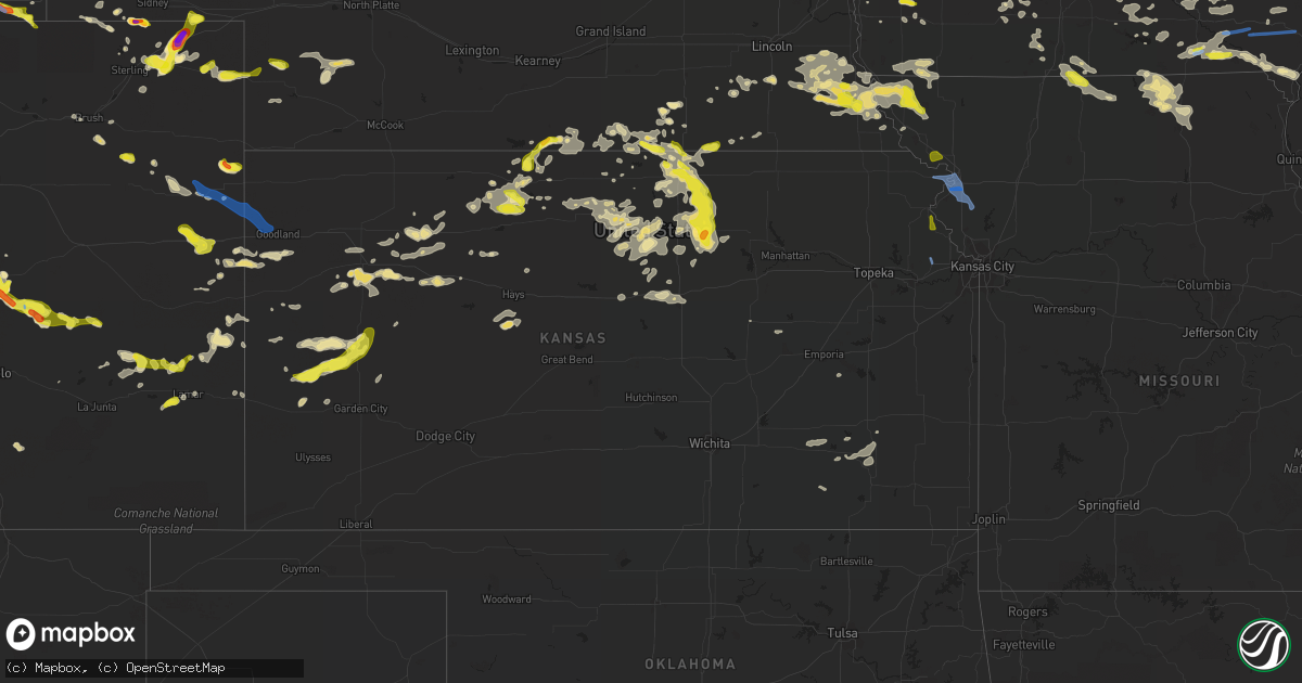
Hail Map in Kansas on June 26, 2020
Get this storm
June 26 map
$229
one time, instant access
Download today. No call, no setup
Keep the $229
Bought the map and want the full workflow? Apply the entire $229 to a subscription within 7 days. None of it is wasted.
Every map, not just this one
This buys you this map. Subscription and you get every map we run, in the markets you choose from a few cities to whole states to nationwide. Plus real-time alerts the moment a storm fires.
Contact data
Name, contact info, occupancy, even credit band for addresses in the footprint. You go from where it hit to who to call.
Become the source they trust
Unlimited branding weather history reports on demand. You already have the documented answer ready for the property owner, and you are the one who showed up with it.
Property data and RoofTrace estimates
Pull up any address you have got, its value and the exact code rules for that jurisdiction, straight from One Click Code. Then RoofTrace estimates the squares, pitch, and roof value, priced the way you price.
Storm reports in Kansas
Kansas
| Date | Description |
|---|---|
| 06/26/20206:57 AM CDT | At 1156 PM CDT, a severe thunderstorm was located 8 miles south of Glade, or 13 miles south of Phillipsburg, moving east at 15 mph. This replaces the previous warning for southern Phillips and northern Rooks counties. HAZARD...Ping pong ball size hail and 60 mph wind gusts. SOURCE...Radar indicated. IMPACT...People and animals outdoors will be injured. Expect hail damage to roofs, siding, windows, and vehicles. Expect wind damage to roofs, siding, and trees. Locations impacted include... Stockton, Kirwin, Woodston and Alton. |
| 06/26/20206:38 AM CDT | At 1137 PM CDT, severe thunderstorms were located along a line extending from 5 miles south of Clay Center to 3 miles northwest of Oak Hill to 7 miles southwest of Miltonvale, moving south at 15 mph. HAZARD...60 mph wind gusts and half dollar size hail. SOURCE...Radar indicated. IMPACT...Hail damage to vehicles is expected. Expect wind damage to roofs, siding, and trees. Locations impacted include... Clay Center, Miltonvale, Wells, Manchester, Longford, Oak Hill and Idana. |
| 06/26/20206:14 AM CDT | At 1113 PM CDT, a severe thunderstorm was located near Kirwin, or 11 miles southeast of Phillipsburg, moving east at 10 mph. HAZARD...60 mph wind gusts and half dollar size hail. SOURCE...Radar indicated. IMPACT...Hail damage to vehicles is expected. Expect wind damage to roofs, siding, and trees. Locations impacted include... Phillipsburg, Logan, Kensington, Agra, Kirwin, Alton, Glade and Speed. |
| 06/26/20206:03 AM CDT | At 1103 PM CDT, a severe thunderstorm was located 5 miles northeast of Miltonvale, moving south-southeast at 20 mph. HAZARD...Ping pong ball size hail and 60 mph wind gusts. SOURCE...Radar indicated. IMPACT...People and animals outdoors will be injured. Expect hail damage to roofs, siding, windows, and vehicles. Expect wind damage to roofs, siding, and trees. Locations impacted include... Clay Center, Miltonvale, Morganville, Aurora, Oak Hill and Idana. |
| 06/26/20205:30 AM CDT | At 1030 PM CDT, a severe thunderstorm was located over Glade, or near Phillipsburg, moving northeast at 15 mph. HAZARD...60 mph wind gusts and quarter size hail. SOURCE...Radar indicated. IMPACT...Hail damage to vehicles is expected. Expect wind damage to roofs, siding, and trees. Locations impacted include... Phillipsburg, Logan, Kensington, Agra, Kirwin, Glade, Speed and Cedar. |
| 06/26/20205:27 AM CDT | At 1026 PM CDT, a severe thunderstorm was located over Vining, moving southeast at 25 mph. HAZARD...60 mph wind gusts and quarter size hail. SOURCE...Radar indicated. IMPACT...Hail damage to vehicles is expected. Expect wind damage to roofs, siding, and trees. Locations impacted include... Clay Center, Clyde, Clifton, Morganville, Palmer, Vining and Idana. |
| 06/26/20204:49 AM CDT | At 948 PM CDT, a severe thunderstorm was located near Agenda, moving southeast at 25 mph. HAZARD...Golf ball size hail and 60 mph wind gusts. SOURCE...Radar indicated. IMPACT...People and animals outdoors will be injured. Expect hail damage to roofs, siding, windows, and vehicles. Expect wind damage to roofs, siding, and trees. Locations impacted include... Clyde, Clifton, Linn, Cuba, Palmer, Agenda and Vining. |
| 06/26/20204:21 AM CDT | At 921 PM CDT, a severe thunderstorm was located near Belleville, moving southeast at 15 mph. HAZARD...Ping pong ball size hail and 60 mph wind gusts. SOURCE...Radar indicated. IMPACT...People and animals outdoors will be injured. Expect hail damage to roofs, siding, windows, and vehicles. Expect wind damage to roofs, siding, and trees. Locations impacted include... Belleville and Cuba. |
| 06/26/20204:12 AM CDT | Awos station khys hays regional airport awos site. |
| 06/26/20203:57 AM CDT | This report was from the kansas mesonet station hays |
| 06/26/20203:42 AM CDT | At 841 PM CDT, severe thunderstorms were located along a line extending from 6 miles northeast of Mahaska to 3 miles north of Haddam to 4 miles southeast of Scandia, moving east-southeast at 15 mph. HAZARD...60 mph wind gusts and half dollar size hail. SOURCE...Radar indicated. IMPACT...Hail damage to vehicles is expected. Expect wind damage to roofs, siding, and trees. Locations impacted include... Belleville, Scandia, Cuba, Morrowville, Haddam, Munden, Narka and Mahaska. |
| 06/26/20203:22 AM CDT | At 822 PM CDT, a severe thunderstorm was located 4 miles west of Munden, moving southeast at 10 mph. HAZARD...60 mph wind gusts and quarter size hail. SOURCE...Radar indicated. IMPACT...Hail damage to vehicles is expected. Expect wind damage to roofs, siding, and trees. Locations impacted include... Cuba, Munden and Narka. |
| 06/26/20203:10 AM CDT | Large tree branch |
| 06/26/20203:05 AM CDT | ***delayed report***several 6-9 inch tree branches torn off. |
| 06/26/20203:02 AM CDT | Nws employee reports patio table flipped. |
| 06/26/20203:00 AM CDT | Approx 18in. Diameter tree snapped at base. Fence knocked down. Other portions of fence blown over by wind. Tree width estimated from photo. |
| 06/26/20202:44 AM CDT | Play set knocked over. Time estimated from radar. |
| 06/26/20202:32 AM CDT | Em reports 61 mph gust measured in tonganoxie and power out in town. |
| 06/26/20202:30 AM CDT | A local report indicates 60 MPH wind near 11 S RUSSELL |
| 06/26/20202:25 AM CDT | At 725 PM MDT/825 PM CDT/, a severe thunderstorm was located 14 miles south of Wray, moving southeast at 10 mph. HAZARD...60 mph wind gusts and quarter size hail. SOURCE...Radar indicated. IMPACT...Hail damage to vehicles is expected. Expect wind damage to roofs, siding, and trees. Locations impacted include... Hale, Vernon and Beecher Island. This includes Highway 385 between mile markers 219 and 237. |
| 06/26/20202:16 AM CDT | Pws station kksnatom2. |
| 06/26/20202:15 AM CDT | Davis weatherlink station. |
| 06/26/20202:14 AM CDT | Pws station kksnatom2. |
| 06/26/20202:06 AM CDT | Davis weatherlink station. |
| 06/26/20202:03 AM CDT | A local report indicates 61 MPH wind near STOCKTON AIRPORT |
| 06/26/20201:54 AM CDT | Delayed report. |
| 06/26/20201:40 AM CDT | Mesonet station up852 3.7 w ogallah |
| 06/26/20201:36 AM CDT | Social media reports of power poles down due to strong thunderstorm winds. Time estimated based on reported winds at hlc. |
| 06/26/20201:36 AM CDT | Khlc asos reported wind gust of 64 mph. |
| 06/26/20201:20 AM CDT | Report was from social media. |
| 06/26/20201:05 AM CDT | Public reports large tree down across road in town. |
| 06/26/202012:50 AM CDT | Asos station kgck garden city. |
| 06/26/202012:49 AM CDT | Report was from the kansas mesonet station lnuk1. |
| 06/26/202012:45 AM CDT | Mesonet station as692 scott city. |
| 06/26/202012:44 AM CDT | Corrected from previous report. Coop observer reported several branches and tree limbs down around town... Some as large as 8 inches in diameter. |
| 06/26/202012:37 AM CDT | A local report indicates 62 MPH wind near 10 SE SCOTT CITY |
| 06/26/202012:35 AM CDT | Photos of a light pole down... Sign damage... And roof damage in scott city. |
| 06/25/202011:50 PM CDT | A local report indicates 1.75 inch wind near MILTONVALE |
| 06/25/202011:26 PM CDT | A local report indicates 1.25 inch wind near 1 SE AURORA |
| 06/25/202011:25 PM CDT | Near 18th and buffalo road. |
| 06/25/202011:13 PM CDT | A local report indicates 1.00 inch wind near 5 WSW AGRA |
| 06/25/202010:45 PM CDT | Delayed report. Estimated 12 inch branches down. Additional large tree limb damage near 18th and archer. |
| 06/25/202010:40 PM CDT | Mesonet station k5wlc us-40 - 2 mi. W of wallace. |
| 06/25/202010:33 PM CDT | Corrects previous tstm wnd gst report from 3 wsw clyde. Wind gust blew police vehicle off the road. |
| 06/25/202010:20 PM CDT | 3 to 4 inch diameter limbs down. |
| 06/25/202010:15 PM CDT | Tree down on s. Grant street... Multiple limbs down around town. |
| 06/25/202010:06 PM CDT | A local report indicates 59 MPH wind near 1 NE GOODLAND |
| 06/25/20209:32 PM CDT | A local report indicates 1.00 inch wind near BELLEVILLE |
| 06/25/20208:38 PM CDT | A local report indicates 1.00 inch wind near 4 N BELLEVILLE |
All States Impacted by Hail Map on June 26, 2020
Cities Impacted by Hail Map on June 26, 2020
- Olney Springs, CO
- Garden Prairie, IL
- Genoa, IL
- Marengo, IL
- Oshkosh, NE
- Lewellen, NE
- Belleville, KS
- Republic, KS
- Aurora, CO
- Cleveland, OH
- Maple Heights, OH
- Goodland, KS
- Akron, CO
- Presque Isle, ME
- Sedalia, CO
- Castle Rock, CO
- Whitman, NE
- Cody, NE
- Belvidere, IL
- Clifton, KS
- Morganville, KS
- Concordia, KS
- Cuba, KS
- Aurora, KS
- Scandia, KS
- Miltonvale, KS
- Clay Center, KS
- Clyde, KS
- Munden, KS
- Agenda, KS
- Grover, CO
- Cheyenne, WY
- Carpenter, WY
- Fe Warren Afb, WY
- Glasco, KS
- Watseka, IL
- Palmer Lake, CO
- Franktown, CO
- Peyton, CO
- Usaf Academy, CO
- Monument, CO
- Colorado Springs, CO
- Elbert, CO
- Larkspur, CO
- Sidney, NE
- Deshler, NE
- Kanorado, KS
- Burlington, CO
- Weskan, KS
- Fleming, CO
- Phillipsburg, KS
- Burlington, IL
- Sycamore, IL
- Elgin, IL
- Maple Park, IL
- Hampshire, IL
- Saint Charles, IL
- Sugar City, CO
- Arlington, CO
- Arthur, NE
- Lemoyne, NE
- Sheridan Lake, CO
- Haswell, CO
- Padroni, CO
- Plainville, KS
- Palco, KS
- Scott City, KS
- Leoti, KS
- Lakin, KS
- Deerfield, KS
- Marienthal, KS
- Pueblo, CO
- Golden, CO
- Rush, CO
- Yoder, CO
- Crook, CO
- Grady, NM
- Ashby, NE
- Imperial, NE
- Jewell, KS
- Fort Collins, CO
- Laporte, CO
- Bellvue, CO
- Narka, KS
- Sedgwick, CO
- Haxtun, CO
- Grinnell, KS
- Oakley, KS
- Davenport, NE
- Karval, CO
- La Rue, OH
- Guide Rock, NE
- Donnellson, IA
- Calhan, CO
- Holyoke, CO
- Paoli, CO
- Brookville, KS
- Salina, KS
- Hertford, NC
- Belvidere, NC
- Wakeeney, KS
- Collyer, KS
- Quinter, KS
- Sterling, NE
- Hasty, CO
- Richland, IA
- Grand Ridge, IL
- Marseilles, IL
- Eads, CO
- Knoxville, IA
- Hamilton, IA
- Bussey, IA
- Logan, KS
- Zwingle, IA
- Bernard, IA
- Cook, NE
- Piedmont, KS
- Eureka, KS
- Severy, KS
- Dunkirk, OH
- Kenton, OH
- New Bloomington, OH
- Forest, OH
- Rochelle, IL
- Chana, IL
- Franklin Grove, IL
- Ashton, IL
- Dixon, IL
- Polo, IL
- Oregon, IL
- Nemaha, NE
- Auburn, NE
- Brownville, NE
- Peru, NE
- Model, CO
- Grainfield, KS
- Lorimor, IA
- Afton, IA
- Wallace, NE
- Hayes Center, NE
- Loveland, CO
- Bloomington, NE
- Franklin, NE
- Riverton, NE
- Bedford, OH
- Independence, OH
- Lakewood, OH
- Rocky River, OH
- Craig, MO
- Superior, NE
- Hardy, NE
- Peetz, CO
- Seneca, IL
- Verona, IL
- Bethune, CO
- Vona, CO
- Stratton, CO
- Beloit, KS
- La Crosse, KS
- Idalia, CO
- Wray, CO
- Cullom, IL
- Kempton, IL
- Ashkum, IL
- Piper City, IL
- Courtland, KS
- Webber, KS
- Ellsworth, KS
- Lincoln, KS
- Douds, IA
- Milton, IA
- Keosauqua, IA
- Bloomfield, IA
- Rushville, NE
- Hay Springs, NE
- Frazeysburg, OH
- Glen Elder, KS
- Edgar, NE
- Minneapolis, KS
- Wiley, CO
- Champion, NE
- Brush, CO
- Winona, KS
- Red Oak, IA
- Barnard, KS
- Littleton, CO
- Hyannis, NE
- Sheldon, IL
- Palmyra, NE
- Unadilla, NE
- Delphos, KS
- Milan, IL
- Sherrard, IL
- Altoona, KS
- Fredonia, KS
- Benedict, KS
- Sedan, NM
- Tarkio, MO
- Mapleton, ME
- Patten, ME
- Garden City, KS
- Clovis, NM
- Simpson, KS
- Cresco, IA
- Diller, NE
- Odell, NE
- Shannon, IL
- Lanark, IL
- Denver, CO
- Agra, KS
- Kensington, KS
- Inavale, NE
- Hoxie, KS
- Morland, KS
- Burr Oak, KS
- Mankato, KS
- Macedonia, IA
- Henderson, IA
- Emerson, IA
- Vernon, CO
- Harvey, IA
- Leighton, IA
- Pella, IA
- Syracuse, NE
- Chester, NE
- Byron, NE
- Chappell, NE
- Morris, IL
- Ellston, IA
- Grand River, IA
- Kellerton, IA
- Thayer, IA
- Wellington, CO
- Lamar, CO
- Elk Falls, KS
- Moline, KS
- Fremont, IA
- Kirkville, IA
- Eddyville, IA
- Ottumwa, IA
- Joes, CO
- Norway, KS
- Sharon Springs, KS
- Lawrence, NE
- Melcher Dallas, IA
- Hallam, NE
- Firth, NE
- Martell, NE
- Cortland, NE
- Hill City, KS
- Melrose, IA
- Moravia, IA
- Kirksville, MO
- Greentop, MO
- Clayton, NM
- Esbon, KS
- Downs, KS
- Glenwood, MO
- Worthington, MO
- Unionville, MO
- Livonia, MO
- Green Castle, MO
- Novinger, MO
- Queen City, MO
- Wheatland, WY
- Pine Bluffs, WY
- Fredericksburg, IA
- Lawler, IA
- Byron, IL
- Wilber, NE
- Glade, KS
- Kirwin, KS
- Stockton, KS
- Sarasota, FL
- Mount Carroll, IL
- Sylvan Grove, KS
- Portis, KS
- Jamestown, KS
- Hunter, KS
- Gaylord, KS
- Cawker City, KS
- Amboy, IL
- Rock Falls, IL
- Deer Grove, IL
- Tampico, IL
- Prophetstown, IL
- Harmon, IL
- Cheyenne Wells, CO
- Las Animas, CO
- Shickley, NE
- Carleton, NE
- Sheridan, IL
- Serena, IL
- Newark, IL
- Dix, NE
- Cascade, CO
- Henry, IL
- Beverly, KS
- Nebraska City, NE
- Dunbar, NE
- Glenwood, IA
- Liebenthal, KS
- Pleasantville, IA
- Milo, IA
- Tescott, KS
- South Elgin, IL
- Arapahoe, CO
- Bogue, KS
- Elsie, NE
- Wauneta, NE
- Dickens, NE
- Baileyville, IL
- Manitou Springs, CO
- Bonaparte, IA
- Braddyville, IA
- Hamburg, IA
- Burlington Junction, MO
- Clarinda, IA
- Farragut, IA
- Blanchard, IA
- Coin, IA
- Westboro, MO
- Elmo, MO
- Shenandoah, IA
- Northboro, IA
- Crete, NE
- Ruskin, NE
- Nelson, NE
- Lime Springs, IA
- Cincinnati, IA
- Monument, KS
- Farmington, IA
- Bagley, WI
- Bloomington, WI
- Glen Haven, WI
- Park, KS
- Gove, KS
- Bruning, NE
- Union, IL
- Hebron, NE
- Otoe, NE
- Avoca, NE
- Keota, IA
- Sigourney, IA
- Harper, IA
- Cedar, KS
- Stockbridge, MI
- Munith, MI
- Gregory, MI
- Grass Lake, MI
- Chelsea, MI
- Champaign, IL
- Urbana, IL
- Ansley, NE
- Malvern, IA
- Prairie View, KS
- Rock Port, MO
- Humboldt, NE
- Adams, NE
- Fairfax, MO
- Tecumseh, NE
- Talmage, NE
- Lorton, NE
- Johnson, NE
- Elk Creek, NE
- Maitland, MO
- Watson, MO
- Douglas, NE
- Shubert, NE
- Mound City, MO
- Julian, NE
- Bennet, NE
- Brock, NE
- Stella, NE
- Burr, NE
- Skidmore, MO
- Walnut, IL
- Ohio, IL
- Forreston, IL
- Clio, IA
- Lineville, IA
- Garden Grove, IA
- Allerton, IA
- Leon, IA
- Tribune, KS
- Ann Arbor, MI
- Kimball, NE
- Cainsville, MO
- Davis City, IA
- Mercer, MO
- Fairbury, NE
- Reynolds, NE
- Iron River, MI
- Watersmeet, MI
- Nederland, CO
- McIntosh, AL
- Selden, KS
- Crown Point, IN
- Hebron, IN
- Creston, IA
- Granite Canon, WY
- Livermore, CO
- Tie Siding, WY
- Pecatonica, IL
- Winnebago, IL
- Ogden, IL
- Armstrong, IL
- Saint Joseph, IL
- Fithian, IL
- Royal, IL
- Hubbell, NE
- Mahaska, KS
- Chester, IA
- Argyle, IA
- Fort Madison, IA
- Montrose, IA
- Lenora, KS
- Kirk, CO
- Sterling, IL
- Packwood, IA
- Hedrick, IA
- Ollie, IA
- Riceville, IA
- McCracken, KS
- Davis Junction, IL
- Monroe Center, IL
- Sterling, CO
- Valparaiso, IN
- Laramie, WY
- Yuma, CO
- Chariton, IA
- Beaverville, IL
- Longford, KS
- New Sharon, IA
- Illinois City, IL
- Batavia, IA
- Fairfield, IA
- Ordway, CO
- Mount Pleasant, IA
- Winfield, IA
- Wayland, IA
- Newtown, MO
- Lucerne, MO
- Ransom, IL
- Ottawa, IL
- Mazon, IL
- Kinsman, IL
- Tobias, NE
- Harrison, NE
- Crawford, NE
- Eldena, IL
- Oskaloosa, IA
- Herington, KS
- Dwight, IL
- Taylor Ridge, IL
- Fort Morgan, CO
- Deer Park, AL
- Chipley, FL
- Youngstown, FL
- Princeton, MO
- Potter, NE
- Springfield, ME
- Smith Center, KS
- Hays, KS
- Schoenchen, KS
- Catharine, KS
- Columbus Junction, IA
- Lone Tree, IA
- Ainsworth, IA
- Nichols, IA
- Riverside, IA
- Boulder, CO
- Broomfield, CO
- Eldorado Springs, CO
- Drakesville, IA
- Morrison, IL
- Newark, OH
- Nashport, OH
- Columbia, IA
- Waycross, GA
- Roberts, IL
- Mount Morris, IL
- Tracy, IA
- Merriman, NE
- Iliff, CO
- Mystic, IA
- Harvard, IL
- Buffalo, KS
- Holly, CO
- Fall River, KS
- New Boston, IL
- Joy, IL
- Reynolds, IL
- Dorchester, NE
- Hartley, TX
- Elliott, IA
- Griswold, IA
- Parker, CO
- Danforth, IL
- Gilman, IL
- Crescent City, IL
- Donovan, IL
- Red Cloud, NE
- Dexter, MI
- Randall, KS
- Albia, IA
- Unionville, IA
- Blakesburg, IA
- Waucoma, IA
- New Hampton, IA
- Leaf River, IL
- Brashear, MO
- Lancaster, MO
- Exline, IA
- Arvada, CO
- Hemingford, NE
- Peosta, IA
- Dubuque, IA
- La Motte, IA
- Wallace, KS
- Heath, OH
- Zanesville, OH
- Hopewell, OH
- Washington, IA
- Dighton, KS
- Healy, KS
- Lindenwood, IL
- Milledgeville, IL
- Woosung, IL
- Malta, IL
- Clare, IL
- Dekalb, IL
- Kirkland, IL
- Esmond, IL
- Putnam, IL
- Wellman, IA
- Kalona, IA
- Clifton, IL
- Lamoni, IA
- Lebanon, KS
- Council Grove, KS
- Wilsey, KS
- Red Feather Lakes, CO
- Pollock, MO
- Cherry Valley, IL
- Kingston, IL
- Russell, IA
- Lovilia, IA
- Sherrill, IA
- Colby, KS
- Harmony, MN
- Chatsworth, IL
- Streator, IL
- Wenona, IL
- Dana, IL
- Endicott, NE
- Eldon, IA
- Libertyville, IA
- Moulton, IA
- Floris, IA
- Selma, IA
- Pulaski, IA
- Nauvoo, IL
- Cantril, IA
- Mount Sterling, IA
- Channahon, IL
- La Moille, IL
- Sublette, IL
- Falls City, NE
- Hillsdale, WY
- Potosi, WI
- Martinsburg, IA
- Clermont, FL
- Grenville, NM
- Eastlake, OH
- Wickliffe, OH
- Willoughby, OH
- Euclid, OH
- Tryon, NE
- Alton, KS
- Stanton, IA
- Blackstone, IL
- Oak, NE
- Swanton, NE
- Western, NE
- Hartford, KS
- Moultrie, GA
- Wagarville, AL
- Martinton, IL
- Cope, CO
- Yates Center, KS
- Clatonia, NE
- Athol, KS
- McIntire, IA
- Naponee, NE
- Toronto, KS
- Chenoa, IL
- Mabel, MN
- Decorah, IA
- Canton, MN
- Ionia, IA
- Nashua, IA
- Birmingham, IA
- Stockport, IA
- Salem, IA
- New London, IA
- Lockridge, IA
- Atchison, KS
- Easton, KS
- Lawrence, MI
- Watervliet, MI
- Decatur, MI
- Hartford, MI
- Coloma, MI
- Benton Harbor, MI
- Saint Joseph, MI
- Buchanan, MI
- Niles, MI
- Granger, IN
- Lakeside, MI
- Three Oaks, MI
- Harbert, MI
- Galien, MI
- Sawyer, MI
- Bridgman, MI
- Stevensville, MI
- Berrien Springs, MI
- Baroda, MI
- Dalhart, TX
- German Valley, IL
- Rockford, IL
- Ridott, IL
- Rock City, IL
- Bristol, IL
- Aurora, IL
- Plano, IL
- Hinckley, IL
- Earlville, IL
- Steward, IL
- Lee, IL
- Shabbona, IL
- Somonauk, IL
- West Brooklyn, IL
- Sandwich, IL
- Montgomery, IL
- Compton, IL
- Big Rock, IL
- Paw Paw, IL
- Sugar Grove, IL
- Waterman, IL
- Bartlett, IL
- Itasca, IL
- Bensenville, IL
- Chicago, IL
- Addison, IL
- Franklin Park, IL
- Medinah, IL
- Bloomingdale, IL
- Schiller Park, IL
- Roselle, IL
- Wood Dale, IL
- Hanover Park, IL
- Culver, IN
- Hobart, IN
- Grovertown, IN
- Knox, IN
- Hamlet, IN
- Tinley Park, IL
- Mokena, IL
- Thornton, IL
- Park Forest, IL
- Merrillville, IN
- Joliet, IL
- Union Mills, IN
- Olympia Fields, IL
- Dyer, IN
- Etna Green, IN
- Elwood, IL
- North Judson, IN
- Minooka, IL
- Schererville, IN
- Tippecanoe, IN
- Plymouth, IN
- New Lenox, IL
- Chicago Heights, IL
- Hazel Crest, IL
- Flossmoor, IL
- La Crosse, IN
- Frankfort, IL
- Bourbon, IN
- Richton Park, IL
- Homewood, IL
- Highland, IN
- Monee, IL
- Yorkville, IL
- Lansing, IL
- Kouts, IN
- Gary, IN
- Argos, IN
- Manhattan, IL
- Country Club Hills, IL
- Hanna, IN
- Griffith, IN
- Warsaw, IN
- Atwood, IN
- Matteson, IL
- Wanatah, IN
- Shorewood, IL
- Munster, IN
- Glenwood, IL
- Whiting, IN
- Blue Island, IL
- New Paris, IN
- Hickory Hills, IL
- Hometown, IL
- La Porte, IN
- Oak Lawn, IL
- North Liberty, IN
- Rolling Prairie, IN
- Lakeville, IN
- Bridgeview, IL
- Syracuse, IN
- Lake Station, IN
- Bremen, IN
- Michigan City, IN
- Walkerton, IN
- East Chicago, IN
- Hammond, IN
- Riverdale, IL
- Mill Creek, IN
- Justice, IL
- South Bend, IN
- Nappanee, IN
- New Carlisle, IN
- Portage, IN
- Burbank, IL
- Milford, IN
- Evergreen Park, IL
- Westville, IN
- Chesterton, IN
- Chicago Ridge, IL
- Wakarusa, IN
- Alsip, IL
- Cedar Lake, IN
- Lowell, IN
- Boone Grove, IN
- Crete, IL
- Beecher, IL
- Peotone, IL
- Albion, IN
- Kendallville, IN
- Ligonier, IN
- Wawaka, IN
- Rome City, IN
- Corunna, IN
- Avilla, IN
- Auburn, IN
- Millersburg, IN
- Ashley, IN
- Hamilton, IN
- Hudson, IN
- Wolcottville, IN
- Pleasant Lake, IN
- Edon, OH
- Angola, IN
- Montpelier, OH
- Alvordton, OH
- West Unity, OH
- Pioneer, OH
- Columbia City, IN
- Arcola, IN
- New Haven, IN
- Fort Wayne, IN
- Monroeville, IN
- Edgerton, MO
- Elwood, KS
- Agency, MO
- Troy, KS
- Gower, MO
- Dearborn, MO
- Wathena, KS
- Saint Joseph, MO
- Faucett, MO
- Tonganoxie, KS
- Oregon, MO
- Amazonia, MO
- Burns, WY
- Venango, NE


