Hail Map in Minnesota on June 24, 2023
The weather event in Minnesota on June 24, 2023 includes Wind, Hail, and Tornado maps. 17 states and 572 cities were impacted and suffered possible damage. The total estimated number of properties impacted is 464.
Want more than just the map?
Turn this storm into a full workflow.
- Owner + property data so you know who to knock
- OnDemand branded weather history reports to win the "did we even have hail?" argument
- RoofTrace estimate so reps stop guessing numbers at the door
Bought this map? Upgrade within 7 days and we'll credit the $230. (10-15 min setup call)
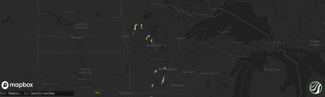
Wind
Hail
Tornado
464
Estimated number of impacted properties by a 1.00" hail or larger0
Estimated number of impacted properties by a 1.75" hail or larger0
Estimated number of impacted properties by a 2.50" hail or largerStorm reports in Minnesota
Minnesota
| Date | Description |
|---|---|
| 06/24/20235:30 PM CDT | Reported barn damage from tornado 47.309370... -95.933522. |
| 06/24/20234:59 PM CDT | Whitehill reports another touchdown near beltrami via nwschat. |
| 06/24/20234:57 PM CDT | H.anderson reports touchdown near flom. |
| 06/24/20234:52 PM CDT | Hunter anderson clalled about tornado with intermittent touchdowns near waubun. |
| 06/24/20234:52 PM CDT | Spotter mick elm called about 2 tornadoes forming from one with multiple vortices n. |
| 06/24/20234:38 PM CDT | Corrects previous tornado report from 2 ene mahnomen. Trees damaged. |
| 06/24/20234:37 PM CDT | S. Ebertowski from valley reports quarter size hail in mahnomen. |
| 06/24/20234:37 PM CDT | Valley news broadcaster reports quarter size hail in mahnomen. |
| 06/24/20234:30 PM CDT | Corrects previous tornado report from 2 ese mahnomen. Reported barn damage from tornado 47.314827... -95.931726. |
| 06/24/20234:25 PM CDT | Tornado confirmed near lockhart and went through tree grove norman em was going to survey for damage. |
| 06/24/20234:15 PM CDT | Norman em reported touchdown near shelly heading n-nw. |
| 06/24/20234:05 PM CDT | Tornado touchdown near borup. |
| 06/24/20234:00 PM CDT | Trees damaged. |
| 06/24/20233:59 PM CDT | Public confirms tornado with picture via twitter. |
| 06/24/20233:57 PM CDT | Corrects previous tornado report from 3 s flom. Hunter anderson reports touchdown near flom. |
| 06/24/20233:30 PM CDT | Spotter confirms tornado near ada with picture via twitter. |
| 06/24/20233:20 PM CDT | Met sent us tornado picture via twitter 6 w of callaway. |
| 06/24/20233:20 PM CDT | Wday broadcaster sent us photos of tornado still moving. |
| 06/24/20233:20 PM CDT | Dillon vogt from wday sent us photos of tornado still moving. |
| 06/23/20239:28 PM CDT | Hail for up to 30 minutes. Mostly around a half inch in size... But a few were up to the size of quarters. Time estimated from radar. |
| 06/23/20238:32 PM CDT | A local report indicates 1.00 inch wind near Biscay |
All States Impacted by Hail Map on June 24, 2023
Cities Impacted by Hail Map on June 24, 2023
- Lake Benton, MN
- Holland, MN
- Ruthton, MN
- Balaton, MN
- Tyler, MN
- Arco, MN
- Russell, MN
- Pipestone, MN
- Taunton, MN
- Minneota, MN
- Lynd, MN
- Ivanhoe, MN
- Marshall, MN
- Ghent, MN
- Woodstock, MN
- Paton, IA
- Harcourt, IA
- Ogden, IA
- Dayton, IA
- Stratford, IA
- Pilot Mound, IA
- Boxholm, IA
- New Market, IA
- Nemaha, IA
- Madrid, IA
- Boone, IA
- Humboldt, IA
- Liscomb, IA
- Albion, IA
- Conrad, IA
- Audubon, IA
- Manning, IA
- Bedford, IA
- Clarinda, IA
- Gravity, IA
- Blairsburg, IA
- Jefferson, IA
- Dana, IA
- Grand Junction, IA
- Mount Vernon, MO
- Miller, MO
- Lehigh, IA
- Otho, IA
- Storm Lake, IA
- Early, IA
- Newell, IA
- Sac City, IA
- Braddyville, IA
- Ellsworth, IA
- Craig, MO
- Mound City, MO
- Clare, IA
- Dakota City, IA
- North Port, FL
- Farnhamville, IA
- Lakeland, FL
- Ackworth, IA
- Milo, IA
- Stanhope, IA
- Indianola, IA
- Fort Pierce, FL
- Knoxville, IA
- Pleasantville, IA
- Lake Park, MN
- Hampton, IA
- Lake Andes, SD
- Wagner, SD
- Spencer, NE
- Bristow, NE
- Lynch, NE
- Parkersburg, IA
- New Hartford, IA
- Albia, IA
- Shell Rock, IA
- Cedar Falls, IA
- Janesville, IA
- Waverly, IA
- Ada, MN
- Avon, SD
- Niobrara, NE
- Moravia, IA
- Blakesburg, IA
- Ottumwa, IA
- Springfield, SD
- Denver, IA
- Waterloo, IA
- Readlyn, IA
- Dunkerton, IA
- Walnut, IA
- Avoca, IA
- Marne, IA
- Atlantic, IA
- Agency, IA
- Eldon, IA
- Bloomfield, IA
- Floris, IA
- Fairbank, IA
- Oran, IA
- Oelwein, IA
- Dumont, IA
- Aredale, IA
- Platte, SD
- Chamberlain, SD
- Kimball, SD
- Utica, SD
- Yankton, SD
- Mission Hill, SD
- Volin, SD
- Bloomfield, NE
- Crofton, NE
- Hartington, NE
- Vermillion, SD
- Sumner, IA
- Westgate, IA
- Selma, IA
- Douds, IA
- Keosauqua, IA
- Birmingham, IA
- Bonaparte, IA
- Stockport, IA
- Mayville, ND
- Portland, ND
- Mahnomen, MN
- New Prague, MN
- Badger, IA
- Roseland, LA
- Kilkenny, MN
- Chariton, IA
- Maringouin, LA
- Grosse Tete, LA
- Elysian, MN
- Edgard, LA
- Wellsburg, IA
- Waterville, MN
- Janesville, MN
- Gowrie, IA
- Jonesville, LA
- Lohrville, IA
- Lovilia, IA
- Alden, IA
- Bejou, MN
- Picayune, MS
- Carriere, MS
- Geneva, IA
- Baton Rouge, LA
- Columbia, IA
- Melcher Dallas, IA
- Baker, LA
- Harrisonburg, LA
- Steamboat Rock, IA
- Ackley, IA
- Zachary, LA
- Port Allen, LA
- Sicily Island, LA
- Montgomery, MN
- Elk Horn, IA
- Fosston, MN
- Waubun, MN
- Mystic, IA
- Rockwell City, IA
- Port Saint Lucie, FL
- Prole, IA
- Saint Charles, IA
- Saint Marys, IA
- Otley, IA
- Pella, IA
- Woodburn, IA
- Lucas, IA
- Osceola, IA
- Hingham, MT
- Loxahatchee, FL
- Mason City, IA
- Rockwell, IA
- Callender, IA
- Churdan, IA
- Duncombe, IA
- Fort Dodge, IA
- New Virginia, IA
- Naples, FL
- Truro, IA
- Belle Glade, FL
- Jewell, IA
- Melrose, IA
- Russell, IA
- Hamilton, IA
- Sheffield, IA
- Bradford, IA
- Iowa Falls, IA
- Everton, MO
- Ash Grove, MO
- Denham Springs, LA
- Sebeka, MN
- Menahga, MN
- Hillsboro, IA
- Donnellson, IA
- West Point, IA
- Saint Paul, IA
- Palmyra, MO
- Taylor, MO
- Maywood, MO
- Quincy, IL
- Liberty, IL
- Payson, IL
- Fowler, IL
- Plainville, IL
- Clarence, MO
- Lentner, MO
- Shelbina, MO
- Shelbyville, MO
- Hunnewell, MO
- Emden, MO
- Nevis, MN
- Akeley, MN
- Hannibal, MO
- Hull, IL
- Monroe City, MO
- Philadelphia, MO
- Merkel, TX
- Hawley, TX
- Abilene, TX
- Tye, TX
- Mertzon, TX
- Brownton, MN
- Glencoe, MN
- Hutchinson, MN
- Silver Lake, MN
- Kahoka, MO
- San Angelo, TX
- Wayland, MO
- Trent, TX
- New London, MO
- Kinderhook, IL
- Algona, IA
- Wesley, IA
- Carlsbad, TX
- New Canton, IL
- Rockport, IL
- Alta, IA
- Truesdale, IA
- Rembrandt, IA
- Pleasant Hill, IL
- Wilton, IA
- Durant, IA
- New Liberty, IA
- Walcott, IA
- Stockton, IA
- Davenport, IA
- Ruthven, IA
- Emmetsburg, IA
- Eldridge, IA
- Bettendorf, IA
- Pleasant Valley, IA
- Cylinder, IA
- Pecatonica, IL
- Winnebago, IL
- Rockford, IL
- Machesney Park, IL
- Loves Park, IL
- Byron, IL
- Stillman Valley, IL
- Davis Junction, IL
- Cherry Valley, IL
- Belvidere, IL
- Kirkland, IL
- Monroe Center, IL
- Poplar Grove, IL
- Caledonia, IL
- Marengo, IL
- Genoa, IL
- Garden Prairie, IL
- Ursa, IL
- Mount Hermon, LA
- New Sharon, IA
- Mallard, IA
- Fontanelle, IA
- La Porte City, IA
- Dysart, IA
- Bagley, MN
- Ely, IA
- Whittemore, IA
- West Bend, IA
- Center Point, IA
- Mount Auburn, IA
- Central City, IA
- Vinton, IA
- Urbana, IA
- Walker, IA
- Nora Springs, IA
- Rudd, IA
- Floyd, IA
- Luray, MO
- Arbela, MO
- Gorin, MO
- Wyaconda, MO
- Lynnville, IA
- Grinnell, IA
- Sully, IA
- Ballinger, TX
- Rowena, TX
- Strawberry Point, IA
- Edgewood, IA
- Manchester, IA
- Searsboro, IA
- Ironwood, MI
- Bessemer, MI
- Amite, LA
- Miles, TX
- Lacona, IA
- La Grange, MO
- Lewistown, MO
- Monticello, MO
- Clinton, LA
- McCamey, TX
- Iraan, TX
- Midkiff, TX
- Ozona, TX
- Reasnor, IA
- Montezuma, IA
- Big Lake, TX
- Canton, MO
- Wiota, IA
- Lewis, IA
- Graettinger, IA
- Nashua, IA
- Greene, IA
- Charles City, IA
- Curlew, IA
- Britt, IA
- Drakesville, IA
- Baylis, IL
- Motley, MN
- Clarksville, IA
- Ionia, IA
- Tylertown, MS
- Fenton, IA
- Cumberland, IA
- Ayrshire, IA
- Anabel, MO
- Osyka, MS
- Franklinton, LA
- Mccomb, MS
- Dyess Afb, TX
- Keswick, IA
- Gibson, IA
- What Cheer, IA
- Barnes City, IA
- Rose Hill, IA
- Aurelia, IA
- Park Rapids, MN
- Fort Madison, IA
- Kentwood, LA
- Newton, IA
- Killduff, IA
- Bogalusa, LA
- Deep River, IA
- Batavia, IA
- Unionville, IA
- Centreville, MS
- Traer, IA
- Pilot Rock, OR
- Eddyville, IA
- Camp Point, IL
- Ewing, MO
- Durham, MO
- Ashburn, MO
- Clayton, IL
- Barry, IL
- Libertyville, IA
- Farmington, IA
- Denmark, IA
- Wever, IA
- Evansdale, IA
- Raymond, IA
- Jesup, IA
- Plano, IL
- Yorkville, IL
- Aplington, IA
- Alexander, IA
- Kanawha, IA
- Corwith, IA
- Latimer, IA
- Belmond, IA
- Lu Verne, IA
- Dike, IA
- Laurel, NE
- Dixon, NE
- Newcastle, NE
- Little Falls, MN
- Sherburn, MN
- Dunnell, MN
- Coal Valley, IL
- Weldon, IA
- Brainerd, MN
- Dickens, IA
- Pequot Lakes, MN
- Goldfield, IA
- Renwick, IA
- Griggsville, IL
- Chambersburg, IL
- Lost Nation, IA
- Pine River, MN
- Albert City, IA
- Lowden, IA
- Clarence, IA
- Bennett, IA
- Tipton, IA
- Gilbertville, IA
- Throckmorton, TX
- Cedar Rapids, IA
- Palo, IA
- Hamel, MN
- Plano, IA
- Nebo, IL
- Garner, IA
- Burkett, TX
- Gladstone, IL
- Fort Ripley, MN
- Ainsworth, IA
- Crawfordsville, IA
- Lester Prairie, MN
- Humeston, IA
- West Liberty, IA
- Muscatine, IA
- Nichols, IA
- Ringsted, IA
- Wallingford, IA
- Moline, IL
- Cross Plains, TX
- Corydon, IA
- Lone Rock, IA
- Kampsville, IL
- Versailles, IL
- Havelock, IA
- Garrison, IA
- Reinbeck, IA
- Udell, IA
- Centerville, IA
- Timewell, IL
- Pillager, MN
- Baxter, MN
- Coatsburg, IL
- Paloma, IL
- Mendon, IL
- Ventura, IA
- Clear Lake, IA
- Louisiana, MO
- Marion, IA
- Lewisville, MN
- Saint James, MN
- Madelia, MN
- Sigourney, IA
- Webster, IA
- South English, IA
- Streator, IL
- Delta, IA
- Stamford, TX
- Stout, IA
- Solon, IA
- Montrose, IL
- Greenup, IL
- Jewett, IL
- Toledo, IL
- Sperry, IA
- Burlington, IA
- Derby, IA
- Donahue, IA
- Long Grove, IA
- Dixon, IA
- Baird, TX
- Oxford Junction, IA
- Wheatland, IA
- Anson, TX
- Sudan, TX
- Holland, IA
- Livermore, IA
- Hardy, IA
- Minneapolis, MN
- Wayzata, MN
- Norwood, LA
- Argyle, IA
- Keota, IA
- Pearl, IL
- Clarksville, MO
- Frankford, MO
- Rockford, IA
- Hudson, IA
- West Branch, IA
- Backus, MN
- Verona, IL
- Morris, IL
- Lerna, IL
- Bancroft, IA
- Hidalgo, IL
- Bruceville, IN
- Bicknell, IN
- Oaktown, IN
- Leitchfield, KY
- Ashmore, IL
- Casey, IL
- Westfield, IL
- Marshall, IL
- Martinsville, IL
- Kansas, IL
- Robinson, IL
- Hutsonville, IL
- Palestine, IL
- Kentland, IN
- Huntingburg, IN
- Ferdinand, IN
- Holland, IN
- Dale, IN
- Avon, IL
- Berwick, IL
- Marshall, IN
- Rockville, IN
- Oquawka, IL
- Goodland, IN
- Newton, IL
- Yale, IL
- Flat Rock, IL
- Clay City, IN
- Charleston, IL
- Willow Hill, IL
- Kirkwood, IL
- Biggsville, IL
- Stronghurst, IL
- Media, IL
- Smithshire, IL
- Sheldon, IL
- Watseka, IL
- Roseville, IL
- Saint Augustine, IL
- Minooka, IL
- Campbellsburg, IN
- Irvington, KY
- Oblong, IL
- Buckley, IL
- Cissna Park, IL
- Onarga, IL
- Bloomingdale, IN
- Kingman, IN
- Terre Haute, IN
- Lewis, IN
- Coal City, IN
- Carlisle, IN
- Lawrenceville, IL
- Sumner, IL
- Paris, IL
- Caneyville, KY
- Gays, IL
- Farmersburg, IN
- Shelburn, IN
- Pimento, IN
- Neoga, IL
- Trilla, IL
- Broadlands, IL
- Homer, IL
- Sidney, IL
- Dubois, IN
- Earl Park, IN
- Brook, IN
- Fowler, IN
- Albion, IL
- Crescent City, IL
- Hindsboro, IL
- Oakland, IL
- Independence, IA
- Nisswa, MN
- Milford, IL
- Wheatland, IN
- Celestine, IN
- Washington, IN


